Monitoring Natural Disasters in the Philippines
More than 20 typhoons take place every year in the Philippines, five of which are typically destructive, taking a toll on not only infrastructure but also human life. The country’s location also makes it vulnerable to other natural disasters including frequent earthquakes, volcanic eruptions as well as tsunamis, sea-level rise, storm surges, landslides, flooding, and drought.
As such, predicting areas of typhoon damage, and other natural disasters, is a key focus of The Department of Science and Technology (DOST-ASTI). As part of the Advanced Science and Technology Institute in the Philippines, DOST-ASTI aims to deliver technology solutions that support a productive and resilient Philippine society. Without access to satellite imagery and data, DOST-ASTI had to rely on extracting ground-based data, which had a long latency causing delays in getting timely information to top-level decision makers.
After years of manually monitoring, DOST-ASTI needed a better way to improve disaster management and monitoring, and inform natural disaster policies, so they connected with Planet partner, Geospectrum, to access Planet satellite data.
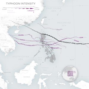
Map of Typhoons that made landfall in the Philippines during the 2020 typhoon season. The opacity of the typhoon path corresponds to the intensity of the storm, while the width indicates the relative radius of the storm. © 2020, Planet Labs Inc. All Rights Reserved.
“We recognized that if we could add in the information provided by satellite imagery into our workflows, this would provide us a more accurate perspective on what really happened at the ground level,” said Harold Bryan S. Paler, Senior Science Research Specialist at DOST-ASTI. “When we ventured into space activities we had subscriptions to commercial satellites, but these presented new challenges, the main one being the long temporal revisit. For example, if we wanted to capture images in the area we had, we had to wait several days before we could get the capture. This was not sufficient for effective disaster response and the environmental monitoring we required.”
Today the DOST-ASTI leverages satellite images to monitor pre- and post-typhoon incidents, and better manages and responds to other natural disasters as well with more timely, accurate analysis so the appropriate authorities can make informed decisions.
Once a typhoon hits, Planet’s satellite imagery allows DOST-ASTI to assess the damage that has occurred, and uses the monitoring data to benefit the country’s citizens by providing real-time information. Further, the data help its government formulate policies based on research studies using satellite data.
According to Paler, “Because of Planet’s high-temporal resolution, we are able to get the images as soon as possible and then proactively send them to different government units and disaster management councils who require this information.”
Download the case study to learn more about how GEOSPECTRUM and DOST-ASTI are working together to improve upon disaster management and monitoring in the Philippines.


)