Search

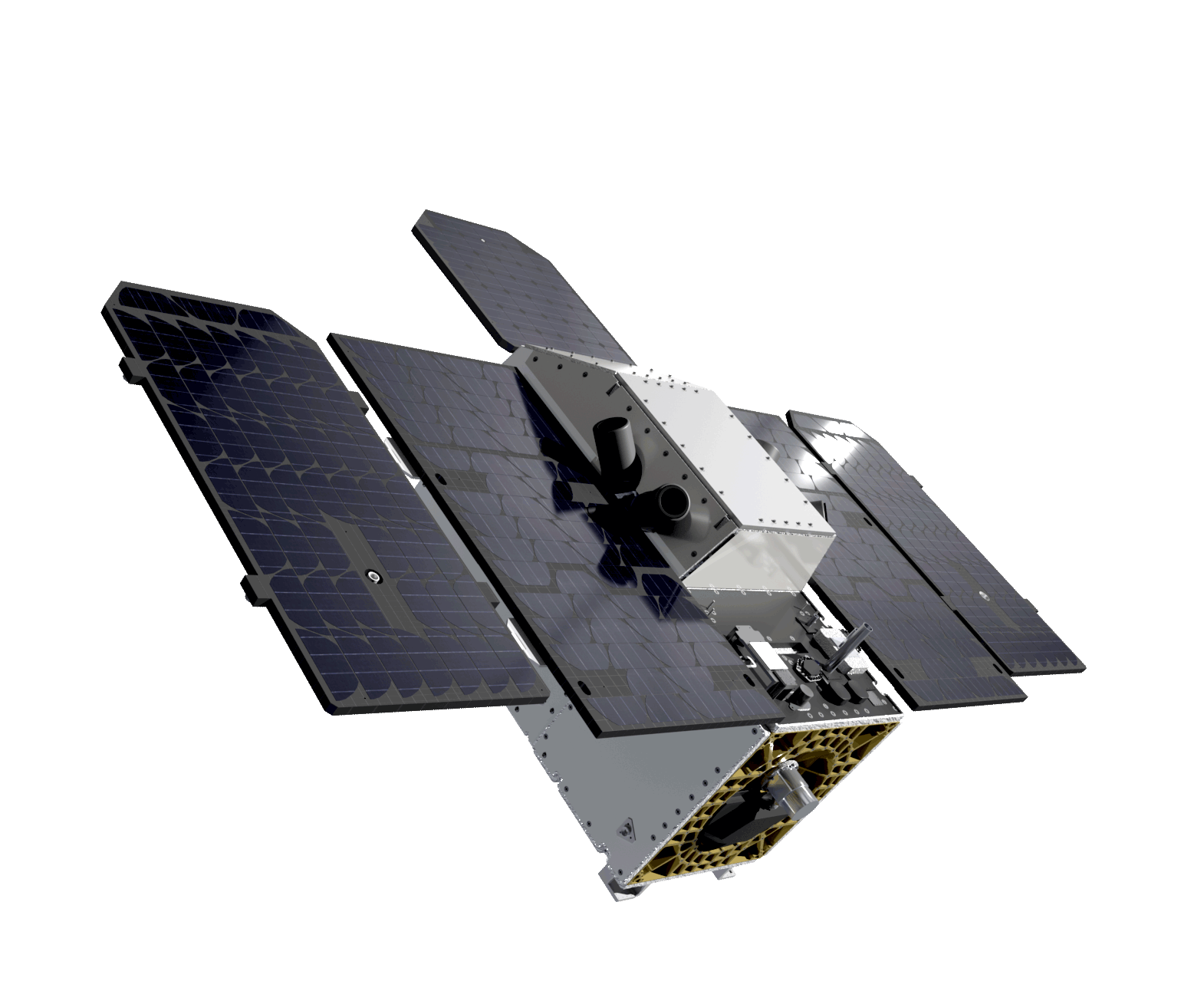
TANAGER
Cutting-Edge Hyperspectral from Orbit
Planet’s hyperspectral imaging satellites are pushing the boundaries of earth observation and methane emissions monitoring.
Superior System Performance
Hyperspectral Data, Without all the Noise
Effective decisions rely on trustworthy data. Tanager™ is a best-in-class hyperspectral imaging satellite offering unparalleled sensitivity, designed to deliver full-spectrum imagery across the visible and shortwave infrared regions (VSWIR). Engineered by NASA’s Jet Propulsion Laboratory and sponsored by Carbon Mapper, Tanager’s next-generation sensor technology empowers your organization to make critical, time-sensitive decisions with confidence. Quickly uncover regional trends and deviations from historical patterns with Tanager’s broad area coverage and rapid-access data.
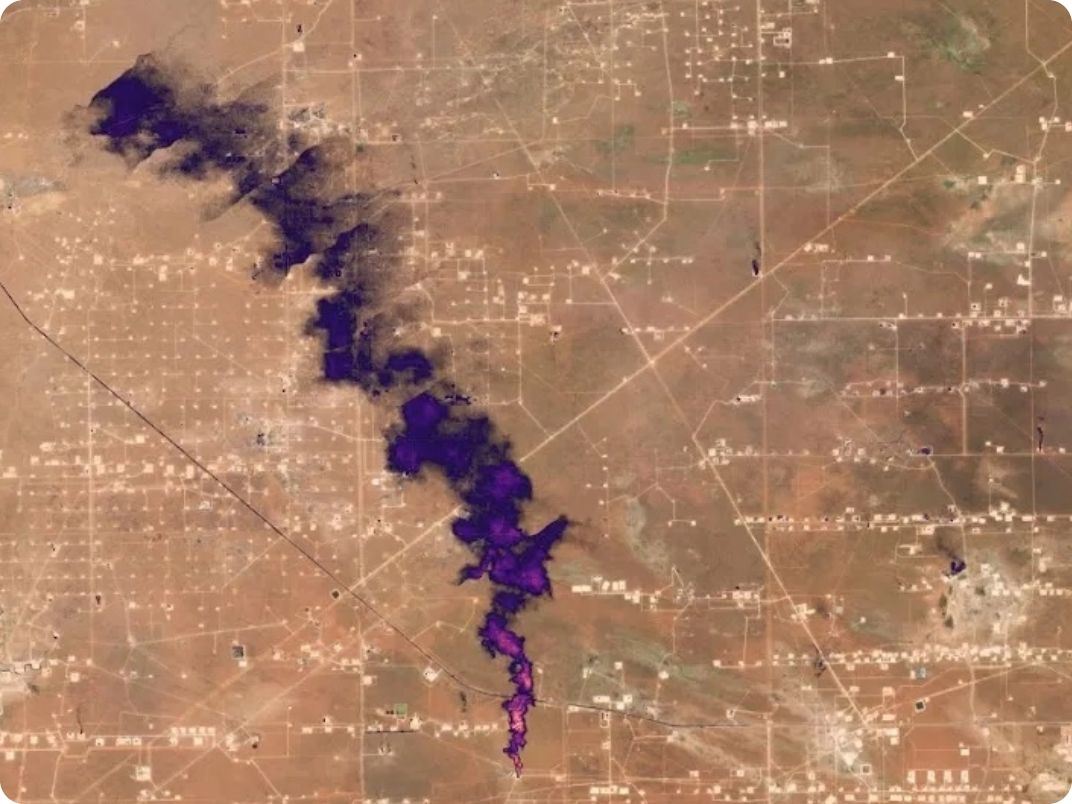
Timely and Accurate Methane Emission Detections
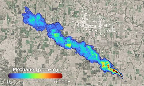
Tanager supports a broad spectrum of applications, but its core mission is to detect and mitigate methane emissions across the globe. Tanager is able to map facility-scale methane emissions to enhance leak detection and repair efforts.
Unprecedented
Sensitivity
Detect smaller emissions more frequently with 3-6 more sensitivity than comparable spaceborne systems
Broad
Coverage
Monitor widely distributed assets and facilities with Tanager’s expansive coverage
Rapid
Delivery
Find leaks faster with rapid data delivery and help speed time to action
Context
Imaging
Trace likely source of emissions detections to facility equipment with Planet’s high-frequency Monitoring and high-resolution Tasking imagery


90kg/hr1
Methane Detection Limit
72hr
Methane Delivery Latency
30m
Ground Sampling Distance
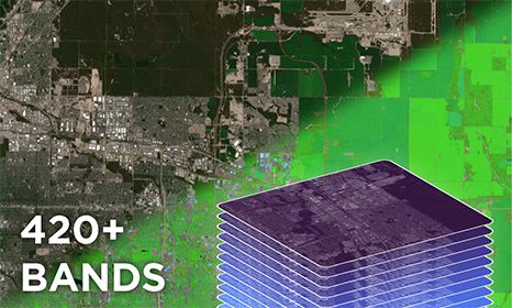
>420
Spectral Bands
5nm
Spectral Sampling
18km
Swath Width
300-6002
SNR at the CH4 Band
>420
Spectral Bands
400-2500nm
Spectral Range
5nm
Spectral Sampling
Weekly3
Revisit Rate
18km
Swath Width
190% probability of detection, Maximum sensitivity imaging mode, point source, 3m/s wind, medium surface brightness, 35° solar zenith angle.
2Signal-to-Noise Ratio achievable through increased effective integration time.
3Assumes one satellite, no competition, and Assured Tasking point target collection.
Analysis Ready Hyperspectral Data Products
Slated for release in late 2024, Tanager’s planned hyperspectral offering includes core imagery and derived methane detection data. Customized tasking and multiple sensitivity operational modes will enable custom imagery collection designed to fit your specific business needs. Tasking, ordering, and delivery of Tanager products are planned to be made possible through Planet’s easy-to-use APIs.
Core Imagery
Tanager’s planned core imagery data include calibrated radiance and atmospherically-corrected surface reflectance. These ready-to-use data products are intended for customers who want to utilize the full spectral range to extract application-specific insights.
Core imagery is planned to be available in HDF-5 format, unrectified or rectified. Imagery will be delivered through Planet’s APIs within 24 hours of image acquisition.
- Radiance - calibrated spectral radiance data for users interested in performing their own atmospheric corrections and custom analyses.
- Surface Reflectance - atmospherically-corrected reflectance data, processed using the ISOFIT family of algorithms, for users aiming to quickly investigate Earth's surface materials and properties.
Methane
Derived in partnership with Carbon Mapper, these products leverage state-of-the-art methane detection algorithms. Tanager’s planned Methane offerings includes Quicklook and Quality Controlled products described below.
Both offerings include GeoTIFF plume imagery, methane concentrations (in ppm-m), plume origin coordinates, and observation date & time.4
- Methane Quicklook - expected to be available through Planet’s APIs within 72 hours after acquisition with an initial emission quantification estimate for rapid leak detection and repair.
- Methane Quality Controlled - expected to be available through Planet’s APIs within 15 days after acquisition with reliable emission quantification estimates for improved environmental reporting.
4 Additional metadata includes emission uncertainty, wind speed, wind direction, and more.
Learn more about Planet’s hyperspectral offerings by downloading this datasheet.
Download DatasheetFrequently Asked Questions
Discover how Tanager can create value for your business.
Contact sales to learn more about how Tanager can bring new insights to your biggest challenges, starting late 2024.
© 2025 Planet Labs PBC. All rights reserved.
| Privacy Policy | California Privacy Notice |California Do Not Sell
Your Privacy Choices | Cookie Notice | Terms of Use | Sitemap
