Anatomy of a Catastrophe
Planet’s daily monitoring of Hurricane Harvey shows how frequent data can help governments, insurers, and first responders direct emergency relief efforts and better prepare for natural disasters in the future.

Ten years ago, quiet rippled across the Permian Basin, a 75,000 square-mile expanse stretching from West Texas to southeastern New Mexico. The last major oil boom, dating back to the late 1970s, had bottomed out and the industry prepared to call the region tapped.
But almost in the blink of an eye, the rumblings of drills and pumps began anew. New methods for extracting oil from shale rock had the industry rushing back to the Permian Basin as they first did 100 years ago. Today, the Permian Basin is arguably the most important region for US oil production.
Planet’s data allows us to detect and map new oil and gas developments in near-real-time. In this Insight, we travel to the Midland-Odessa region of the Permian Basin and use well pad detection to monitor daily site progress, map new regional activity, and track against historical output.
Completed oil wells across six counties (Culberson, Loving, Pecos, Reeves, Ward, Winkler). Source: Texas Railroad Commission
The last oil boom in the Permian Basin peaked in 1973, when the region produced a record 790 million barrels of oil. As production slowed through the early 1990s, the number of wells in the region slumped. This shifted around 2010, when new fracking and horizontal drilling methods prove to recover oil from shale and wells begin springing up across the Permian once more.
Today, the rapid pace of development in the Permian makes monitoring the oil and gas industry challenging. The frequency, speed, and completeness of data can greatly shift one’s understanding of what is going on in the Midland-Odessa Basin and other regions.
Leveraging our global daily data, Planet built an algorithm that automatically detects the presence of wells. Here you can see the total number of wells in the Midland-Odessa up to present day.
White dots highlight the newest wells algorithmically detected for the week of March 12.
At first glance, Planet’s detection tool appears to align with publicly available data from the Texas Railroad Commission.
But when you take a closer look at recent data, you see there is significant gap between our live algorithm and publicly available data. In fact, as of late February, the Texas RRC’s digital map data was only updated through the end of 2017 – effectively showing no new wells for this year.
Planet’s high-cadence, high-resolution data allows for week-to-week detection and monitoring that gives a more comprehensive view of what’s happening on the ground.
Here are Planet’s detections through February 1.
Based on Planet’s detection tool, 106 new wells have been identified in the Midland-Odessa region. Knowing if and when wells go into operation is a vital source of competitive and market intelligence for industry.
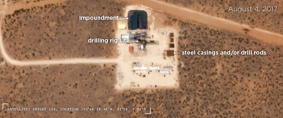
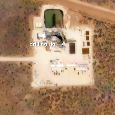
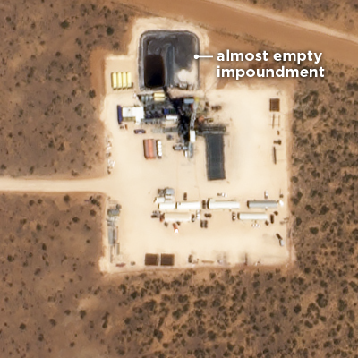
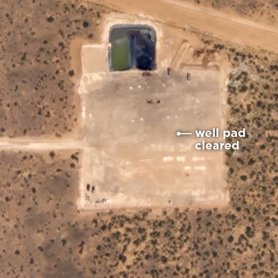
After identifying well pad development, SkySats can be automatically tasked to assess different stages of construction in detail.
August 13, 2017
September 22
November 2
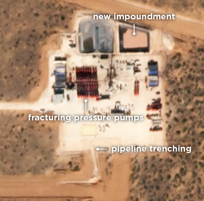
November 19
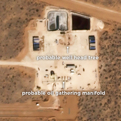
January 8, 2018
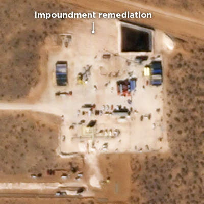
January 18
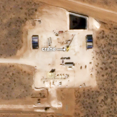
January 23
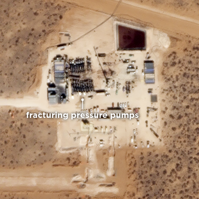
March 3
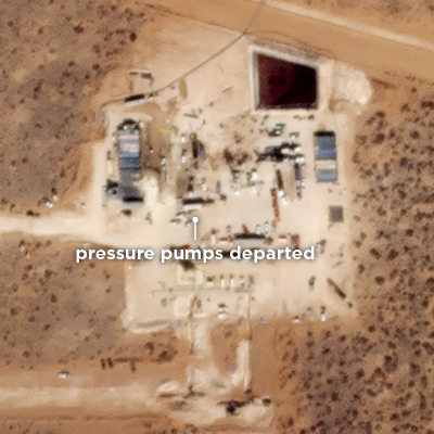
March 5
The Permian Basin is arguably the epicenter of what many are calling the next US oil boom, with the largest energy companies doubling down on their investments for the next decade.
With frequent, hi-resolution imagery, energy companies can manage assets across multiple sites and track competitor operations. Financial institutions can monitor energy production to understand global energy markets. And insurance companies can assess risk and evaluate impacts after accidents and natural disasters.
Planet’s combination of high-resolution, near-real-time satellite imagery and state-of-the-art data analysis allow tracking of oil development in the Permian Basin and other places like no other dataset.
Writing and Editing: Jenna Mukuno, Ian Ritchey
Data Visualization: Robert Simmon, Daniel Wolfe
Development: Orestis Herodotou, Daniel Wolfe
Drone Footage Courtesy of the Texas Drone Specialist
Sources: Planet Labs Inc., Texas Railroad Commission
Planet’s daily monitoring of Hurricane Harvey shows how frequent data can help governments, insurers, and first responders direct emergency relief efforts and better prepare for natural disasters in the future.
A state of emergency for Napa, Sonoma, Mendocino, Lake, Butte and Yuba counties has been declared as more than a dozen wildfires rage across Northern California. In response, we are making our satellite data available to everyone that needs it.

Explore the value of high-cadence, high-resolution satellite data for quantifying and analyzing global change. For more on monitoring for energy and infrastructure or to learn how to leverage Planet imagery for daily global insights, get started today.
Share