Responding to the Nepal Earthquake
Update (5/13/15): Read this great blog post by Zooniverse to learn how satellite imagery and coordination between many organizations enables relief efforts.
Update: We have just completed a mosaic of our archival, pre-earthquake imagery to aid disaster assessment efforts. For access, email disaster-response@planet.com.
The devastating 7.8 magnitude earthquake that struck late Saturday evening in Nepal is a disaster of the first order, and our hearts break for the thousands of people whose lives have been lost, hurt and deeply disrupted. The tragedy is still unfolding, and timely information and targeted support is urgently needed to ensure that the response is as effective as possible.
The digital humanitarian community has been robustly engaged, and many organizations around the world are contributing data and talent to assist on-the-ground efforts. Facebook has activated its Safety Check service, and Google has done the same with its Person Finder feature, both of which help connect people inside and outside of the affected areas. DigitalGlobe, through its Tomnod effort, has made post-disaster images of Kathmandu available; Mapbox has processed this imagery and provided it to Humanitarian OpenStreetMap.
On the ground, the team at Kathmandu Living Labs is busily coordinating the OpenStreetMap volunteers in getting accurate, timely and mobile-friendly maps and information to first responders.
Many others in the crisis mapping community are also hard at work, including CrisisMappers and Ushahidi (which has a great post on how to support online volunteer response). Governments are participating, too – India, for example, is sending UAVs to help map the destruction.
What Planet Labs is Doing
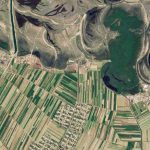
While Planet Labs’ own imagery and services are still evolving, over the past few months we have captured significant imagery of currently-affected areas in Nepal, including Kathmandu.

A Planet Labs image of urban Kathmandu taken on March 9, 2015
We are engaged participants in the International Charter on Space and Major Disasters, an international space charter that ensures timely satellite data is made available to rescue authorities. Within hours of the earthquake, we began working to make our imagery archive of the region (about 3000 scenes) available to the public on the Hazards Data Distribution System run by the US Geological Survey.
All of our available, public data is provided under a truly open usage license (CC BY-SA), with all tracing of imagery for OpenStreetMap allowed. The open data license means that our imagery will be accessible indefinitely for responders and researchers to analyze and improve response efforts in the future.
Already, organizations as diverse as OpenStreetMap, IFC, World Vision International, and the Lamont-Doherty Earth Observatory have requested data access, and we remain in regular contact with many others involved.
In the days and weeks to come, we will capture additional, post-earthquake imagery, and will provide continuous updates as we collect data. To enable faster access to our raw and mosaicked imagery, we are offering our platform, beta web tools, and API keys to interested parties. If you’re interested in contributing to relief efforts and would like access to our platform, please contact disaster-response@planet.com.
At Planet Labs, our founding intent is to use space to help life on Earth. We’re constantly improving our hardware capabilities, image quality and data pipeline. We hope to help improve the response to, and diminish the suffering caused by, this terrible tragedy. If you have specific data needs, ideas or suggestions for how we can help, please contact us.

)