
2025 Year in Review: Product Innovations From the Agile EO Webinar Series

SkySat image of Pearl in Qatar, captured September 18, 2025. © 2025 Planet Labs PBC. All Rights Reserved.
Tech2025 was a year defined by accelerated change, both on the Earth's surface and within our Earth observation toolkit. The Agile EO webinar series serves as the front line for Planet product and roadmap updates, keeping you current on our products and revealing major advancements across our data, platform, and solutions — in 30 minutes or less, each month.
As we look back on 2025, three key themes summarize the advancements we delivered to geospatial professionals worldwide. Read on to learn more, or explore our entire archive of Agile EO webinars.
1. Data Breakthroughs: Product Announcements and Enhancements
This year we highlighted improvements to our core offerings, including our first hyperspectral satellite and several resolution enhancements.
This idealized visualization highlights Tanager’s ability to capture broad areas such as energy producing regions.
Hyperspectral Data Enters the Market
A major announcement was the General Availability of Tanager™, our first hyperspectral satellite. This technology moves users beyond simply "seeing" a problem to "knowing" its precise cause. By capturing the full Visible to Shortwave Infrared (VSWIR) spectrum, Tanager unlocks signals for advanced analysis applications, including emissions detection and monitoring.
Improved Resolution for Planetary Variables™
To support advanced agricultural analysis, we introduced resolution enhancements across our analysis-ready Planetary Variables, including:
- Crop Biomass: The resolution for this product is being upgraded from 10 meter to an unprecedented 3 meter resolution.
- Soil Water Content (SWC) and Land Surface Temperature (LST): These products jumped from 100 meter to 20 meter resolution, providing a 25-fold increase in clarity for soil moisture and thermal analysis. Additionally, SWC now has 30 - 60% more observations due to the inclusion of other sources of passive microwave data such as AMSR2 X and C-bands.
In addition to these exciting new capabilities, the Agile EO series also provided in-depth discussions on the capabilities and applications for products, including an overview of our suite of products and a deep dive into Planet Monitoring, our flagship near-daily 3 meter resolution imagery covering all of Earth's landmass.
2. Platform and Workflow Optimization: Work Faster and Simpler
In 2025 we doubled down on ways to simplify the user experience, through improved data sharing and management within existing GIS tools.
Access satellite imagery quickly and pay-as-you-go in the Planet Select portal powered by our partners at SkyFi.
Planet Select (Formerly Single Order Tasking)
We introduced on-demand access to SkySat® 50 centimeter high-resolution tasked and archival imagery with the launch of Planet Select. The self-serve portal, powered by our partner SkyFi, enables rapid time-series analysis and project validation with a pay-as-you-go, no-contract model.
The Unified Planet Insights Platform Experience
We launched the brand-new unified web experience at insight.planet.com, consolidating tools previously available through Sentinel Hub. This brings the account, data, and analysis sections into a single hub to streamline your data workflows.
Cloud-Native GIS Integration
With the updated Planet Add-in for ArcGIS Pro, GIS professionals can now order Planet data to cloud-based data collections and stream imagery instantly via OGC services. This eliminates the need to manage and download large files locally, accelerating image sharing with others.
3. Automated Intelligence: Automate Decisions and Scale Compliance
We released new powerful machine learning and AI-driven systems designed to provide objective, automated intelligence for large-scale monitoring and verification programs.
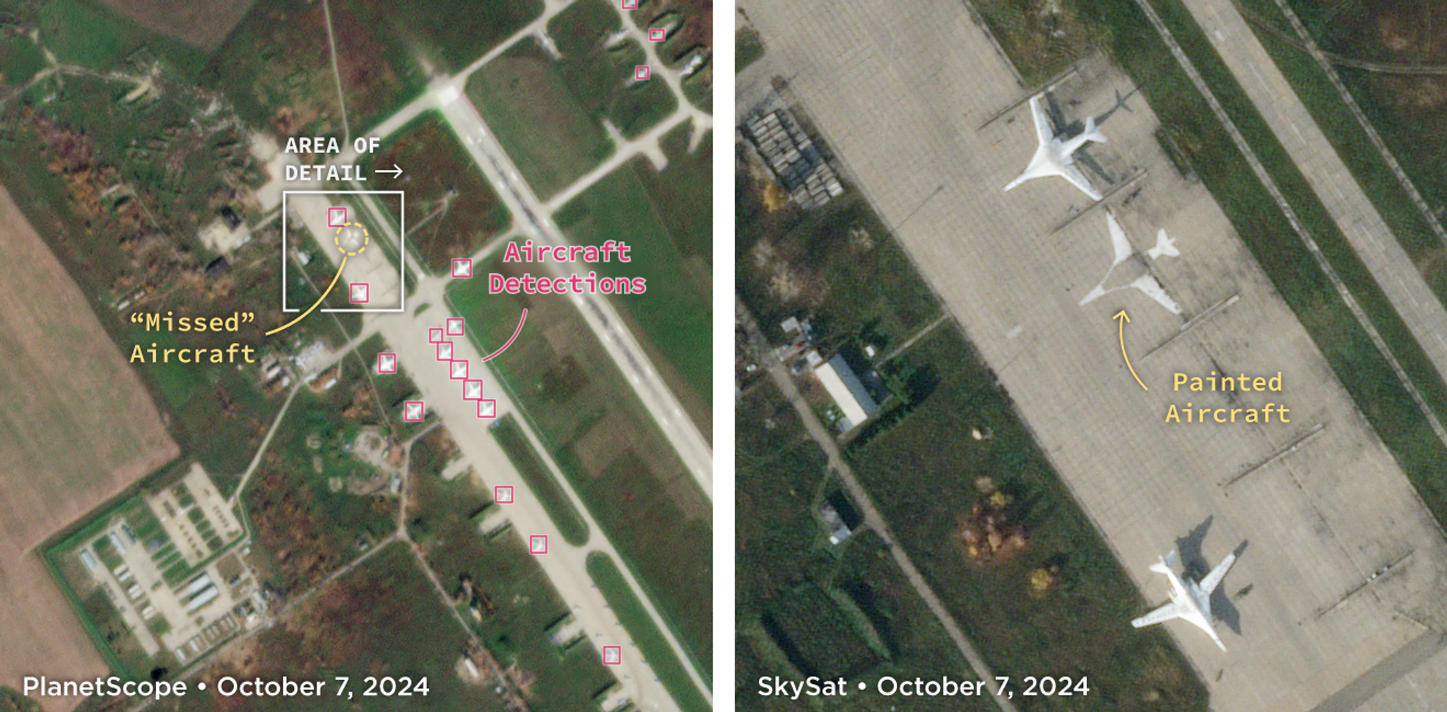
PlanetScope (left) detections showing a “missed” aircraft in the upper left. High-resolution SkySat imagery (right) illustrating that only paint exists at this location.
Aircraft Detection at Planetary Scale
We introduced a cutting-edge machine learning product that delivers near-daily, global detection of large aircraft by leveraging PlanetScope® and SkySat data. This innovative approach overcomes the inconsistency and volume limitations of traditional counting methods, enabling users to spot trends and anomalies across thousands of airfields.
Planet Area Monitoring Service (AMS)
This new end-to-end solution for agricultural verification and compliance addresses the challenge of enforcing regulations across millions of hectares. Planet AMS automates the validation process using a traffic light system (green/red/yellow) derived from field-level signals and markers. This objective, automated approach can help drastically reduce the time and cost associated with manual field inspections.
Ready to Revisit the Breakthroughs of 2025?
The past year at Planet brought game-changing innovation across our data, platform, and solutions. Whether your focus is on compliance, agriculture, defense, or conservation, the capabilities released in 2025 are designed to accelerate your impact.
Access the complete 2025 Agile EO webinar archive to watch the full episodes now!
And as you plan for 2026, register for the next episode in our series, Transform Tasking Workflows With Tasking Credits and Pelican Imagery, to explore next-generation tasking at Planet.
Ready to Get Started
Connect with a member of our Sales team. We'll help you find the right products and pricing for your needs.