Harnessing the Firehose
)
At Planet we’re on a mission to image all of the Earth’s landmass. We believe that if we can image everywhere on earth on a weekly or daily basis, we’ll be able to see change as it happens, and change the way people make decisions. Imaging the entire planet at high resolution requires a huge constellation of satellites all capturing data at the same time. To get this many satellites into orbit, Planet has taken a radically different approach from traditional earth observation satellite companies: we needed to dramatically reduce the cost of each satellite, iterate satellite design quickly, and deliver the most capable satellite per kilogram ever. In short, we needed to practice something we call ‘agile aerospace’.
Planet’s Doves started collecting imagery in high volumes just two years ago, in October of 2014. In that time, we have made significant progress, improving image quality, adding spectral bands, extending battery life, and increasing communications. These advances have brought us to today, where we’re now downloading 50 million square kilometers of imagery, daily. Most satellite manufacturers require years – if not more than a decade – to design, build, and launch a single spacecraft. In only 25 months, we’ve multiplied the capabilities of our satellites and built and launched 145 of them. And we’re just getting started.
How did we do it?
By following this agile aerospace approach, we’ve made it a priority to iterate and improve our various systems to deliver better results.
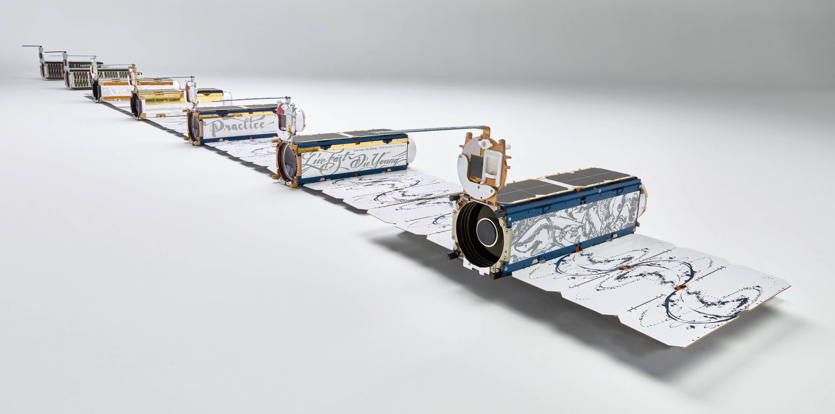
A selection of Dove builds ranging from Build 1 to Build 12
| Doves | Builds 1-5 | Builds 6-10 | Builds 11-13 |
| Operational Period | 2011-2012 | 2013-2014 | 2015-2016 |
| Optics | Off-the-shelf optics, narrow field of view | Custom telescope, focus mechanism | Second generation telescope with twice the field of view |
| Communications | Off-the-shelf S-band radio downlink | Custom X-brand radio downlink | Optimized comms system to gain – 500% increase in download rate, new antennas |
| Power | Lithium ion 7/5 AA cells, limited-efficiency solar cells | Custom pack with fuel gauge, solar charge controller, silicon solar cells | 100% battery capacity increase, high efficiency solar cells |
| Spectral Bands | Red, Green, Blue | Red, Green, Blue | Red, Green, Blue, NIR |
| Image Quality | Image vignetting, low SNR, suboptimal optical quality | Improved optical quality | Vignetting removed, good SNR, quality optical alignment |
| Capacity (km2/sat/day) | 3,000 | 500,000 | 2,500,000 |


Handling Scale
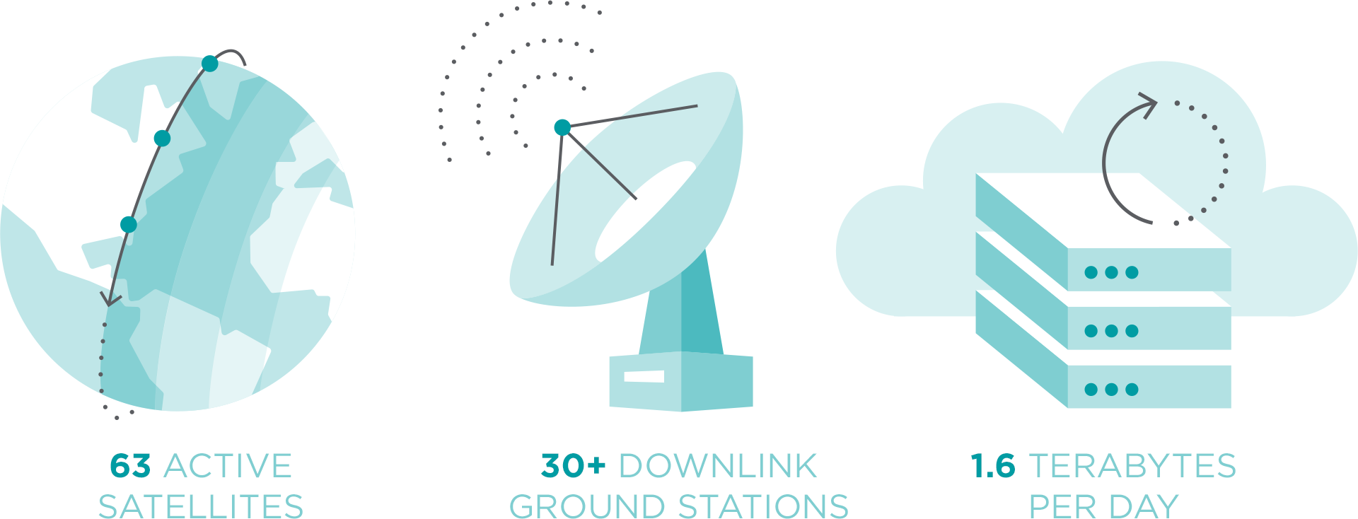
Today we have 60 satellites in orbit and producing a massive amount of data. This constellation produces approximately 1.6TB, or around 300,000 images, every day. Within 2016 alone, we expect to have collected over 9B km2 of imagery – or 60 times the amount of all of the Earth’s landmass. Collecting and downloading this much data from dozens of satellites takes an immense amount of coordination, which is where our Mission Control takes over. Never before has a mission control system needed to dynamically operate a fleet of this many imaging satellites, and schedule the downloading of data across a global network of 30-plus ground downlink locations, distributed globally.
Mission control has become so complex that we needed to automate the process —unlike other approaches, humans could no longer remain in the loop. That may sound trivial, but imagine 300,000 images arriving in your inbox each morning, each needing to be geo-located, orthorectified, color corrected and processed into a variety of different formats to allow for instant search, discovery and downloading over the internet. Planet accomplishes this complex set of tasks today.
Capturing 50,000,000 km2 per day
Following the June deployment of our Build 12 Dove satellites, we’re now collecting a significant amount of both RGB and near-infrared imagery (NIR). As you can imagine, we monitor this closely and over the past month have successfully downloaded an average of 50 Mkm2/day, which put another way is the land area equivalent of imaging all of North America every day, twice. And, accounting for clouds and unuseable imagery, we have successfully published 20Mkm2/day of both RGB and NIR imagery into our online catalog and API. As far as we can tell, publishing this amount of Earth observation data has never before been done or made available online.
Collection capacity from the Planet Dove constellation since October 2014
Planet collected at least one rectified image over 91 percent of the Earth’s surface in September 2016. Some areas—where clouds are rare and orbits frequently overlap—were imaged up to 126 times.
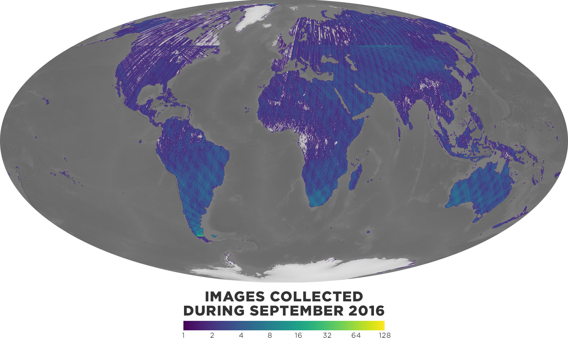
This map shows how much of the Earth’s landmass Planet satellites imaged in September 2016.
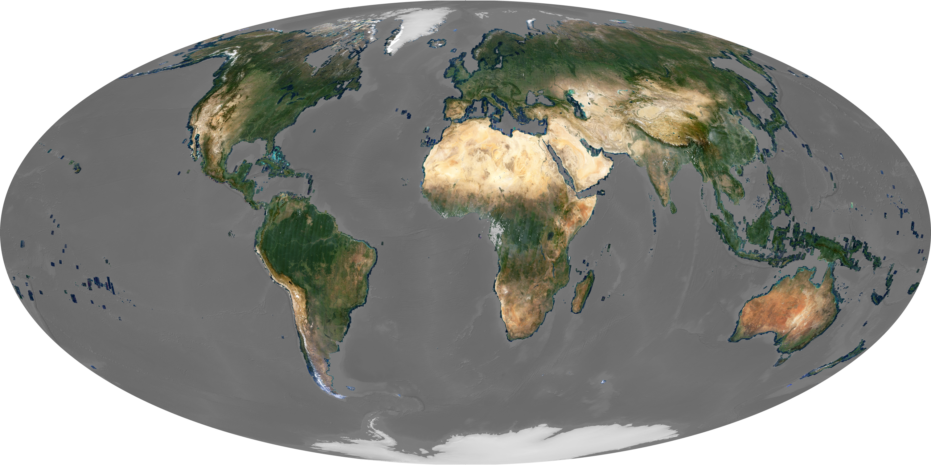
And you can see how this is looks across the entire world when we take the images collected from July through the end of September of 2016.
Getting it online
Getting several terabytes of data downloaded from low earth orbit and made available to customers online for simple search, discovery, and download is not easy. As stated earlier, every image needs a base level of processing that includes color correction and rectification. Obviously, this cannot be done by hand and required an automated system to manage it. We call it our automated data pipeline. A lot of proprietary technology powers our pipeline, which can not be detailed here. However, we can visualize the end result.
With this amount of data, you might be wondering what it looks like.
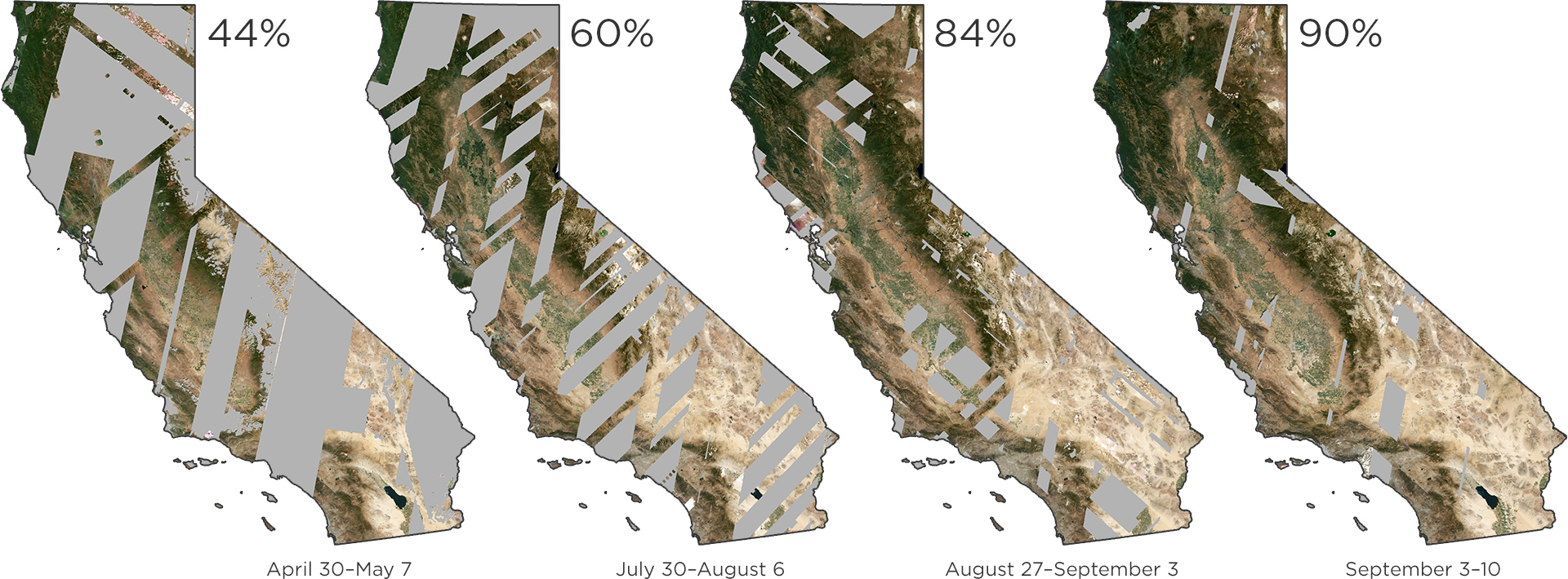
Each mosaic is formed from a single week of data collection over California. The collections above illustrate the increased capacity from May through the end of August.
An immense amount of thought, innovation, and work has been invested into each component of Planet’s end-to-end system, which includes everything from the satellites to the automated mission control software to the automated data pipeline. But, we’d argue that even more work has gone into making it all work together, seamlessly, so that our users are able to get the imagery they need, when they need it, to make better decisions. We have spent a lot of time brainstorming and envisioning what people will be able to do with our ‘firehose’ of up-to-date, global imagery. We’re excited that our firehose is no longer a concept of the future, but is today a tangible product delivering powerful, valuable information to customers around the world.
We’ve just crossed the halfway point in our pursuit of daily, global data, and it’s already proving to be an unmatched and powerful tool. With access to more data than ever about our planet, what would you build and which questions would you answer?