
Illuminate the Dark Fleet With Planet Maritime Domain Awareness
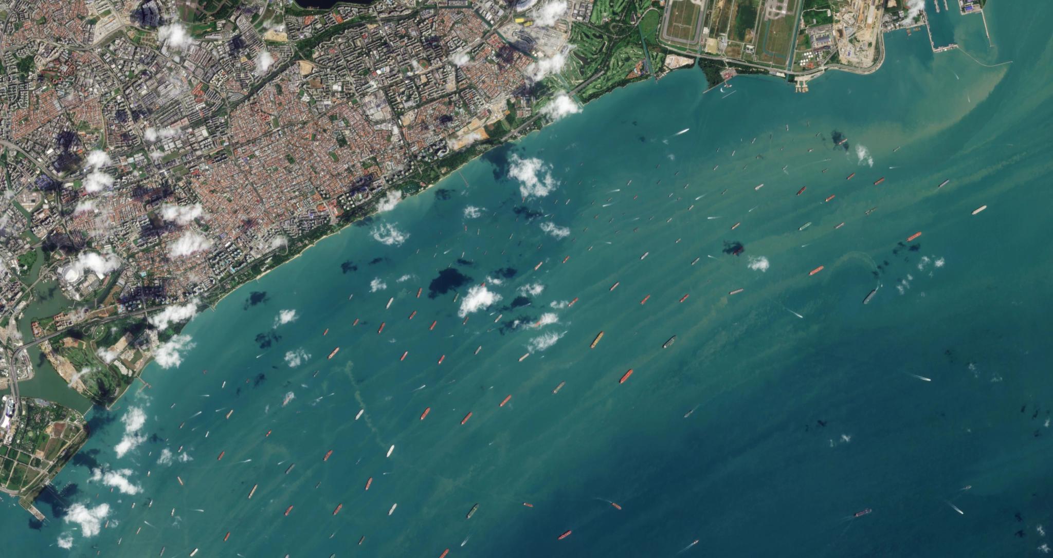
PlanetScope image showing vessel traffic in the Singapore Strait, captured January 3, 2025. © Planet Labs 2025. All rights reserved.
TechThe Planet Maritime Domain Awareness (MDA) solution combines unmatched satellite coverage and frequency with AI-enabled vessel detection and last-mile partnerships to remove blind spots and deliver a modern approach to detecting maritime threats to global trade and security.
Rising Maritime Threats to Global Trade and Security
In an era of increased smuggling, piracy, and shadow fleet activity, what you don’t see can cost you. While most ships at sea have nothing to hide, those that intentionally conceal their locations pose significant security, regulatory, and financial risks.
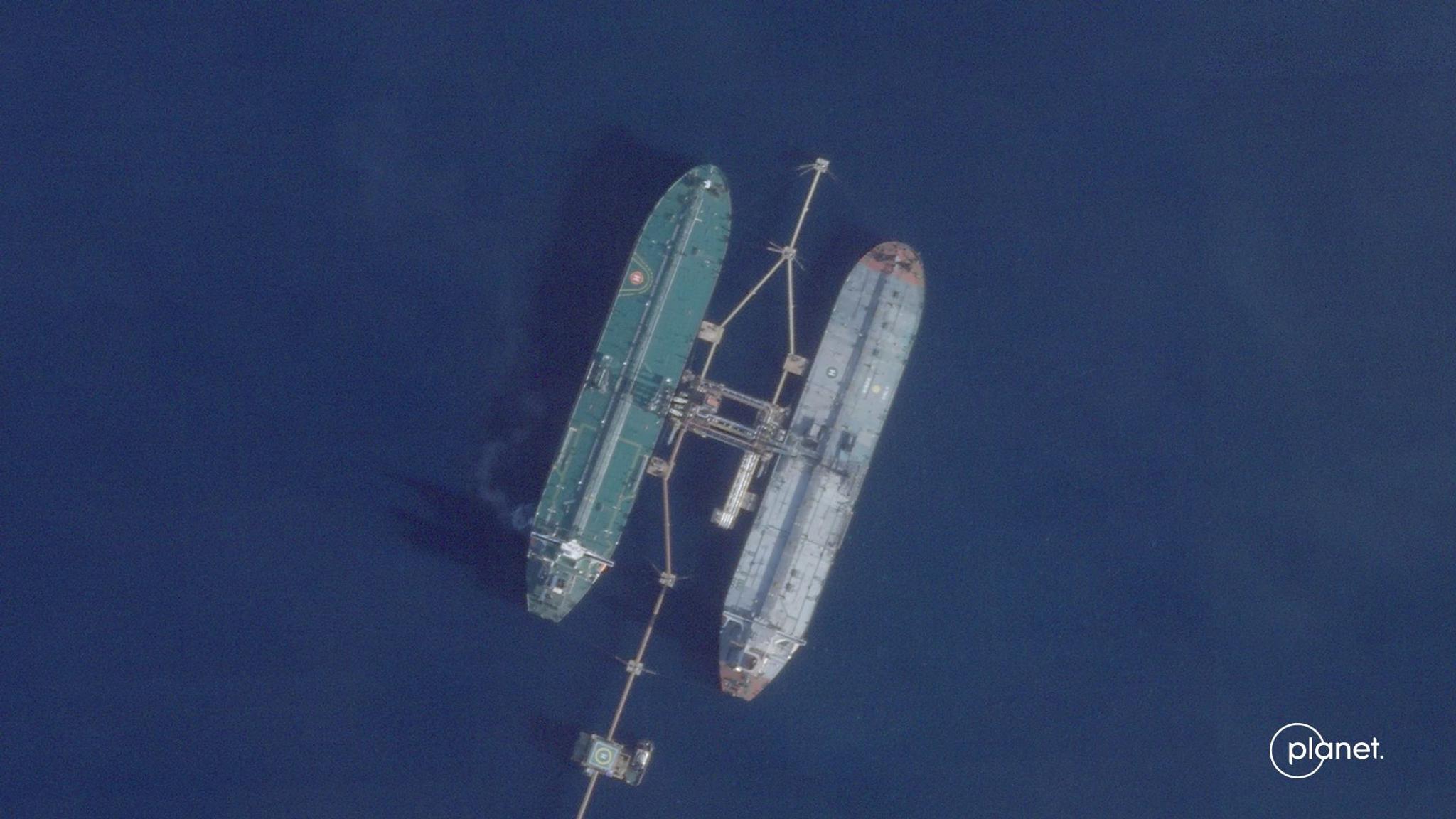
According to analysis of Planet data done by The New York Times, the oil tanker Skipper, seized by the U.S. for sanctions evasions, has faked its location multiple times.
The Problem: Traditional Maritime Monitoring Is too Passive and Easily Exploited
Traditional monitoring relies on voluntary automatic identification system (AIS) signals, but nefarious actors can easily turn off transponders or spoof their location to evade detection. AIS spoofing has increased over 200% since 2022. Other forms of monitoring, such as aircraft, patrol boats, and high-resolution satellites are costly to deploy and only effective when you already know where to look.
Now imagine if commercial operators, governments, and security agencies could automatically detect vessels trying to hide their location, anywhere within their area of interest – that’s the potential of the Planet Maritime Domain Awareness solution.
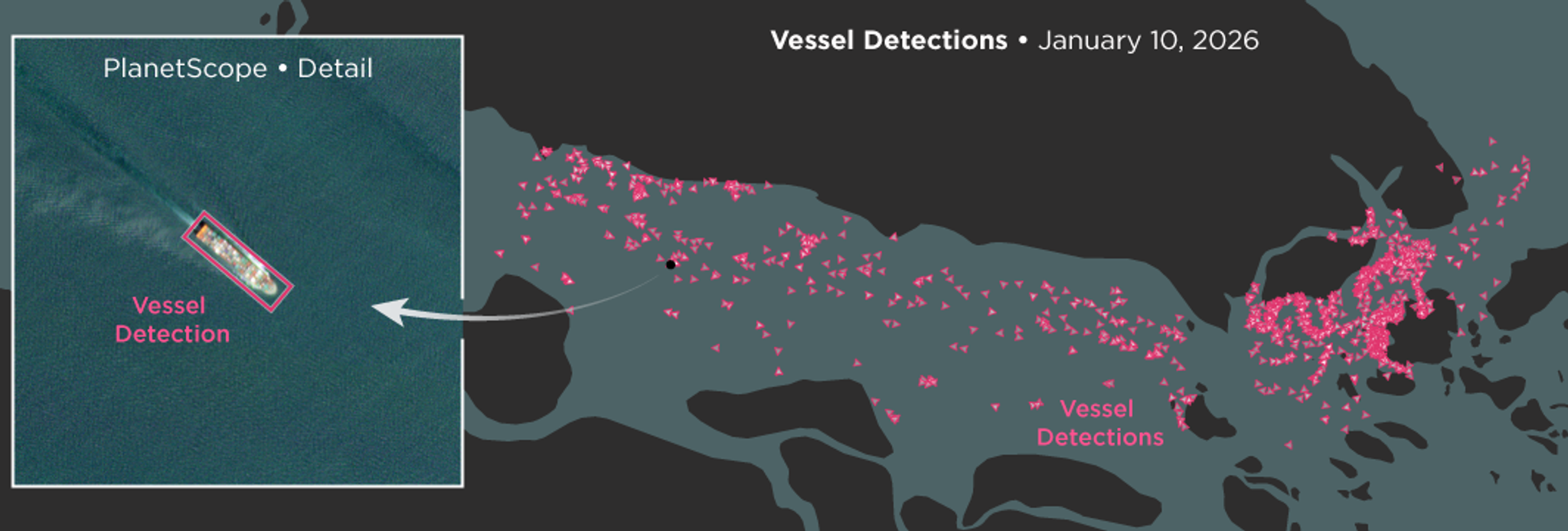
Planet's MDA solution leverages AI to automatically detect and categorize vessels in satellite imagery. The vessel detections shown here are in the Strait of Malacca on January 10, 2026.
The Proactive Approach: Satellite Monitoring With AI-Enabled Vessel Detection
The Planet Maritime Domain Awareness solution offers a modern approach to maritime intelligence by combining near-daily satellite monitoring with AI-enabled vessel detection and last-mile partner solutions, so that customers can:
- Spot what others miss with unmatched coverage and frequency over 20 million sq km of open water, covering strategic regions like the South China Sea, the Persian Gulf, and the Strait of Malacca.
- Detect dark vessels with unspoofable intelligence by leveraging electro-optical imagery to detect vessels regardless of their emission control (EMCON) posture or AIS status.
- Understand trends by analyzing an archive of historical satellite imagery.
- Empower faster response with unclassified, sharable data that’s easy to integrate with existing systems and workflows.
Loading Video...
The Planet Maritime Domain Awareness solution.
Reduce Risk by Removing Blind Spots
Planet is already helping customers in the U.S. Navy and National Geospatial Intelligence Agency expand their maritime domain awareness capabilities. By filling blind spots left by traditional monitoring, our modern approach to MDA empowers a range of commercial maritime and government stakeholders to reduce risk and make better decisions with more timely, reliable data.
- For commercial shipping, satellite monitoring enables dark vessel detection so that they can help identify suspicious behavior, address disruptions faster, and maintain sanctions compliance.
- For marine insurance, objective historical data about vessel patterns and incidents can be used to help detect evasive behavior, investigate claims, and price risk with confidence.
- For defense and intelligence agencies, faster indications and warnings based on objective, sharable, and unclassified data enable timely coordinated response to emerging threats.
Loading Video...
Port activity in Bandar Abbas, Iran.
How It Works: A Flexible Solution That Integrates With Your Tools and Workflows
The Planet Maritime Domain Awareness solution enables customers to combine the following components according to their needs:
- Broad area open-water monitoring. The PlanetScope® constellation delivers near-daily 3.7 m imagery over 20 million sq kms of open water, covering strategic regions like the South China Sea, the Persian Gulf, and high-risk corridors.
- Automated vessel detection. Planet Automated Vessel Detection feeds use deep learning to detect ship bunkering, identify and categorize vessels (cargo, tanker, military, etc.), and provide location, heading, and confidence scores.
- Advanced analysis with AIS data. The data API makes it easy to integrate vessel detections and imagery into existing MDA platforms, or into the MDA platform Theia (provided by Planet’s partner, SynMax), where it can be combined with AIS data to enable dark vessel detection, tracking of specific vessels, path prediction, and other advanced analyses.
Ready to Eliminate the Blind Spots in Your Maritime Picture?
Register for our upcoming Maritime Domain Awareness webinar to learn more about the solution and how it can help your organization detect (and mitigate) maritime threats before they escalate. Or, if you’d like to discuss bringing Planet Maritime Domain Awareness to your organization, reach out to our team for more information.
Ready to Get Started
Connect with a member of our Sales team. We'll help you find the right products and pricing for your needs.