
Objective, Automated, Assured: Introducing Planet Area Monitoring Service
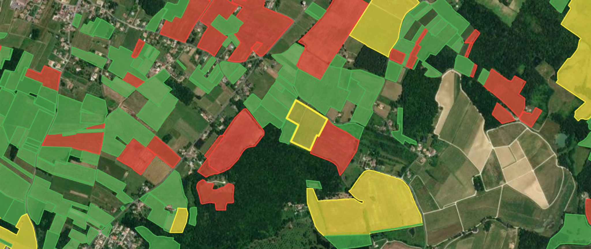
This illustration from the Area Monitoring Browser interface shows claimed crops colored red, yellow or green (the traffic light system), according to the assessment of whether their claim of permanent crop status is valid.
TechToday's agricultural compliance regulations require prompt, detailed verification across millions of hectares to meet strict regulatory deadlines. Conventional methods, that rely on manual supervision and on-site inspections, are simply too slow and costly to scale.
To address this, we developed Planet Area Monitoring Service (Planet AMS), a transparent, objective, and automated software solution. Planet AMS is designed to help agencies monitor, validate, and report on agriculture activity at the field level, to support policy-making and timely claim payments.
In our recent webinar, Agile EO: Introduction to Area Monitoring Service, we shared how our extensive data processing capabilities and application expertise converge in this powerful tool.
You can watch the full webinar now for a detailed look at the service. For an overview of how Planet AMS transforms agricultural monitoring, keep reading.
The Engine: Signals and Markers
The foundation of Planet AMS lies in combining vast amounts of satellite data with farmer claims and parcel boundaries. Here is an overview of the workflow:
1. Curated Data: Planet AMS leverages open-source Copernicus Sentinel data alongside high-cadence, high-resolution Analysis-Ready PlanetScope® data to ensure near-real-time, global coverage.
2. Signals: For each declared parcel, Planet AMS extracts a data time series (a "signal"), such as the Normalized Difference Vegetation Index (NDVI) and other remote sensing indices, plotting the crop's development over the growing season. This allows for instant comparison against local averages for the same crop type.
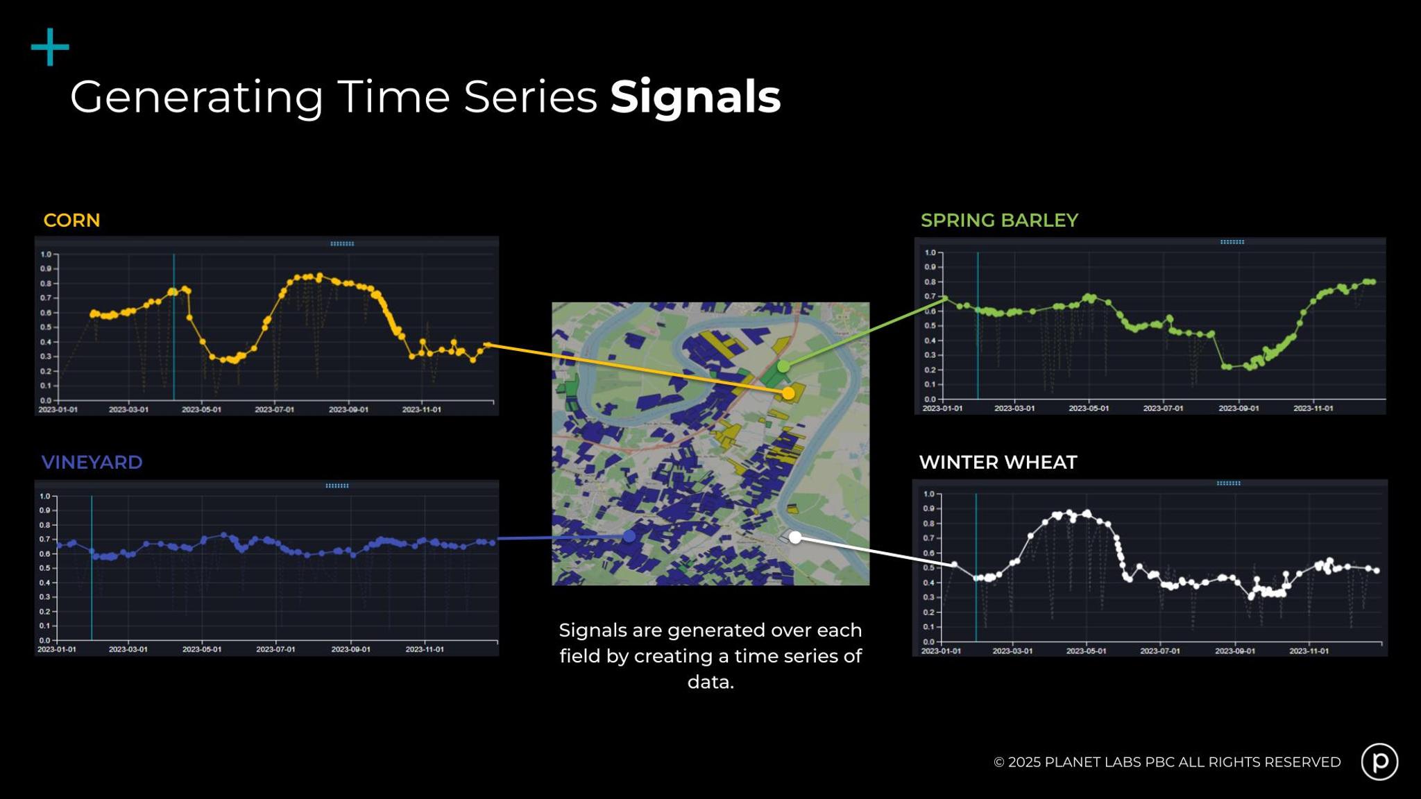
By combining vast amounts of satellite data with farmer claims and parcel boundaries, Planet AMS is able to plot the crop's development over the growing season, generating time series Signals.
3. Markers: These signals are then processed using AI and machine learning to generate derived products, or "markers," which provide specific insights, including:
- Crop and Land Use: Verifies if the claimed crop is consistent with local averages.
- Homogeneity: Checks for spatial variations within the field (e.g., weeds, trees, or non-agricultural elements).
- Activity detection: Identifies key events like bare soil, mowing, plowing, and harvesting, which is critical in ensuring regulation compliance.
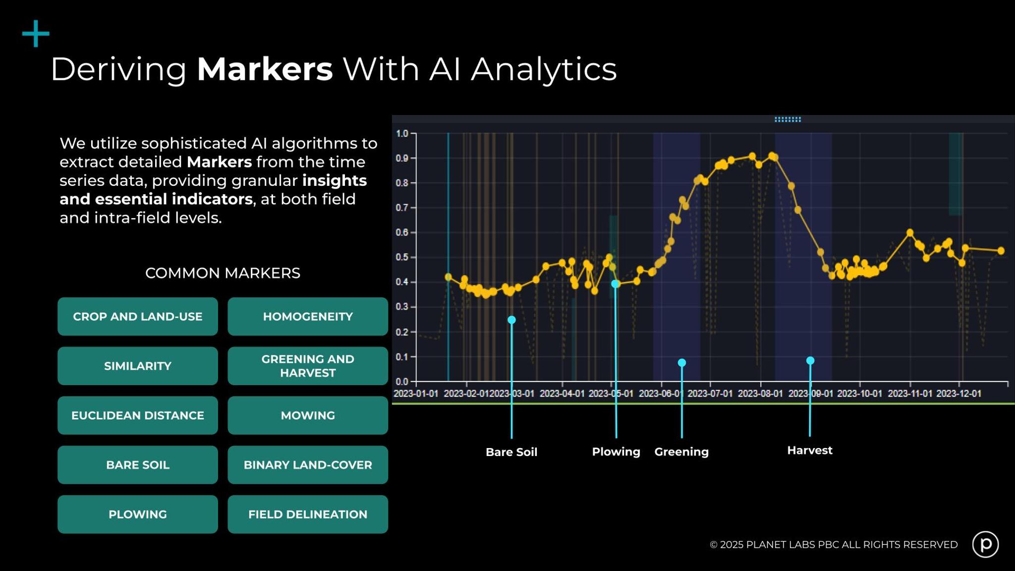
From Signals, we can derive specific events, or Markers, throughout the growing season, which helps verify if the claim is consistent with other crops in the area.
From Data to Decisions: The Traffic Light System
While signals and markers provide field-level context, the true power of Planet AMS is the ability to transform that data into actionable compliance decisions.
Planet AMS incorporates a customizable traffic light system that encodes a customer’s business rules in a decision tree, yielding three types of decisions:
- Green: There is nothing indicating that a payment/claim should be withheld.
- Red: A rule has likely been broken, allowing for immediate disallowance of the payment.
- Yellow: The signal is not clear, indicating the need for a human-in-the-loop review or further validation.
This traffic light approach drastically reduces the amount of expensive field inspection required. One example is with the yellow cases. Paying agencies can issue a request to the farmer for a geotagged photo that provides near-real-time, verified ground truth to finalize the claim decision.
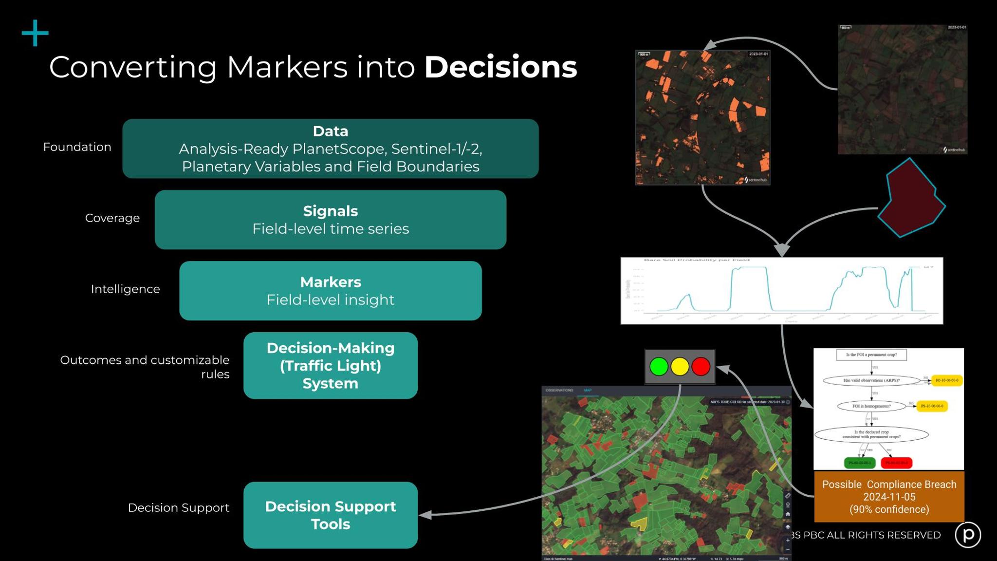
Lastly, you can use the Markers to inform your decision making via customizable rules and enact the traffic light system.
The Power of Precision: High-Resolution Data at Scale
While open data provides a valuable base, the integration of high-cadence PlanetScope data provides several benefits:
- Higher cadence: A near-daily scan means fewer data gaps in the time series to more accurately detect events like mowing or plowing, particularly in areas with persistent cloud cover.
- Enhanced spatial resolution: The precision of 3 meter resolution is crucial for monitoring smaller, irregularly shaped fields, ensuring full-pixel coverage is maintained to produce reliable statistics.
The Planet AMS infrastructure is continually evolving, with plans to incorporate Planetary Variables® — like Soil Water Content and Land Surface Temperature — to support further applications, including carbon markets and yield estimation.
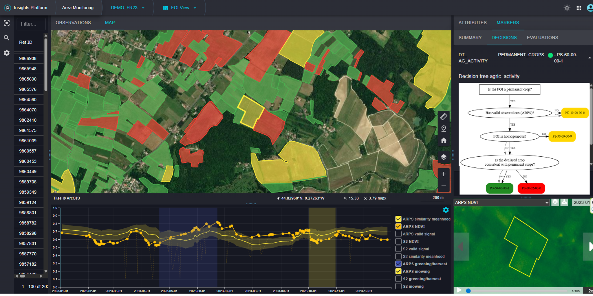
Claimed crops are colored red, yellow or green (the traffic-light system) in the Area Monitoring Browser interface, according to the assessment of whether their claim of permanent crop status is valid.
Ready to Automate Your Land Monitoring?
If your organization is looking to replace slow, manual inspection with objective, automated, and assured land monitoring, Planet AMS offers a proven path to operational efficiency and cost reduction.
Watch the complete Introduction to Area Monitoring Service webinar now! Or if you’d like to discuss the possibility of Planet Area Monitoring Service for your use case, reach out to our team for more information.
Ready to Get Started
Connect with a member of our Sales team. We'll help you find the right products and pricing for your needs.