
Announcing the Next Wave of Project Centinela Biodiversity Sites
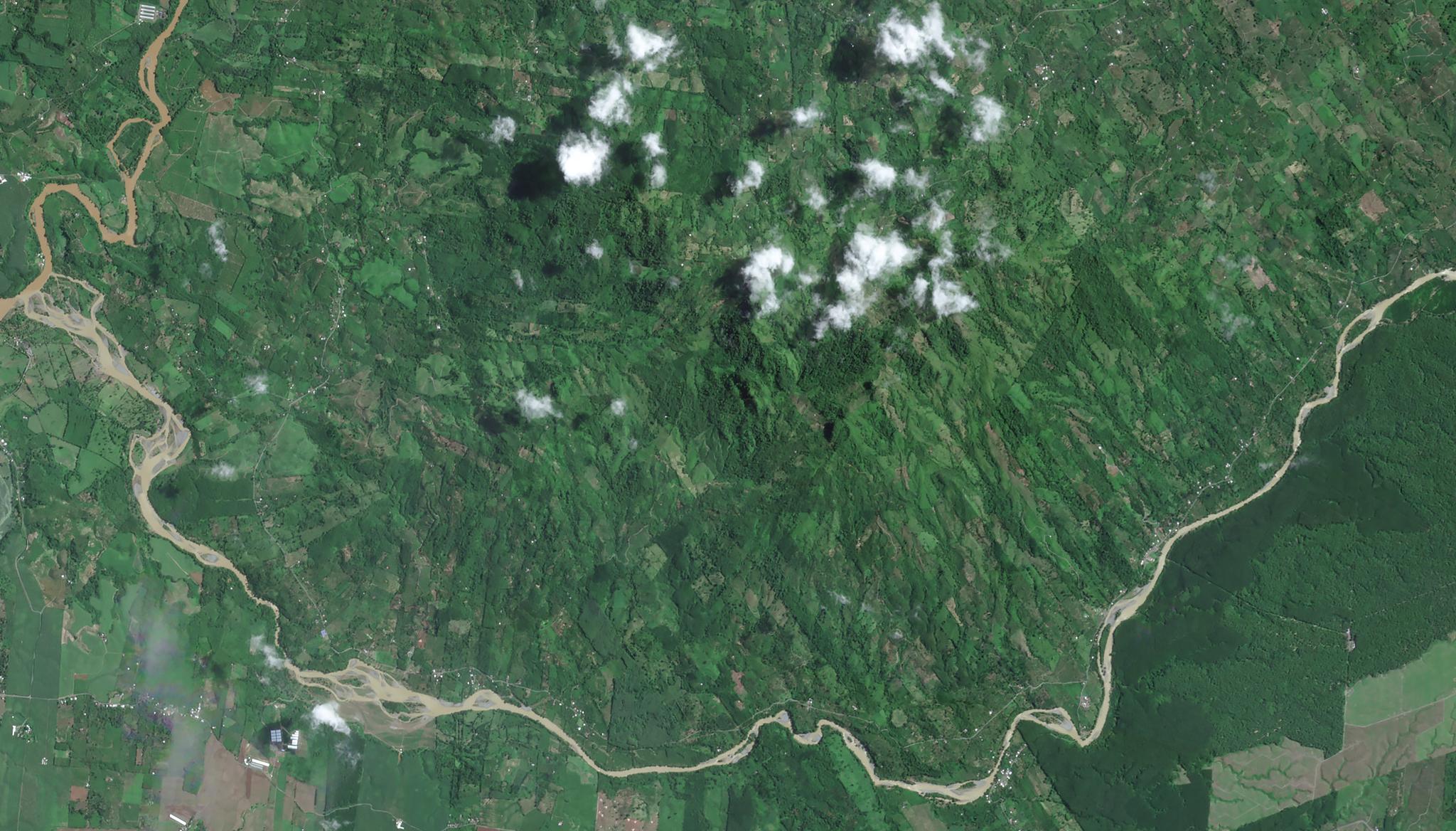
PlanetScope image of a portion of el Centinela Mountain in Ecuador, captured April 29, 2023. © 2023 Planet Labs PBC. All Rights Reserved.
NewsCoauthored by Amy Rosenthal and Seamus Lombardo
Planet satellites capture images of all of Earth’s landmass and coastal areas on a near-daily basis, making change visible, accessible and actionable. Combining this satellite imagery with additional datastreams has also enabled the creation of our sophisticated analysis-ready Planetary Variables, analytic feeds that help track and understand changing conditions on the surface of the Earth — ranging from Soil Moisture Content to Forest Carbon. Today, you can access this eye-opening data through Planet Insights Platform, which allows users to manage collections of geospatial data and analyze spectral information and time series trends all in one cloud-based interface.
As we’ve been making these technical innovations, we’ve kept an eye on our mission: using space to help life on Earth. In late 2024, Planet launched a new impact program called Project Centinela to help leading scientists, conservationists, and stewards monitor and safeguard 50 of the world’s vulnerable biodiversity sites. Project Centinela provides a three-year “biodiversity subscription” of Planet imagery and analytics for those on the frontlines of conservation around the world. We consider the program a core element of Planet’s contributions to the Kunming-Montreal Global Biodiversity Framework, and an initiative that helps us fulfill our Public Benefit Corporation purpose.
And, excitingly, we are discovering that Planet’s unique data and analytics have a significant role to play in conservation planning, priority-setting, monitoring, and reporting. These applications support on-the-ground stewardship and conservation management, and they also contribute to large-scale policy and program design and evaluation undertaken by government agencies, philanthropies, and multilateral institutions. These efforts are yielding more tailored tools and methods that illuminate and help improve biodiversity outcomes, natural resource management, and responsible development planning.
We inaugurated the program with an initial set of ten sites in 2024, and now we’re proud to welcome another five sites into the program.
Sacred Headwaters, Ecuador
The Indigenous Achuar, Shuar, Kichwa, Sapara, Shiwiar, Andwas, and Siekopai peoples have long stewarded the intact primary forests, rivers, and wetlands of the sacred headwaters region in Amazonian Ecuador, and they are principal architects of restoration efforts on degraded and productive lands. This site is home to an array of flora and fauna, including numerous endemic and endangered species, like the giant otter, jaguar, wattled curassow, and harpy eagle.
Yet the region faces severe threats from expanding roads, fossil fuel extraction, mining, logging, and agricultural activities, jeopardizing both the intricate ecosystems and Indigenous lifeways. In partnership with these Indigenous nations, Fundación Pachamama, Amazon Sacred Headwaters, and Regen Network have established a comprehensive conservation action plan, underpinned by biocultural stewardship principles and territorial sovereignty. They will use Planet imagery and analytics to monitor deforestation, support indigenous conservation efforts, and pioneer biocultural jaguar stewardship units as a new financial model for conservation. The effort will combine remote sensing and on-the-ground, community-led data collection and validation methods, producing biodiversity credits tokenized with blockchain technology and securing effective conservation and sovereignty for the peoples who have long called the region home.
Upemba National Park, The Democratic Republic of the Congo
Upemba National Park — a mix of savanna, forest, and grassland in southern Democratic Republic of the Congo — was established as one of the country's richest biodiversity areas and first protected areas, recognized as a global Wetland of International Importance pursuant to the Ramsar Convention.
The Forgotten Parks Foundation, in partnership with Institut Congolais pour la Conservation de la Nature and Wageningen University and Research, is acting to restore this natural treasure while supporting development goals of surrounding communities. The park has suffered in recent decades from civil conflict, hard-rock mining, and widespread poaching. Despite these challenges, Upemba is undergoing a remarkable rebirth. It remains home to the DRC’s only population of free-roaming zebras and supports a vital community of savanna elephants.
Recent conservation gains include the increase in zebra populations and the groundbreaking rediscovery of the Upemba lechwe, a semi-aquatic antelope thought to be extinct. By adding Planet data, the site team will create a baseline assessment of habitat condition over 13,470 sq km, which they’ll use to generate machine learning models to track threats to the park’s precious wildlife and decipher the landscape's complexity. This data will feed a monitoring system directing park management and ranger patrols, community-based programming and restoration, and effective allocation of limited resources to safeguard Upemba’s biodiversity for future generations.
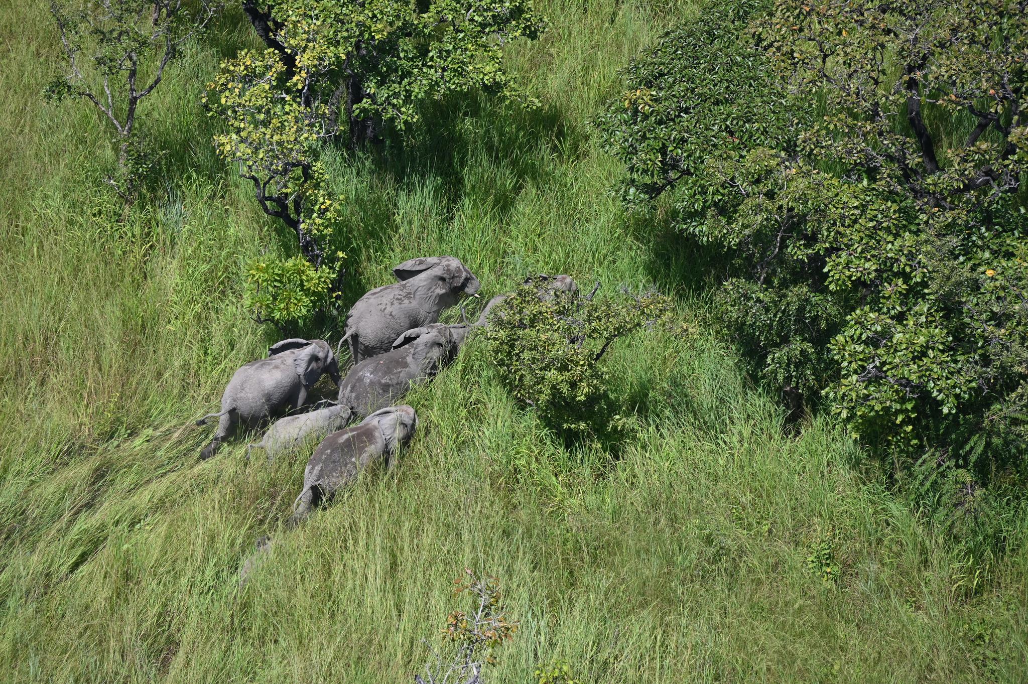
Elephants in Upemba National Park. Photo by Chris Thouless of Save the Elephant, via Forgotten Parks Foundation.
Sky Aelans, Solomon Islands
The Sky Aelans (“Sky Islands”) of the Solomon Islands represent irreplaceable ecosystems, filled with unique species, found nowhere else on Earth. They are surrounded by vibrant and diverse mangroves that protect the islands from sea level rise and ocean storms, which also serve as nursery habitat for fish and crustaceans that are a major source of food and livelihoods for local Solomon Islanders.
On the islands of Malaita, Central, and Guadalcanal, Indigenous communities have stewarded these lands and waters for thousands of years. Today, they are threatened by outsiders, who illegally cut and sell old growth trees, rip away the protective mangroves, pump out gold from rivers, and build secret roads endangering forests teeming with life, including the critically endangered Guadalcanal Monkey-faced Bat, endemic Guadalcanal Boobook owl, rare Malaita White-eye bird, and endemic Malaita Dwarf Kingfisher.
The partners for this vulnerable high-biodiversity site represent the resources (Nia Tero), tech knowhow (Conservation Metrics, Imazon), and Indigenous expertise and stewardship (Islands Knowledge Institute, Mai Maasina Greenbelt) crucial to successful, durable, community-rooted conservation. They are committed to blending traditional knowledge with cutting-edge tools and technologies to ensure the effective protection of Solomon Islands’ lands and waters. By integrating advanced systems and modern methodologies, local leaders aim to enhance their capacity to counteract external pressures while supporting their people in engaging with these tools in ways that are innovative, practical, and meaningful. Together, the site team brings a unified approach to safeguarding the Sky Aelans biodiversity and cultural heritage through a dedicated “Guardian Connector” platform that secures Indigenous data sovereignty while delivering efficient pathways for coordination on conservation enforcement and actions.
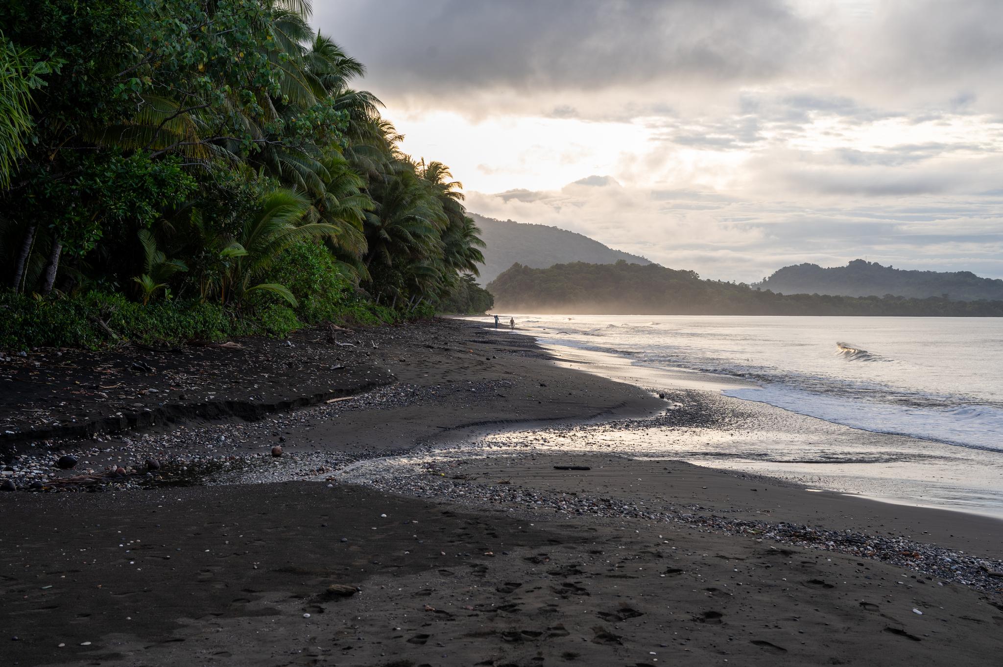
Malaita, Solomon Islands. Photo by Rudo Kemper.
Atlantic Forest, Brazil
The Atlantic Forest is a global biodiversity hotspot, teeming with life and renowned for its exceptionally high levels of endemism, harboring species unique to this region, like the golden lion tamarin, red-billed curassow, and rare orchids. Stretching southward along Brazil’s Atlantic coast and inland, the ecoregion has been devastated by deforestation and fragmentation. Today, only about 17% remains, and remnant intact areas are under immense pressure from expanding infrastructure, agriculture, and urban areas.
C3 Ambiental, and its partners Federal University of ABC and Spotsat, have teamed up to try to reverse that trend by working locally with small landowners to replant native forests, harness incentives for their conservation and restoration efforts, and coordinate across many land parcels to scale conservation outcomes and contribute to a regional green economy. In this Project Centinela site in Apiai and Lagoinha in southeastern Brazil, they will integrate Planet data into their on-the-ground biodiversity monitoring and community engagement efforts, monitoring habitat for threatened jaguar, araponga, and other endemic species. The results will demonstrate the contributions of Planet data for monitoring and validating restoration success under emerging nature stewardship methodologies.
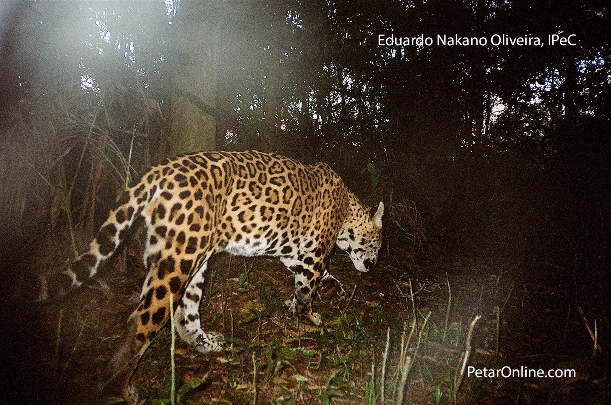
A jaguar in the Atlantic Forest. Photo by Eduardo Nakano Oliveira, via C3 Ambiental.
Maya Forest Mosaic, Belize
This mosaic of protected and productive landscapes in Belize is a significant global biodiversity hotspot. It provides habitat for over 118 globally threatened species, including the critically endangered Central American river turtle, the yellow-headed parrot, and the Baird’s tapir. The region serves as one of the last strongholds for several at-risk species, including the Yucatán black howler monkey and the white-lipped peccary.
Comprising protected areas, productive areas, major rivers, and dozens of permanent sample plots, the Maya Forest Mosaic is remarkably diverse. However, this natural and cultural heritage is under mounting pressure from recurrent and increasingly severe wildfires, expanding agricultural frontiers, extensive logging, and road development that fragments habitats and weakens ecological connectivity. Long-term biodiversity monitoring has revealed a decline in bird populations and pollinators, driven by wildfires, land clearing, and pesticide exposure.
Today, a collaborative initiative between place-based Belize Maya Forest Trust, Wildlife Conservation Society, and Belize Forest Department is actively monitoring these land use changes to assess ecosystem health, engage stakeholders, and develop effective conservation strategies and action plans that support both national and international commitments, including Belize’s Nationally Determined Contribution (NDC) targets under the Paris Agreement. Their distinctive local-to-national approach integrates scientific research and capacity-building within a framework for effective stewardship and enforcement, positioning it as a potential model for world-leading conservation practices. As a Project Centinela site, the initiative will leverage Planet data to strengthen Belize’s National Forest Monitoring System and management strategies, enabling the tracking of land use changes, prediction of high-risk areas for proactive intervention, monitoring of habitat recovery to improve restoration planning, and the design of wildlife corridors for adaptive landscape management.
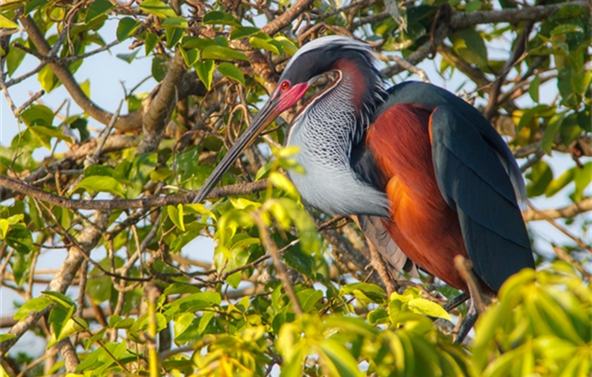
Agami heron in the Maya Forest Corridor. Photo from Wildlife Conservation Society (WCS).
These Project Centinela sites span multiple continents and ecosystem types — from Pacific Island mangroves to Amazonian rainforest and African savanna. The teams in these sites are using Planet data to inform a range of decisions, from managing protected areas to developing biodiversity credits to safeguarding sacred sites. These projects combine the biodiversity expertise of these pioneering organizations with AI methods, cloud-based platforms, and blockchain technology.
All of these threads come together toward the common goal of Project Centinela: protecting the world’s biodiversity for the benefit of communities and the world. Planet continues to accept expressions of interest from teams with a long-term say or a stake in vulnerable, high-biodiversity sites around the world: apply today!
Ready to Get Started
Connect with a member of our Sales team. We'll help you find the right products and pricing for your needs.