
Capturing Key Port Sudan Imagery Across Planet's Layered Capabilities
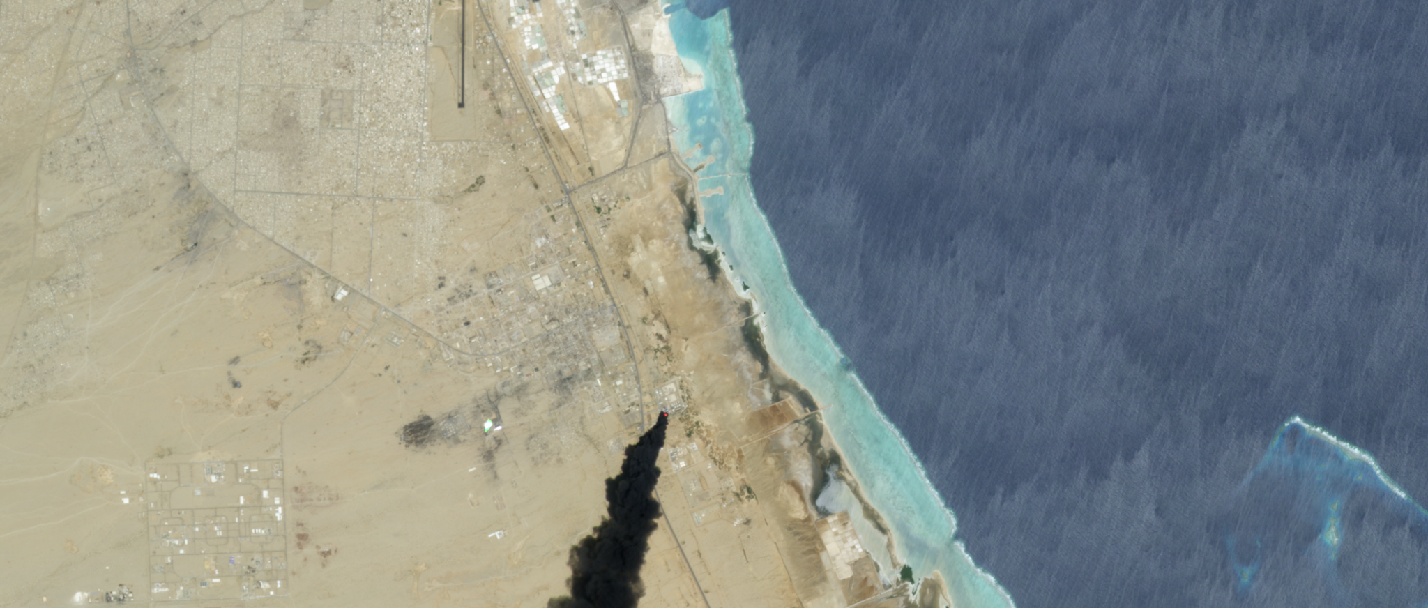
On May 6, 2025, Port Sudan, a Red Sea city serving as a refuge in Sudan's two-year war, was hit by paramilitary drones strikes on key targets, including the airport, port, and critical fuel infrastructure, sending plumes of thick black smoke into the sky.
Planet satellites swiftly captured imagery of the Port Sudan drone strike, providing an objective overhead view of the unfolding event. Leveraging its hybrid constellation, Planet documented the event across three unique classes of satellite, providing rich layers of imagery and insights. This data, combined with machine learning-powered object detection, can deliver a more complete understanding of such incidents. With the world’s largest commercial Earth observation satellite fleet and vast data stack, Planet can provide broad scope, essential context, and crucial insights into relevant activities before, during and after events.
Broad-area monitoring provides the foundation needed to stay abreast of dynamic situations like the Port Sudan attacks. This is where PlanetScope excels. With its constellation of Doves and SuperDoves, Planet’s daily scan of the Earth’s landmass has helped collect, on average, over 3,000 images for every point around the world at 3.7 meter resolution. This persistent view can provide an invaluable baseline, establishing normal patterns and making anomaly detection possible.
In the case of Port Sudan, PlanetScope imagery taken ahead of the reported May 6th and 7th, 2025, drone strikes shows typical port activity and urban patterns. Crucially, it was this daily coverage that helped deliver the first visual confirmation of the event's aftermath, capturing the initial smoke plumes and signs of disruption. This "always-on" capability can help record even unexpected events, providing the catalyst for deeper investigation and a foundational dataset for seeing change over time.
PlanetScope Imagery from May 3 to May 11, 2025 showing the evolution of the situation over Port Sudan
Beyond visual analysis of the immediate physical damage, understanding the broader context of maritime activity can be crucial. Planet Maritime Domain Awareness solutions, powered by PlanetScope imagery, enable identification and classification of vessels in any given area of interest. Vessel counts are then analyzed to detect patterns and behaviors over extensive areas and timeframes. For an active port city like Port Sudan, monitoring vessel traffic — such as the number of ships at anchor or moving in and out of the port in the weeks leading up to and following the drone strikes (for instance, between late April and mid-May 2025) — reveals noteworthy shifts in maritime behavior.
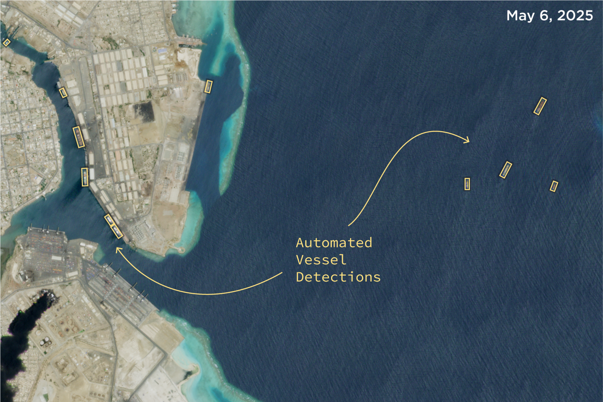
Planet is able to detect and count vessels over AOIs leveraging its PlanetScope imagery, as noted here in the Port Sudan incident.
These analyses, run across massive areas of ocean imagery, revealed significant deviations from normal shipping activity and provided a critical "tip." These types of insights can help expand the operational picture by prompting analysts to action and “cue” more detailed surveillance from Planet high-resolution satellites.
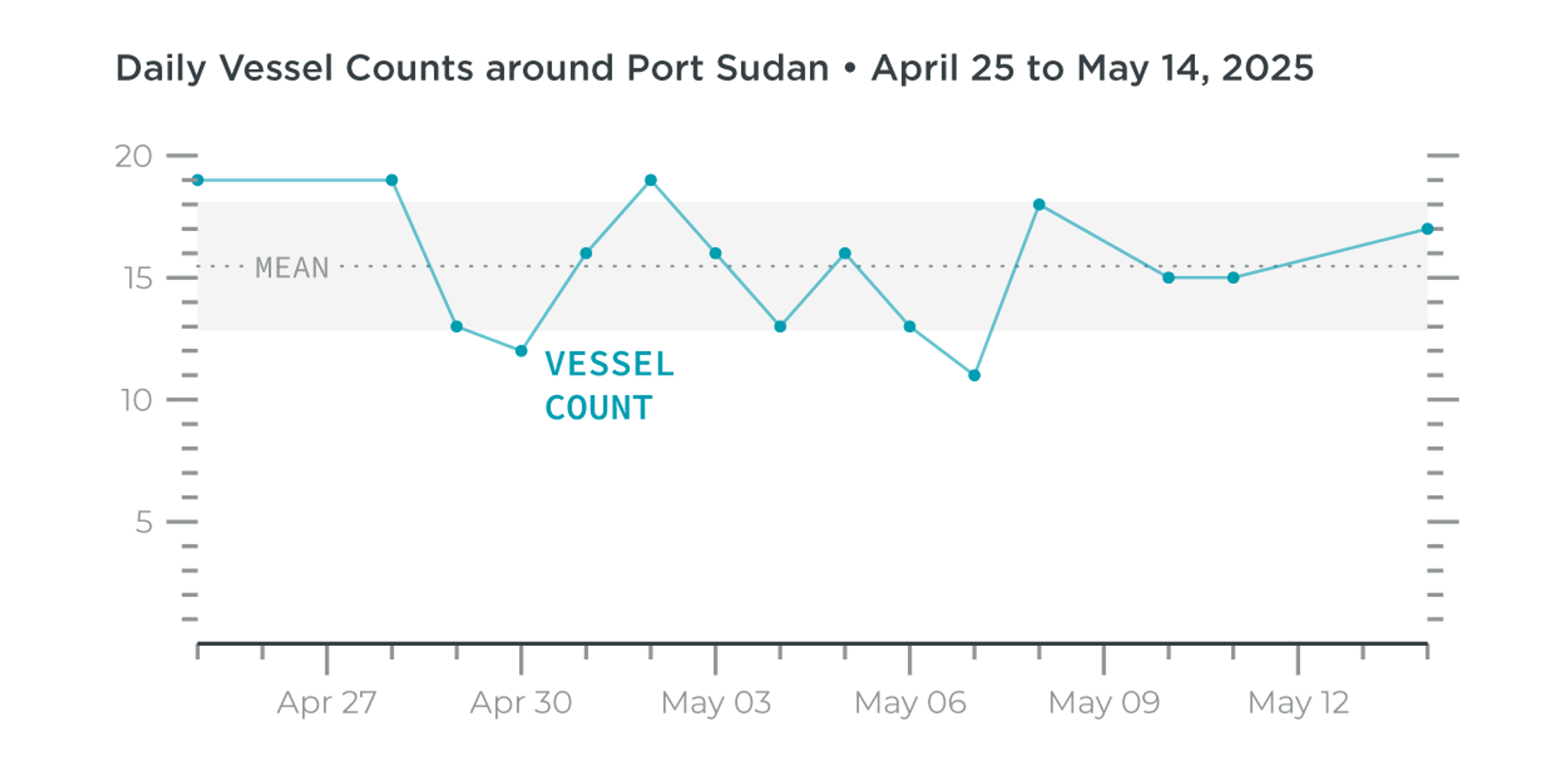
In this case, vessel counts were significantly below average on the day after the drone strike, the lowest count in the 18-day window before and after the attack.
Initial alerts like this from Vessel Detection or even from visual inspection of imagery can be key flags for areas of interest. They can then be further explored with imagery from Planet high-resolution tasking satellites, SkySat and the newly introduced Pelican-2.
In this instance, SkySat delivered high-resolution imagery over Port Sudan on May 6th and 7th, 2025, capturing the distinct smoke plumes from the attacked fuel facilities and offering clear views of the affected areas. Planet’s next-generation Pelican spacecraft was also tasked over Port Sudan on May 7th, demonstrating the value of repeat, intraday revisits, improved optics, and an enhanced spectral range. Imagery of the Strategic Petroleum Reserve from May 6th to May 7th also shows the evolution of the triggered fire as it continued to spread between tanks.
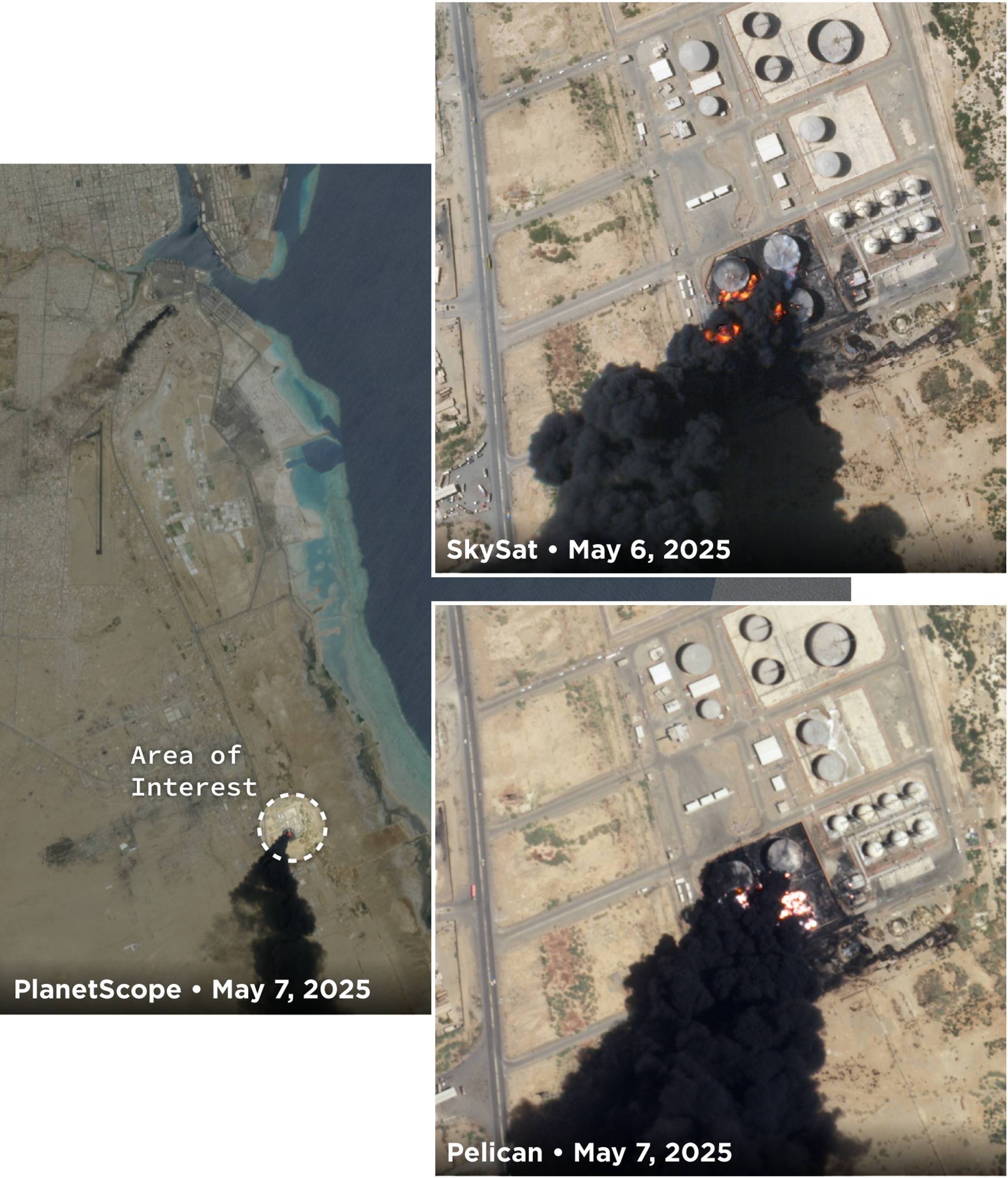
Imagery from Strategic Petroleum Reserve showing evolution of damage from May 6th to May 7th, 2025.
Looking at intraday revisits, May 7th imagery captured of the Bulk Product Depot near Port Sudan provides additional detail. The Pelican image, captured around 8:40 am local time, shows a small plume near damaged tanks and an oil spill visible from the tanks. At around 11:48 am, a revisit from SkySat shows that the spilled oil has ignited and the fire has spread farther throughout the depot.
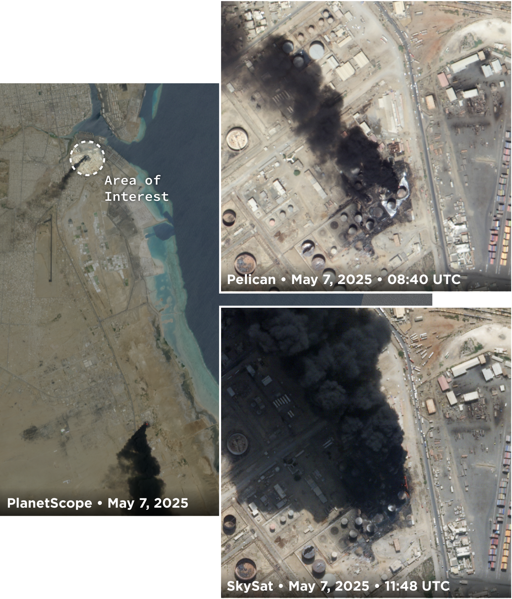
Imagery from Port Sudan Bulk Product Depot showing the evolution of damage and fire intensity from early to mid-morning on May 7th, 2025.
In addition to being able to monitor the evolution of events, Planet’s imagery also allows observations of the patterns of nearby daily life, like the below fuel station and bus stop north of the Port Sudan Bulk Products Depot.
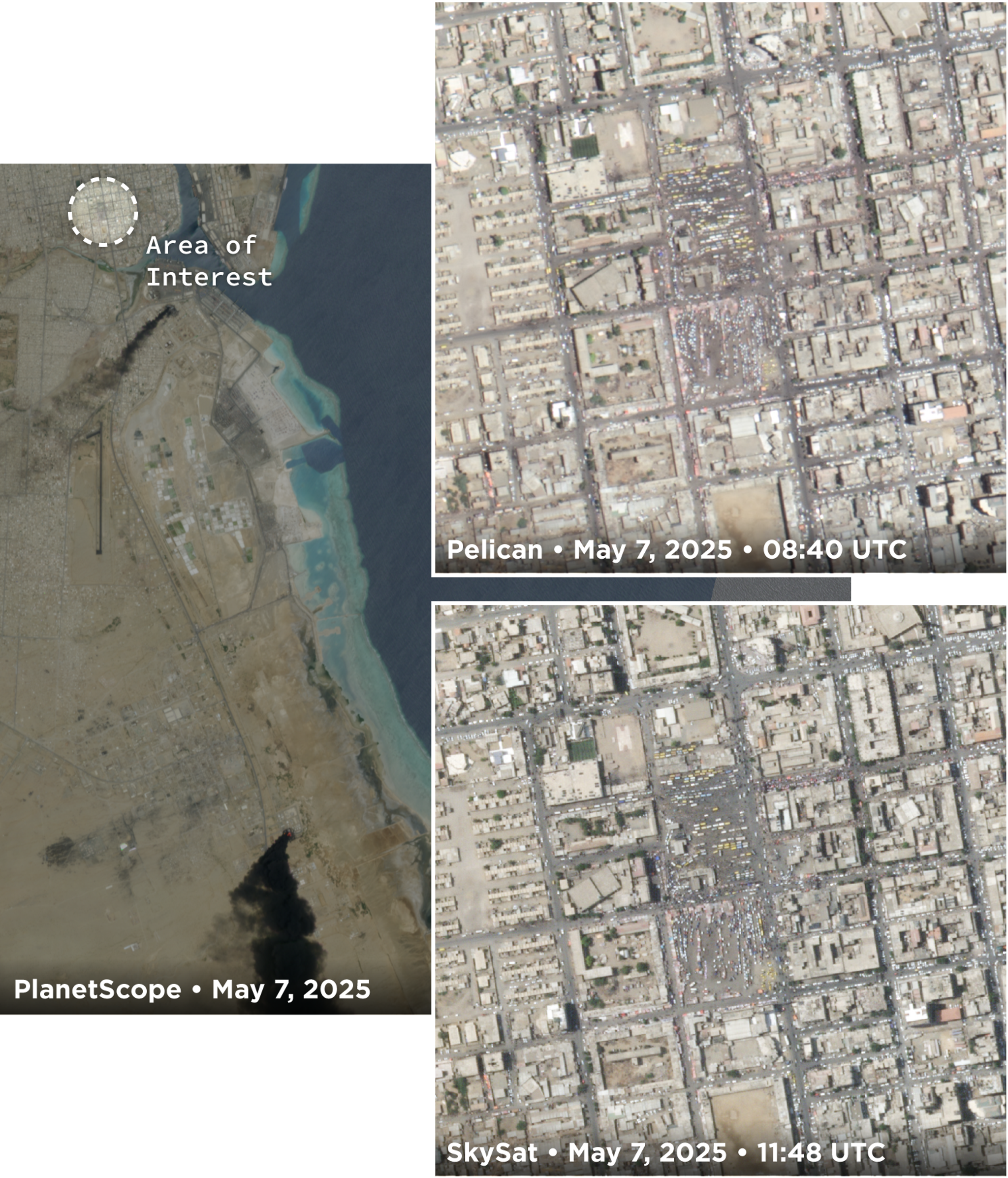
Imagery of a fuel station and bus stop north of the Bulk Products Depot showing human activity patterns as events unfold.
Planet’s unmatched Earth Observation constellation empowers users to monitor events as they happen — with exceptional temporal frequency and spatial precision. Solutions built on Planet’s imagery benefit from the depth, consistency, and reliability of its imagery, enabling customers to make informed, timely decisions.
The ongoing implementation and expansion of Planet Tanager and Pelican constellations can also further expand what’s possible by unlocking new levels of detail and responsiveness. With a unified and seamless product experience, Planet makes it easy to harness the power of hundreds of satellites — delivering industry-leading revisit rates, high-resolution imagery, and advanced spectral capabilities.
Ready to Get Started
Connect with a member of our Sales team. We'll help you find the right products and pricing for your needs.