
Celebrating One Year of Tanager-1
One year ago, we launched Tanager-1, our first hyperspectral satellite. As the first commercial satellite with a methane minimum detection limit below 100 kg/hr, Tanager-1’s launch was a significant step forward for remote sensing tech. As we celebrate this milestone, we wanted to take a moment to reflect on the incredible people and organizations that helped make the launch possible – in particular, Carbon Mapper, our partners at SpaceX, and, of course, the fantastic Tanager team right here at Planet. Read on to learn more about how this launch was made possible, and all that the Tanager teams have accomplished since last August.
Getting to Launch
The journey to Tanager began in April 2021. Led by the nonprofit Carbon Mapper, a first-of-its-kind, philanthropically-funded, public-private coalition of entities with expertise across technology, science, engineering, government, and policy was established with the goal of collecting high quality hyperspectral data to identify and quantify point source methane emissions.
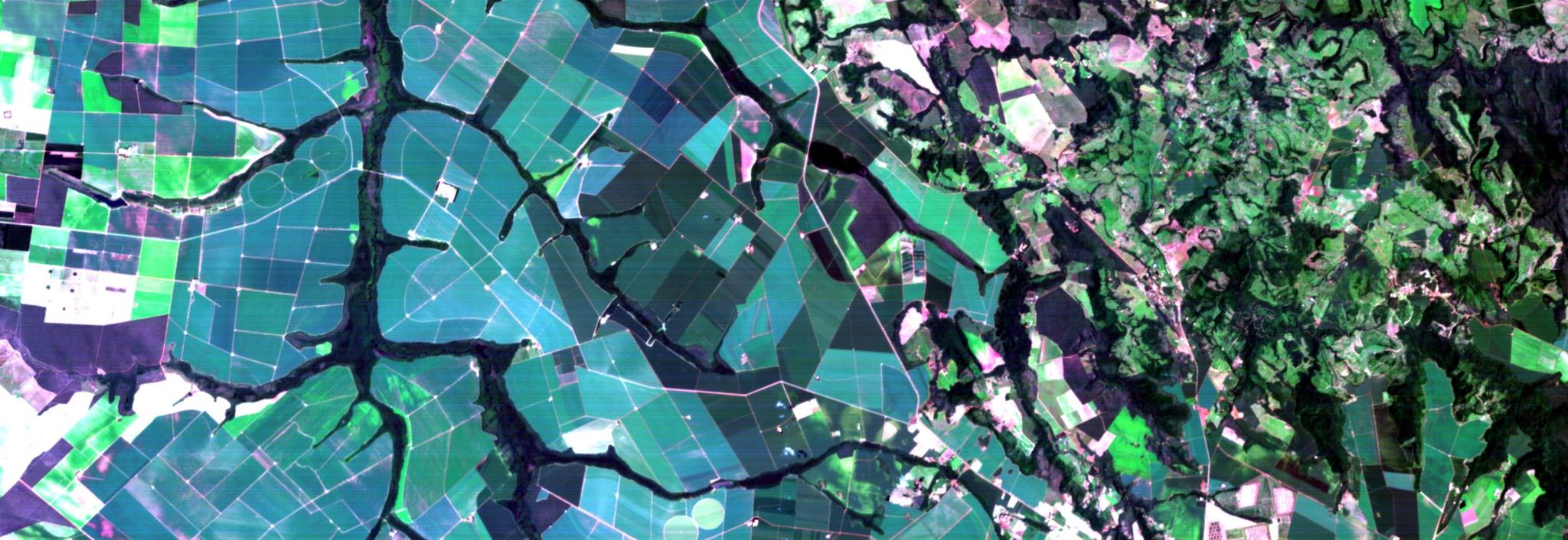
An example of a mitigation opportunity near Rio de Janeiro, Brazil, where Carbon Mapper methane detections from Planet’s Tanager-1 satellite show a large plume of methane from the Seropédica landfill on Sept. 29, with an estimated preliminary emissions rate of 2,836 kilograms per hour.
The following September, Planet announced its plan to build hyperspectral satellites to fulfill this vision. When deciding what to name our new constellation, we wanted to convey what the satellite was capable of while staying true to Planet traditions and choosing a bird of peace. We landed on ‘Tanager’ – the family of vividly colored birds native to Central and South America. Evoking these birds’ colorful makeup emphasized Tanager’s unique ability to image across a multitude of spectral bands, and perfectly encapsulates its vibrancy.

A green-headed Tanager, native to Brazil, Paraguay, and northeast Argentina. Photo credit: American Bird Conservancy
Tanager-1 is the first of four hyperspectral satellites being developed by Planet and NASA’s Jet Propulsion Laboratory through the coalition. At the core of Tanager-1’s advanced capabilities is the Dyson imaging spectrometer technology pioneered by NASA JPL. In addition to its successful launch and gathering of hyperspectral imagery, Tanager-1 is also now providing methane data to the state of California as part of the California Air Resource Board’s (CARB) California Satellite Methane Project (CalSMP). This partnership with the state is an important demonstration of how effective policymaking can bring together commercial innovation and government-funded research to drive impactful programs.
Tanager So Far
Over the past year, the Tanager mission has helped map, track, and quantify point source methane and CO2 emissions from orbit, making the invisible visible. To date, Tanager has detected more than 5,500 plumes across nearly 3,200 sources. Tanager’s advanced hyperspectral imaging capabilities have unlocked fundamentally new dimensions of Earth observation for Planet and our partners like Carbon Mapper. Tanager’s unique sensor package is tailored to meet the needs of an ever-changing world: hyperspectral monitoring allows for rapid detection of shifting conditions across massive scales, from wildfires to droughts to methane leaks. We’re deeply proud to be part of such an impactful and transformative partnership – and are eager for what’s yet to come.
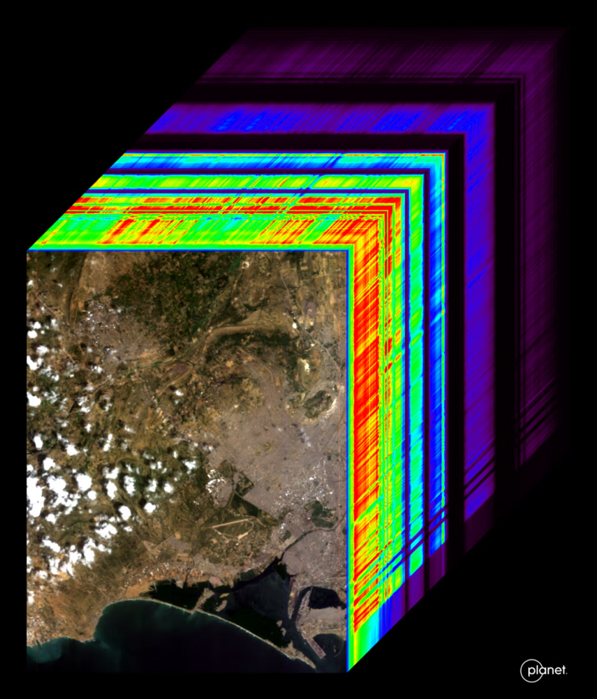
A hypercube visualizing the range of wavelengths collected by Tanager. In the lower left is a visible-light image of Karachi, Pakistan collected on September 19th, 2024. Up and to the right is a cross section of all the bands collected by Tanager spanning from 400 - 2500 nm.
With over 400 spectral bands and 30-meter spatial resolution, Tanager-1’s next-generation hyperspectral capabilities represent the cutting edge of Earth observation technology. Tanager-1 can image all wavelengths from ~400 - 2500 nanometers simultaneously, providing a comprehensive, multi-faceted dataset. This powerful capability produces imagery that supports diverse uses, ranging from methane and carbon dioxide emission detection to biodiversity and vegetation monitoring.
Tanager-1’s success is a powerful demonstration of how public-private partnerships can accelerate solutions to pressing global challenges. The Carbon Mapper Coalition unites organizations across commercial tech, philanthropy, and government to push the bounds of Earth observation. From the development of NASA JPL’s state-of-the-art imaging spectrometer to the use of Planet’s versatile smallsat bus, the mission exemplifies how shared vision, resources, and expertise can facilitate progress towards greater transparency and accountability for industry and regulators alike.
By the Numbers
Over the course of Tanager’s first year, together we have:
- Captured first light images over Karachi, Pakistan, on September 19, 2024, delivering rich spectral data across multiple wavelength ranges.
- Detected and quantified our first methane plume within 12 hours of First Light.
- Enabled multiple confirmed detections of methane and CO2 plumes in just over a month after launch.
- Carbon Mapper has detected, quantified, and published over 5,500 methane and CO2 plume detections based on insights gleaned from the data.
- Expanded the satellite’s imaging capacity to bring down hundreds of thousands of square-kilometers per day via hundreds of collections.
- Logged over 300 emissions events across six continents in Carbon Mapper’s data portal.
- Provided methane detection to support global mitigation efforts.
- Been selected as the primary subcontractor for the California Air Resource Board’s (CARB) California Satellite Methane Project (CalSMP), a $95M multi-year contract.
- Provided over 50 hyperspectral datasets for public use under a CC BY license on Planet’s Open Data STAC (SpatioTemporal Asset Catalog).
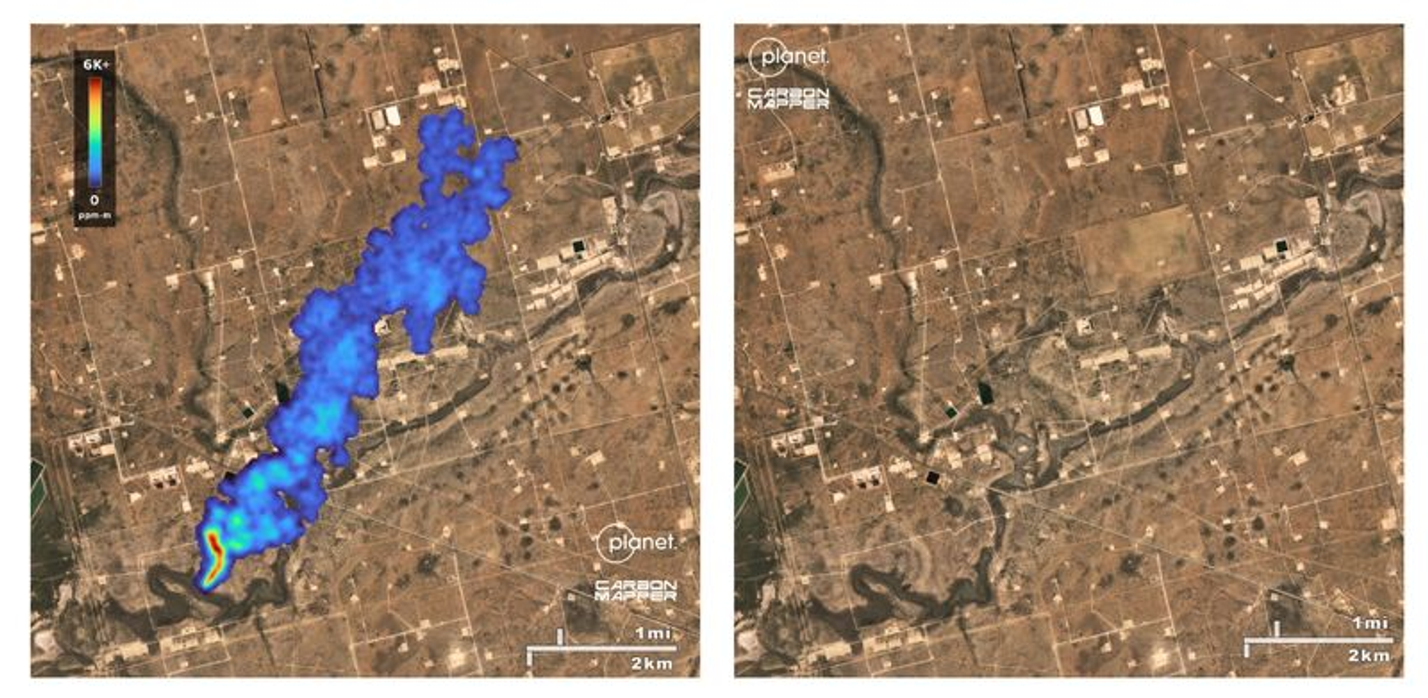
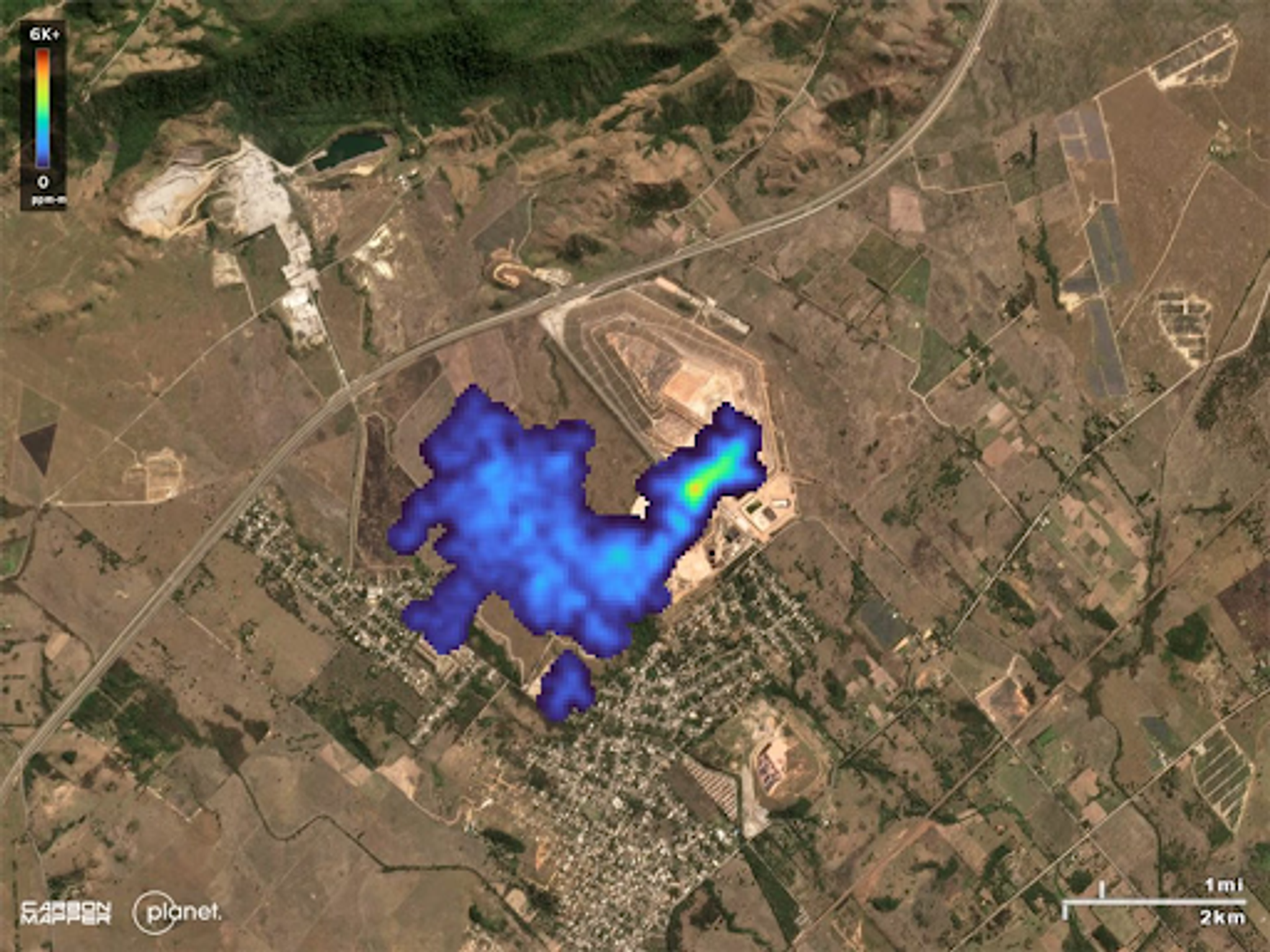
Left - a large methane plume from a leaking oil and gas pipeline was detected in the Texas Permian Basin from Tanager-1 data on Oct. 9. After being shared with federal and state agencies, the leak was voluntarily fixed by the operator. Right - a subsequent Tanager observation on Oct. 24 detected no methane.
Making It All Possible
We’re so proud of what this mission has achieved so far, and deeply grateful to our partners, customers, and the remarkable Tanager team for helping make Tanager a reality. In addition to the Carbon Mapper Coalition and SpaceX, we especially want to thank Planet’s Tanager team, including Amber McCullum, Technical Program Manager, Hyperspectral in Mission Enablement; Keely Roth, Lead Hyperspectral Scientist; Trevor McDonald, Senior Product Manager, Hyperspectral; Minh Radel, Engineering Director, Hyperspectral; Lisa Donahue, Engineering Director; Geert Barentsen, Senior Software Engineer; Malkam Goldstein, Spacecraft Systems Engineer; Kevin Wurster, Staff Software Engineer; James Mason, Chief Space Officer; Sarah Shivers, Director, Product Management; Paul Giuliano, Planet Mission Director; Srinath Gopalakrishnan, Engineering Program Manager; Ravi teja Nallapu, Senior Orbits R&D Engineer; Robbie Schingler, Co-Founder and Chief Strategy Officer; and Mark Keremedjiev, former Mission Director.
Looking ahead, the future is bright for the Tanager constellation and the possibilities that its hyperspectral imaging unlocks. Thank you for joining us on its journey so far, and be sure to follow along with Planet and Carbon Mapper as we announce even more exciting Tanager updates in the months to come!
Ready to Get Started
Connect with a member of our Sales team. We'll help you find the right products and pricing for your needs.