

How Does Satellite Imagery Support Natural Resource Monitoring?
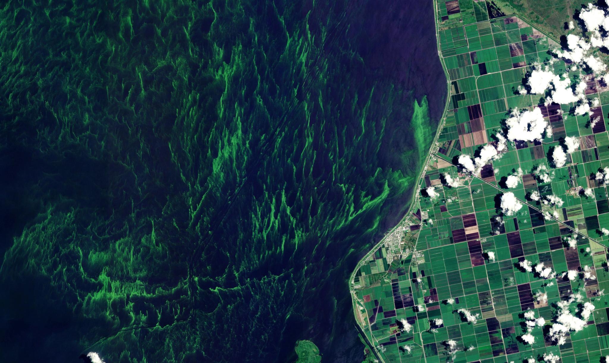
PlanetScope image of an algal bloom in Lake Okeechobee, Florida captured June 12, 2023. © 2023 Planet Labs PBC. All Rights Reserved.
EducationNatural ecosystems like lakes, marshes, and forests are constantly changing and teeming with biodiversity. But not all change is healthy — disease, drought, wildfire, and other perils present serious risks to many natural environments that provide livelihood to local economies and habitats for countless species.
For civil government agencies, monitoring vast and remote territories with traditional ground surveys or periodic aerial flights is slow and expensive. Infrequent observations leave critical temporal blind spots. By the time damage is discovered during a routine check, restoration is often complex and costly.
Near-daily satellite imagery provides a continual and objective way to monitor the health of natural environments across large and often remote regions. By capturing data at regular intervals, satellite imagery helps agencies take a proactive approach and respond to changes as they are happening. Let’s take a look at what that means for managing two key ecosystems: water bodies and forests.
How Satellite Data Supports Water Resource Management
Government agencies are responsible for managing rivers, reservoirs, watersheds, coastlines, and water resources, while improving resilience to flooding, drought, and long-term environmental change. This is further complicated by the need to comply with water quality legislation and an increase in disasters like floods and drought.
Satellite imagery provides insights to respond to these challenges, especially in two key use cases:
- Disaster lifecycle
- Flood extent and inundation mapping
- Water quality and harmful algal bloom (HAB) early warning
- Reservoir level and drought depletion tracking
- Permitting and policy compliance
- Identify encroachment of marine protected areas (MPA)
- Track illegal, unreported, and unregulated (IUU) fishing
- Monitor wastewater and effluent discharge
By tracking water ecosystems from space, teams can make better decisions to prepare for and respond to disasters, as well as identify policy infringement. Learn how Map Impact, a UK geospatial analytics and solutions provider, used Planet satellite data to study and improve water quality of Windermere, England’s largest freshwater lake.
How Satellite Data Supports Forest Monitoring
Government agencies are also responsible for protecting, monitoring, and sustainably managing vast forests, while balancing conservation, economic productivity, resilience, and restoration.
Like water resource management, continual satellite data is used in forestry to minimize and manage disaster risk, and identify illicit activity:
- Disaster lifecycle
- Wildfire risk and fuel load monitoring
- Post-fire burn scar and severity mapping
- Pest and disease mapping
- Permitting and policy compliance
- Track new clearings or roads that indicate unpermitted deforestation
- Identify protected area encroachment
- Validate timber harvesting permits
High-frequency satellite data provides continual insights to help maintain healthy forests and demonstrate sustainable forest management. Learn how the Forest Management Institute (FMI) used Planet data to track and manage the most severe bark beetle outbreak in the country’s history, an infestation that damaged more than 200,000 hectares of forest between 2015 and 2021.
Learn More
You can visit our website to continue reading about how satellite imagery supports natural resource monitoring. Or, if you’re particularly interested in using satellite data to drive policy results, check out our blog article, Strong Environmental Policy Requires Persistent Satellite Monitoring.
Questions You Might Have
Satellite imagery can help detect illicit land use by helping to identify anomalies such as new roads or shifts in land cover that suggest unauthorized logging, mining, or cannabis operations. Because satellites capture images frequently, they can provide evidence of illicit activity as it happens in remote or restricted areas.
Automated systems can alert authorities when a new road appears in a protected forest. This documentation serves as a reliable record to inform action and help prevent further damage to sensitive ecosystems. It also creates a level of transparency that discourages environmental harm.
Key Takeaway: Frequent satellite captures provide the evidence needed to detect and stop illicit activities like unauthorized mining or logging in remote areas.
A wide variety of data can be derived from satellites, including tree height, canopy cover, and forest carbon estimates; as well as land surface temperature and moisture levels in the soil. These measurements are calculated using near infrared and shortwave infrared bands that see beyond the visible spectrum. Analysts use these data points to create vegetation indices that help analysts understand forest health.
Key Takeaway: Spectral sensors provide technical data on plant moisture, land temperature, and forest health that is not visible to the human eye.
Satellite monitoring improves sustainability efforts by providing the transparency and accountability needed to verify environmental claims. Companies use this data to demonstrate that their supply chains are free from deforestation or their carbon sequestration projects are successful. Governments use the observations to track progress toward international climate goals and to manage natural resources for future generations.
Key Takeaway: Satellite data provides the objective evidence required to verify sustainability claims and track progress toward long term environmental goals.
Agriculture is a dynamic business that is vulnerable to threats from weather, disease, and price uncertainty. Increasingly, satellite data is a critical tool for understanding and tracking crop health across the growing season to effectively manage resources and improve harvest yields.
Multi-spectral satellite data allows agronomists to identify specific areas where plants are struggling due to pests, disease, or lack of nutrients. This supports precision farming, where resources like water and fertilizer are applied only where they are needed, rather than across an entire farm uniformly.
Key takeaway: Planet imagery provides the ability to optimize inputs in the field to improve crop yields while conserving resources.

Ready to Get Started
Connect with a member of our Sales team. We'll help you find the right products and pricing for your needs.