
In Conversation: How Governments Can Build Forest Resilience with Near-Daily, High-Resolution
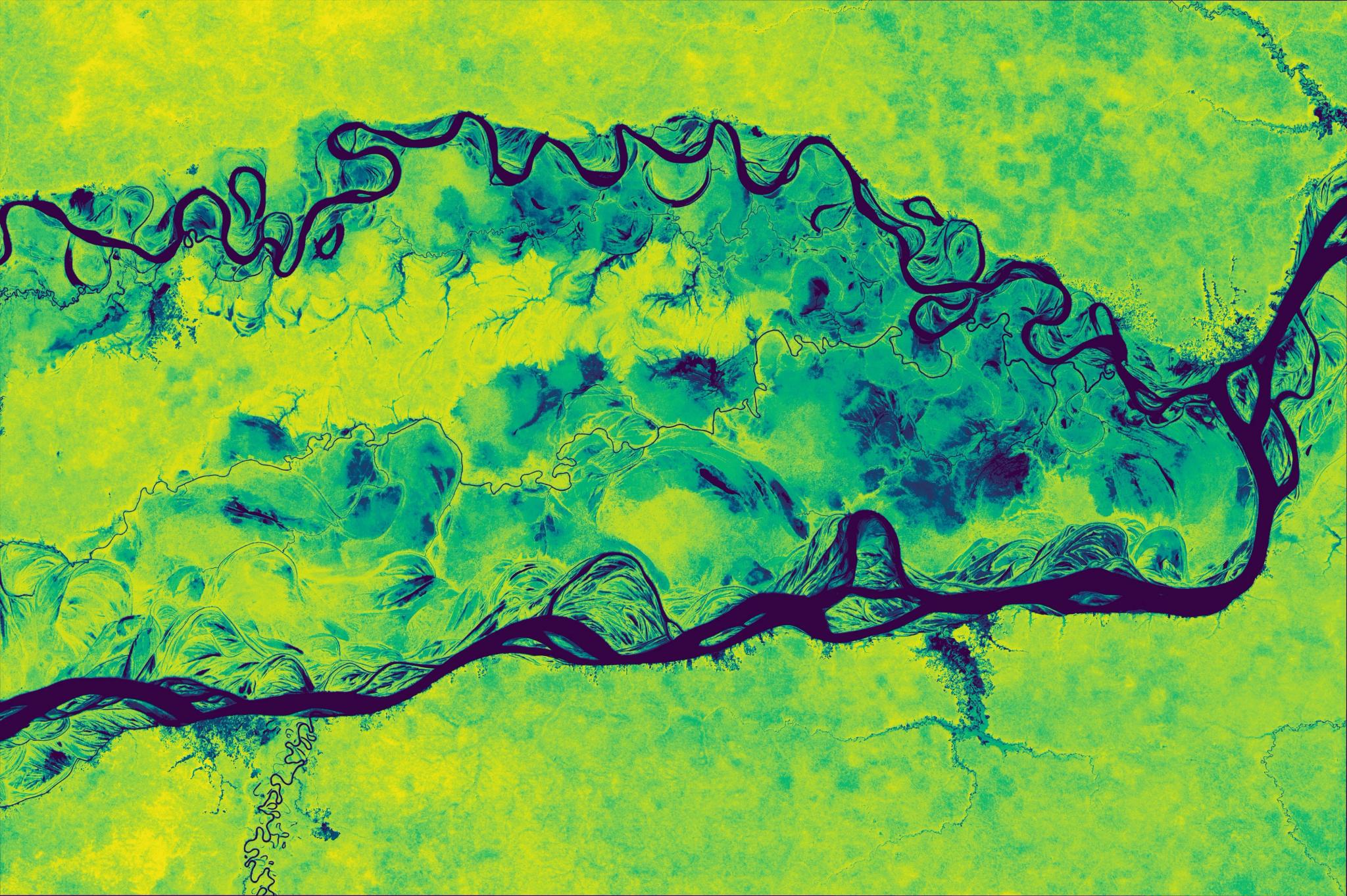
A 5m/px resolution map of Aboveground Carbon Density from Q3 2023, over the state of Amazonas, Brazil. © 2023 Planet Labs PBC. All Rights Reserved.
StoriesAn Interview with Dr. Flávia De Souza Mendes, Senior Program Manager of Forest and Land Use at Planet
Forest agencies are responsible for protecting ecosystems, supporting livelihoods, and enabling economic development, often all at once. Yet they face mounting pressure from climate-driven events, land-use change, and intensifying regulatory demands.
We sat down with Dr. Flávia de Souza Mendes, Senior Program Manager of Forest and Land Use at Planet, to discuss how near-daily, high-resolution satellite data is helping agencies move from long-term monitoring to proactive management and rapid intervention.
In this article we’ll share Flávia’s insights on how agencies can build resilient forest programs. And if you are interested in learning how satellite data and AI are transforming forest management, download our new e-book, Building Forest Resilience with Planet.
A Path Shaped by Environmental Change
Flávia’s journey began with climate rather than forestry itself. She grew up in Brazil, and as a teenager, completed a school project on global warming, which led to a visit to the National Institute for Space Research (INPE). “Walking into that place and seeing the image of the Earth, satellites, everything from space, really opened my mind. It was a wow moment. I realised you could see the Earth from a different perspective.”
That moment shaped her career. “From that day I knew I wanted to work with remote sensing,” she says. “At INPE they mostly work around forests, so over time that curiosity turned into a purpose: understanding how forests change and how we can protect them better.”
When asked what keeps her motivated today, she does not hesitate. “Forests connect almost everything that matters: climate, water, biodiversity, people,” she says. “Every hectare that we are protecting or restoring has a ripple effect.”
Technological progress has reinforced that motivation. “When I started, you would wait weeks to receive a deforestation alert, or sometimes months depending on the cloud cover,” she recalls. “Now, with near-daily data, we can see everything almost in real time. We can act in days. That progress keeps me very inspired and excited.”
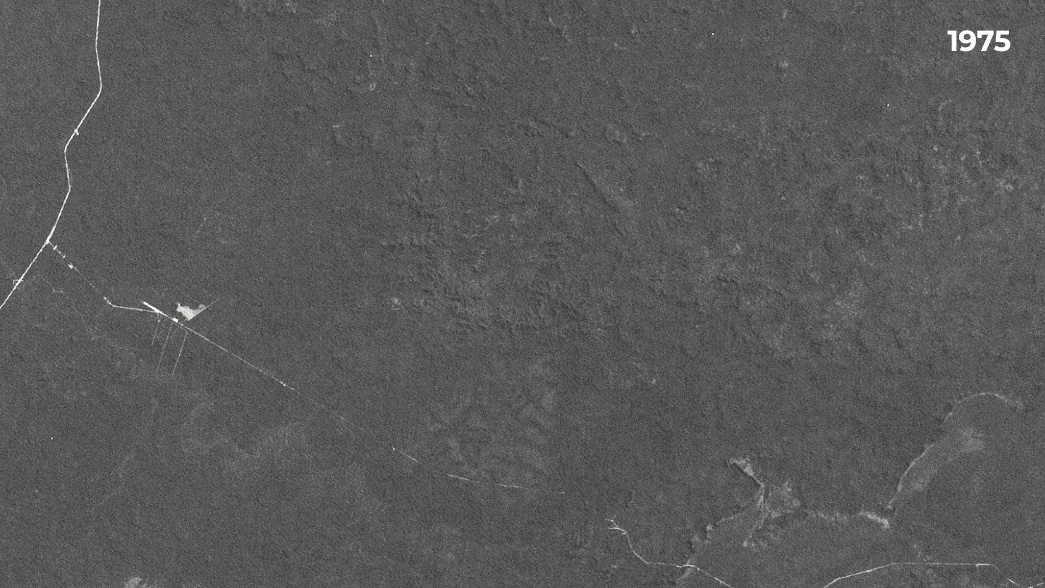
Landsat and PlanetScope imagery showing large-scale deforestation and land-use change in the Amazon between 1975 and 2021.
Forest Change Is Becoming More Complex
When Flávia started her career in 2007, the narrative was focused on large-scale deforestation. “We talked about large clear cuts, big blocks of forest disappearing,” she says. “Today the picture is more complex. The pressure is still there, but it’s now a mosaic of smaller disturbances. Selective logging. Encroachment. New roads. Fires. Diseases that come back year after year.”
These smaller, fast-moving changes can undermine forest health long before an area is classified as lost. “From space, everything may look green, but the forest can be degraded and losing resilience, such as its ability to sequester carbon. So the question is not only how much forest is gone, but what is the quality of what remains.”
When asked what has driven this shift, Flávia points to the role of technology and awareness. “The same way monitoring technology has advanced, the way people extract or clear land has changed too,” she explains. “People know there are satellites. They know when they pass. They understand where clouds can hide activity. So instead of clearing a large area all at once, these activities happen in small patches, quickly, and then move on before the next clear observation.”
This is why frequent, high-resolution monitoring from Planet has become so critical. “If you only have an image every few weeks, you may never see those small disturbances. And they are often the early indicators of much larger change.”
Planet Analytic Feeds reveal the construction of new roads in Bolivia, 2023.
Where Public Satellite Data Fits, and Where It Falls Short
Government agencies around the world rely on free and open satellite datasets. “Landsat and Sentinel are absolutely essential,” Flávia emphasises. “They are the foundation of global monitoring and provide us with a long time-series. Any country, regardless of budget, can build a baseline from them.”
However, limitations appear when agencies need to manage forests day-to-day. Flávia is clear that the answer is not choosing between public and commercial data, but combining them. Public missions provide the strategic, long-term picture. High-temporal, high-resolution imagery provides the operational detail.
“When you need to prevent fires, verify compliance, or act while something is happening, you really need to see the details quickly,” she explains. “That is where near-daily, high-resolution imagery becomes crucial. And by combining this daily visibility with canopy height and cover data from Planet’s Forest Carbon product, agencies can move beyond detecting deforestation to mapping the subtle signs of forest degradation.”
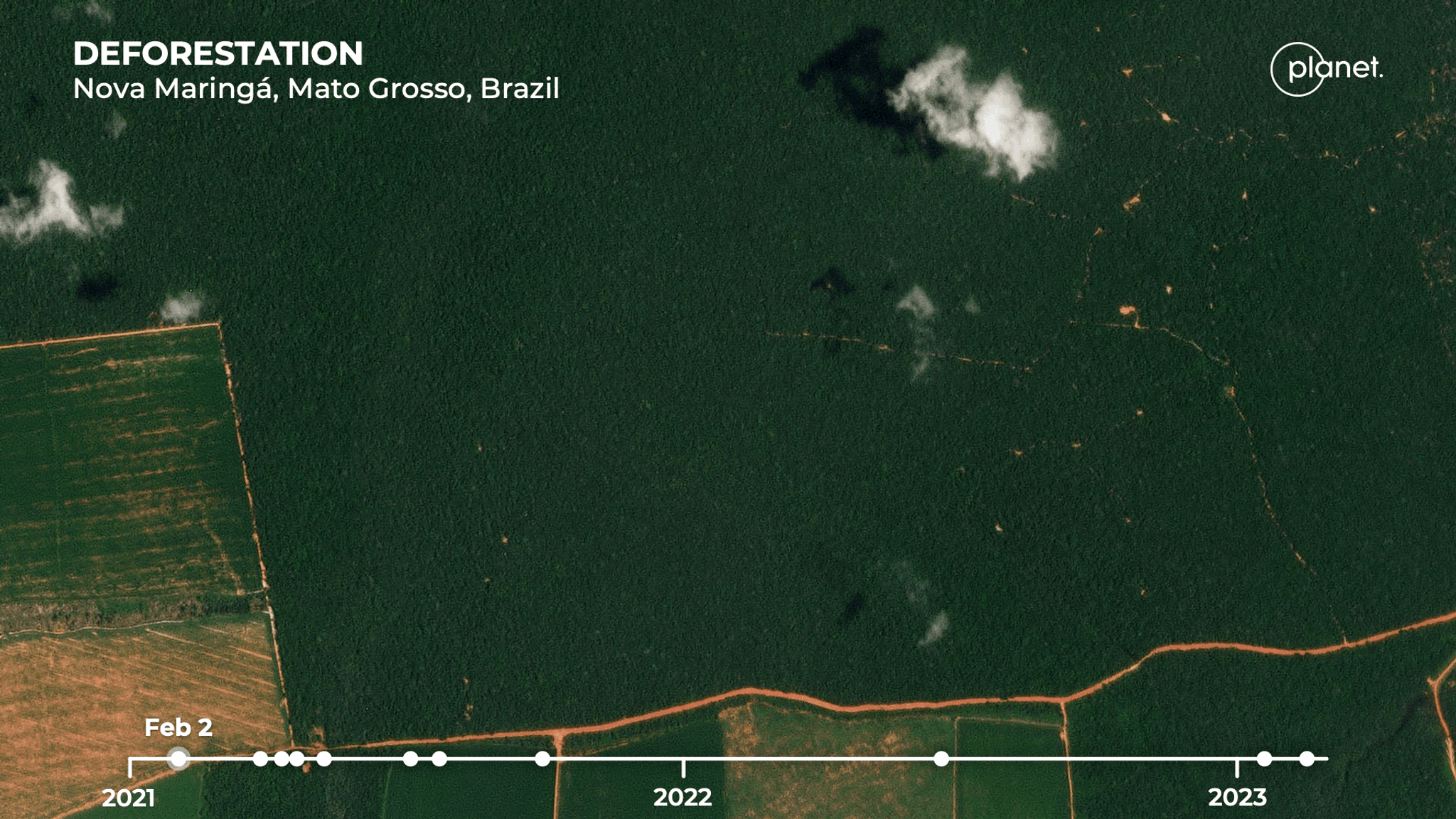
Planet imagery reveals non-compliance with EUDR in Nova Maringá, Mato Grosso, Brazil.
What Planet Near-daily, High-resolution Imagery Changes
“With daily imagery, we move from asking what happened last month to what is happening right now, and what we can do about it,” she says. “Governments can set up early warning systems, plan patrols, verify compliance in near real time, and understand seasonal or emergency conditions without waiting for the next update.”
She gives an example from Brazil. “Federal agencies have used Planet data to detect new roads and selective logging. These are often early signs of something larger. With timely insight, enforcement teams can act while the activity is still happening, not months later. It changes the response time entirely.”
The benefit is not only enforcement. “Daily visibility also supports restoration planning and safer fieldwork. If the forest is flooded, burned, or recovering, you see that before sending anyone into the field.”
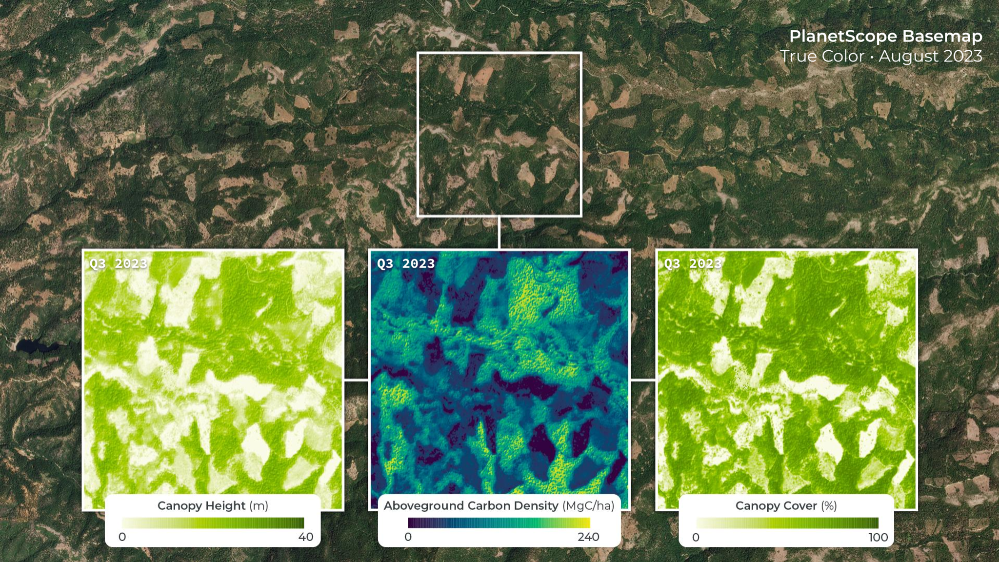
Planet Forest Carbon Monitoring is composed of a bundle of data resources: Canopy Height, Canopy Cover, and Aboveground Live Carbon at 3 meter spatial resolution. The three data layers are shown here over a forested region of California in the United States and help reveal patterns in forests that are not visible in true color imagery alone.
Carbon Markets and Digital Measurement, Reporting and Verification (MRV)
Recent scrutiny on carbon markets has highlighted the need for credible, transparent measurement. “Remote sensing has completely changed what is possible for carbon accounting,” she says. “Satellites extend coverage across entire national territories, including areas that are difficult to access and can measure carbon consistently and independently.”
Planet data helps track tree-scale disturbances and recovery, strengthen baselines, and reduce uncertainty. “That transparency is what climate finance depends on. Reliable, independent data becomes the trust layer for carbon markets.”Having recently returned from COP30 in Belém, Brazil, Flávia is focused on how transparent data can strengthen global cooperation. “Article 6 defines how countries can work together through carbon markets and non-market approaches,” she explains. “The priority now is ensuring that this cooperation is grounded in credible, verifiable data. Remote sensing and digital MRV will be essential to making climate finance transparent and effective.”
Where Governments Should Start
When asked where agencies should begin, she does not start with technology at all. “It’s very easy to say the problem is data or tools,” Flávia notes. “But in reality, coordination is often the biggest barrier.” Many governments already have excellent scientists, but ministries and agencies frequently work in parallel rather than together. “The environmental ministry may use one map, agriculture uses another, and the enforcement team has its own version. Without a shared system, decisions are slower and less consistent.”
The first step, she says, is building one trusted operating picture. To support this, Planet developed Planet Insights Platform — a centralized, cloud-native environment powered by near-daily Earth data and analytics. Governments are using the platform to access Planet’s extensive archive alongside public missions, creating an authoritative foundation for monitoring, analysis, and decision-making across agencies and at national scale.In parallel, she emphasises inclusion. “Local and Indigenous communities should not only provide data. They should be part of decision-making. They are on the front line. They know the forest more deeply than anyone.”
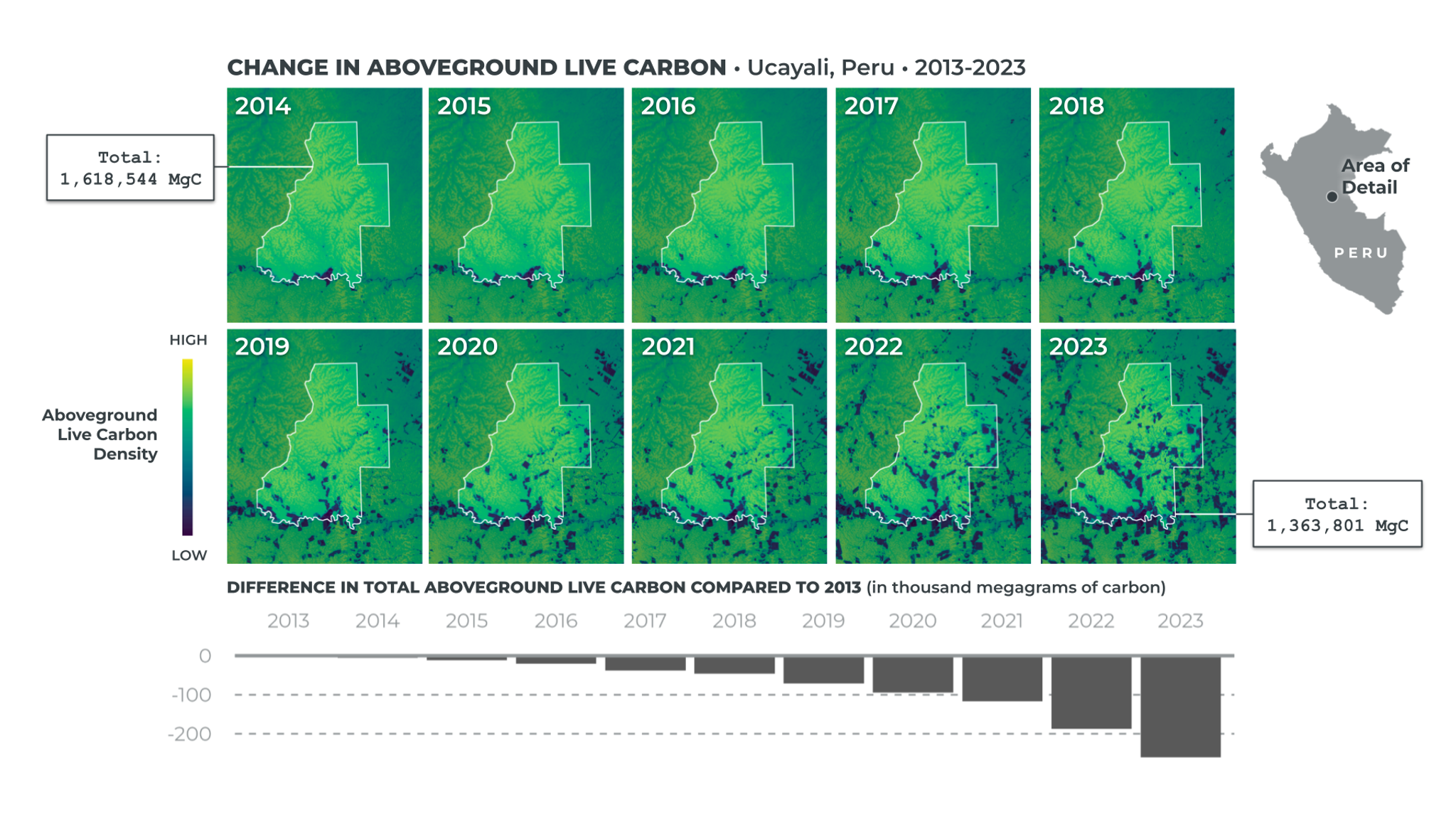
Change in Planet Aboveground Live Carbon data in Ucayali, Peru, from 2013 to 2023.
Looking Ahead
Flávia is energised by what lies ahead. “With Planet’s new Tanager hyperspectral satellite and recently announced Owl constellation, we’ll be able to detect stress, nutrients, and even species differences,” she says. “The challenge won’t be getting the data, it will be simplifying complexity into insight that’s actionable for governments.”
She sees artificial intelligence playing a crucial role in that shift. “AI is helping us interpret this massive amount of imagery faster and in more meaningful ways,” she explains. “It allows us to detect anomalies, predict risks, and summarise patterns across millions of hectares, turning data into decisions.”
For Flávia, that next chapter is about turning information into impact. “We already have the tools to see what’s happening to our forests in near real time,” she says. “The real opportunity now is connecting that knowledge to decisions, helping policymakers, communities, and investors act faster and with more confidence.”
“Forests sit at the centre of climate, biodiversity, and livelihoods,” she says. “By building systems that are connected, inclusive, and credible, we can move from reporting change to truly driving it.”
This interview supports our new e-book, Building Forest Resilience with Planet, which explores how near-daily satellite data and AI-enabled solutions help governments protect, manage, and restore forests with speed and credibility.
Ready to Get Started
Connect with a member of our Sales team. We'll help you find the right products and pricing for your needs.