Inside Slovenia’s Automated Space Resilience Infrastructure: Reshaping Disaster Management Across the Country

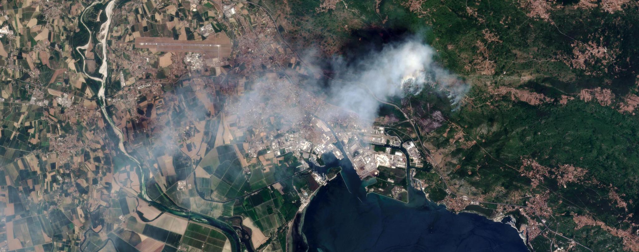
PlanetScope image of the fire along the Slovenian and Italian board, captured July 20, 2022. © Planet Labs 2022. All rights reserved.
NewsThis article was written in collaboration with Daniel Thiex and Davor Deranja.
In July 2022, the Karst region on the Slovenian-Italian border saw the largest wildfire in Slovenian history, burning across around 3,500 hectares over more than two weeks. With more than a thousand firefighters on the ground each day and villages evacuating as the front advanced, the response quickly went beyond national resources, and both the EU Civil Protection Mechanism and the Copernicus Emergency Management Service were activated.
The entire fire was closely watched by hundreds of Earth observation satellites. Planet near-daily PlanetScope™ constellation and Sentinel-2 satellites showed the fire nearly tripled in extent across three days.
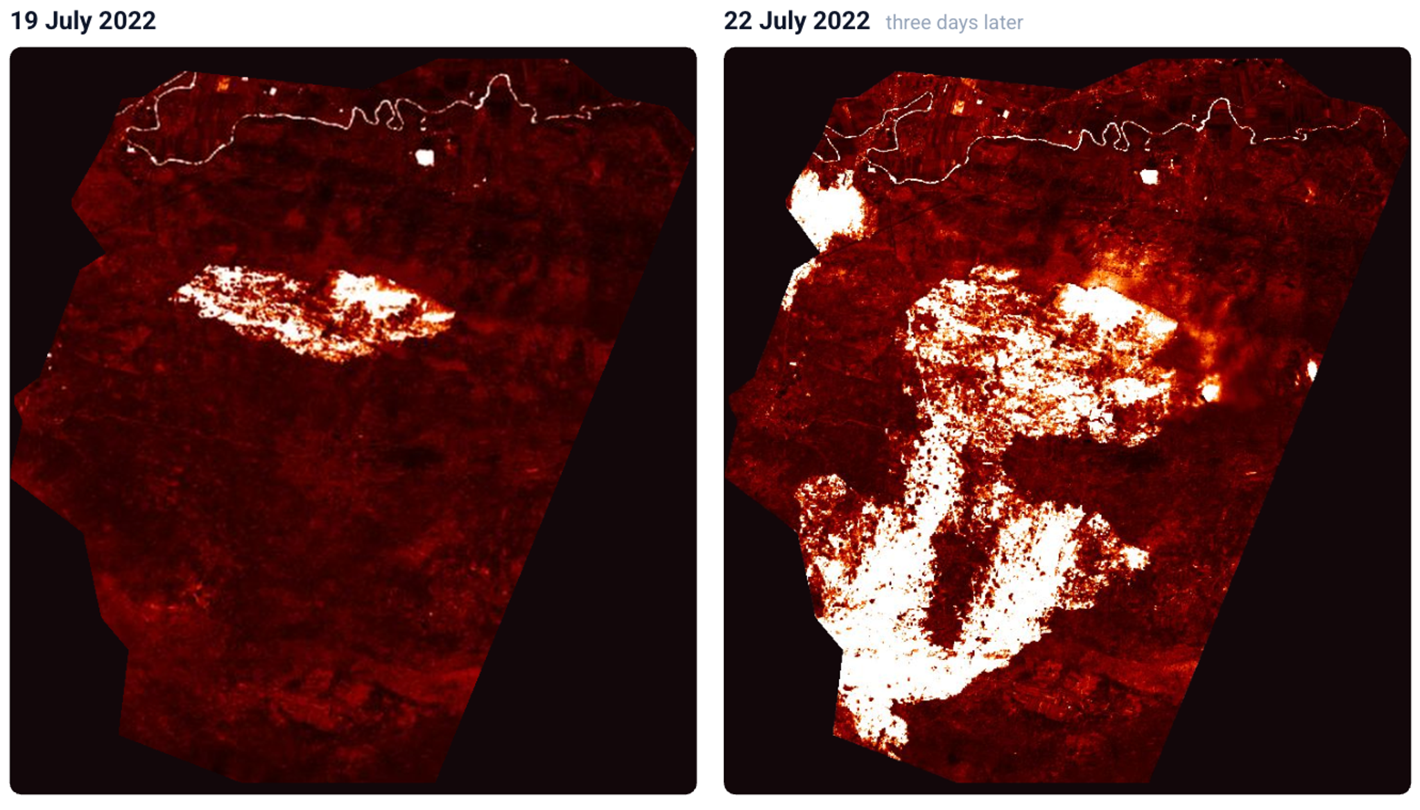
Sentinel-2 L2A, Burn Area Index (credit: the European Space Agency).
During the fire, very high resolution (VHR) commercial imagery was available, showing the active front, passable roads and buildings at risk in detail - so capturing critical data was not the problem. The challenge was getting the data into the hands of the people making life-changing decisions in the field. Traditionally, ordering commercial imagery means navigating provider contracts, approvals and unfamiliar ordering tools, which is slow even for an experienced GIS expert. This means that by the time a request has been placed, approved, acquired, and processed, the fire front has already moved. A timely image can show responders where the fire is spreading, where to send crews and aircraft, and which communities to warn first - but only if it arrives while those decisions are still being made.
A new initiative to enhance Europe’s satellite infrastructure will help minimize this time from image capture to action significantly.
From Detection to Dispatch: Closing the Loop in Disaster Response
The activity has been launched under Element 2 of ESA’s new European Resilience from Space – Earth Observation (ERS-EO) programme. Over the next twelve months, Planet’s Ljubljana-based team, working with Slovenian partner Lucis, will build a resilience platform for Slovenia’s Administration for Civil Protection and Disaster Relief using European infrastructure.
The core idea is a classic tip and cue, closed into a single automated loop.
- Tip: The Space Resilience Node (SRN) will continuously and autonomously analyze satellite time series over user-defined areas, and when a user-set threshold is crossed, automatically dispatch an alert.
- Cue: That same alert will automatically issue a high-priority tasking request across several commercial VHR providers, Planet’s high resolution fleet among them, choosing the imagery that best suits the event, so the order goes out the moment the threshold is crossed, without anyone having to place it by hand. The imagery will come back processed and appear in the responder's map view, ready for analysis and support of the emergency responders in the field.
The true novelty of the Slovenian SRN is that the project will combine monitoring and tasking, which today are usually separate steps with a person in between. The handover between them is where crucial hours in the response chain get lost. Wiring them into one loop will shorten the delay and remove the need for an EO specialist to be on duty and available at the moment a disaster begins.
A Slovenian Pilot, a Blueprint for Europe
Slovenia as a country is ideal to test this type of prototype. With just over 20,000 km2, it is small enough to build the entire chain end to end within a one-year project, and the wildfire risk means that emergency responders have a real demand, and are familiar with the challenges.
Our prototype will focus on demonstrating a tip-and-cue process for wildfires in Slovenia, but the design is not exclusive to wildfires, or Slovenia. The same setup with continuous monitoring, detection, automatic tasking and delivery into an operational tool can be applied to other emergencies such as floods or landslides, or used at other times for disaster risk mitigation and post-event recovery.
In addition, the user interface will be open and its interfaces standards-aligned so that other national nodes can adopt them, rather than rebuild them. Open source also gives a practical route to increased interoperability between national nodes. The Reference Framework that will connect national Space Resilience Nodes to one another is being defined in parallel, under Element 2 of ESA’s European Resilience from Space – Earth Observation (ERS-EO) programme.
If you are building a national Space Resilience Node, working on the Reference Framework, or running civil protection operations, we want to hear from you.
This work is carried out under a program of, and funded by, the European Space Agency. The views expressed here can in no way be taken to reflect the official opinion of the European Space Agency.