
Protecting Our Oceans: How Near-Daily Satellite Data Empowers Governments
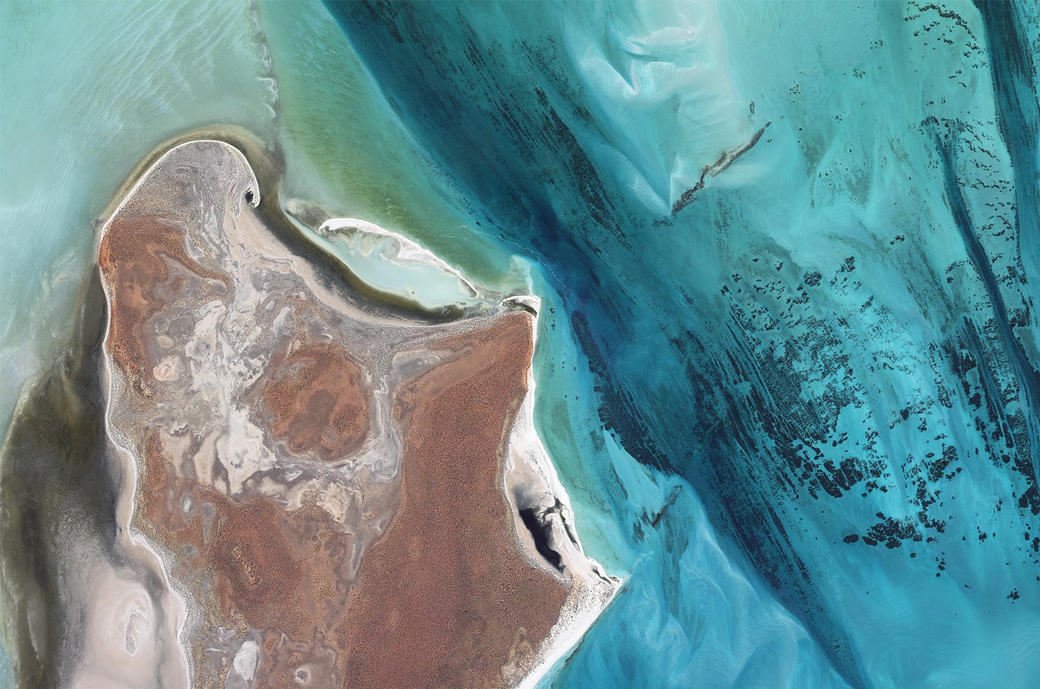
SkySat image of the largest seagrass bed in the world, Shark Bay, Australia, captured April 8, 2023. © 2023 Planet Labs PBC. All Rights Reserved.
TechToday, June 9, 2025, marks the opening of the UN Ocean Conference in Nice, France. As global leaders gather, the world’s attention is rightly fixed on one of our planet’s most vital resources: the ocean.
Yet it’s under severe strain. Increased human activities like intensive fishing, urban expansion, and overtourism have profoundly altered marine ecosystems, particularly in coastal regions. Our oceans are now at a critical juncture for life on Earth. David Attenborough's powerful new documentary, "Ocean," underscores this urgency, revealing both immense challenges and incredible opportunities for its revival.
At Planet, we champion the power of Earth observation data to help us understand life on Earth. Governments worldwide use our high-frequency, high-resolution imagery to monitor coastal zones, which are vibrant hubs of complex ecosystems and marine life. Planet data empowers governments to map and quantify critical blue carbon stores, track harmful algal blooms (HABs), detect illegal fishing activities, and measure water quality across vast marine areas.
Although our ocean faces many challenges, Earth observation data plays a key role in protecting and restoring this critical resource.
Balancing Economic Growth and Environmental Resilience
The ocean is truly the engine of life, fundamental to our very existence and our future. It's a reservoir of rich biodiversity, crucial for regulating our global climate, producing the very air we breathe, sustaining 3.5 billion people as their primary food source, and forming the foundation of many economies through fishing and other vital industries. The ocean's importance to our collective well-being cannot be overstated.
This critical need is now front of mind for governments around the world. The UN has declared 2021-2030 the Ocean Decade, galvanizing global action. Nations are making significant commitments through their own policies or coalitions, like the Global Ocean Alliance. This group of 77 countries aims to safeguard at least 30% of the world’s oceans by 2030 through marine protected areas. Such efforts not only offer tremendous environmental advantages, including enhanced carbon sequestration, but also safeguard the economic value the ocean provides.
To achieve these ambitious goals and effectively protect and restore our oceans, governments need robust tools and abundant data to understand current conditions, monitor changes, and establish well-managed marine protected areas. Earth observation data offers the scalable, comprehensive insights needed to empower governments with near real-time understanding and historical context, particularly in coastal zones, which are home to mangroves, seagrass, and coral. These aren't just the foundations of marine ecosystems; they are significant "blue carbon" sinks, often able to sequester more carbon than the same area of tropical rainforest, while also serving as vital nurseries and protective barriers for coastlines.
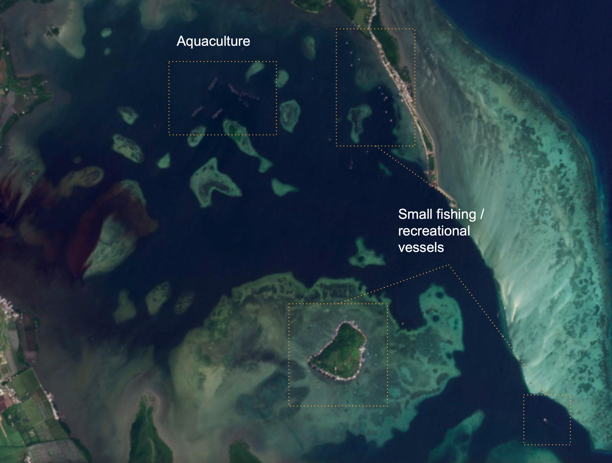
PlanetScope image showing likely aquaculture and small fishing or recreational vessels, North Bais Bay, Philippines, captured January 25, 2025. © 2025 Planet Labs PBC. All Rights Reserved. Image and annotations produced by Global Fishing Watch.
Insights From Space: Powering Coastal Protection
Broad area management is the practice of leveraging Earth observation data to monitor, measure, and report changes across large geographic areas. Planet’s approach to broad area management combines daily monitoring, high-resolution imagery, analysis-ready data, and analytics to help governments identify and monitor change, validate hazards, and take informed action.
PlanetScope Monitoring™ provides a near-daily scan of the Earth, including a comprehensive view of coastal zones spanning vast areas and regions. Together with our partners and customers who specialize in satellite-derived marine insights, Planet empowers governments to protect and restore these critical coastal zones. Through this approach, agencies can:
- Go Broader: Monitor coastal zones spanning extensive regions, including areas inaccessible to humans.
- Look Backwards: Quantify change over time, including coastal erosion and vegetation loss, against baselines using Planet's historical data archives.
- Get Closer: Detect illegal activities, such as fishing in no-take zones, and create systems to alert authorities in near real-time.
- Delve Deeper: Analyze multiple factors influencing coastal zones, such as water turbidity or water pollution, impacting overall ecosystems.
This comprehensive approach helps governments not just monitor, but work towards creating a digital twin of their coastal zones, offering a dynamic, constantly updated virtual representation for proactive management.
Real-World Impact: Governments Leverage EO Data for Marine Resilience
This powerful combination of near-daily Earth data and advanced analytics is already delivering tangible results for governments and organizations worldwide.
Accurately identifying and mapping vast blue carbon ecosystems like seagrass has traditionally been labor-intensive and costly, making it difficult to scale. However, UMITRON, for instance, used PlanetScope® data to revolutionize this process in Japan. Facing the challenge of observing over 100 km² of targeted area, they found that Planet high-frequency imagery allowed them to create detailed seagrass maps, successfully estimating blue carbon content. This approach has even led to the discovery of previously undiscovered seagrass, accelerating efforts to increase blue carbon. This efficient method, successfully demonstrated in Japan, paves the way for other countries to manage national carbon accounting and planning.
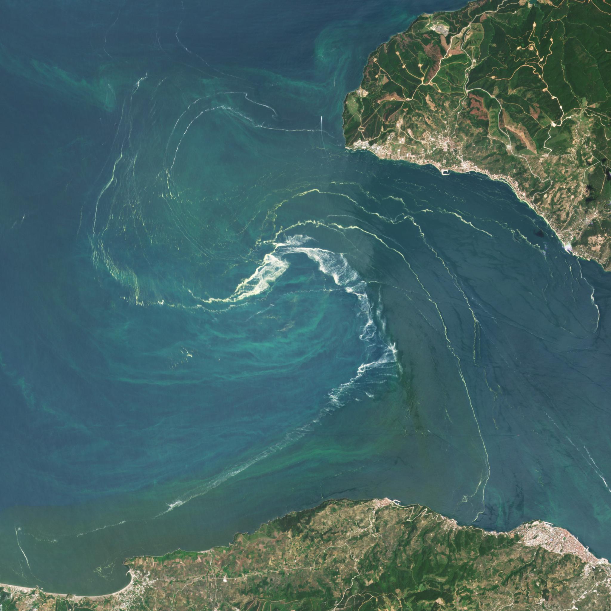
PlanetScope image of phytoplankton, often referred to as sea snot or sea saliva, swirl in the Sea of Marmara, captured June 10, 2021. © 2021 Planet Labs PBC. All Rights Reserved.
Another critical challenge is the monitoring of red tides, harmful algal blooms (HABs) which can pose significant threats to human health, ecosystems, and industry. EOMAP leverages Planet data to deliver near-real-time monitoring of these dynamic events. This addresses the limitations of traditional methods, which often lack sufficient coverage or spatial resolution. In addition to controlling/overseeing large coastal areas, the data enable early warnings and thus help mitigate or even avoid environmental risks.
Historically, understanding the full scope of human activity across our vast oceans has been a significant challenge. Unlike the detailed mapping available for terrestrial features like buildings and roads, the extent of marine human activity — including fishing, recreation, offshore energy installations, and even some shipping — remains largely uncharted.
Global Fishing Watch, leveraging Planet advanced imagery and industry advancements in AI, is transforming this understanding. By processing over 2 million square kilometers of ocean area daily, they can detect and map the activity of hundreds of thousands of fishing vessels in coastal waters globally. This unprecedented capability more than triples the number of vessels detectable through existing public methods, making it possible to map the majority of the world's fishing effort. These more detailed maps of human activity are crucial for policymakers, aiding in the identification of optimal marine protected area locations and enabling better estimation of carbon emissions from all vessels at sea.
Planet Is Ready: Charting a Thriving Ocean Future
As governments convene in France and look to strengthen commitments for protecting more of our oceans, Planet and our partners are ready to support their ambitious goals.
Marine environments have an extraordinary capacity to recover under the right conditions. This resilience will not only help us reduce the severity of human-caused change, but also improve food security and protect our economies. Planet is committed to empowering governments to seize this opportunity. By providing the essential data and tools, we are ready to help researchers and policymakers write the next chapter for our oceans.
Ready to take action? Discover how Planet's solutions can support your mission. Explore detailed insights in our Multidimensional Coastal Monitoring e-book, developed in partnership with EOMAP, or contact us today.
Ready to Get Started
Connect with a member of our Sales team. We'll help you find the right products and pricing for your needs.