Planet and SatAgro Maximize Farm Margins With Near-Daily Insights

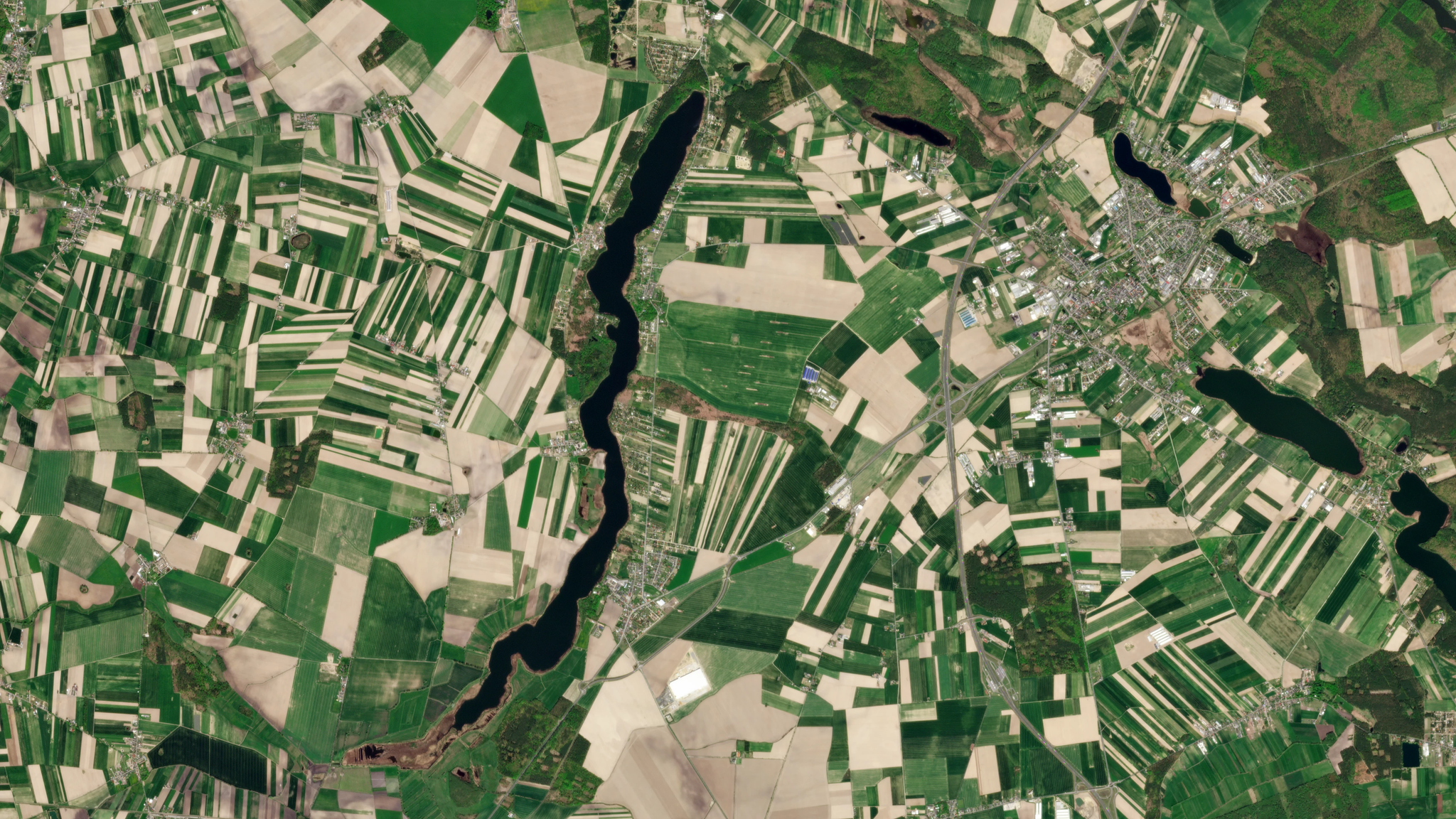
PlanetScope image of fields in the region near Poznan, Poland, captured April 28, 2026. © 2026, Planet Labs PBC. All Rights Reserved.
StoriesThis article was written in collaboration with Przemysław Żelazowski, Founder of SatAgro.
For decades, success in agriculture has been measured by a single metric: average yield. While yield is vital for food security, this mindset can mask significant financial risks. The reality is simple — peak yield does not always equate to peak profit. By focusing solely on volume, growers often overlook hidden costs in over application and missed opportunities within field variability.
Today, the most successful growers are shifting their focus to overall profitability. By identifying natural field variability — including differences in soil, drainage, and microclimate — farmers can manage their inputs with precision rather than applying uniform treatments. This shift turns suboptimal resources into optimized margins.
Planet is proud to partner with SatAgro, who helps farmers adopt digital agriculture to improve their environmental footprint and bottom line. By combining near-daily PlanetScope® satellite imagery with farm management tools, the SatAgro platform enables growers to analyze performance at a sub-field level. Together, we are democratizing precision agriculture, making data-driven farming a practical, sustainable reality for growers of all sizes.
A Decade-Old Revolution
In 2015, precision agriculture based on good quality crop monitoring was an expensive luxury. "Only the biggest farms could afford it, plus we were treading quite new waters," says Dr. Przemysław Żelazowski, SatAgro’s founder.
That landscape shifted in 2016 with the availability of Copernicus Sentinel-2 and PlanetScope data. While this democratized access to basic field insights facilitated by public data, a critical "resolution gap" remained. Standard, lower-resolution monitoring often doesn’t catch variability in smaller or irregularly shaped fields, effectively blocking them from the benefits of precision farming. Without higher-resolution data, these fields remain a "black box" of missed efficiency.
As the Polish Agency for Restructuring and Modernisation of Agriculture publishes new crop maps, the scale of this opportunity is now quantifiable. SatAgro identifies the threshold of Sentinel-2 usefulness at around 2 hectares (~5 acres). As shown in the figure below, PlanetScope captures 10 times more detail per acre, lowering the barrier to entry for fields as small as 0.2 hectares. This technology unlocks 37% of Poland’s arable land previously unreachable by standard monitoring, driving efficiency gain.
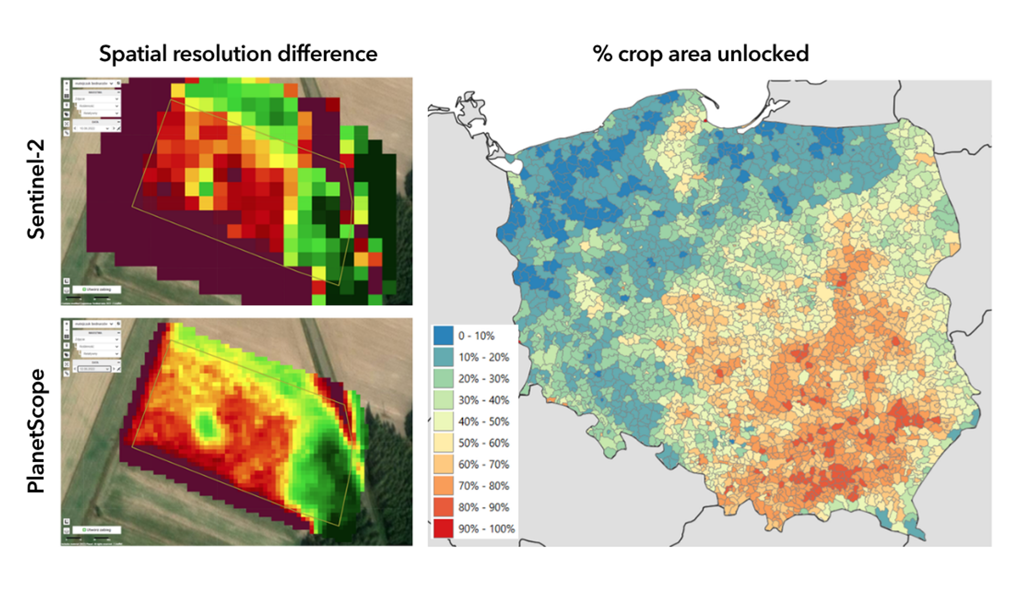
Percent of additional crop area unlocked for satellite-informed precision treatments due to availability of 3 m PlanetScope data, compared to the 10 m Sentinel-2 data baseline.
Beyond resolution, the added benefit of near-daily imaging frequency is indispensable especially in consistently cloudy regions, such as the Polish coast, where it ensures farmers maintain a reliable, actionable stream of data regardless of the weather.
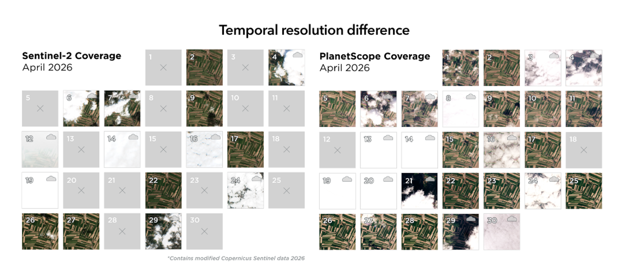
A comparison of coverage in April 2026 for Sentinel-2 and PlanetScope over a set of fields near Poznan in Poland.
Satellite Intelligence Throughout the Crop Cycle
The partnership between Planet and SatAgro provides a strategic advantage throughout the agronomic calendar. From low-margin wheat to high-value sugar beets and potatoes, satellite intelligence empowers growers at every stage, as indicated in the graphic below
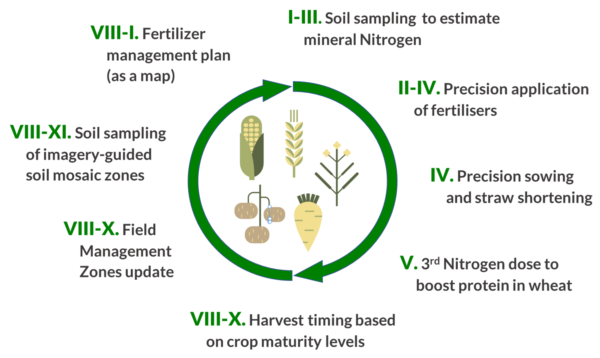
Satellite monitoring-influenced interventions across a 12-month crop production cycle.
"All benefits from satellite images can be split into two main categories: optimisation through long-term productivity patterns or short-term crop condition details," says Konrad Sikora, SatAgro's chief agronomist.
Long-term management focuses on farm management zones derived from historical imagery to highlight permanent soil variability, such as water retention and nutrient capacity. These zones are essential for early-season tasks like soil sampling, precision sowing, and initial fertilizer planning.
Conversely, real-time crop monitoring directly impacts quality and profitability. For example, visualizing crop condition gradients from optimal to under-developed or damaged allows growers to adjust Nitrogen application precisely, reducing usage by up to 30% in some scenarios. By allowing farmers to make these precise adjustments rather than applying broad, blanket treatments, this strategy directly converts data into predictable, repeatable margin gains.
Not One Size Fits All
Regional technology and culture shape how farmers work, but farm size often determines the specific tools they choose. From small family farms to large-scale industrial operations, SatAgro helps growers leverage Planet satellite data to reduce risk, drive efficiency, and boost profitability.
Small farms (10 to 100 hectares)
With Planet, SatAgro provides an accessible entry price point for precision farming, as low as €100 per year, that makes sense for small family operations. These farms, which account for roughly three-quarters of Polish agriculture and represent one quarter of arable land, are uniquely positioned to benefit from this technology. They are agile, deeply familiar with their land, and now empowered by the same near-daily intelligence as large-scale industrial growers.
This data-driven approach allows small farmers to optimize every hectare, and opens a new revenue stream: EU compliance. Satellite insights simplify the complex documentation required for Common Agricultural Policy (CAP) ecoschemes. Climate action, which hinges on reducing greenhouse gas emissions and enhancing carbon sequestration, is one of the CAP's ten core objectives. SatAgro’s spatially-explicit fertilizer management plans streamline carbon farming qualification, resulting in notable cost savings. For example, one of their growers, Mr. Piotr Atlas, has used Planet data and the SatAgro platform to achieve a 9% reduction in fertilizer costs and a subsidy boost of 20 Euro per hectare.
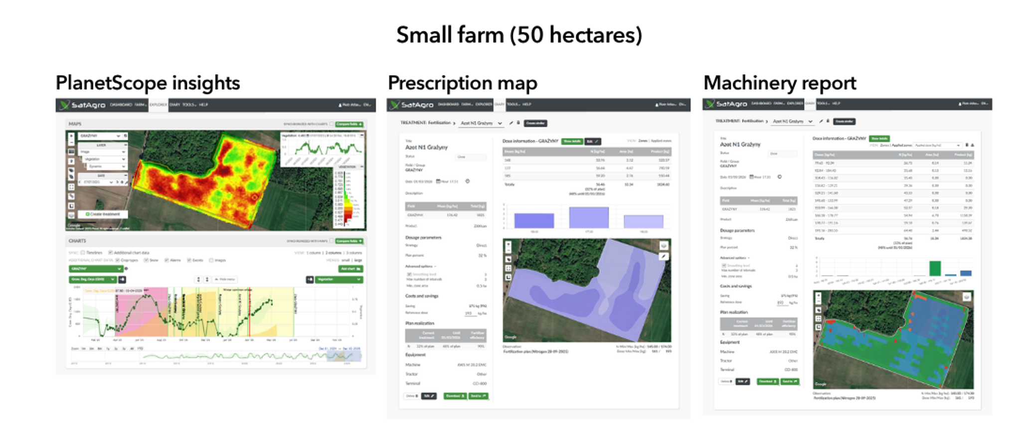
Precision farming interventions for small farms involving PlanetScope data, verified by machinery data, showing spatially explicit fertilizer management plan (9% fertilizer saving, plus extra subsidy).
Medium Family-Owned Farms (100 to 1,000 Hectares)
Medium-sized operations are often the backbone of agricultural production; while they represent less than a quarter of all farms, they manage roughly half of all arable land. These growers are typically tech-forward, utilizing comprehensive digital toolkits to implement full-scale precision agriculture. Because they manage significant acreage and face complex reporting requirements, they rely heavily on streamlined, integrated workflows to remain efficient.
To save time and improve accuracy, these growers utilize SatAgro’s integrations with platforms like John Deere Operations Center, FarmEngage, and agrirouter. This seamless connectivity enables a critical two-way data flow: satellite insights move directly to machinery for variable-rate applications, while performance data is automatically retrieved to simplify reporting.
For example, grower Marcin Wojciechowski uses PlanetScope imagery to design soil sampling zones that reflect the unique soil mosaic of his fields. Integrating laboratory data back into the SatAgro platform provided him with a basis for precision treatment prescriptions. As shown in the figure below, this approach optimized his liming — a high-input task — by aligning application rates with soil acidity levels. This precision not only improved crop health but also significantly reduced logistical costs and fuel expenditure, with all application data automatically imported back into the SatAgro platform for final assessment.
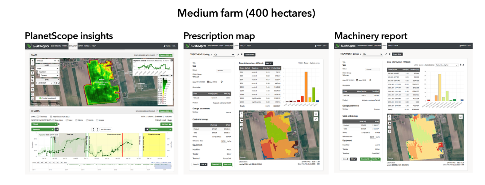
Precision farming interventions for medium farms involving PlanetScope data, verified by machinery data, showing liming aligned with pH measurements within field management zones.
Large, Industrial Agricultural Operations (Over 1,000 Hectares)
At the industrial scale, the challenge shifts from individual field management to orchestrating operations across thousands of hectares. SatAgro provides managers with a consistent, regional view of crop conditions, enabling efficient resource allocation across vast portfolios.
In these environments, telematics is the critical connector. While Planet imagery provides the strategic view and identifies where precision is needed, telematics delivers the tactical execution. By streaming tasks directly to machinery and verifying application rates, this combination ensures that precision plans are not just created, but accurately executed on the ground. It simplifies reporting and provides operational transparency.
The impact is amplified by the sheer scale of the operation. At the 5,000-hectare Polhoz farm, for example, a modest 1% reduction in the final nitrogen application across 1,400 hectares of wheat targeted specifically to areas affected by frost and drought, results in a 2-ton reduction in fertilizer. This same high-resolution precision can yield even steeper results; as shown in the figure below, we have seen reductions as high as 15% on individual tracts.
Beyond input optimization, regional management opens doors to advanced logistics, such as automated harvest planning and predictive yield modeling. This expertise is already delivering results at scale, as seen in our shared work with the American Crystal Sugar Company, where SatAgro supports optimized monitoring across 160,000 hectares of sugar beets.
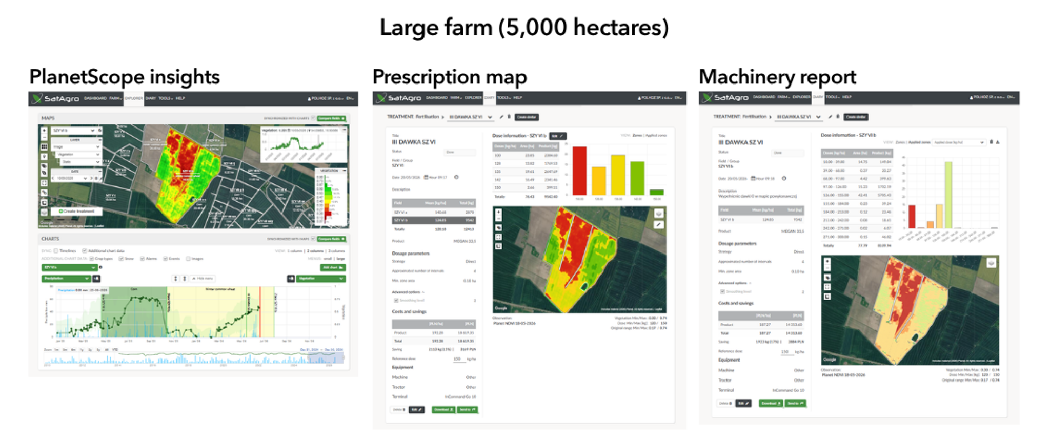
Precision farming interventions for large farms involving PlanetScope data, verified by machinery data, showing reduction of the last nitrogen application on wheat damaged by frost and drought (15 % saving).
The Second Decade: What to Expect?
The next decade promises even more innovation, anchored by the operational availability of hyperspectral imagery pioneered by the Planet Tanager™ mission. "Hyperspectral-based stress and disease detection, paired with autonomous drones, will be a game-changer for crop protection," says Krzysztof Stopa, SatAgro’s CTO.
Building on a decade of success in Poland, SatAgro is expanding its global infrastructure and AI capabilities. By focusing on deeper process automation and farm autonomy, the company is seeking to scale their vision for a future defined by sustainable, data-driven farming and optimized profitability.
Read our e-book to learn more about using Planet data to drive crop management, or create a free SatAgro account to start maximizing your farm’s potential.