
Protecting Endangered Biodiversity with Project Centinela
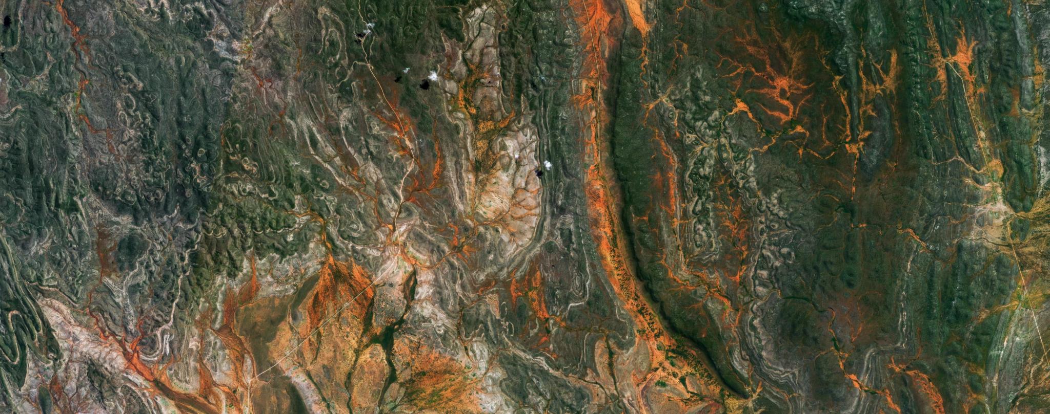
PlanetScope image of the Orupupa Conservancy in the Kunene Highlands of Namibia, a Project Centinela site, captured May 27, 2025. © 2025, Planet Labs PBC. All Rights Reserved
StoriesBy Seamus Lombardo and Amy Rosenthal
From space, Planet satellites observe Earth’s surface as it changes, on a daily cadence. They see forests burn and coral reefs bleach, as well as prairie grasslands restored to resplendent color and mangroves sprouting from coastlines. Ongoing monitoring provides an opportunity to intervene where nature is at risk, and to celebrate conservation results that benefit people and wildlife.
As a public benefit corporation (PBC), Planet is committed to using space to help life on Earth. We are leveraging our constellations and a growing set of AI-powered analytics to help protect biodiversity and restore nature around the globe through Project Centinela. Developed by Planet to help leading scientists, conservationists, and stewards monitor and safeguard 50 of the world’s most vulnerable biodiversity hotspots, Project Centinela delivers high-resolution, high-frequency satellite imagery, Planetary Variables®, and new tailored tools to teams maintaining a lifeline for biodiversity in at-risk sites and supporting the communities who depend on them. A year after the program was launched, let’s take stock of the impact it’s had around the world.
A Growing Impact After One Year
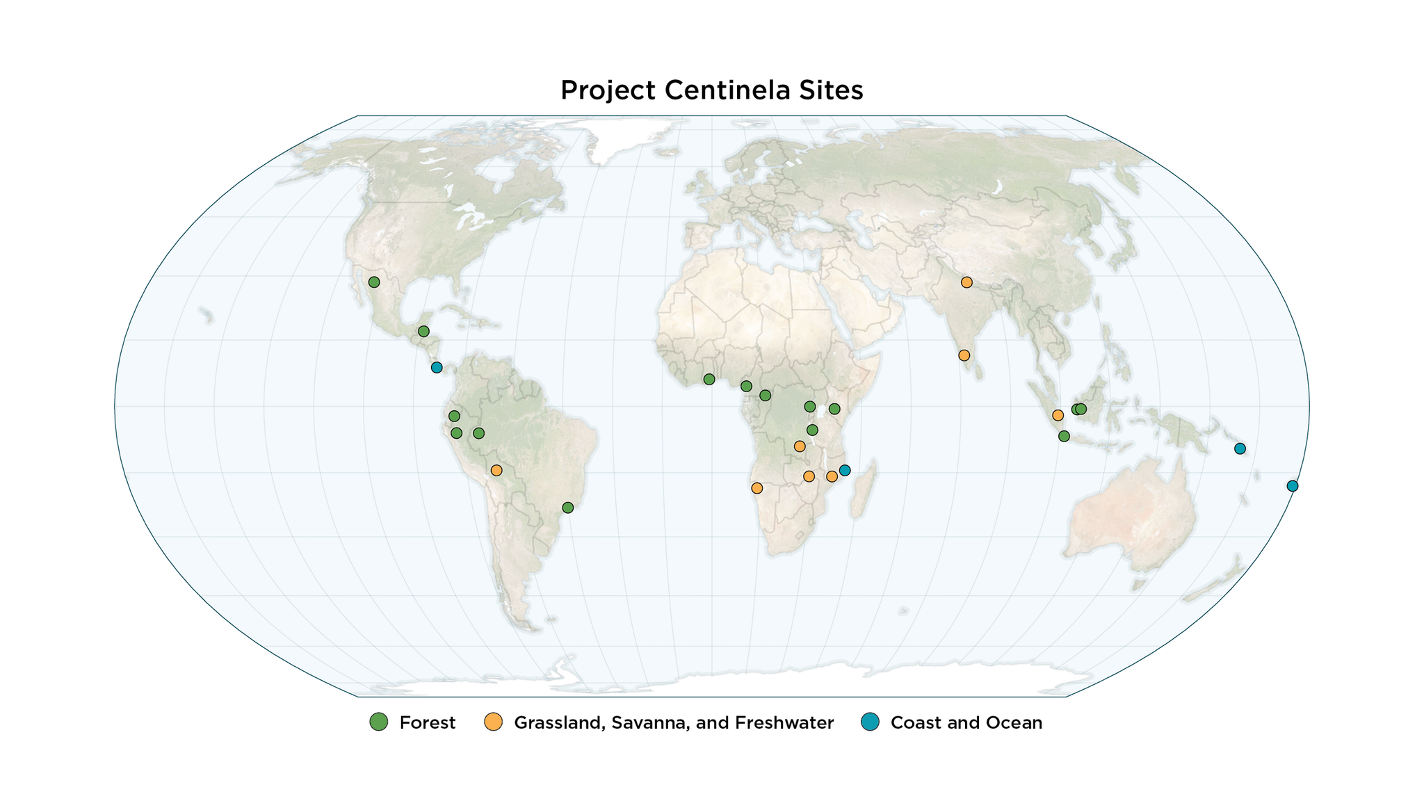
We inaugurated the program with an initial set of 10 sites in late 2024. At the beginning of 2026, we’re proud to announce that more than 25 sites have come into the program, receiving three-year “biodiversity subscriptions” for free from Planet. These sites span dozens of countries and biomes, ranging from Amazonia rainforests to African savannas to coastal areas in the Pacific Islands.
.
As part of our ongoing impact assessment for Project Centinela, we have collected data for 18 sites. In these sites, Planet imagery and analytics are being used by conservationists to protect and restore:
- 271 protected and conserved areas
- 132 Key Biodiversity Areas
- 845 threatened and endangered species
These species include rare orchids and jaguars in the Amazon, lowland gorillas and mountain bongos in Africa, and monkey-faced bats and threatened corals in the Pacific. Project Centinela sites intersect hundreds of areas of high-conservation value. Sites encompass world-renowned national parks, such as Upemba in the Democratic Republic of the Congo and Etosha in Namibia, as well as global biodiversity hotspots like India’s Western Ghats, which features dozens of Key Biodiversity Areas.
To continue to scale this impact, we will accept new sites into the program every quarter of 2026.
Centinela Sites Around the World
Project Centinela sites gain access to a deep stack of Planet imagery and analytics that they can use to address an array of conservation and restoration challenges. So far examples of these use cases include reporting environmental crimes, developing community management plans, monitoring forests to combat deforestation, generating biodiversity credits, and evaluating regenerative agriculture. Several of these stories follow, reported by the Project Centinela site teams themselves.
Eastern Chimpanzee Conservation Areas, Uganda and Tanzania
In partnership with Jane Goodall Institute (JGI)
The Jane Goodall Institute has deep roots in Uganda and Tanzania, where JGI has long supported effective conservation for chimpanzees, community-led development, and advanced environmental education for youth. Through Project Centinela, JGI is supporting implementation of national and site-specific conservation action plans, village and district land use plans, and facilitating local communities and governments to protect their Village Land and Local Authority Forest Reserves (VLFRs and LAFRs), national parks, and other protected areas.
Over the first year of collaboration, JGI has begun to assess chimpanzee habitat health and threats, including mapping areas affected by wildfires and monitoring illegal deforestation with Planet data.
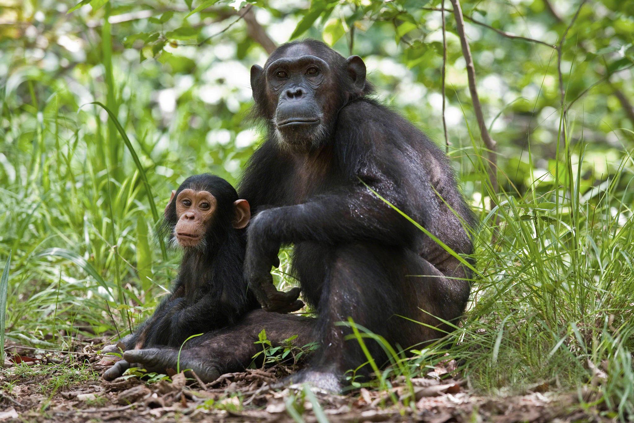
Chimpanzee mother and child sit in healthy woodland habitat. Credit: Jane Goodall Institute
“The temporal resolution of the imagery has been exceptional. Daily updates make it possible to track rapidly evolving phenomena such as deforestation and specific threats like logging with remarkable precision, providing actionable insights and guiding local conservation decisions,” noted Dr. Lilian Pintea, Vice President of Conservation Science at JGI.
Using PlanetScope® imagery, JGI tracked and characterized illegal deforestation in the Bugoma Central Forest Reserve in Uganda, which serves as critical chimpanzee habitat in the country’s National Chimpanzee Conservation Strategy. With near-daily data, the team identified 1,343 hectares of encroachment and degradation and submitted it as concrete, spatially explicit examples of ongoing illegal deforestation to policymakers and conservation managers. These alerts have prompted renewed attention and commitment to strengthening enforcement to protect, and potentially restore, what remains of this critical ecosystem.
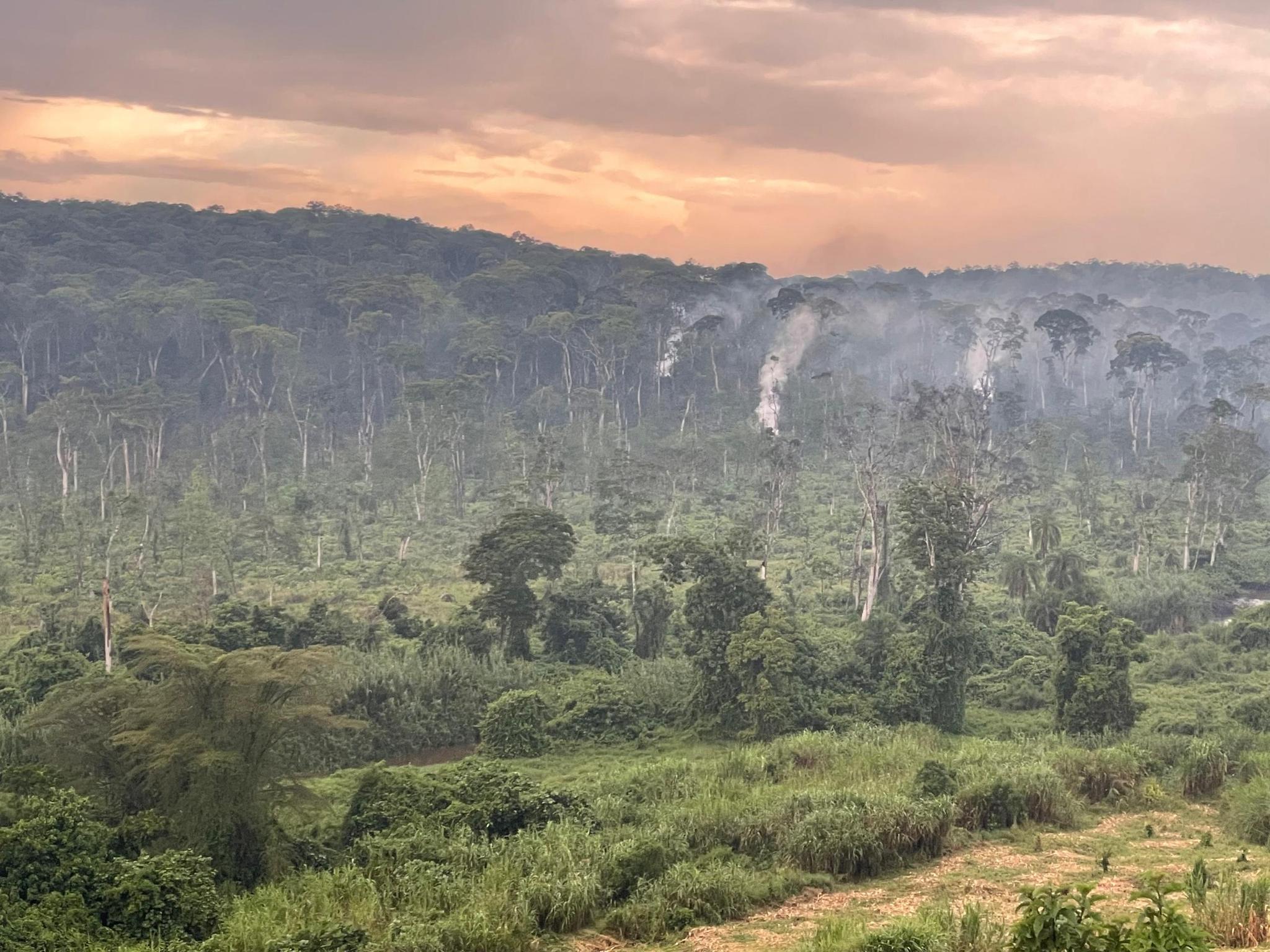
Illegal deforestation in Bugoma Central Forest Reserve in Uganda. Credit: Jane Goodall Institute.
Sacred Headwaters, Ecuador
In partnership with Fundación Pachamama, Amazon Sacred Headwaters Alliance, and Regen Network
The Amazon Sacred Headwaters bioregion spans approximately 86.5 million acres across the Ecuadorian Amazon and northern Peru, which is home to more than 30 Indigenous nations. Despite its exceptional biodiversity and cultural richness, the region faces major challenges, including systemic poverty, biodiversity loss, and ecosystem degradation.
In partnership with the Achuar Nation of Ecuador, Fundación Pachamama, Amazon Sacred Headwaters Alliance, and Regen Network have co-developed a pilot biocultural conservation model grounded in territorial sovereignty and Indigenous stewardship, which they plan to expand across the bioregion. At this Centinela site, Planet imagery and analytics are used to monitor deforestation, strengthen Indigenous guardianship, and advance biocultural jaguar stewardship units as an innovative conservation finance mechanism. The effort combines remote sensing and on-the-ground, community-led data collection and validation methods to produce biodiversity credits and secure effective conservation and autonomy for the peoples who have long called the region home.
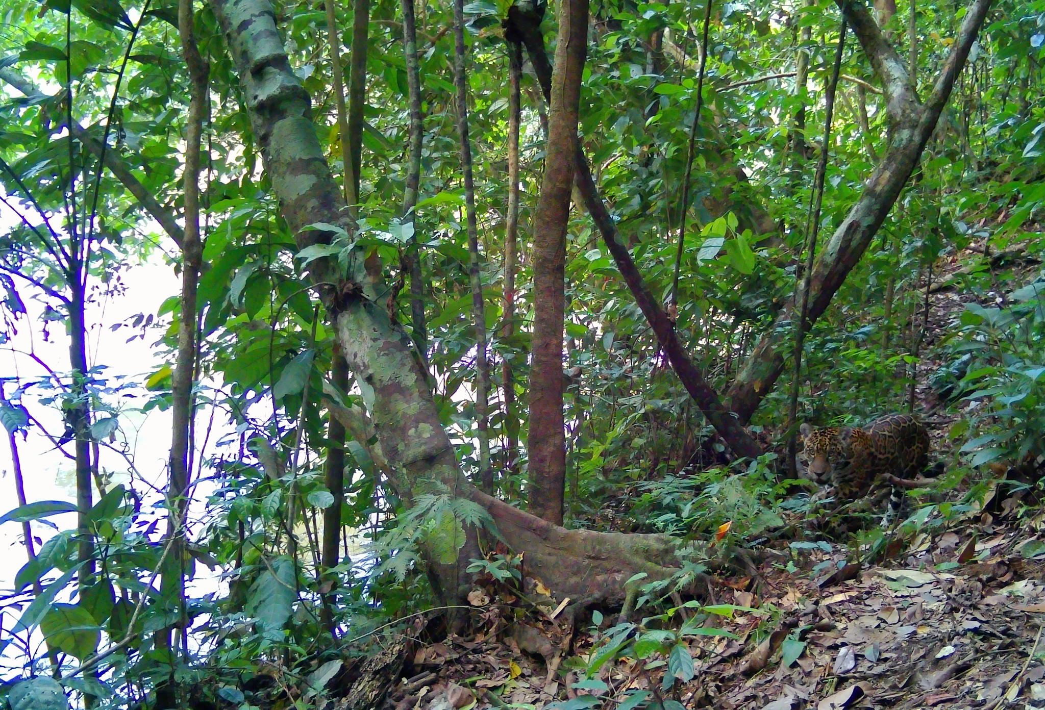
A jaguar stalks in the rainforest near Wayusentsa. Credit: Image captured through community-led monitoring in Achuar territory – Wayusentsa Community, in collaboration with Fundación Pachamama and Project Centinela partners.
Using SkySat® tasked imagery, the team has been monitoring areas of high ecological and social relevance in their biocultural jaguar stewardship strategy and along a new road being cut through the forest into Achuar territory. This high-resolution imagery informs a socio-environmental impact assessment and has helped refine operational timelines, plans for credit allocation, and product performance. PlanetScope imagery and Planetary Variables have enabled timely and data-driven responses to emerging territorial threats, such as illegal mining and road expansion within Indigenous territories, and serve as up-to-date, high-resolution evidence to support strategic discussions with partners and stakeholders.
Loading Video...
PlanetScope timelapse showing illegal mining and deforestation in Morona Santiago, Ecuador. Credit: Joel Koupermann, Fundación Pachamama
The team leads have drawn on these data and the program to develop capacity for remote sensing and spatial analytics literacy across the site team, establishing the foundation to integrate these tools into territorial planning, ecological restoration, and community agroforestry, as well as the design of carbon projects developed by the Amazon Sacred Headwaters Alliance.
Sky Aelans, Solomon Islands
In partnership with Conservation Metrics, Islands Knowledge Institute, Mai-Maasina Green Belt, Imazon, and Nia Tero
On the islands of Malaita, Central, and Guadacanal, Indigenous Solomon Islanders have stewarded their lands and waters for thousands of years, holding their “Sky Aelans” sacred. Today, they are threatened by outsiders, who illegally cut and sell old-growth trees, cut away the protective mangroves, pump out gold from rivers, and build secret roads into the forests teeming with life. A collaboration among local and global groups has sprung up to blend traditional knowledge with cutting-edge tools and technologies to ensure the effective protection of these remarkable islands. By integrating advanced systems and modern methodologies, Conservation Metrics, Islands Knowledge Institute, Mai-Maasina Green Belt, Imazon, and Nia Tero aim to enhance local capacity to counteract external pressures while supporting innovative, practical, and meaningful solutions.
Under Project Centinela, these collaborators bring a unified approach to safeguarding Sky Aelans biodiversity and cultural heritage through a dedicated platform called Guardian Connector that secures Indigenous data sovereignty while delivering efficient pathways for coordination on conservation enforcement and actions. Remoto, the local implementation of Guardian Connector, amalgamates Planet data with monitoring initiatives led by Indigenous communities, alerting users to forest degradation and vessel presence alongside local verification and coordination for enforcement actions.
Planet high-frequency satellite data facilitates quick conservation responses, supports Indigenous-led monitoring, and informs data-driven ecological restoration planning. By providing local guardians with PlanetScope imagery, the initiative enhances the timeliness, focus, and effectiveness of conservation efforts. Remoto is recognized as a marked improvement over the antiquated monitoring systems that were previously employed, which often left conservationists without current information for extended periods. Today local guardians get daily alerts and coordinate conservation responses in near-real time.
“This collaboration represents an innovative model that honors Indigenous rights and knowledge, addressing past imbalances of power in conservation efforts,” reports Rudo Kemper, Program Director at Conservation Metrics. “The ability to observe deforestation or encroachments in almost real-time enables proactive measures to be taken before harm becomes irreversible. These accomplishments are particularly thrilling as they break through long-established obstacles in conservation by moving away from static and outdated information.”
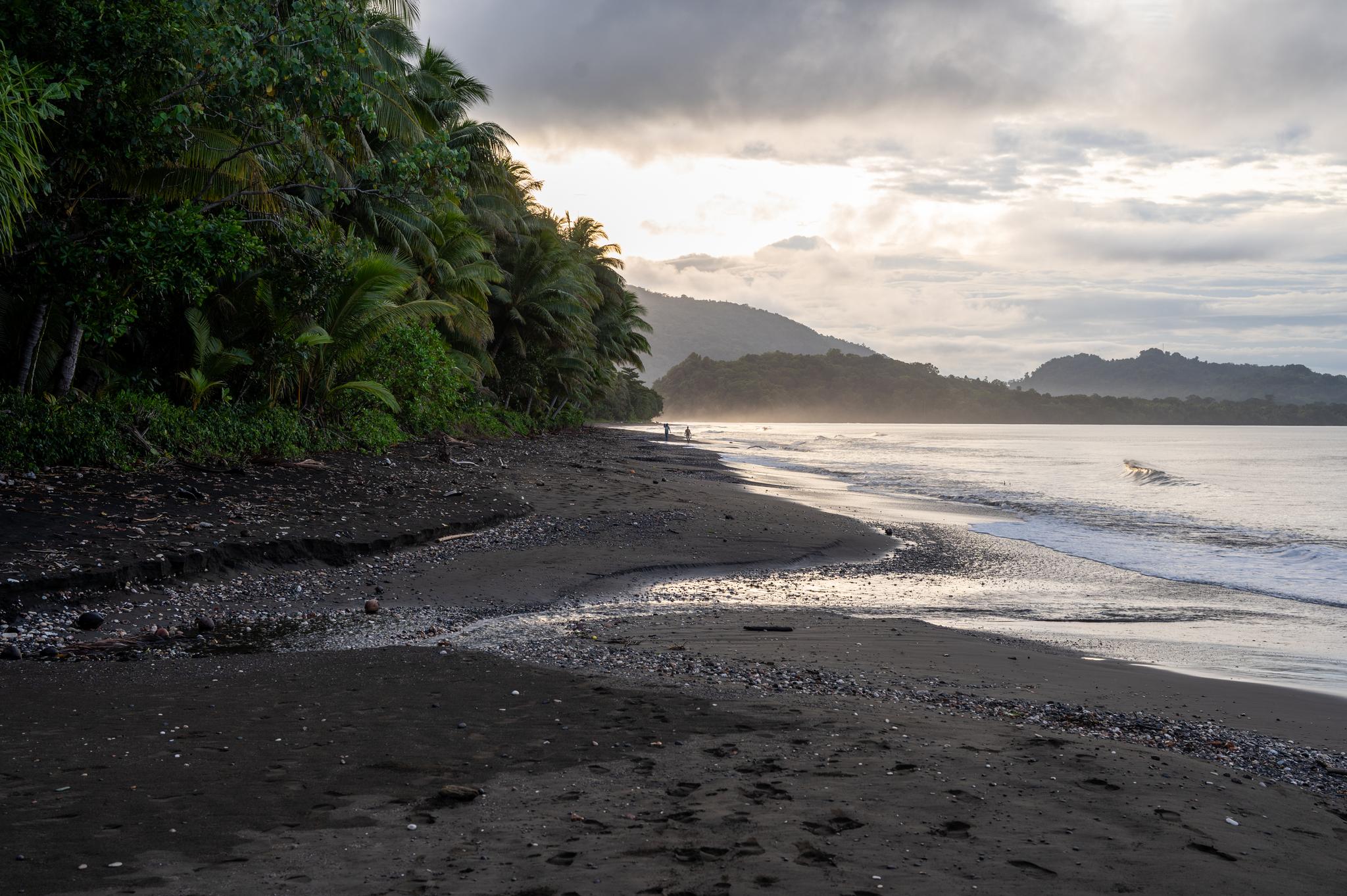
Leaders walk along a beach on Malaita in the Solomon Islands. Credit: Rudo Kemper, Conservation Metrics
Additional Sites
In addition to the profiles above, exciting work is happening across other Project Centinela sites. Teams are applying innovative uses of Planet data to halt and reverse drivers of biodiversity loss, including building resilient climate corridors in the Osa Peninsula in Costa Rica, monitoring deforestation and supporting smallholder farmers in Virunga National Park in the Democratic Republic of the Congo, and mapping water and grassland dynamics for tiger conservation in the Terai Arc Landscape in Nepal.
Heading Into Year Two
As a PBC, Planet takes impact assessment seriously, and Project Centinela is supported with rigorous quantitative and qualitative evaluations. And these results inform the program: in the next year, we will increase wraparound services, including new tools and webinars with Centinela sites and teams. It also helps us target our work: we are currently prioritizing sites in Europe, Oceania, and North America, and seeking sites in coastal ecosystems. You can read more about the early results of the program in our 2025 Impact Report.
Beyond new sites, we plan to take the lessons we’ve learned from our initial teams and develop shared resources and guidance for common use cases – scaling the power of satellite data for biodiversity beyond this digital public good program. We expect to continue collaborating with a number of Project Centinela site teams to support sensor fusion for biodiversity intelligence. Project Centinela sites are leveraging AI techniques to integrate advanced in-situ sensors with Planet satellite data to develop near-real time, holistic understanding of ecosystem condition and conservation efficacy.
Join Us and Help Protect Global Biodiversity
The goal of Project Centinela is to help leaders and stewards around the world protect at-risk biodiversity for the benefit of communities and future generations. And we need you to do it. Planet continues to accept expressions of interest from teams with a long-term say or a stake in vulnerable, high-biodiversity sites around the world: apply today!
Ready to Get Started
Connect with a member of our Sales team. We'll help you find the right products and pricing for your needs.