Manhatten, July 15, 2016

Tagged by: Farms

Understanding the Downstream Impacts of On-Farm Reservoirs

Paper

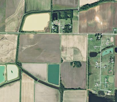
On-farm reservoirs play a critical role in crop irrigation. They store water during the wet season for subsequent use for crop irrigation during the dry season. In the U.S. alone, there are an estimated 2.6 million such reservoirs. However, storing this water has poorly understood impacts on downstream hydrology and ecosystems. The […]

Fusing PlanetScope & Sentinel-2 for Daily, High-resolution Leaf Area

Paper

Improving crop yields, vigor and health, can be facilitated by better monitoring of the cross-sectional area of vegetation—i.e., Leaf Area Index or LAI. However, measuring LAI on the ground is time consuming and expensive. Sentinel-2, operated by the European Space Agency, publishes a global LAI product; but at 10m resolution and a […]

PlanetScope Time-series Used to Understand Vegetation Phenology

Paper

Change in vegetation color, chemistry and metabolic activity is one of the most striking signals of life in our biosphere. Satellite imagery plays an important role in effectively retrieving and mapping these vegetation changes over time—also called phenology. The rapid revisit period of the PlanetScope cubesat constellation provides researchers with a unique […]

Semi-arid Rangeland Phenology Revealed with the Planet Dove Constellation

Paper

Temporal resolution is one of four axes by which one may judge the value of a remote sensing data source. Unlike spatial, spectral and radiometric resolution, temporal resolution can be used to decompose the day-to-day dynamics of ecosystems, revealing their phenology—the natural processes by which ecosystems (particularly vegetation) change over time. A […]

Sowing Date Detection with the Planet Dove Constellation

Paper

The date of sowing (or planting) of an agricultural field has an enormous influence over crop health and yield. With climate change, in many cases alteration of sowing dates may be critical for adapting to changing temperature and precipitation. Sowing too early can increase the risk of frost damage, while sowing too […]

High Spatiotemporal Retrievals of Crop-Water Use for Precision Agriculture

Paper

Global agriculture implicates roughly ¾ of all freshwater use on Earth. With demand on the global food supply increasing with population growth, and agricultural systems falling under greater stress due to climate change, water security is under increased risk. Remote sensing of evapotranspiration—the amount of water evaporated off, or transpired by vegetation—offers […]

On-orbit Wine Tasting? Monitoring Vineyards with Planet Satellites

Paper

Lianas—woody vines, including grapes—are structural parasites. Climbing on their hosts to get to the sunlight means lianas can spend less energy supporting themselves, devoting more to producing leaves and fruit. The risk is that their wood is less robust to stress, like freezing cold temperatures. As the water in the plant’s veins […]

Daily, High-resolution Leaf Area Index from Sensor Fusion with Planet, Landsat and MODIS

Paper

Classic remote sensing for agricultural relies heavily on indices like NDVI (Normalized Differential Vegetation Index), which uses information from the red and near-infrared portions of the spectrum to provide an indicator of vegetation greenness and vitality. However, other indices, often implicating other parts of the spectrum, may provided added and actionable information […]

Sensor Fusion of Planet, Landsat and MODIS Data for Unprecedented Land Surface Monitoring

Paper

In the midst of a revolution Earth Observation, due to increasingly diverse and temporally dense data feeds enabled by cubesats and other sensors, there is a need to be interoperable across sensors. In the journal Remote Sensing of Environment, Rasmus Houborg and Matt McCabe present the Cubesat-enabled Spatio-Temporal Enhancement Method (CESTEM), which […]

Insights into Vegetation Dynamics and Terrestrial Evaporation

Paper

Planet’s constellation of satellites, with daily revisit rates and sub 5 m resolution, provides the ability to overcome the usual spatiotemporal restrictions associated with traditional remote sensing. Matt McCabe and team explore the suitability of Planet imagery for an array of retrieval opportunities pertinent to hydrology, including leaf area index (LAI) and […]