Forest and Fields, July 18, 2016

Tagged by: RapidEye

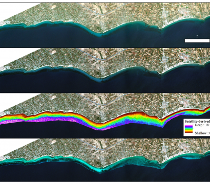
RapidEye Imagery Used to Monitor Suspended Sediments in Tropical Rivers

Paper

The flow of suspended sediment—fine particles carried by the water column—varies widely in tropical rivers, and can influence water availability, silting of reservoirs and pollution. Monitoring sediment loads over large rivers can be difficult with ground stations, making remote sensing a preferred solution. However, high spatial and temporal resolution are required to […]

Convolutional Neural Networks used to Detect Landslides in RapidEye Imagery

Paper

Landslides pose a major threat to people and property throughout the world, and particularly in landslide-prone regions. Improving our ability to monitor those landslides can improve mitigation, and may ultimately reveal approaches that could predict certain types of landslides in the future. Omid Ghorbanzadeh, from the University of Salzburg, and his team […]

Forest Biomass Monitoring with the RapidEye Constellation

Paper

When working with forest carbon stocks and emissions, it is notable that there is no strictly “true” data. In order to directly measure carbon in forests, one would need to cut the vegetation, dry it, weigh it, chip it up, and push it through a mass spectrometer. This being a self-defeating enterprise, […]

Charting Karst Topography in the Black Hills Region of South Dakota and Wyoming

Paper

Straddling the South Dakota-Wyoming border, the Black Hills region is characterized by karst features—caves, sinkholes and other landforms created as water erodes dolomite and limestone deposits. Given the importance of water in creating karst formations, climate change has the potential to alter karst intensity. Barbara Theilen-Willige, Professor at Technical University Berlin, used […]

Stanford Students Deploy Deep Learning with Planet Imagery

Features

As Planet’s Education and Research Community continues to grow, students are increasingly working with Planet imagery in college courses. At Stanford University, several students recently utilized Planet imagery in Computer Science 230: Deep Learning. Ian Avery Bick, Dennis Wang and Ben Mullet examined deforestation near Kibale National Park in Southern Uganda, an […]

Shoreline Changes in RapidEye Time Series of Pecém Port, Ceará, Brazil

Paper

Shoreline geomorphology is the result of natural forces including tidal action and storm activity, as well as anthropogenic changes to coastal infrastructure that can alter shoreline evolution and stability. High temporal- and spatial-resolution imagery can increase our understanding of the mechanisms that lead to these changes, and determine the influence of human […]

Change Detection of Mediterranean Seagrasses Using RapidEye Time Series

Paper

Seagrass beds are one of the most important ecosystems in the Mediterranean region, supporting an enormous diversity of marine fauna. However, with anthropogenic influences including dredging and modification of shorelines, pollution and other drivers, seagrass ecosystems facing increasing threats. To improve monitoring of seagrass extent, Dimosthenis Tranganos and Peter Reinartz from the […]

Mapping Winter Cropped Area of Smallholder Farms

Paper

Fine-scale agricultural statistics are important tools for understanding trends in food production, especially in smallholder systems where heterogeneity in production is common. Satellite data is a key component to collecting these statistics for smallholder systems, though not without challenges such as complex sub-pixel heterogeneity, little to no available calibration data, and high […]

Mapping and Estimating Forest Area and Aboveground Biomass

Paper

Forest area and aboveground biomass estimates represent two fundamental parameters in forest resource assessments and for measurement, reporting, and verification under the United Nations REDD+ program. In research led by Erik Næsset, various remote sensing sources are comparatively analyzed to determine their precision in generating these estimates, aiming to improve upon the […]