
The LA Fires: Reflections on Disaster Monitoring and Mitigation, One Year Later
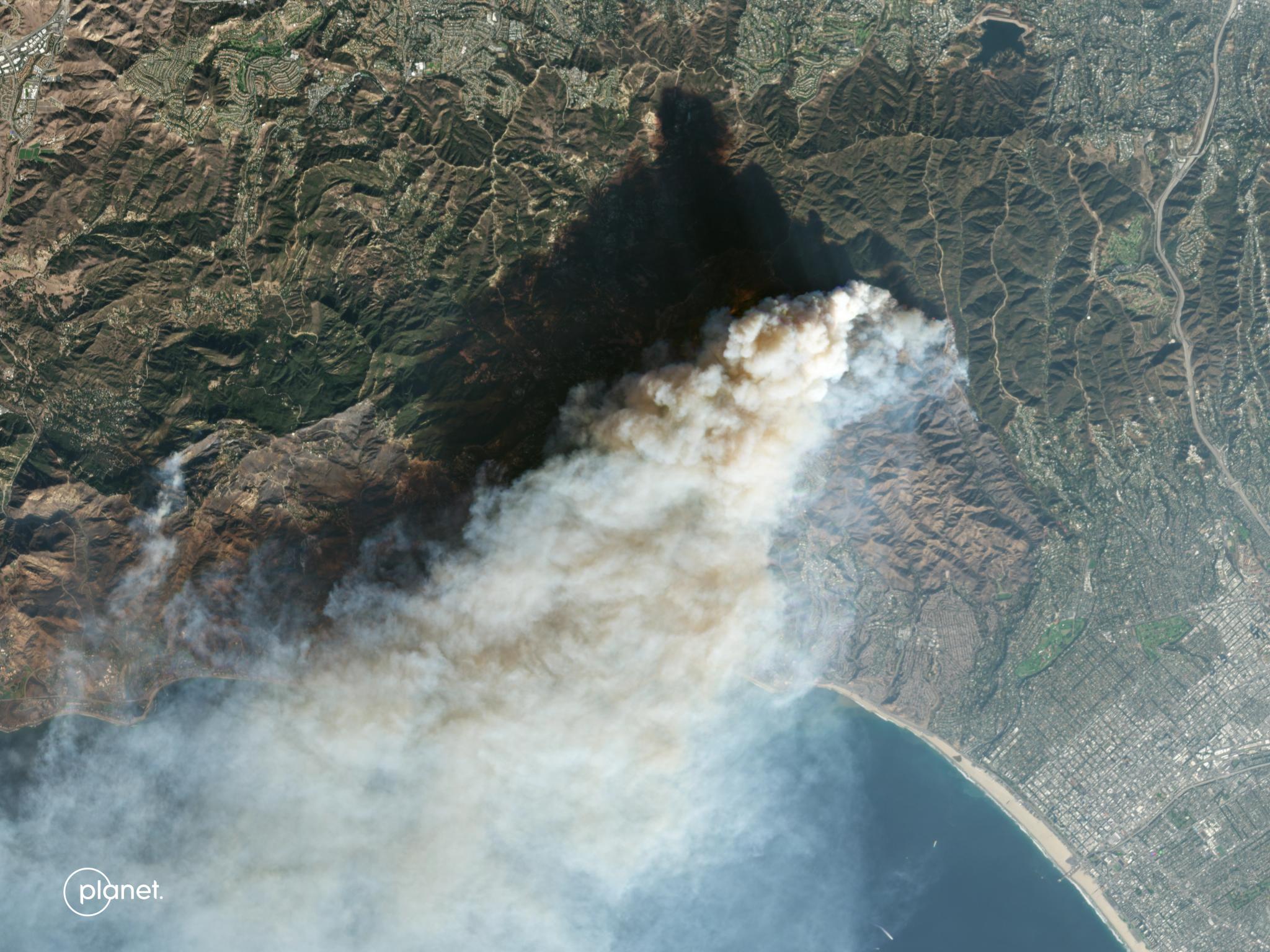
PlanetScope image of the Palisades Fire in Los Angeles County, California, captured January 9, 2025. © 2025 Planet Labs PBC. All Rights Reserved.
StoriesArticle contributors: Andrew Hassanali and Anne Pellegrino.
One year ago, Los Angeles suffered the most damaging wildfires in the region’s history, primarily impacting the communities of Altadena and the Pacific Palisades. Our thoughts are with the people impacted and those working tirelessly to rebuild.
As more communities expand into the wildland-urban interface, governments need new tools to increase preparedness and accelerate response efforts. Planet offers a unique combination of daily satellite monitoring, responsive high-resolution tasking, an unmatched archive of historical imagery, and AI-enabled solutions for governments contending with more frequent and costly wildfires.
These capabilities helped empower agencies responding to the fires one year ago, and new tools are enhancing disaster preparedness efforts in at-risk regions.
Altadena and the Palisades, One Year Later
In the days immediately following the initial ignition events one year ago, we captured PlanetScope® and SkySat® imagery of the fires, producing visual and spectral records of the fires’ boundaries and impacts. Captured between January 8 and January 10 last year, these images show the early devastation unleashed by the fires in the Altadena and Palisades areas. Planet imaged the same areas in December, about one year later, highlighting the early stages of recovery.
PlanetScope images of the Palisades Fire impact on January 9, 2025, and early recovery on December 15, 2025.
PlanetScope images of the Eaton Fire impact in Altadena, California on January 10, 2025, and early recovery on December 19, 2025.
SkySat images of the Palisades Fire impact on January 8, 2025, and early recovery on December 28, 2025.
Rapid Building Damage Assessment
The initial timeline of the Palisades Fire reveals how Planet data helped authorities fill critical information gaps and allocate resources. Following the fire’s ignition on January 7, and before airplanes were cleared for aerial flyovers to collect imagery, Microsoft’s AI for Good Lab used Planet data to deliver an early estimate of the number of structures damaged or destroyed by the fire (first made available on January 9). Planet also began sharing wildfire imagery through its Disaster Data portal as soon as January 9, making timely data available to better inform mitigation and response.
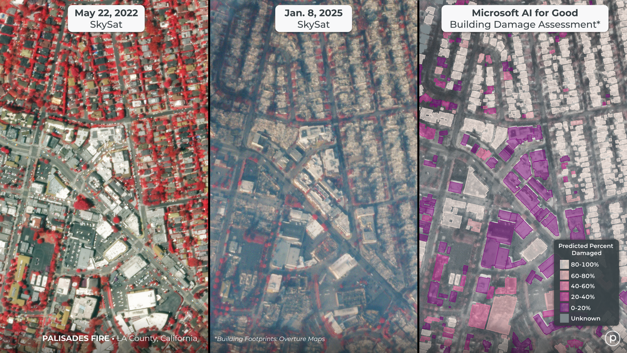
Building damage assessment produced by Microsoft’s AI for Good, using Planet data.
Planet’s unique combination of rapid response capabilities and a deep stack of imagery also empowered journalists working to uncover the fire’s origins. Reporters at The Washington Post analyzed Planet data, along with videos, photographs, and radio communications, and determined that the Palisades Fire ignited close to a burn scar left by another fire six days earlier. These reporters postulated that the larger Palisades Fire may have started when the Lachman Fire’s burn scar reignited, a theory that has now gained widespread acceptance. Wildfires that restart from the scars of recent blazes, sometimes called zombie fires, are an increasingly common and worrying trend, further reinforcing the need for consistent monitoring throughout the lifecycle of a fire.
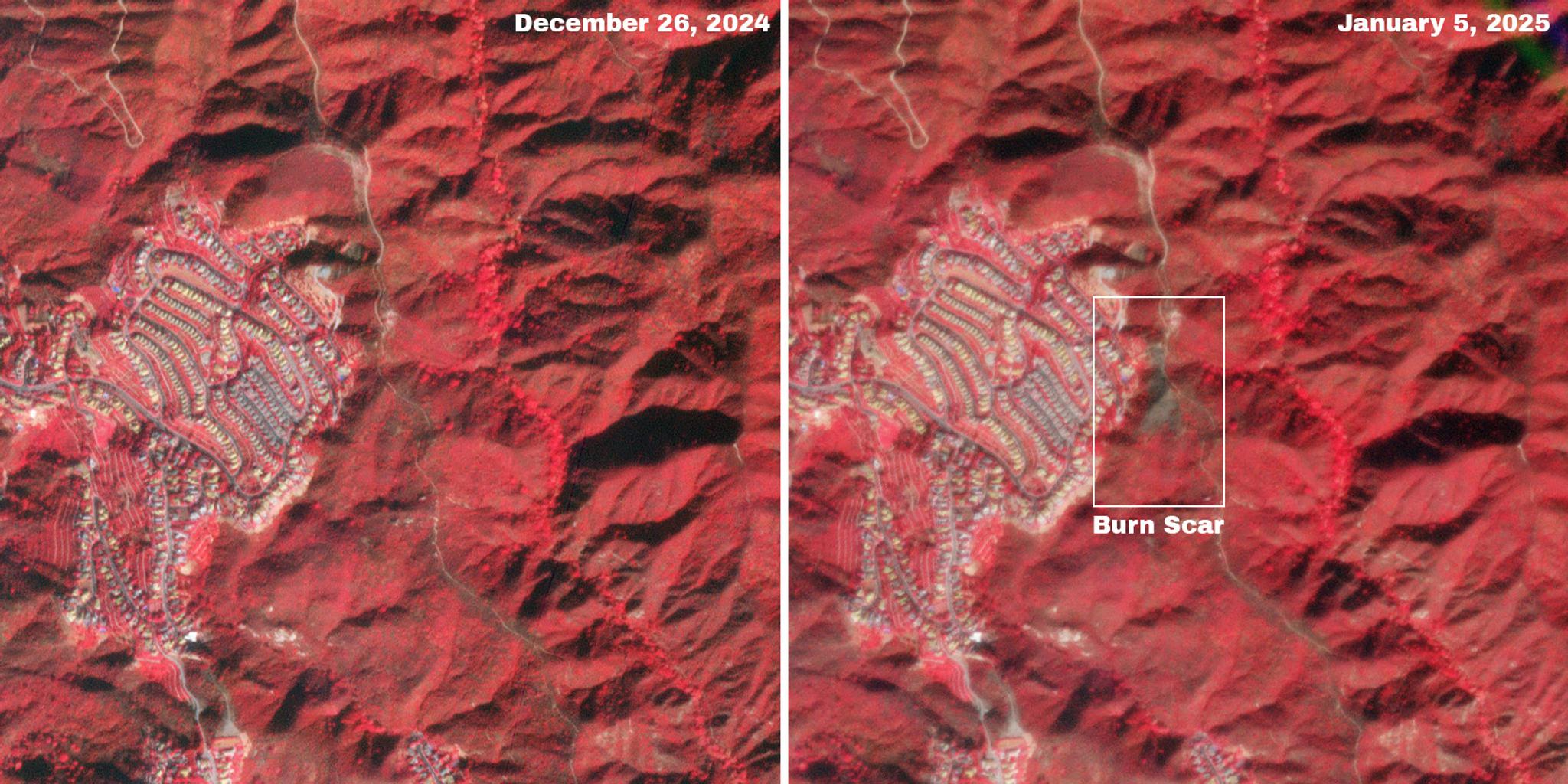
As analyzed by the Washington Post, the burn scar from the previous fire in the Palisades is visible in the January image from this pair of false-color PlanetScope images. In these images, healthy vegetation appears bright red, while burned areas and bare ground look brown.
Addressing the Wildfire Threat
While rapid response is vital, Planet data and solutions also play a crucial role in wildfire mitigation workflows, helping authorities better understand risk before events occur. Subtle changes in canopy structure or spectral signals can reveal early stress — such as drought-related dieback, pest outbreaks, or invasive species — long before signs are visible on the ground. High-resolution, near-daily imagery from Planet gives agencies the speed and detail needed to help detect these early warning signs and prioritize areas for investigation or intervention.
By monitoring vegetation health and dryness, agencies can assess fuel loads, identify ignition risks, and track illegal clearing that increases wildfire danger. Planet is developing a suite of data products intended to provide quantitative, science-backed metrics to assist with evaluating wildfire fuels and risks. To inquire about these upcoming products, please contact the Planet Sales team.
The Path Forward: Partnership and Innovation
As we reflect on the one-year anniversary of the historic and devastating fires in Los Angeles, we recognize that massive, deadly fires are occurring with greater frequency, making mitigation and monitoring critically important across commercial and government organizations. Planet is proud to join partners in applying cutting-edge technology to revolutionizing wildfire risk management, enhancing our ability to protect infrastructure, natural resources, and communities.
In addition to our work with customers and partners to address disaster risks, Planet’s Disaster Data program will continue to make select data available to qualified professionals working to respond during major natural disasters. You can learn more about our Disaster Data program and our constellations on our website.
Ready to Get Started
Connect with a member of our Sales team. We'll help you find the right products and pricing for your needs.