All Eyes on Marine Plastic From Orbit
New research combining Planet’s high cadence satellite imagery and other innovative technologies has successfully found the sources and pathways of plastic pollution in the Caribbean Sea. The study by Kikaki et al. (2020) not only shows how satellite remote sensing is an efficient and cost-effective tool for monitoring plastic debris, but it also shows the value of integrating satellite information into future ocean clean-up and protection efforts.
One of the most topical problems in marine pollution is microplastic debris, with an estimated 93 to 236 thousand metric tons of microplastic in our oceans as of 2014. Over the past 60 years, the accumulation of plastic debris has led to the formation of garbage patches—massive gyres of non-biodegradable plastic—and tons of microplastic seafloor sedimentation across global seawaters. Plastics are found not just in the ocean but in different trophic levels of the marine ecosystem, including over 50 percent of the fish species found in the American and Indonesian markets.

A boom is filled with plastic, and yet was only able to collect small amounts of it due to much of the debris passing it by. This image comes from this study and was provided by Konstantinos Karantzalos (National Technical University of Athens).
In order to investigate the capability of satellite sensors in detecting marine plastic debris, a team including Aikaterini Kikaki and Konstantinos Karantzalos (National Technical University of Athens’ Remote Sensing Laboratory), Caroline Power (citizen scientist) and Dionysios Raitsos (University of Athens-Department of Biology) utilized Planet data in a five year study observing the Bay Islands and Gulf of Honduras. This was the first-ever study that not only detected, but also tracked and mapped out plastic debris flow using high-resolution multispectral satellite imagery coupled with verification from in-situ, or on site, observations.
“While other studies have used remote sensing to identify plastic debris, our study dynamically tracks its movement, and can open up new doors for marine pollution monitoring and safeguarding our oceans,” says Konstantinos Karantzalos, associate professor at the Remote Sensing Lab.
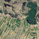
Drawing on multitemporal high-resolution satellite datasets from Planet along with Sentinel-2 and Landsat-8 collected over the Bay Islands, researchers were able to identify and verify plastic debris events. Over the course of 2016 to 2018, the total area of plastic debris detected skyrocketed from 0.23 km2 to 0.77km2. While researchers did not find one specific region where plastic accumulated, they did find scattered pathways of debris indicating the presence of circulatory ocean currents influencing plastic flows. Once plastics were detected through satellite sensors, on the ground observations and underwater imaging supplemented researchers in determining that river mouths, such as the Motagua River (Guatemala) and Ulua River (Honduras), were the primary sources of pollutants.

Planet imagery shows examples of sediment-rich water flowing into the Caribbean Sea, which was associated with discharges of plastic from the Motagua River in Guatemala after heavy rainfall on March 9, 2018 (left) and September 6, 2018 (right). © 2018, Planet Labs Inc. All Rights Reserved.
Planet’s near-daily imagery was crucial in overcoming the major barrier of cloud coverage that prevents researchers from obtaining clear images.
“Plastic debris flows are most prevalent following periods of rainfall, inevitably leading to heightened cloud coverage,” says Karantzalos. “With other types of satellite data, you get an image every 10 or 15 days, but with Planet you get an image every three days, so it increases your possibility to detect and track.”
This is also the longest-running plastic tracking study using satellite data and is a first for Planet’s data, which is constantly being integrated in innovative and impactful use cases around the world. The study indicates that in addition to changing the way we tackle ocean pollution, there is also potential for future research efforts to fuse machine learning algorithms with plastic debris detection efforts to create automated approaches. In the meantime, with microplastic continually being dumped into the ocean, this study strongly suggests that new recycling and integrated waste management systems must be set up for Guatemala and Honduras, encompassing the efforts of both citizens and industries.
Typically, temporary floating barriers called booms are deployed in ocean clean-up efforts to collect and contain pollutants. However, localized plastic build-up in water bodies can overwhelm booms and even cause them to break, impeding effective mitigation of pollution as plastics leak out or pass over the barriers. Using Planet’s archive of images and the tracking techniques outlined in the study, it’s possible to locate where debris originates from.
“Understanding sources, ocean currents and plastic pathways enables targeted clean-up campaigns that focus mitigation on areas where the debris is still manageable, before plastic accumulates into garbage patches or washes up on beaches,” says Dr. Joe Mascaro, director of Planet’s Education and Research Program. “The results of this study could totally change how we tackle ocean monitoring and environmental preservation going forward.”
To learn more about how Planet imagery can be used for academic research, check out our Education and Research program.
)