Closing the Management Gap: The Urgent Mandate for Persistent Marine Monitoring

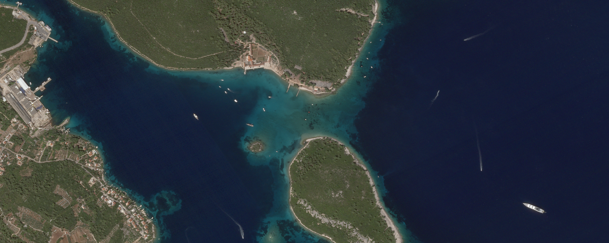
SkySat image of a marine protected area (MPA) around Badija and Korčula islands, Croatia, captured November 7, 2025. © Planet Labs PBC. All Rights Reserved.
StoriesThis article was written in collaboration with SeaCras.
Several years ago, two iconic beaches on Maya Bay in Thailand suffered catastrophic ecological collapse as a result of unmonitored mass tourism.
On a daily basis, hundreds of speedboats and thousands of visitors brought anchors, propeller strikes, fuel leaks, and oxybenzone sunscreens, killing more than 80% of the bay's coral cover. The Thai government was forced to completely close Maya Bay to tourists for over three years to allow marine life to begin to recover.
This is a cautionary tale for countless other marine ecosystems facing accelerated degradation from climate change, biodiversity loss, and unsustainable human activity. Despite ambitious UN 30x30 targets to protect 30% of the world’s oceans by 2030, traditional monitoring remains dangerously fragmented. Relying on periodic boat patrols and localized sampling creates "paper parks" — marine protected areas (MPAs) that exist as legal designations on maps but lack the persistent oversight necessary to identify human-induced environmental shifts. This results in critical gaps that allow damage to take root long before it’s detected, making environmental restoration far more expensive, damaging public trust, and putting policy goals out of reach.
To protect marine ecosystems efficiently, government agencies need persistent, daily observation paired with scientifically validated analytics.
From Monitoring to Measuring
For civil government leaders, the mandate has moved beyond observation, to urgent policy requirements for protection and enforcement across vast maritime boundaries. This creates a gap between current monitoring practices and what is, or will be, expected.
As we highlighted in an earlier blog on marine protection, the transition from reactive sampling to proactive monitoring is the missing link in global biodiversity efforts, making immediate, data-driven intervention more vital than ever to building global resilience.
Satellite imagery allows agencies to identify and understand change, as it’s happening.
Planet operates a daily broad-area constellation capturing 3.7 m spatial resolution observations across coastal zones and ocean boundaries. This continual cadence creates a high-frequency baseline to spot sudden or subtle changes across vast maritime areas.
Planet partner SeaCras delivers an integrated software solution that helps translate this imagery into defensible intelligence to support policy enforcement and justify public spending. It covers biochemical parameters, MARPOL pollution indicators, maritime activities, coastal changes, and ecological risks and vulnerabilities. By applying peer-reviewed algorithms to satellite data, SeaCras shifts the conversation from generic collection to actionable, scientific-grade accuracy.
This approach has been applied in peer-review research, including a recent study in Scientific Reports focused on extreme algal bloom events, known as mucilage. PlanetScope imagery and other data from the northern Adriatic Sea were analyzed in part with SeaCras tools. A striking finding was that between the floating mucilage aggregates, the sea behaved completely normally — as if there were no algal blooms whatsoever — even just 50 meters away. Conventional Earth observation technologies relying on low- to medium-spatial-resolution sensors produced insufficiently accurate event classifications, which ultimately led to incorrect conclusions.
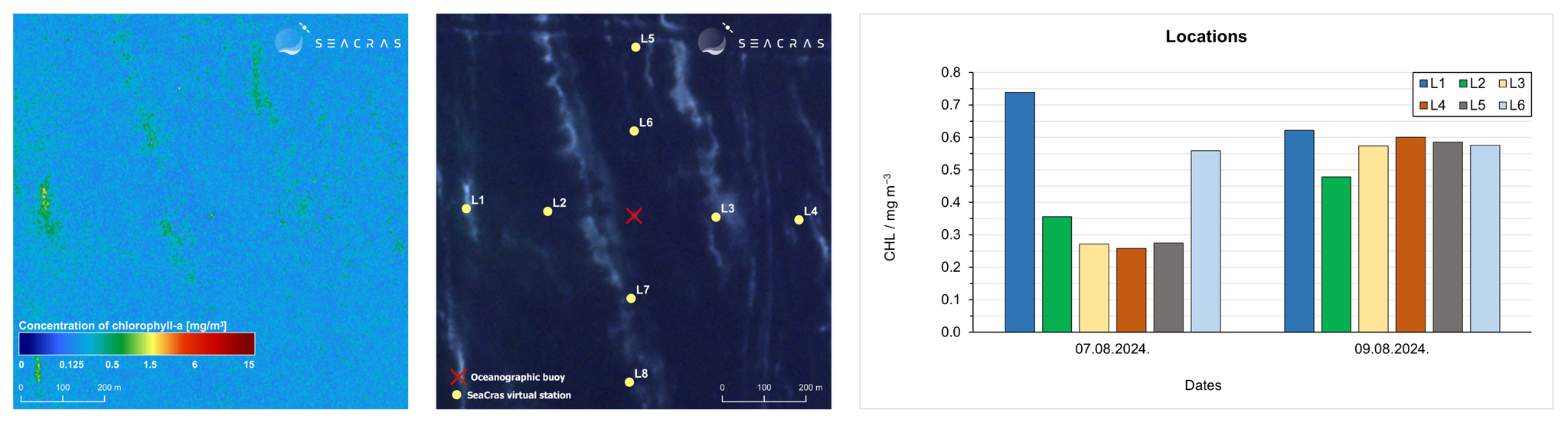
These images from SeaCras demonstrate their research approach. PlanetScope imagery was processed to derive bio-optical variables, including chlorophyll-a and red-edge reflectivity, with satellite-derived parameters subsequently validated against measurements from an oceanographic buoy. The results showed that extreme mucilage events exhibit enormous spatial variability at the sub-100-meter scale, as well as on an hourly timescale.
For government agencies, this underscores the value of reliable data at scale, so that a normal sample from an isolated area doesn’t lead to the assumption that the same conditions exist elsewhere. And it allows agencies to move from data as a commodity to data as actionable intelligence, giving policy makers the defensible science required to report on national goals.
From Regional Research to National Resilience
Every MPA has normal seasonal noise — temperature swings, sediment from spring runoff, and algae that blooms and recedes on its own. The hard part isn't spotting change. It's telling the difference between that normal noise and an actual threat: an unpermitted discharge, a harmful algal bloom that isn't going to recede, or an unauthorized vessel.
Sparse observations make this distinction largely speculative, whereas a daily time series delivers the clarity needed for confident decision-making. AI-powered automated change detection in the SeaCras platform flags the anomalies as they happen, so inspection and sampling teams can be deployed only where the data suggests something is wrong.
SeaCras, with daily PlanetScope data, makes it possible to identify and validate threats at scale. In 2025 alone, SeaCras identified and documented over 150,000 illicit anchoring, pollution, and seabed devastation events over protected Posidonia oceanica seagrass meadows and corals across marine protected areas (Natura 2000 sites) in only three Croatian counties. This revealed that regional government authorities — and, in practice, pretty much everyone — had previously been blind to the true scale and intensity of these activities and their impact on protected marine ecosystems.
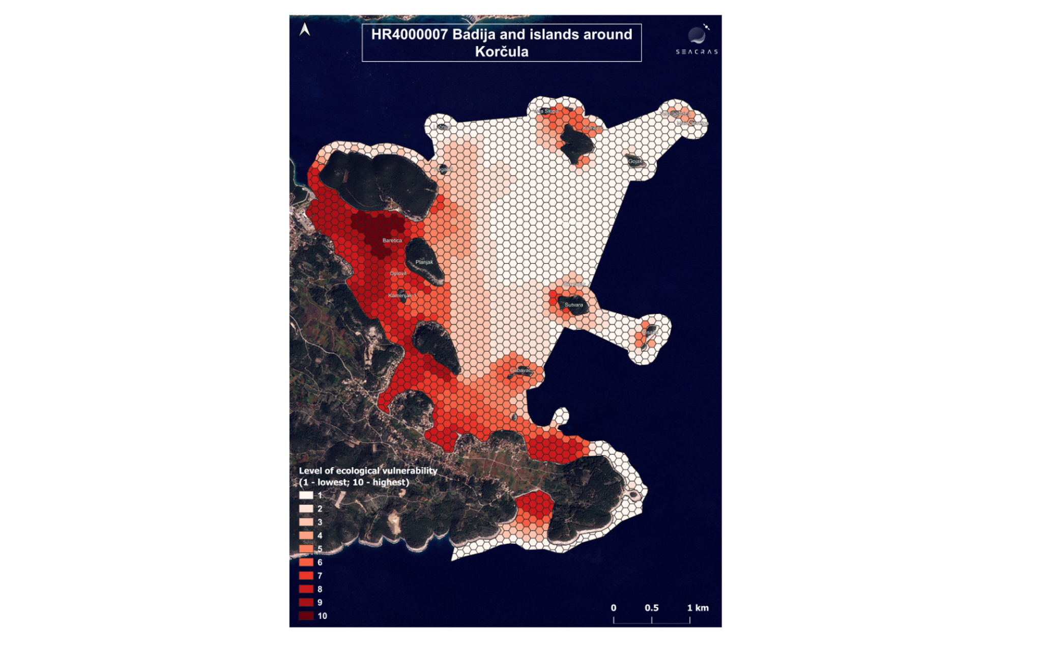
Ecological vulnerability of the MPA: Badija and Korčula island, Natura 2000 site, Site ID: 555578798.
When considering illicit fishing specifically, one challenge is that over 90% of maritime traffic in Croatia consists of vessels under 16 m in length, which are generally not obliged to have AIS (Automatic Identification System) turned on, making them difficult to sanction and control. This also makes it difficult to estimate their total emissions and related environmental impact. The SeaCras continual monitoring service detects marine and maritime activities at national levels, making it possible to track all relevant ship movements and their impact.
Continual monitoring also provides authorities with the evidence needed to decide where limited conservation and restoration resources can have the greatest impact.
In one such analysis for Dubrovnik-Neretva County, SeaCras identified a marine protected area where ecosystem degradation had progressed beyond the point at which further restoration investment was likely to deliver any results. At the same time, the analysis found several pristine areas that needed to be preserved, allowing decision-makers to redirect limited resources toward locations where restoration and preservation efforts had a significantly greater chance of success. This saved the client more than €150,000 in potential restoration costs at a single location. This is support for nature restoration plans at its best—both ecologically and economically.
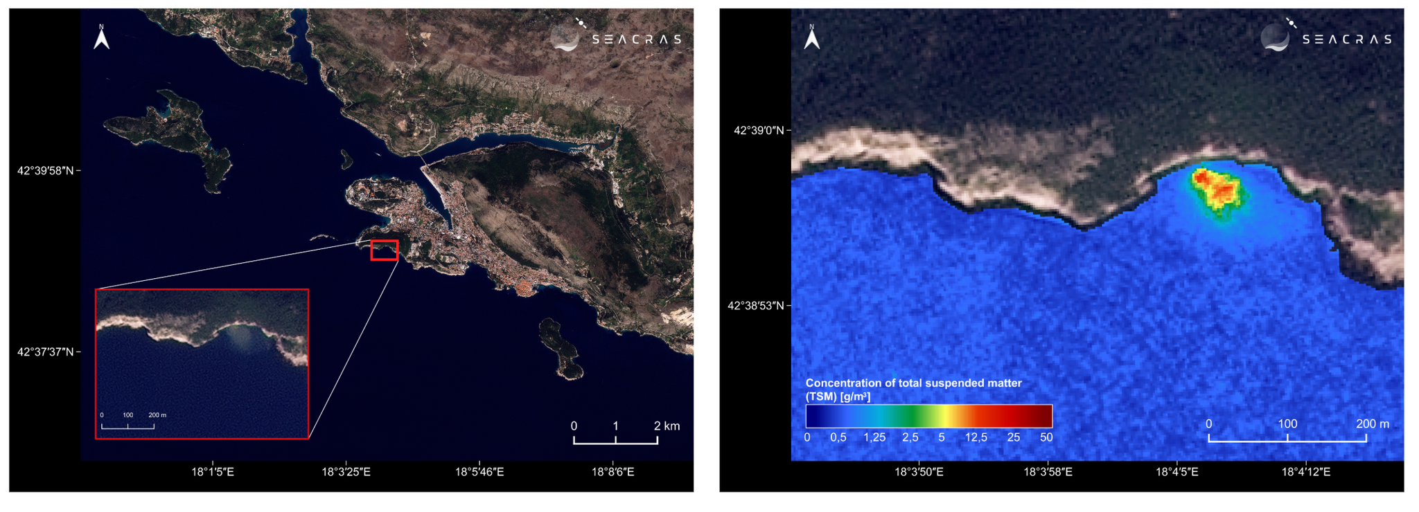
Satellite-derived mapping of total suspended matter (TSM) identifying a sewage discharge plume off the coast of Dubrovnik, highlighting the precision of daily monitoring for pollution source identification.
By using persistent monitoring as infrastructure, instead of as an occasional check-in, agencies can scale insights across their entire coastline.
Building the Future of the Blue Economy
Governments are currently finalizing budgets ahead of the fall spending cycle, making this the moment to present the case for persistent monitoring as core infrastructure, not a discretionary add-on.
Integrating Planet daily coverage with the SeaCras intelligence layer, simplifies decisions for agency leaders. Instead of managing raw datasets, civil government teams gain clear, decision-ready inputs that plug directly into existing policy workflows.
You cannot manage what you only see occasionally. SeaCras provides seamless delivery of intelligence data layers to clients immediately after Planet satellite data becomes available, giving authorities and managers a holistic picture of what is happening in their waters, to allow them to prepare for and respond to both human pressures and natural events, while lowering cumulative costs.
Persistent observation plus calibrated science is how agencies close the management gap on paper parks, meet their biodiversity commitments, and protect the blue economy they're responsible for.
Ready to modernize your marine stewardship? Contact us to learn more.