A Comprehensive Guide to Broad Area Management Through Satellite Imagery

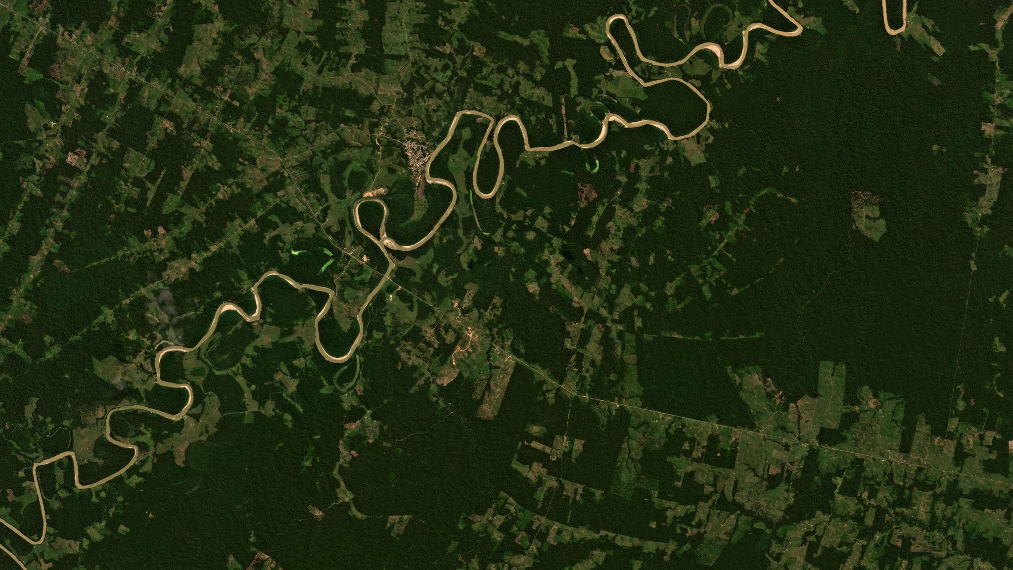
PlanetScope basemap of a broad area in western Brazil from the week of June 27, 2022. Comparing this basemap with an earlier one for the same area of interest allows you to look for change. © 2022 Planet Labs PBC. All Rights Reserved.
TechLearn how governments and organizations leverage broad area management to monitor change across vast geographies and timescales.
Organizations across various sectors increasingly rely on real-time data and actionable insights to make informed decisions. Whether managing agricultural lands, monitoring natural resources, detecting threats, or overseeing vast infrastructure networks, the ability to efficiently observe, analyze, and manage broad areas of the Earth is crucial. This is where Planet comes in.
Planet offers a unique set of products — including daily Earth data, high-resolution tasking, advanced analytics, and powerful APIs — that support broad area management by providing a multidimensional view of change as it’s happening.
This guide explores how Planet’s broad area management capabilities allow governments and organizations to look broader, closer, deeper, and back in time to identify and address new challenges and make better decisions.
Table of Contents
- Understanding Broad Area Management
- Broad Area Management Capabilities: Four Superpowers (Broader, Back, Closer, Deeper)
- Planet Products: The Broad Area Management Toolkit
- How Broad Area Management Is Used by Governments (Civilian and Military)
- How Broad Area Management is Used by Commercial Operations
- Future Trends in Broad Area Management
- A Holistic Approach to Broad Area Management
Understanding Broad Area Management

Broad area management is the practice of monitoring, measuring, and reporting change across large, dispersed geographic areas and timescales using Earth observation data.
This approach enables governments and organizations to gain insights into various natural processes and human activity, such as environmental changes, land use, and infrastructure development.
Broad area management is best achieved with scalable data, analytics, and software that capture multiple dimensions of information in near-real time — including location, time, and physical characteristics.
By leveraging high-frequency satellite imagery and advanced analytics from Planet, broad area management can help detect early threats, mitigate risks, ensure regulatory compliance, and improve disaster preparedness.
Broad area management from Planet includes four distinct capabilities which help enhance decision making. It allows organizations to:
- Look broader and monitor vast areas every day with daily satellite imagery
- Look back and identify changes with AI-powered alerts
- Look closer with high-resolution tasking imagery
- Look deeper with analytics-ready derived data
The Value of Broad Area Management
Historically, many organizations and agencies have relied on public satellite imagery, aerial surveys, in-field sampling, and other remote sensing to collect data across. But these tools aren’t enough to keep pace with changes fueled by climate change, population growth, new compliance requirements, and rising geopolitical tensions — especially in inaccessible or difficult to access areas.
Traditional data sources like drones and aerial imagery are often not collected frequently enough to spot changes early. Legacy IT systems often depend on highly manual processes, which can create analysis and reporting bottlenecks. And staffing shortages can make it even more difficult to scale up data collection and analysis.
Broad area management from Planet provides up-to-date, daily, and detailed insights into changing conditions.
Governments use these insights to support routine operations like permit compliance and code enforcement, implement new policies and programs, and coordinate responses to unplanned events like natural disasters and illegal activities. And use cases across commercial operations range from minimizing underwriting risk and increasing crop productivity to monitoring infrastructure development.
Ultimately, broad area management helps organizations across industries achieve a range of shared outcomes, including:
- Real-time monitoring and alerting of critical areas
- Faster issue discovery and decision-making
- Ability to do more with current budgets
- Increased efficiency and productivity of remote sensing workflows
- Streamlined data integration and analysis processes
Broad Area Management Capabilities: Four Superpowers
Broad area management brings together four distinct capabilities, or superpowers, to look broader across the landscape with daily monitoring, look back in time with our living archive, look closer at an area of interest with high-resolution tasking, and look deeper to see signals and patterns that fall outside the visible spectrum. Let’s take a look at each.
Looking Broader: Monitoring and Measuring Change Across Vast Geographic Areas
Basing decisions on data that is too narrow can have negative and even dangerous consequences — ranging from the loss of precious resources and funds to unnecessary suffering.
Monitoring large geographic areas is possible with Planet Monitoring — a fleet of 3.7 meter resolution (GSD) Dove® satellites that orbit the globe approximately every 90 minutes, capturing Earth’s landmass and coastal areas on a near-daily basis.
This continuous global coverage means there is PlanetScope® satellite imagery available almost anywhere it’s needed, so you can broaden your focus to include adjacent geographies immediately.
This additional context can eliminate assumptions in choosing the path forward — allowing teams to act with confidence and agility.

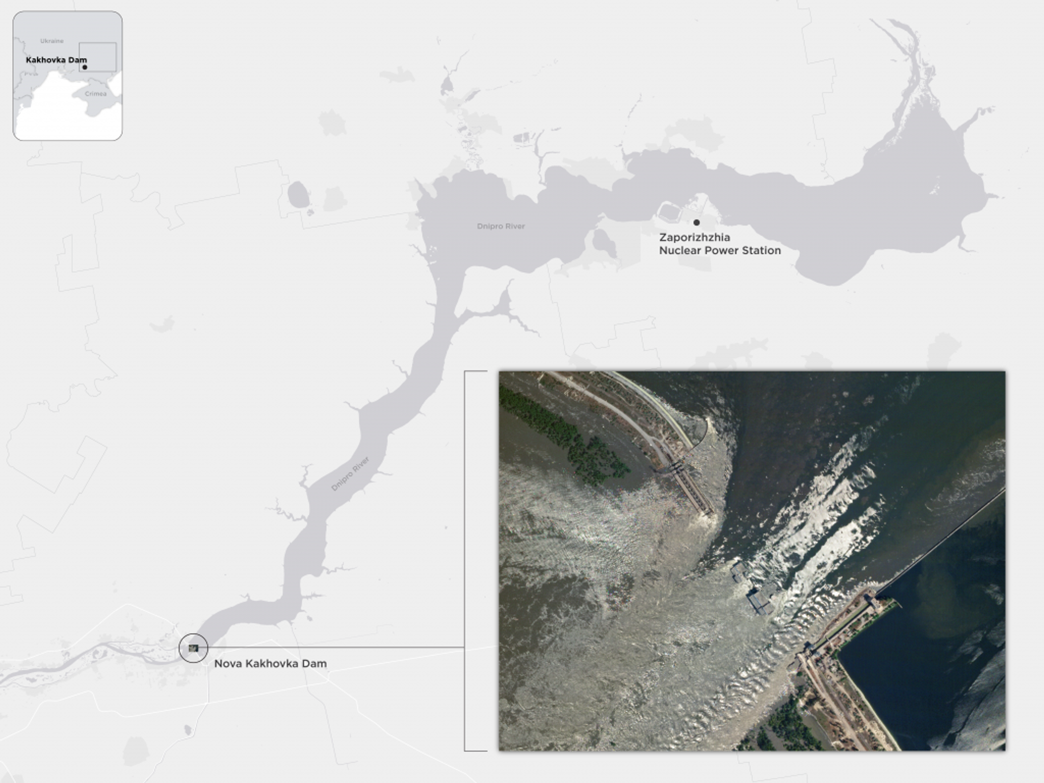
In early June 2023, the Nova Kakhovka dam across the Dnipro River in Ukraine collapsed, flooding several downstream cities. This high-resolution SkySat® image taken on June 6 captures the aftermath of the collapse in great detail. But it lacks the broader view — demonstrated by the background map.
This time series of Planet Basemap images spanning May to July 2023, gives insights into the broader and potential downstream consequences of the collapse.
Looking Back: Utilizing Earth Observation Data for Better Decision-Making
Planet operates hundreds of satellites that index the entire surface of the Earth nearly every day and feed the ever-growing Planet Archive — composed of more than 300 billion sq km of imagery, with proprietary datasets back to 2009 and public datasets back to 1972.
This means that for any given location on Earth’s landmass, the archive has an average of over 2,700 images of that area.
This unprecedented, living dataset of global change allows organizations to compare current conditions with those in the past to understand patterns in areas of interest, validate hypotheses of what is happening on the ground, and model future scenarios with confidence.
And these capabilities are magnified when combined with analytics and automation. Planet Analytic Feeds transform daily satellite imagery leveraging AI into sources of information that identify and classify buildings, roads, vessels, aircrafts, and other objects. When applied to the Planet Archive dataset, change can be detected efficiently over large periods of time, at scale.
The construction of the Felipe Ángeles International Airport near Mexico City between January 14, 2017 and January 27, 2024 — captured in 364 PlanetScope scenes.
Looking Closer: High-Resolution Tasking for Detailed Inspection
Broad area management often begins with an expansive view that is refined once a change or specific area of interest is identified.
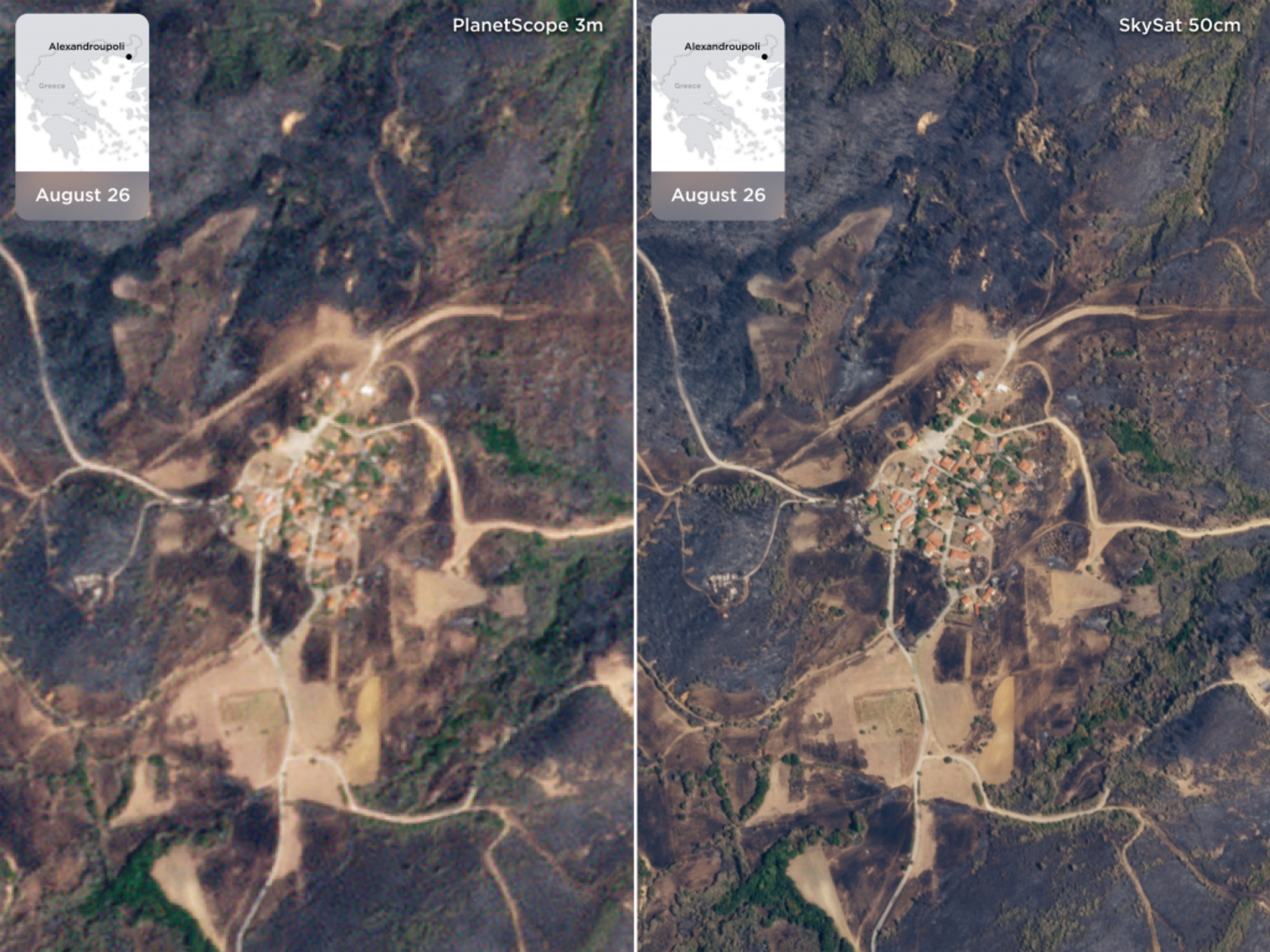
Then, when an even closer look is needed, Planet Tasking via the SkySat constellation offers satellite imagery at 50 cm resolution — which captures images with incredible clarity, revealing features as small as a tree.
This process of constant monitoring with always-on Earth observation data, paired with on-demand high-resolution tasked imagery, is called “tip and cue” — and it can be a powerful tool for organizations across industries.
With the ability to task satellites on-demand and rapidly capture high-resolution images, users gain access to near real-time information when they need it most.

A comparison of PlanetScope and SkySat images of Alexandroúpolis, Greece illustrates the value of looking closer, in a higher resolution.
Looking Deeper: From Imagery to Measurements With Planetary Variables
Many Earth observation satellites image in multiple spectral bands, which means they’re capable of not just “true color” imagery, or imagery that looks like what a human eye would see, but also probe various segments of the electromagnetic spectrum.
And when this capability is applied to broad area management, we’re able to understand physical attributes across the Earth in a much deeper way. Through multispectral analysis across space and time, we’re able to look deeper and convert raw observations into quantifiable metrics.
Planetary Variables are Planet’s analysis-ready data products that are derived from sources across the electromagnetic spectrum, including optical, radar, passive microwave, and LiDAR sensors.
By fusing these distinct sources together with Planet imagery and tools, Planetary Variables unlock information about key characteristics that drive deep insights for a range of use cases, including:
- Agricultural monitoring: Cloud-free Crop Biomass data and Soil Water Content data help farmers and agricultural companies detect nutrient deficiencies, pests, diseases, and generate prescription maps for seeds and fertilizers. Field Boundaries trace the boundaries of agricultural parcels to help aid in food security, supply chain management, and commodities trading.
- Forest and land management: Forest Carbon offers up-to-date, accurate, and finely resolved measurements of the aboveground carbon stored in forests. This helps enable quantification of carbon stocks and regulation of forest degradation.
- Water resource monitoring: Soil Water Content data is used to help build models and make informed decisions about irrigation needs, drought risk, and ecosystem restoration projects. Land Surface Temperature helps monitor hot and dry conditions to track the feedback loop of drought, in addition to agriculture uses and commodity and yield prediction.

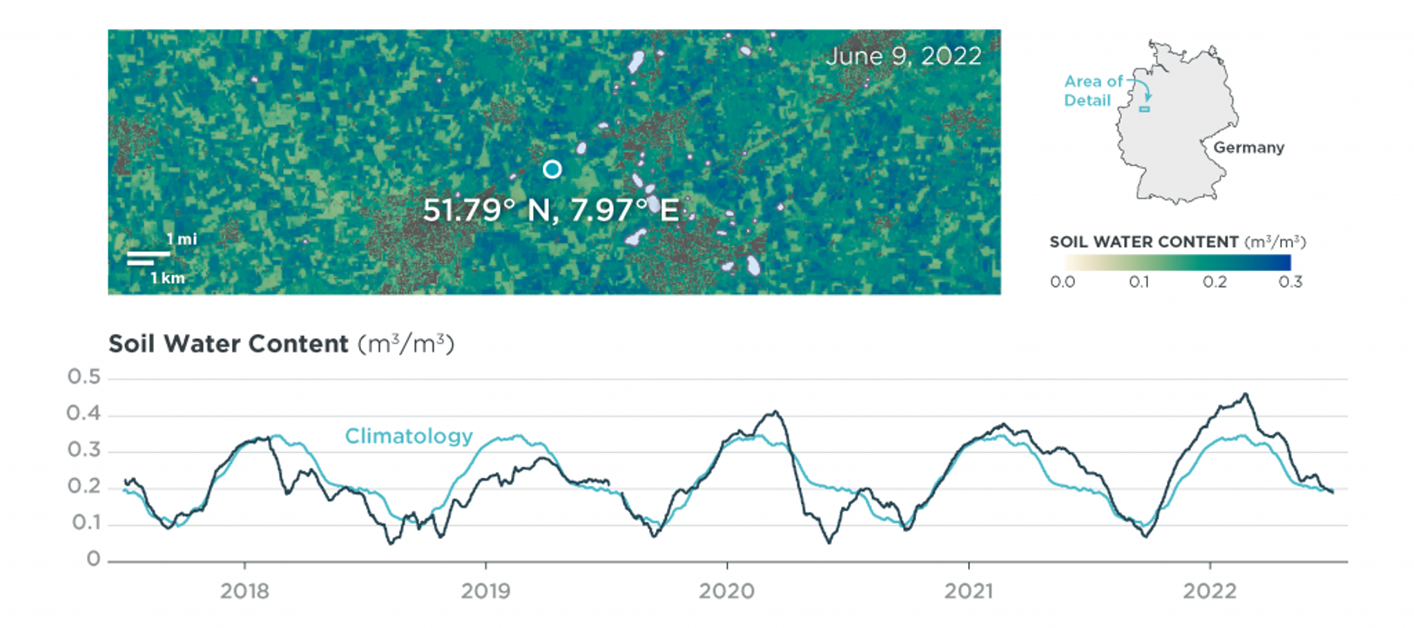
Soil Water Content allows organizations to monitor complex water systems by providing insights in water demand and storage capacity. Planet processes data from satellite sensors that measure passive microwave radiation, delivering near-daily measurements. Pictured here are measurements of soil water content near Ahlen, in North Rhine-Westphalia, Germany.
Planet Products: The Broad Area Management Toolkit
Better information means better decisions. Planet products support broad area management for every location on the globe.
Planet Monitoring
Hundreds of PlanetScope satellites image nearly all of the Earth’s landmass on a daily basis, at 3.7 m resolution. Analysis-Ready PlanetScope data makes it easy to conduct deep time-series analysis, and Planet Basemaps provide seamless, up-to-date mosaics. These products provide a broad, near-daily view of any area of interest.
Planet Tasking
The SkySat constellation provides additional clarity for any area of interest with imagery at 50 m resolution and sub-daily revisit. These images allow for a closer look, when needed.
Planet Archive
The Planet Archive is composed of more than 300 billion sq km of imagery, with proprietary datasets back to 2009. It is a living dataset for any given location on Earth’s landmass — providing the ability to look back in time.
Planet Analytics
These products leverage machine learning to detect objects like roads, buildings, ships, and aircraft — transforming imagery into actionable information feeds. When combined with Planet PlanetScope and Archive data, these products can detect change over broad areas and timescales.
Planetary Variables
These analysis-ready data feeds draw on numerous constellations to measure important conditions outside the visible spectrum, including:
- Soil Water Content: Provides high-resolution measurements of the water content of the soil, unhindered by clouds.
- Land Surface Temperature: Provides high-resolution measurements of the skin temperature of the surface of the Earth.
- Crop Biomass: Provides daily, cloud-free estimates of crop biomass.
- Field Boundaries: Includes a set of polygons that represents the boundaries of agricultural fields for any areas of interest.
- Forest Carbon: Provides timely, operational, near-tree-scale insights into global changes in canopy height, canopy cover, and aboveground carbon density.
These measurements provide a deeper look and understanding of changing conditions of the Earth’s surface.
Planet Insights Platform
The set of applications, APIs, data layers, and tools that help customers and partners create insights that characterize our changing physical Earth.
The platform empowers developers, data scientists, and GIS teams to perform pixel-based analysis, calculate statistics, and prepare data for machine learning workflows on a global scale.
Planet Insights Platform supports broad area management by providing a central place for Earth data, analytics, and tools — to look broader, back, closer, and deeper.
How Broad Area Management Is Used by Governments
Governments have been early and active users of Planet data. The reason is simple: change is occurring faster than ever across their territories. These changes are driven by a variety of factors, including climate variability, land use changes (urbanization, agricultural expansion, and deforestation), and evolving policy mandates that need to be implemented and monitored.
These forces are reshaping day-to-day government data needs. Many department leaders and analysts are finding that in order to run programs effectively, they need more frequent and detailed information about activities on the ground. They need to be able to detect changes in near real-time, regularly monitor detailed changes over broad areas, and share insights across more government agencies and users. Let’s explore how they are using satellite imagery and data to support their policy goals.
Use Cases for Civil Government
- Agriculture compliance and risk monitoring
Governments monitor agricultural practices for many reasons: to observe local production, safeguard the environment, support farmers, allocate subsidies with efficiency and transparency, and maintain confidence in the food supply chain. But existing methods for data collection and claim verification are highly manual, making it difficult to scale operations to meet new and evolving policy requirements.
Broad area management enables faster, more accurate verification of management practices such as conservation tillage and cover cropping. This includes optimizing inspections, monitoring compliance, and administering subsidy programs more effectively.
ARSKTRP — the Slovenia agency responsible for overseeing Common Agricultural Policy (CAP) payments to farmers — used Planet satellite imagery and data to reduce the total number of inconclusive parcels by almost three-fourths, saving over €1M. - Forest health monitoring
Governments monitor forest health to identify new disturbances, track drought stress and wildfire risk, and allocate resources into management practices such as forest thinning, treatment or restoration work.
But forests cover vast areas that are often difficult to reach, making it challenging for governments to gather and integrate multiple data sources that reveal trends over time.
Broad area management helps governments develop and implement regional management strategies that protect and restore forested lands. This includes increasing the efficiency of pest and disease monitoring, fuels reduction and treatment, and forest restoration work.
The Czech Republic, for example, experienced a significant population increase of bark beetles that threatened roughly 80% of the country’s spruce forests. However, the nation’s Forest Management Institute (FMI) mitigated the threat using Planet satellite imagery to detect which forests were affected. Among 55 randomly selected plots, 90% were infested, while 20% of the landowners were unaware. - Deforestation monitoring
Governments track deforestation to reduce forest crime, protect biodiversity and ecosystem services, uphold commitments to indigenous peoples, assess changes to carbon stocks, and more.
Historically, many agencies have relied on highly manual processes for data collection and analysis. However, the size and complexity of many forested regions make it challenging to respond quickly and effectively to illicit activities like deforestation.
Broad area management enables faster, more accurate detection of illegal logging, land conversion, and other indicators of forestry crime. This includes monitoring changes, document unpermitted activities, and streamlining enforcement operations.
Planet customer, SCCON Geospatial, used Planet satellite imagery and data to build a custom platform with change-detection alerts that notify authorities of changes in forest cover within days. This allows the Brazilian Federal Police to prioritize interventions, accelerate investigations, and ensure that logging operations comply with legal permits. - Wildfire monitoring
Governments need data that helps quantify risk reduction and prioritize needs — including current information about roads and buildings, as well as hazard indicators.
However, collecting, processing, and analyzing sufficient aerial data is expensive and time-consuming, and delays can increase vulnerability or even the cost to address known issues.
Broad area management enables faster, more accurate monitoring of a range of potentially hazardous conditions, including tree mortality and disease, drought, utility line clearance, stand dynamics, and fuel loads. It also supports recovery efforts by verifying burn areas and supporting environmental impact assessments.
In 2024 a wildfire spread across the island of Maui in Hawaii and devastated the town of Lahaina. Researchers (Caleb Robinson et al.), looking to analyze the disaster and better inform future emergency response efforts, utilized Planet satellite imagery and data to visualize and assess damages — testing a machine learning (ML) model to see how well it could identify structurally unsafe buildings.
Use Cases for Peace and Security
Foundational geospatial intelligence, or GEOINT, describes the physical characteristics of an area of interest. All geospatially referenced intelligence analysis is built upon it, enabling imagery, signals, human, and all-source intelligence. Integrating foundational GEOINT into the decision-making process enables defense and intelligence agencies to enhance their effectiveness and agility in complex environments.
Planet broad area management capabilities are used by governments and defense organizations to gain situational awareness into activities like troop movements, the impacts of climate change, and illicit activities.
- Maritime domain awareness
Governments need to capture a baseline of activity in their waterways, when changes in that baseline occur, and what took place, and whether the activity was nefarious. For example, two vessels fastened together indicating a ship-to-ship transfer.
While public satellite imagery is available to help identify this activity, it isn’t frequent or detailed enough to detect and categorize every vessel that passes through waterways.
With broad area management, governments can improve situational awareness in strategic maritime zones. This includes filling intelligence gaps, optimizing resource allocation, and responding swiftly to emerging threats and illegal activities.
Supported by partners like Synmax, Planet satellite imagery provides unparalleled coverage and frequency, empowering organizations to maintain security, ensure safety, and protect economic interests. By leveraging Planet’s high-cadence satellite data, organizations can fill intelligence gaps, augment government capabilities, and improve situational awareness in strategic maritime zones. - Foreign military intelligence
In a world of rapidly increasing global competition, staying ahead requires more than just strategic planning — it demands real-time insights into activities happening across vast, geographically dispersed areas.
With the ability to monitor vast areas and respond swiftly to changing conditions, broad area management enhances situational awareness and strategic planning. Precise, up-to-date geospatial data allows operations to stay ahead of potential challenges and reduce operational risk.
Military leaders can detect changes such as damaged infrastructure or troop movements, enabling rapid, informed decision-making. This intelligence supports efficient resource allocation and mission planning in dynamic environments, ensuring operational success.
Broad Area Management and Commercial Operations
While broad area management is used across a diverse range of commercial industries to track and understand change, two notable examples are insurance and agriculture.
- Agricultural monitoring
In agriculture, every part of the supply chain faces threats from weather, disease, and price uncertainty. Finding data to help track and respond to these risks can be unreliable, expensive, and challenging to process at scale.
Broad area management enables faster, more accurate monitoring of crop health, soil conditions, and land use changes on individual fields to support data-driven management decisions.
For example, Organic Valley, a national organic food brand and independent cooperative of small family farms, uses Planet near-daily satellite imagery to improve their pastures and herd nutrition, and contribute to sustainable agricultural practices like regenerative rotational grazing.
And Planet partner Bayer Crop Science is leveraging Planet data to ensure that they have the right seed, in the right place, at the right time to serve their growers worldwide. - Insurance underwriting and loss adjustment
As the insurance industry grapples with an increasingly complex landscape fueled by climate change, better data and tools are needed to reduce risk, streamline processes, and more effectively protect communities where people live and work.
Broad area management allows insurance companies to scale insights across geographies, develop advanced predictive modeling capabilities, and drive more efficient analysis.
Planet partner AXA Climate leverages Planetary Variables to power their drought insurance program. Using the Planet Soil Water Content data feed, AXA Climate receives a measurement of the volume of water contained in soil at a high resolution in their areas of interest to a depth of about five centimeters. This critical information helps the insurance company determine risk for drought-related losses, such as crop yields.
Future Trends in Broad Area Management
As access to satellite imagery becomes more widespread, the focus on broad area management is shifting toward how to use this data more effectively. Here are two key trends shaping the future.
Prospects of AI and Machine Learning
While AI and ML are already integral to geospatial analysis, the future will see these technologies become even more refined and widely applied. They will streamline processes like object detection and change analysis, making extracting actionable insights from satellite imagery faster and easier.
These advancements will continue to enhance the ability to monitor large areas in near-real time, improving response times and decision-making.
Advances in Satellite Technology
Ongoing innovations in satellite technology provide more detailed and frequent imagery, enhancing the ability to monitor large geographic areas more accurately.
Improvements in imaging frequency, resolution, and data quality allow for more precise monitoring of environmental changes, infrastructure health, and land use compliance. As satellite technology evolves, these advancements will play a critical role in supporting broad area management across various sectors.
A Holistic Approach to Broad Area Management
Detecting change across vast and remote areas of the earth is challenging — especially if you don’t know where to look or windows for decision making are small.
Broad area management enables daily insights across large known and unknown geographies using the power of satellite imagery and analytics.
The tools that allow organizations to look broader, closer, deeper, and back in time come together in Planet Insights Platform — which provides a central place for Earth data, applications, APIs, data layers, and tools.
The platform operates across ecosystems to seamlessly integrate with other GIS applications and platforms, such as ESRI, to deliver users a comprehensive view of an area of interest. Additionally, partners and developers leverage the platform to create customized solutions tailored to the specific needs of defense and intelligence organizations.
Planet Insights Platform allows users to leverage the power of near-daily Earth observation data to work more efficiently, reduce risk, improve compliance, and allocate resources in informed and equitable ways. They can look broadly with near-daily imagery, look back with a robust archive, and take closer look with high resolution imagery, and see deeper with derived data. Interested in learning more about how Planet Insights Platform and broad area management can support your policy and operational goals? Contact us today.

Ready to Get Started
Connect with a member of our Sales team. We'll help you find the right products and pricing for your needs

