
China’s Nuclear Missile Silos, Flash Floods in the Himalayas, and an Obituary for the Spruce
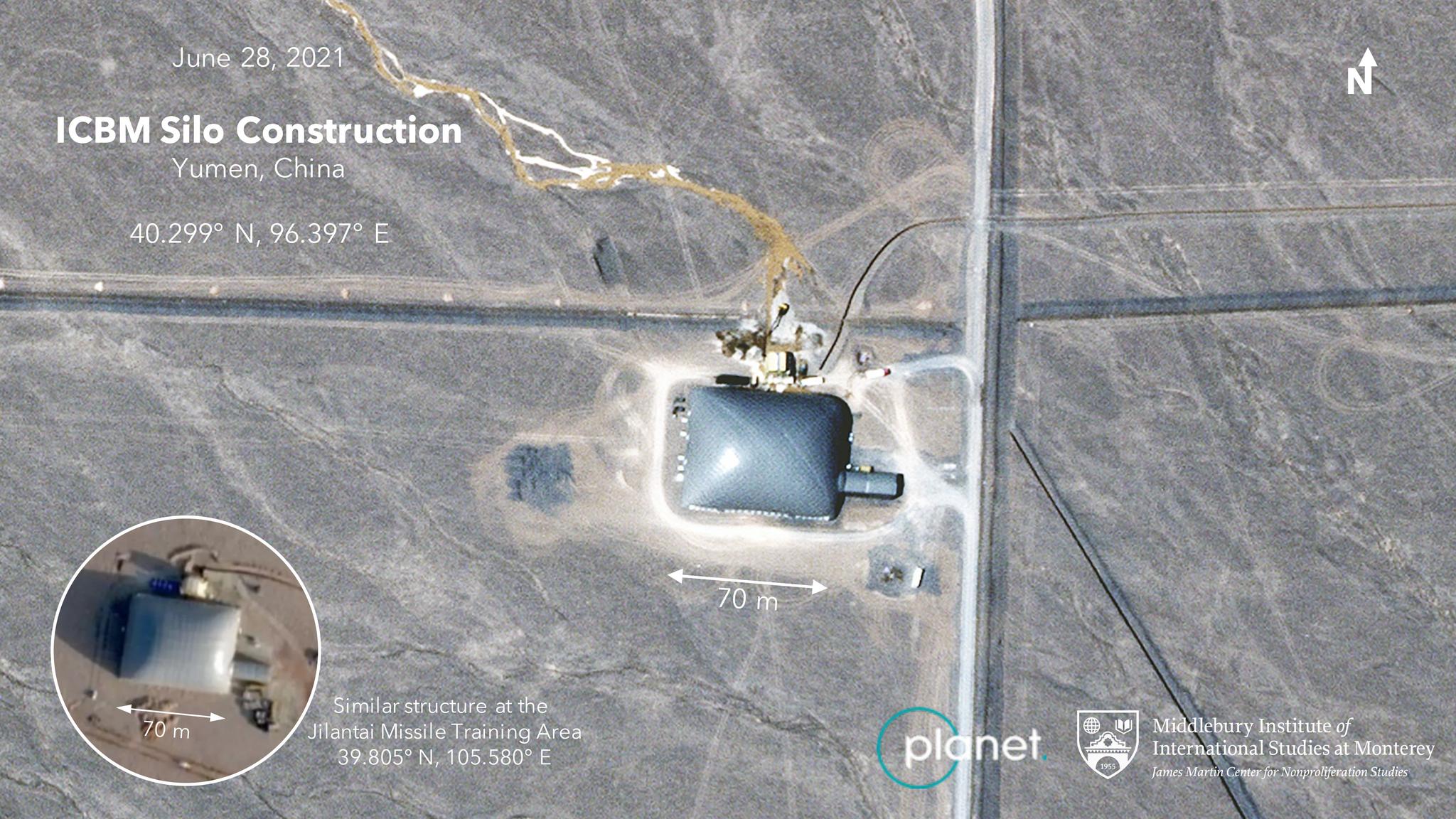
A Planet SkySat image of northwestern China shows what experts say is a construction site for a new silo for a nuclear-tipped ICBM. © 2021, Planet Labs Inc. All Rights Reserved.
StoriesFrom geopolitical tensions to intensifying climate impacts, monitoring Earth’s change has never been more vital. Planet’s satellite data deliver timely and informed insights to journalists around the world to help keep readers informed on global events. Earlier this month, Planet entered into a definitive merger agreement with dMY Technology Group, Inc. IV (NYSE:DMYQ), a special purpose acquisition company, to become a publicly-traded company. Here’s a look at how reporters leveraged Planet satellite imagery to break major stories recently.
GEOPOLITICAL HAPPENINGS
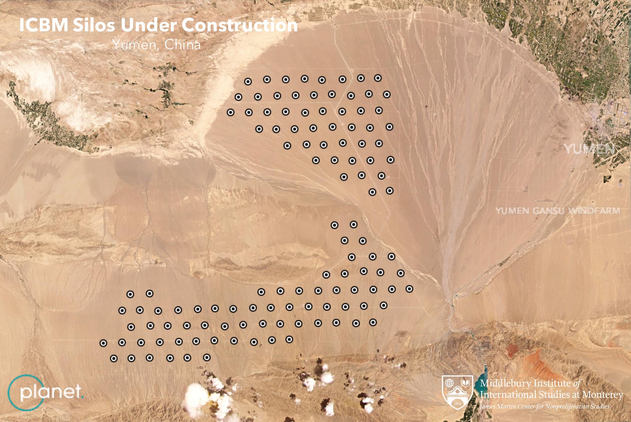
In late June 2021, The Washington Post showcased how researchers from the Middlebury Institute of International Studies (MIIS) used Planet’s satellite imagery to discover the construction of 119 intercontinental ballistic missile (ICBM) silos in China. Experts used Planet’s continuous stream of medium resolution Dove satellite images to monitor progress of the silos’ construction over time. The imagery revealed circular pits, possible control centers, and dome-like structures covering some of the sites, all of which are consistent with other missile silo construction practices. And just yesterday, The New York Times reported that analysts at the Federation of American Scientists (FAS) had discovered a second missile silo field under construction in Eastern Xinjiang, China. This finding, coupled with the MIIS' early analysis, estimates that the country has roughly 230 new missile silos. “The silo construction at Yumen and Hami constitutes the most significant expansion of the Chinese nuclear arsenal ever,” Matt Korda and Hans M. Kristensen wrote. [caption id="attachment_146895" align="aligncenter" width="3367"]
RAPID RESPONSE FOR NATURAL DISASTERS
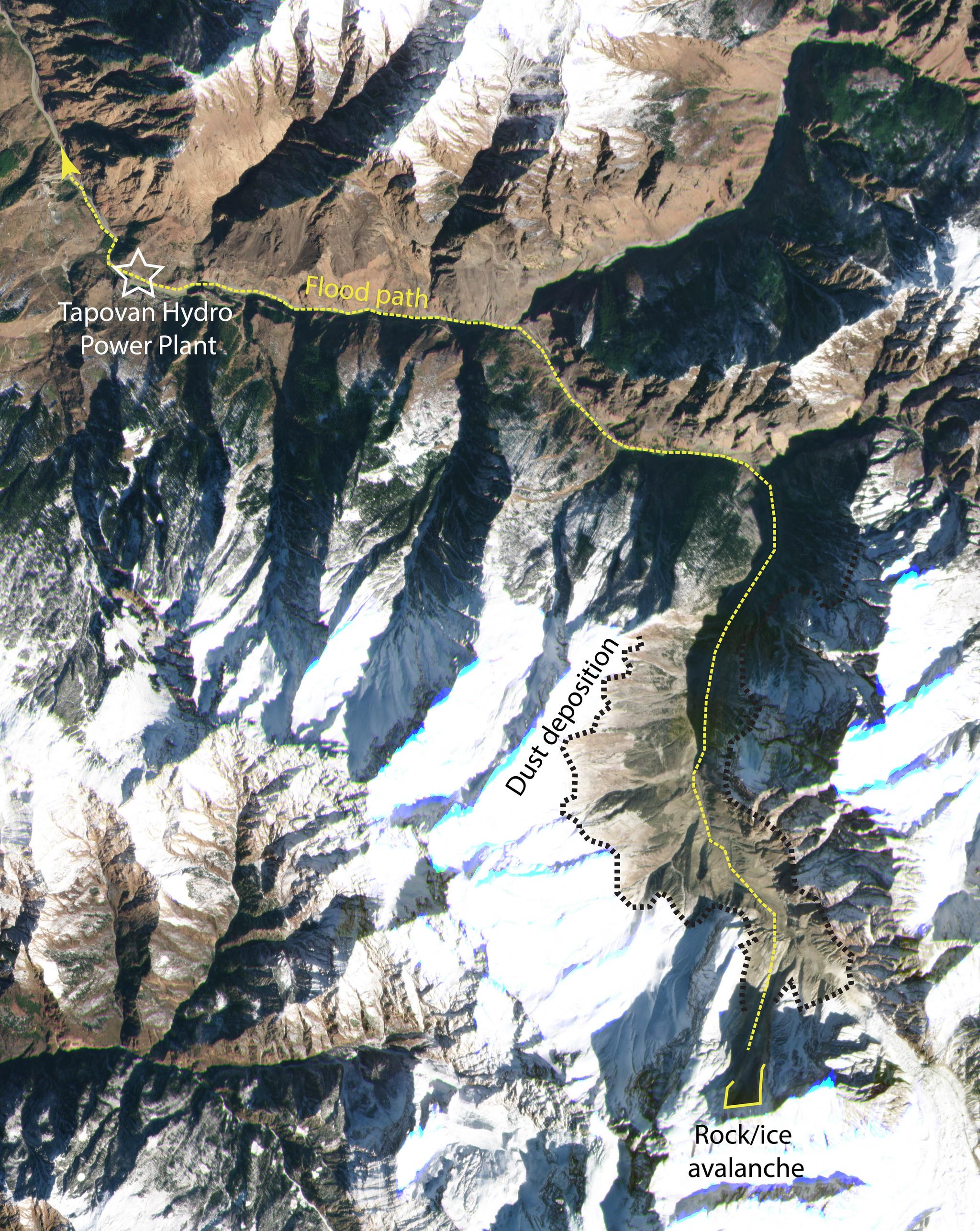
The New York Times: Mountains, Ice and Climate Change: A Recipe for Disasters Planet imagery helped a group of researchers analyze the cause of a devastating landslide that struck the Himalayas on February 7, 2021. The water was originally thought to have come from an outburst of a glacial lake, but Planet’s satellite images from before the disaster showed no evidence of lakes. This led an international team of landslide experts led by Dr. Dan Shugar at the University of Calgary to discover the true cause - a massive rockfall at a location called Ronti Peak. On the day of the landslide, two Planet Dove satellites flew overhead just 27 minutes apart, capturing the dynamics of the landslide in motion. The researchers then used Planet’s SkySat data for a closer look and found dust deposition from the deluge of water, ice, rocks, and debris along the valley from its possible origin high in the mountain to its floor. Their analysis of this event was recently published in Science. [caption id="attachment_146901" align="aligncenter" width="5292"]
HUMANITARIAN CRISIS MONITORING
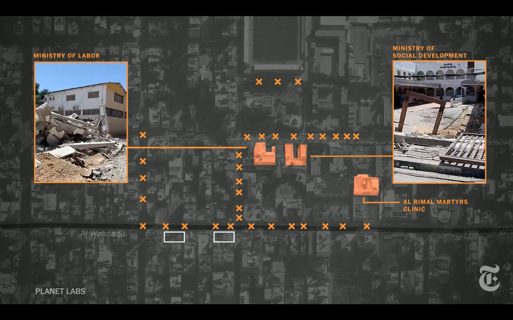
The New York Times: Gaza’s Deadly Night: How Israeli Airstrikes Killed 44 People The New York Times investigated a series of Israeli airstrikes that destroyed three apartment buildings in Gaza and killed 44 people on May 16, 2021. Journalists cross-referenced videos and photos with Planet’s satellite imagery to map out where 20 of the guided bombs launched that night landed in the neighborhood of Rimal in downtown Gaza City. [caption id="attachment_146900" align="aligncenter" width="1600"]
CLIMATE CHANGE WOES
Der Spiegel: Obituary for the Spruce Climate change has arrived among the forests of Thüringer Wald, a mountain range in central Germany. In Obituary for the Spruce, Der Spiegel journalist Barbara Supp and photographer Maurice Weiss visit Thüringer Wald and report on the dire condition of the spruce tree and how the communities who rely on this ecosystem are adapting. Planet satellite imagery shows how drought and an infestation of bark beetles have devastated the number of spruce trees within the forest, represented by the changing forest cover from the summer of 2017 to February 2021. [video mp4="https://storage.googleapis.com/corpeng-pulse-assets/uploads/2021/07/Thuringer_Wald_Thuringia_Germany_Forest_loss_video_1920.mp4"][/video] In other news: KQED used sequences of Planet’s photos that showed diminishing water levels in Lake Mendocino and Lake Sonoma, two of Northern California’s critical reservoirs. Journalists! Planet imagery can be useful for reporters who are investigating important issues. You can sign up for a Planet Explorer account—free for the first two weeks—to unlock the potential for visual and compelling stories.
Ready to Get Started
Connect with a member of our Sales team. We'll help you find the right products and pricing for your needs.