
Navigating the Kakhovka Dam Collapse: NASA Harvest Consortium Assesses Agriculture Impacts with Satellite Imagery
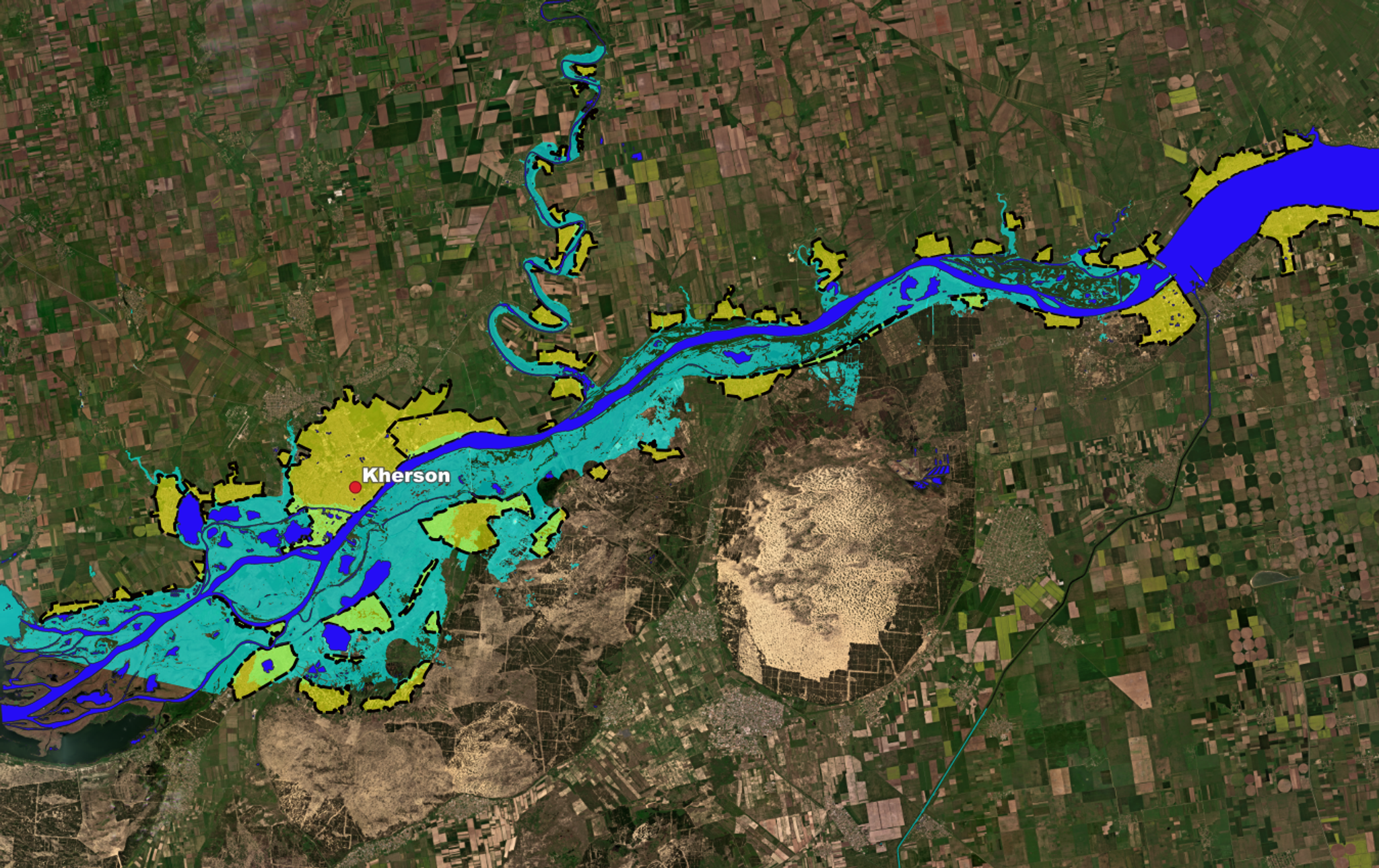
Flooding extent with cities. Yellow denotes cities. Areas in light green are flooded parts of the cities. Dark blue shows water prior to dam collapse, and light blue denotes flooded areas. Credit: NASA Harvest, Sertit iCube, Planet Labs PBC
StoriesOn the heels of the catastrophic destruction of Ukraine’s Kakhovka dam on June 6, recent analysis of satellite imagery by NASA Harvest shows that three of the four major canal inlets vital for farm irrigation are already disconnected, with the fourth dangerously close to joining the list in the coming days. You can read more in the full article below, cross-posted from our partners at NASA Harvest, NASA’s Global Food Security and Agriculture Consortium.
Official government estimates indicate the affected reservoir supplied water to more than 12,000 kilometers of canals. Canal-based irrigation is heavily relied upon in Ukraine in the summer, and the projected summer rains are unlikely to be sufficient to maintain crop health and average yields in the previously-irrigated lands in this part of the country.
NASA Harvest estimates that the total flooded area as of June 7 is around 410-420 square kilometers (or ~103,000 acres) including about 3.5 - 5 square kilometers (or ~1200 acres) of croplands – a number much lower than the initial estimates from the Ministry of Agrarian Policy and Food of Ukraine.
Since the outbreak of the Russo-Ukrainian War in 2022, Planet and NASA Harvest have been tracking the impact of the war on agriculture in Ukraine. Prior reports estimated winter wheat harvests; documented how much of Ukraine’s agriculture was under Russia’s control a few months post-invasion, and a subsequent progress report showed how many winter crops had been harvested and summer/spring crops planted, especially around the frontlines. NASA Harvest continues to update its agricultural assessments this season.
“The combination of real-time satellite imagery and sophisticated analytics have become an indelible tool for anticipating and mitigating the types of risks to our global food systems,” said Planet Chief Impact Officer Andrew Zolli. “The analyses Planet has done with NASA Harvest these past months of Europe’s breadbasket and the scalability that has to other regions experiencing food insecurity can help us to adapt agricultural practices, adjust global supply chains, and mitigate risks to poor and vulnerable communities.”
# # #
Cross-post from NASA Earth Observatory article below:
Navigating The Kakhovka Dam Collapse: NASA Harvest Consortium Assesses Agriculture Impacts With Satellite Imagery
Sun, air, soil, and water - the four key ingredients for healthy crop growth. Disruption of any one of these essential resources, especially without warning, often results in devastating effects for agricultural production. NASA Harvest - NASA’s Global Food Security and Agriculture Consortium, Rapid Response Team - is closely monitoring one such scenario as it plays out in real time. The catastrophic collapse of Ukraine’s Kakhovka dam on June 6 supplies water to large swaths of the Black Sea region’s most productive agricultural lands, and the impacts on crop production and human livelihoods are far-reaching.
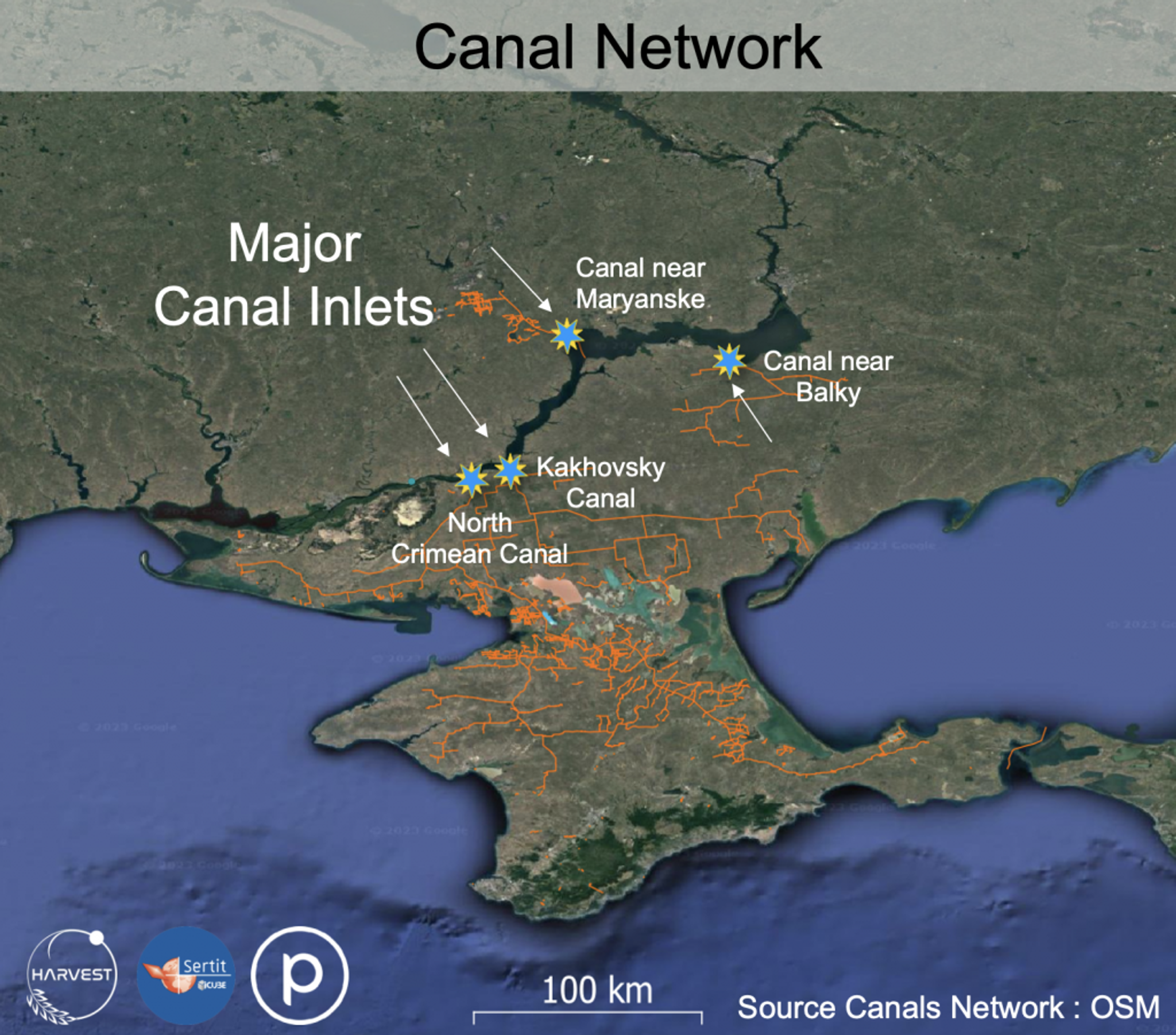
NASA Harvest’s Rapid Action for Agricultural Policy Support (RAAPS) team based at the University of Strasbourg, in partnership with Sertit (University of Strasbourg) used Planet and Sentinel 3 data to monitor the main canal inlets from the Kakhovka Dam that provide water to southern Ukrainian croplands and and to map the flooding extent due to the dam collapse.
In fact, NASA Harvest’s satellite-based analysis shows that three of the four major canal inlets vital for farm irrigation are already disconnected, with the fourth dangerously close to joining the list in the coming days. Canal-based irrigation is heavily relied upon in the summer, and summer rains are unlikely to be sufficient to maintain crop health and average yields in the previously-irrigated lands in this part of Ukraine.
“Prior to the war, Kherson Oblast accounted for over 4% of Ukraine’s gross agricultural production, and the region also encompassed over 6% of wheat production, 8% of soybean and rapeseed production, approximately 13% of vegetable production, and one-third of all melon cultivation . The Kakhovka Reservoir served as the “heart” of an extensive network of irrigation canals that sustained the viability of the region’s agricultural production. The reservoir supplied water to more than 12,000 kilometers of canals, and irrigates more than 500 thousand hectares of croplands in Kherson, Zaporozhye and Dnepropetrovsk regions,” explains Taras Vysotsky, First Deputy Minister of the Ministry of Agrarian Policy and Food of Ukraine.
With the loss of the region’s long-standing irrigation systems served by the reservoir comes threats to summer-planting including corn and sunflower crops and clean drinking water for the surrounding communities. During times of conflict and uncertainty, near-real-time access to damage assessments are often only possible through remotely-sensed satellite imagery given the many challenges and dangers of conducting ground-based assessments.
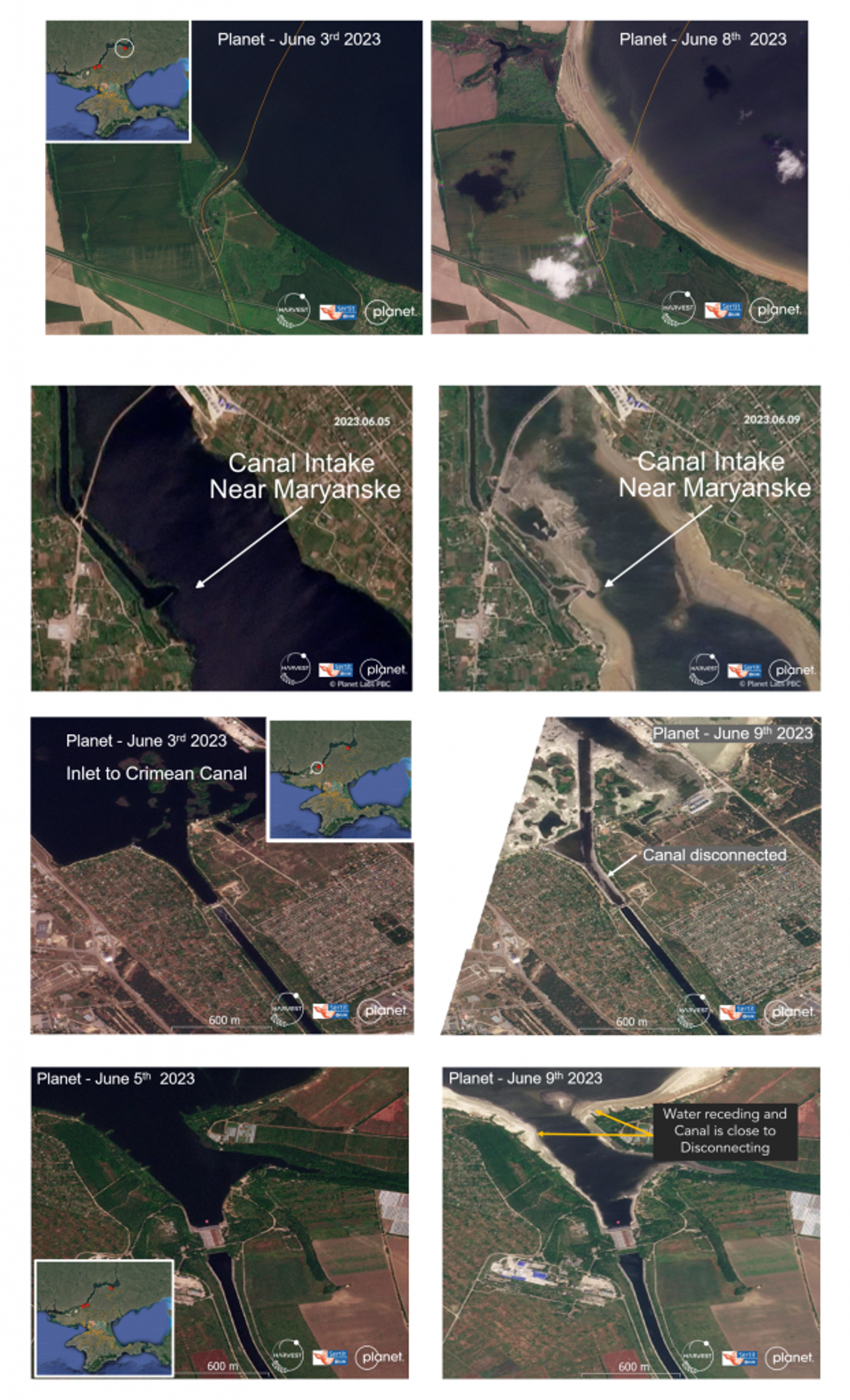
Satellite imagery (source: Planet) showing progressive canal system disconnection from the dam, beginning with: the canal inlet near Maryanske (top) which disconnected from the water supplies on June 9th, northernmost canal near Balky (top) which disconnected from water supplies on June 8th; the Inlet to the North Crimean Canal (middle) which disconnected on June 9th; and the Kakhovsky Canal (bottom) which is expected to disconnect in the coming days.
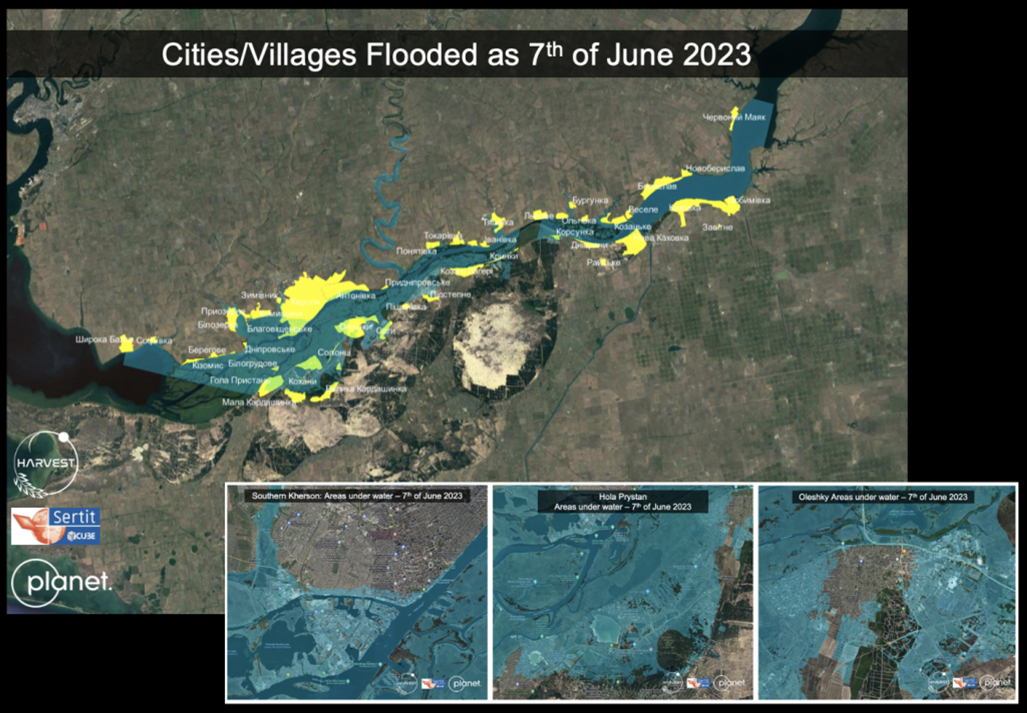
In addition to the loss of vital water supplies for food production and consumption, flooding caused by the dam’s collapse reached surrounding residential areas, with over 20 villages and and cities downstream from the dam seeing over 20 Ha (over 50 acres) of flooding and devastating damage. The socioeconomic impacts of the flooding have yet to be fully realized, and NASA Harvest is continuing to monitor satellite data as flood waters recede.
Communities surrounding the Kakhovka Dam experienced severe flooding, resulting in a still-developing humanitarian and ecological crisis. Earth observation data shows the widespread havoc caused by the dam’s collapse, with yellow areas indicating flooded villages/cities.
Adding to concerns regarding displacement and inhumane conditions for local residents, one of the top concerns for global officials and economists is the food security implications and market volatility resulting from the damage to these croplands primarily due to loss of irrigation. NASA Harvest estimates that the total flooded area as of June 7, 2023 is around 410-420 square kilometers (or ~103,000 acres) including about 3.5 - 5 square kilometers (or ~1200 acres) of croplands. NASA Harvest’s estimates of flooded croplands are much lower than initial numbers that were released by other estimates.
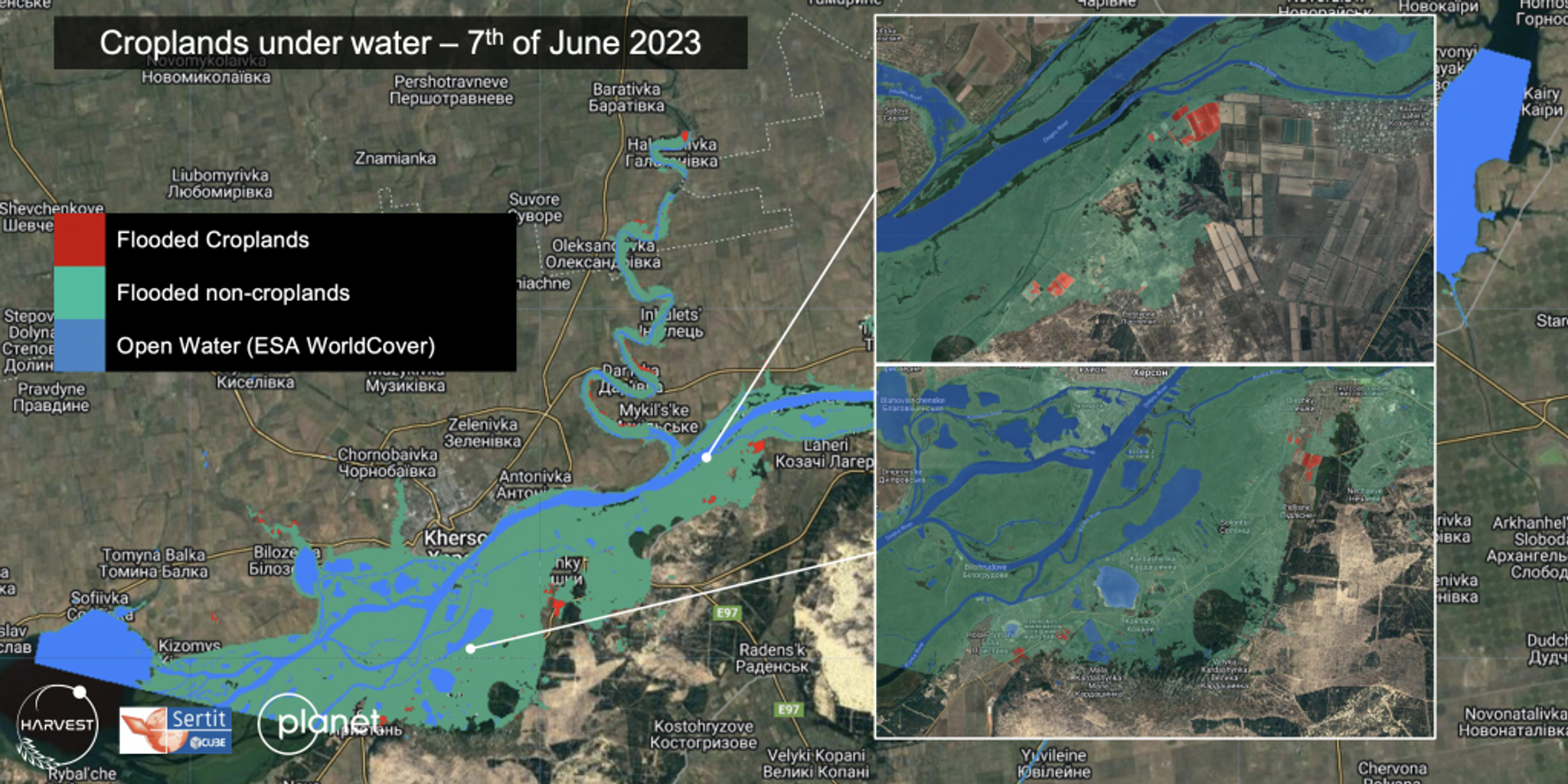
In partnership with Planet and SERTIT, NASA Harvest was able to produce a comprehensive map of flooded croplands, flooded villages, and open water, providing critical information for the Ukrainian Ministry of Agriculture and humanitarian response.
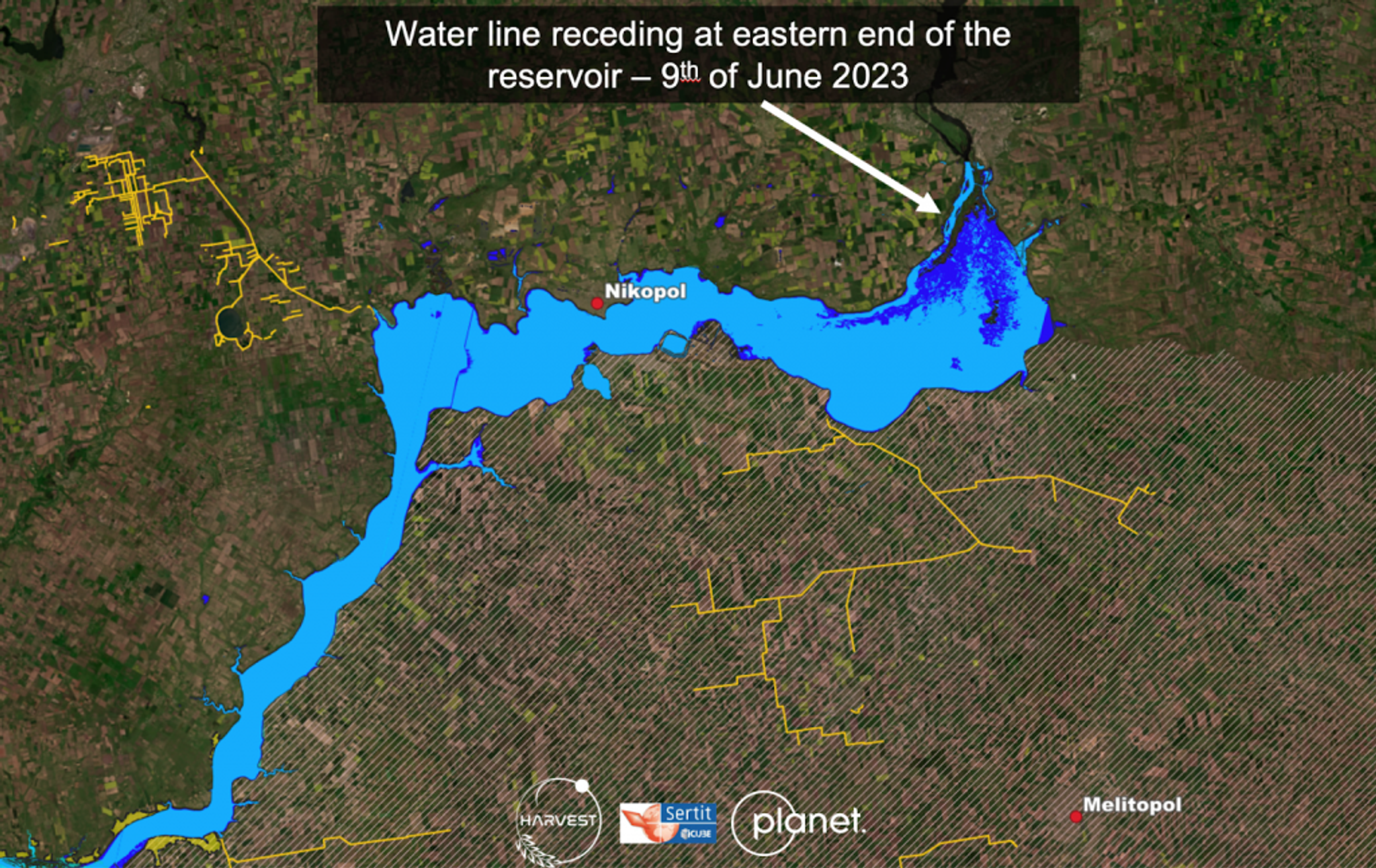
As of June 9th, 2023 satellite imagery shows flood waters receding from the northeast regions of Ukraine.
As Harvest Director Dr. Inbal Becker-Reshef notes, “it is essential that policy makers have up-to-date information in order to prepare global and national food systems effectively, and to efficiently respond to dynamic environmental conditions and disasters. Currently, there is not a trusted and widely used framework that interconnects real-time data on our global food system production with geography-specific, rapid agricultural assessments in response to specific events that impact agricultural production and distribution.” Going forward, NASA Harvest partners continue to use Earth observation-based data to inform rapid responses to unanticipated events that shock the global food system and threaten food security. “NASA Harvest is committed to continuing to support the Ukrainian government and to work closely with our partners to provide reliable, timely data in support of critical agricultural and food security decisions in Ukraine”.
Ready to Get Started
Connect with a member of our Sales team. We'll help you find the right products and pricing for your needs.