
Planet’s Data Helps Amnesty International Tackle Deforestation In Cambodia
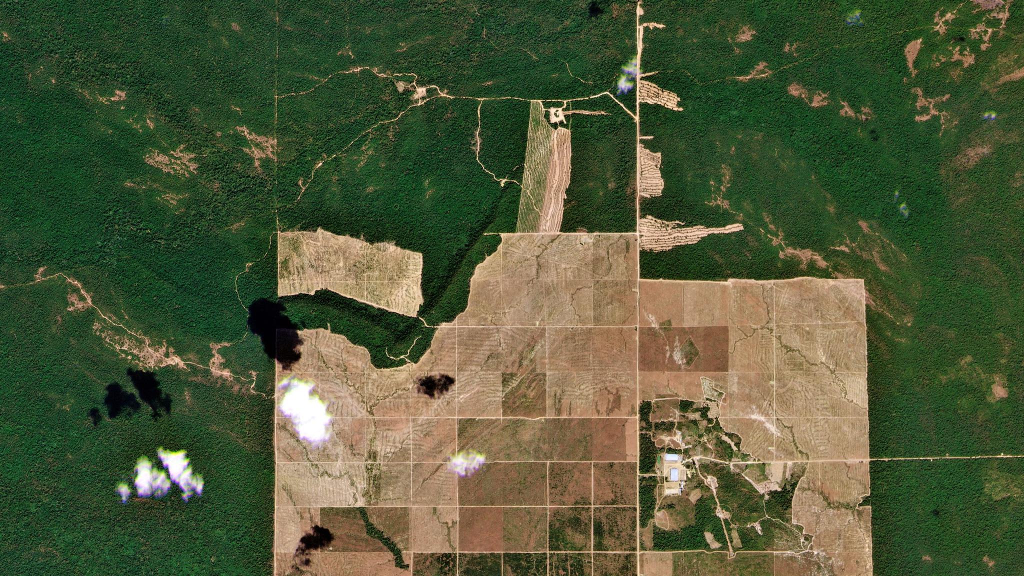
PlanetScope image of logging along the eastern boundary of the Prey Lang Wildlife Sanctuary in Cambodia on January 10, 2022. © 2022, Planet Labs PBC. All Rights Reserved.
StoriesGraphics by Leanne Abraham, analysis and annotations by Amnesty International.
In the ancient forests of Cambodia, Amnesty International relies on Planet's daily monitoring to help fulfill its mission of ending human rights abuses worldwide. Our satellite data, along with a "tip and cue" strategy, help Amnesty International identify and shed light on environmental abuses to slow or stop them before they irreversibly harm people and the ecosystem.
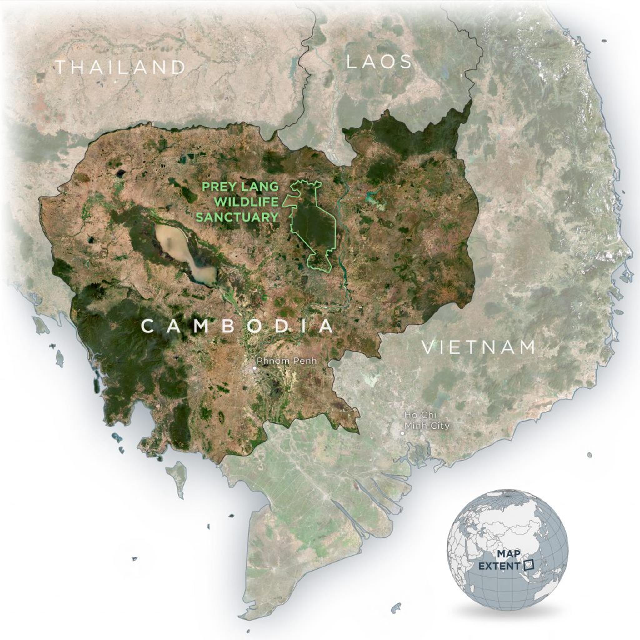
Map showing the location of the Prey Lang Wildlife Sanctuary in Cambodia (Data Sources: Planet monthly mosaic, Natural Earth, Open Development Cambodia)
Prey Lang Wildlife Sanctuary is southeast Asia's largest lowland evergreen forest. The sanctuary spans approximately 500,000 hectares across four provinces of Cambodia. Designated as a wildlife sanctuary in 2016, Prey Lang is government-protected land, containing diverse flora and fauna. This land plays a vital role in the traditions, local customs, and beliefs of indigenous people and local communities. Yet, recent events have weakened the sanctuary's natural defenses and degraded its borders. The sale of timber rights on land just outside the sanctuary's eastern border has negatively impacted Prey Lang.
Amnesty International began monitoring illegal logging in Prey Lang, and Micah Farfour, a Special Advisor in Remote Sensing for their Crisis Response Program, has a long history of working with GIS and satellite imagery to monitor change globally. She and her team have effectively used Planet's satellite data to identify and track illegal activity within the sanctuary's borders.
After the government sold the timber rights to the land bordering Prey Lang, the winning company actively and legally clear-cut and harvested its concession, but with unintended consequences for Prey Lang. The disappearance of trees bordering the sanctuary eased access for people and vehicles. Easier access and high timber prices for certain tree species contributed to the illegal logging of the sanctuary's old resin and other trees.
Given the vast size of the sanctuary, monitoring the area is difficult for Farfour and her team. The high level of cloud coverage over the region hinders remote sensing. And degradation happens at the individual tree level, which requires a high level of detail for effective monitoring.
Every year, Farfour’s team assesses an annual dataset of Cambodia’s forests to see the deforestation of the past. Although valuable, this data, Farfour says, "is not stopping trees from being cut. It's just showing that the tree has been cut and obviously getting ahead of the problem is our goal."
To counter these challenges, Amnesty International has adopted Planet's satellite imagery. Using our data, Amnesty can now identify and address areas of rapid deforestation within the sanctuary in real-time and work to prevent further harm.
Our satellite images help Farfour's team monitor Prey Lang Wildlife Sanctuary for environmental abuse by remotely monitoring, capturing, and inspecting the entire sanctuary expanse using our PlanetScope constellation. Along with this data, Farfour effectively employs a “tip and cue” strategy, which uses medium resolution, high-frequency PlanetScope images to identify areas of concern in order to task a high-resolution SkySat satellite for more detail.
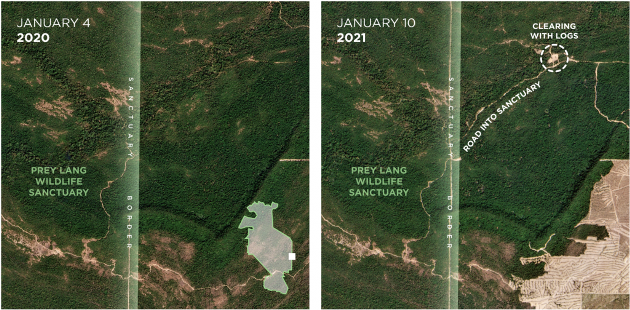
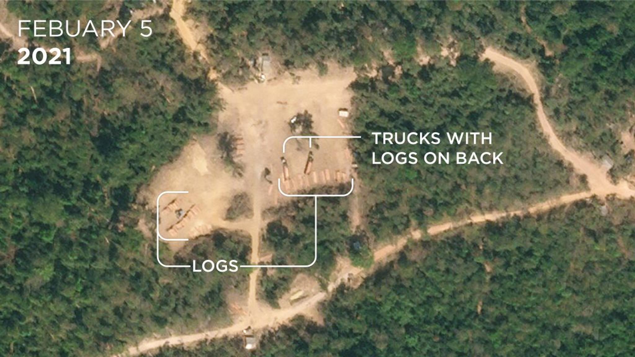
New road construction leading into the Prey Lang Wildlife Sanctuary captured in PlanetScope imagery between January 2020 and January 2021. Planet SkySat on February 5, 2021 then captured high resolution imagery of the new clearing, showing piles of logs and loaded trucks. While this clearing is outside of the sanctuary, some of the tracks from this clearing lead directly into Prey Lang. Annotations courtesy of Amnesty International.
Amnesty relies on PlanetScope data to monitor Prey Lang. Image details are scrutinized, and Farfour's team is alerted to potential areas of deforestation. The daily frequency improves the chances of getting a cloud-free picture. Spatial resolution of approximately 3 meters per pixel can quickly pick up deforestation over a large area. From there, a high-resolution SkySat is then tasked to focus on those targeted areas for a closer look at the forest, individual trees, and even machinery.
Farfour shares, "High-resolution imagery is actually quite rare over these wildlife sanctuaries in Cambodia, so we've had to be resourceful with the lower resolution imagery and develop areas of interest to task with high resolution since the protected areas are very large."
In addition to deforestation, Planet data helps detect land clearing for road development or agriculture. For example, Farfour used our satellite imagery to identify a new road on the other side of the sanctuary's eastern boundary. She says, "a lot of the access comes from the edges, the boundaries, where there are roads already established, but sometimes potentially from the villages. The new road not only increased access to the area, it provided an easy route for the illegal logging and transport of timber outside of the sanctuary."
Today, we are working with Amnesty to refine the data analysis even further. Farfour comments, "We're doing things like testing radar imagery to be able to detect through cloud cover and testing road detection algorithms with Planet." As these capabilities expand, satellite images will help Farfour and her team better protect Prey Lang on the ground.
This critical work with Amnesty provides a blueprint for greater transparency and better monitoring of potential illegal activities. Many civil governments and NGOs can benefit from Planet satellite imagery and a "tip and cue" strategy to monitor environmental damage. Our data helps organizations form an objective picture and build greater transparency to move beyond monitoring and to move beyond responsive monitoring to results-driven advocacy.
To learn more about our work with Amnesty International, view our case study.
Ready to Get Started
Connect with a member of our Sales team. We'll help you find the right products and pricing for your needs.