San Francisco, October 22, 2015

Tagged by: aerospace

From Drones to PlanetScope, Mapping Meddlesome Roses

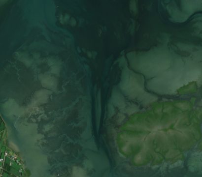
Image above: PlanetScope image of invasive rose study site along the coastline of Vainupea, Estonia taken August 28, 2022. © 2022, Planet Labs PBC. All Rights Reserved. Many are captivated by what is arguably the world’s most romantic flower, the rose, symbol of love and admiration, but sometimes these flowers of passion […]

Scientists combine both x-ray techniques and satellite data for environmental forensics

Image above: PlanetScope image of Alto Araguaia, Brazil taken November 25, 2022. © 2022, Planet Labs PBC. All Rights Reserved. Soybean production in Brazil has significantly increased over the last twenty years as a result of national and international demand. Following harvest, trucks and trains transport this popular crop to designated shipment […]

PlanetScope Helps Monitor Bull Kelp Communities on California Coastline

Paper

Above image: Bull kelp habitat off the coast of California taken April 10, 2023. © 2023, Planet Labs PBC. All Rights Reserved. Ecosystems are full of complex and interacting elements, both biotic and abiotic. But when several of these elements begin to change at the same time, scientists have witnessed a dramatic […]

Observing Mixed Cover Crops from Space

Paper

Image above: PlanetScope image of crop biomass estimation site in Washington County, Mississippi taken April 9, 2022. © 2022, Planet Labs PBC. All Rights Reserved. In agricultural fields, cover crops are planted at certain times of the year to cover up the farming soil. These plants are not set to be harvested […]

Ice-dam Failures Revealed with PlanetScope Data

Image above: PlanetScope image of ice-dam study site in Jokulsarlon, Iceland taken March 2, 2023. © 2023, Planet Labs PBC. All Rights Reserved. In icy environments, mountain lakes can be dammed not by just rock, but by long standing ice formations. But with the ongoing retreat of glaciers and icecaps around the […]

Monitoring Mass Flowering Events from Space

Paper

Image above: White flowering tree crowns spot the dense green forest in Lambir Hills National Park in Borneo, Malaysia on May 5, 2019. © 2019, Planet Labs PBC. All Rights Reserved. In the dense tropical forests of Southeast Asia, scientists are monitoring the phenomenon of “general flowering” which is the synchronous mass […]

Satellite Data Helps Reveal Impacts of Hydroelectric Dams on Local Ecosystems

Paper

Image above: Flooding in Brazilian Amazon study site following hydroelectric complex installation taken June 28, 2022. © 2022, Planet Labs PBC. All Rights Reserved. In Brazil, approximately 60% of the country’s electricity is powered by hydro dams. However, since the 1990s, there has been pressure on the country’s environment because of the […]

Understanding Landslide Risk with Planet Imagery

Paper

Image above: Planet image of a landslide in the Hurunui district of Canterbury in the South Island of New Zealand taken March 22, 2019. © 2019, Planet Labs PBC. All Rights Reserved. In mountainous regions around the world, landslides cause significant harm to lives and economies. Between 1990 and 2017, these disasters […]

Mapping climate risk in urban settlements with PlanetScope and Google Earth Engine

Paper

Image above: PlanetScope image of Durban, South Africa taken January 9, 2023. © 2023, Planet Labs PBC. All Rights Reserved. In the United Nations’ 2030 Sustainable Development Goals, the improvement of informal settlements was listed as a priority. Informal settlements can be characterized as urban developments with densely packed housing typically made […]

Our websites use cookies.
We use cookies to improve our services and tailor content for you. Your browser settings control cookies. For more information about the use of cookies on our websites, please see our Privacy Policy.