
Satellite Data on the Go: Planet and the onX suite of apps Enable Your Outdoor Adventures
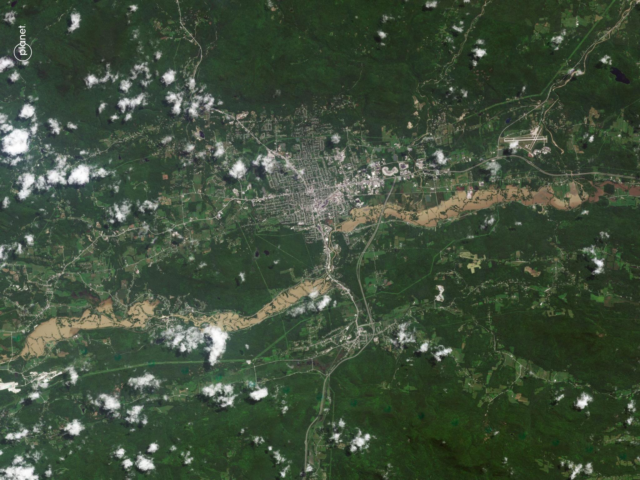
PlanetScope image of flooding of Otter Creek in Rutland, Vermont taken July 11, 2023. © 2023 Planet Labs PBC. All Rights Reserved.
NewsAcross the United States, outdoor enthusiasts are packing their backpacks, lacing up their shoes, and filling their water bottles for long, nature-filled weekends. As summer moves into fall, they are trading in their baseball caps for their wool flannel shirts, and checking their weather app in the process. These recreationists are also swiping through their phones and preparing for their trips with onX’s suite of recreation apps which deliver detailed geospatial information about wilderness adventure sites across the entire nation.
“We want to awaken and empower adventure in everybody,” said Brian Riordan, Sr. Director of Geospatial at onX. He emphasized that the company is focused on providing a navigation discovery tool that enables outdoor enthusiasts to explore with confidence, make safe decisions, and support land stewardship.
And now, onX users also have Planet data at their fingertips.
For adventurers, this type of information can be critical, especially because our wild landscapes are constantly in flux. Prior to working with Planet, onX recognized that they needed timely environmental data for their customers. From seasonal shifts to natural disasters, onX knew that to help individuals take a step into the wild unknown, they needed to provide them with high-cadence satellite imagery. Riordan explained that while they had integrated satellite data into their apps, sometimes the default image was up to four years old. Using satellite imagery to check the recent snow line or avoid new flooding damage wasn’t exactly an option. But now, with the launch of their Recent Imagery app feature, onX is providing their users with new satellite imagery in the form of Planet imagery on a bi-weekly basis.
“Working with Planet has been fantastic,” said Riordan. “Planet’s monthly satellite imagery offering was too far apart for our customers’ needs. So we worked with the technical team to create a two-week mosaic solution that leverages daily insights, stitching together 14 days of imagery into one.
This 14-day frequency enables onX’s users to leverage Planet’s imagery to plan and schedule their adventure trips for everything, from hiking and skiing to game hunting and rock climbing. “Outdoor recreation continues to fluctuate immensely between weather and seasonality,” said Riordan. “If somebody's going out, understanding if a leaf bud burst happened in the location can tell you so much about what's actually happening on the ground there, from mosquitoes, black flies, snow lines, and ice coverage. If you're trying to actually go skiing in the backcountry, and there's no snow, that's a really important thing to know.”
onX drapes the Planet mosaics over their 2D and 3D digital elevation models to help their users pan and zoom around these recreation sites to check on their intended recreation area. Riordan gave his own anecdote, “You can zoom around a mountain and say, ‘Oh, now I see the southern slope of the mountain and how much more snow melt is over there versus the northern side. What does that mean for me?’ For example, I was in Moab a couple of months ago, and I was all excited because I was going to ride my mountain bike. I asked, ‘Wow, what's going on up there?’ I had access to Planet data and I looked at it. There was still about 10 feet of snow. I then knew it was worthless to go up there to bike.”
onX also looks to leverage our data to build awareness of environmental impacts and support safe decision making. “This can include avoiding potentially muddy trails to prevent trail erosion and encouraging people to head out only when it's safe to do so, which can avoid putting pressure on local land management search and rescue efforts. We can see this up in Vermont with the local flooding that we've had over the past summer. Trails and roads were washed out, and being able to see these roads and how much impact they have can help our users stay away from them,” Riordan explained.
With Planet imagery, onX provides data on every single state in the United States. “There was this evolution in this new opportunity for Planet and for us,” said Riordan. “We could say, ‘Hey, we're not looking to just monitor one county over and over again, we're looking to understand on a much broader scale, what's happening across the U.S. because that's our customer base. This is our large, really invested, really dynamic group of individuals.” Someone living in Indiana can plan a recreational trip to Colorado and also dream up an adventure in Alaska, he explained.
By combining our two-week satellite data mosaics with their own additional geospatial data, including information on private and public land designations, onX also aims to help their nature-loving users engage in responsible recreation and stewardship practices, so that these outdoor opportunities are around for generations to come.
“You'll hear the safety and this land stewardship theme over and over again when anybody talks about onX. It's really anchored in our internal DNA as a company, which is where this Planet relationship really begins to grow. Because safety, imagery, monitoring, climate – all this comes together into these really powerful moments that our customers love to see.”
Ready to Get Started
Connect with a member of our Sales team. We'll help you find the right products and pricing for your needs.