Planet Pulse

Seeing Crop Activity Across Fields, Every Season

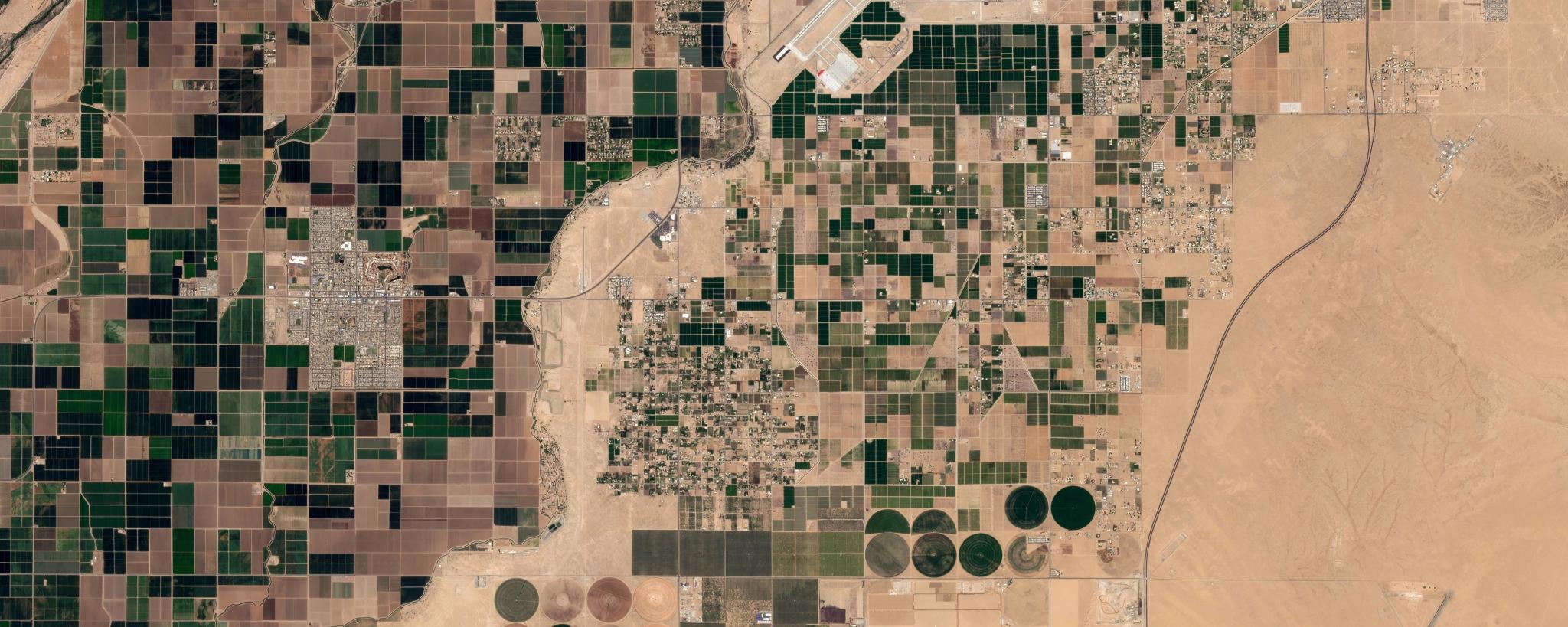
PlanetScope image of agricultural area around Yuma, Arizona captured April, 2026. © Planet Labs 2026. All rights reserved.​​​​‌‍​‍​‍‌‍‌​‍‌‍‍‌‌‍‌‌‍‍‌‌‍‍​‍​‍​‍‍​‍​‍‌​‌‍​‌‌‍‍‌‍‍‌‌‌​‌‍‌​‍‍‌‍‍‌‌‍​‍​‍​‍​​‍​‍‌‍‍​‌​‍‌‍‌‌‌‍‌‍​‍​‍​‍‍​‍​‍​‍‌​‌‌​‌‌‌‌‍‌​‌‍‍‌‌‍​‍‌‍‍‌‌‍‍‌‌​‌‍‌‌‌‍‍‌‌​​‍‌‍‌‌‌‍‌​‌‍‍‌‌‌​​‍‌‍‌‌‍‌‍‌​‌‍‌‌​‌‌​​‌​‍‌‍‌‌‌​‌‍‌‌‌‍‍‌‌​‌‍​‌‌‌​‌‍‍‌‌‍‌‍‍​‍‌‍‍‌‌‍‌​​‌‌‍‌‍​‍‌‌‍​‍‌‍‌​‌‍​‌​​‍​‌​​​‍​‍‌​​‌​‌​‌​​​‍‌​‌​‌‍​‌​‌‍​‍​​‍‌​‍​​​​‌‍​‌​​​‍‌​‍​‌‍​​​‌​‍‌​‌‌‌‍‌‌​​​​‍‌​‌​​​​​​‌‍​‌​‍‌‌​‌‍‌‌​​‌‍‌‌​‌‌​​‌‍‌​‌‌​​‍‌​​‌‍​‌‌‌​‌‍‍​​‌‌‍‌‌‍​‌‌‍‍‌‌‍‍‌​‍‌‌‍‌‌‍​‌‌‍‌‌‍‌‌​‍‍‌‍​‌‌‍​‌‌​​‌‍​‍‌‍​‌‌​‌‍‌‌‌‌‌‌‌​‍‌‍​​‌​‍‌‌​​‍‌​‌‍‌​‌‌​‌‌‌‌‍‌​‌‍‍‌‌‍​‍‌‍‌‍‍‌‌‍‌​​‌‌‍‌‍​‍‌‌‍​‍‌‍‌​‌‍​‌​​‍​‌​​​‍​‍‌​​‌​‌​‌​​​‍‌​‌​‌‍​‌​‌‍​‍​​‍‌​‍​​​​‌‍​‌​​​‍‌​‍​‌‍​​​‌​‍‌​‌‌‌‍‌‌​​​​‍‌​‌​​​​​​‌‍​‌​‍‌‍‌‌​‌‍‌‌​​‌‍‌‌​‌‌​​‌‍‌​‌‌​​‍‌‍‌​​‌‍​‌‌‌​‌‍‍​​‌‌‍‌‌‍​‌‌‍‍‌‌‍‍‌​‍‌‌‍‌‌‍​‌‌‍‌‌‍‌‌​‍‍‌‍​‌‌‍​‌‌​​‍‌‍‌​​‌‍‌‌‌​‍‌​‌​​‌‍‌‌‌‍​‌‌​‌‍‍‌‌‌‍‌‍‌‌​‌‌​​‌‌‌‌‍​‍‌‍​‌‍‍‌‌​‌‍‍​‌‍‌‌‌‍‌​​‍​‍‌‌​​​​‌‍​‍​‍‌‍‌​‍‌‍‍‌‌‍‌‌‍‍‌‌‍‍​‍​‍​‍‍​‍​‍‌​‌‍​‌‌‍‍‌‍‍‌‌‌​‌‍‌​‍‍‌‍‍‌‌‍​‍​‍​‍​​‍​‍‌‍‍​‌​‍‌‍‌‌‌‍‌‍​‍​‍​‍‍​‍​‍​‍‌​‌‌​‌‌‌‌‍‌​‌‍‍‌‌‍​‍‌‍‍‌‌‍‍‌‌​‌‍‌‌‌‍‍‌‌​​‍‌‍‌‌‌‍‌​‌‍‍‌‌‌​​‍‌‍‌‌‍‌‍‌​‌‍‌‌​‌‌​​‌​‍‌‍‌‌‌​‌‍‌‌‌‍‍‌‌​‌‍​‌‌‌​‌‍‍‌‌‍‌‍‍​‍‌‍‍‌‌‍‌​​‌‌‍​‌‌‍​‍‌‍‌‌​‍‌​‌‌‍​‌​​‌‌‍​‍​‍‌​​​‌​​‌‍‌‌​‍‌​‌​​​‍​‍​‌‍​‍​‍‌‌‍​‍​‍​​‌‌‍​‌​‍‌‌‍​‍​​‌​‌‍​‌​​‍​​‍‌‌‍‌‌​​​​​​‌‍​‌‌‍​‍‌‍‌​​‍‌‌​‌‍‌‌​​‌‍‌‌​‌‌​​‌‍‌​‌‌​​‍‌​​‌‍​‌‌‌​‌‍‍​​‌‌‍‌‌‍​‌‌‍‍‌‌‍‍‌​‍‌‌‍‌‌‍​‌‌‍‌‌‍‌‌​‍‍‌‍​‌‌‍​‌‌​​‌‍​‍‌‍​‌‌​‌‍‌‌‌‌‌‌‌​‍‌‍​​‌​‍‌‌​​‍‌​‌‍‌​‌‌​‌‌‌‌‍‌​‌‍‍‌‌‍​‍‌‍‌‍‍‌‌‍‌​​‌‌‍​‌‌‍​‍‌‍‌‌​‍‌​‌‌‍​‌​​‌‌‍​‍​‍‌​​​‌​​‌‍‌‌​‍‌​‌​​​‍​‍​‌‍​‍​‍‌‌‍​‍​‍​​‌‌‍​‌​‍‌‌‍​‍​​‌​‌‍​‌​​‍​​‍‌‌‍‌‌​​​​​​‌‍​‌‌‍​‍‌‍‌​​‍‌‍‌‌​‌‍‌‌​​‌‍‌‌​‌‌​​‌‍‌​‌‌​​‍‌‍‌​​‌‍​‌‌‌​‌‍‍​​‌‌‍‌‌‍​‌‌‍‍‌‌‍‍‌​‍‌‌‍‌‌‍​‌‌‍‌‌‍‌‌​‍‍‌‍​‌‌‍​‌‌​​‍‌‍‌​​‌‍‌‌‌​‍‌​‌​​‌‍‌‌‌‍​‌‌​‌‍‍‌‌‌‍‌‍‌‌​‌‌​​‌‌‌‌‍​‍‌‍​‌‍‍‌‌​‌‍‍​‌‍‌‌‌‍‌​​‍​‍‌‌

PlanetScope image of agricultural area around Yuma, Arizona captured April, 2026. © Planet Labs 2026. All rights reserved.​​​​‌‍​‍​‍‌‍‌​‍‌‍‍‌‌‍‌‌‍‍‌‌‍‍​‍​‍​‍‍​‍​‍‌​‌‍​‌‌‍‍‌‍‍‌‌‌​‌‍‌​‍‍‌‍‍‌‌‍​‍​‍​‍​​‍​‍‌‍‍​‌​‍‌‍‌‌‌‍‌‍​‍​‍​‍‍​‍​‍​‍‌​‌‌​‌‌‌‌‍‌​‌‍‍‌‌‍​‍‌‍‍‌‌‍‍‌‌​‌‍‌‌‌‍‍‌‌​​‍‌‍‌‌‌‍‌​‌‍‍‌‌‌​​‍‌‍‌‌‍‌‍‌​‌‍‌‌​‌‌​​‌​‍‌‍‌‌‌​‌‍‌‌‌‍‍‌‌​‌‍​‌‌‌​‌‍‍‌‌‍‌‍‍​‍‌‍‍‌‌‍‌​​‌‌‍‌‍​‍‌‌‍​‍‌‍‌​‌‍​‌​​‍​‌​​​‍​‍‌​​‌​‌​‌​​​‍‌​‌​‌‍​‌​‌‍​‍​​‍‌​‍​​​​‌‍​‌​​​‍‌​‍​‌‍​​​‌​‍‌​‌‌‌‍‌‌​​​​‍‌​‌​​​​​​‌‍​‌​‍‌‌​‌‍‌‌​​‌‍‌‌​‌‌​​‌‍‌​‌‌​​‍‌​​‌‍​‌‌‌​‌‍‍​​‌‌‍‌‌‍​‌‌‍‍‌‌‍‍‌​‍‌‌‍‌‌‍​‌‌‍‌‌‍‌‌​‍‍‌‍​‌‌‍​‌‌​​‌‍​‍‌‍​‌‌​‌‍‌‌‌‌‌‌‌​‍‌‍​​‌​‍‌‌​​‍‌​‌‍‌​‌‌​‌‌‌‌‍‌​‌‍‍‌‌‍​‍‌‍‌‍‍‌‌‍‌​​‌‌‍‌‍​‍‌‌‍​‍‌‍‌​‌‍​‌​​‍​‌​​​‍​‍‌​​‌​‌​‌​​​‍‌​‌​‌‍​‌​‌‍​‍​​‍‌​‍​​​​‌‍​‌​​​‍‌​‍​‌‍​​​‌​‍‌​‌‌‌‍‌‌​​​​‍‌​‌​​​​​​‌‍​‌​‍‌‍‌‌​‌‍‌‌​​‌‍‌‌​‌‌​​‌‍‌​‌‌​​‍‌‍‌​​‌‍​‌‌‌​‌‍‍​​‌‌‍‌‌‍​‌‌‍‍‌‌‍‍‌​‍‌‌‍‌‌‍​‌‌‍‌‌‍‌‌​‍‍‌‍​‌‌‍​‌‌​​‍‌‍‌​​‌‍‌‌‌​‍‌​‌​​‌‍‌‌‌‍​‌‌​‌‍‍‌‌‌‍‌‍‌‌​‌‌​​‌‌‌‌‍​‍‌‍​‌‍‍‌‌​‌‍‍​‌‍‌‌‌‍‌​​‍​‍‌‌​​​​‌‍​‍​‍‌‍‌​‍‌‍‍‌‌‍‌‌‍‍‌‌‍‍​‍​‍​‍‍​‍​‍‌​‌‍​‌‌‍‍‌‍‍‌‌‌​‌‍‌​‍‍‌‍‍‌‌‍​‍​‍​‍​​‍​‍‌‍‍​‌​‍‌‍‌‌‌‍‌‍​‍​‍​‍‍​‍​‍​‍‌​‌‌​‌‌‌‌‍‌​‌‍‍‌‌‍​‍‌‍‍‌‌‍‍‌‌​‌‍‌‌‌‍‍‌‌​​‍‌‍‌‌‌‍‌​‌‍‍‌‌‌​​‍‌‍‌‌‍‌‍‌​‌‍‌‌​‌‌​​‌​‍‌‍‌‌‌​‌‍‌‌‌‍‍‌‌​‌‍​‌‌‌​‌‍‍‌‌‍‌‍‍​‍‌‍‍‌‌‍‌​​‌‌‍​‌‌‍​‍‌‍‌‌​‍‌​‌‌‍​‌​​‌‌‍​‍​‍‌​​​‌​​‌‍‌‌​‍‌​‌​​​‍​‍​‌‍​‍​‍‌‌‍​‍​‍​​‌‌‍​‌​‍‌‌‍​‍​​‌​‌‍​‌​​‍​​‍‌‌‍‌‌​​​​​​‌‍​‌‌‍​‍‌‍‌​​‍‌‌​‌‍‌‌​​‌‍‌‌​‌‌​​‌‍‌​‌‌​​‍‌​​‌‍​‌‌‌​‌‍‍​​‌‌‍‌‌‍​‌‌‍‍‌‌‍‍‌​‍‌‌‍‌‌‍​‌‌‍‌‌‍‌‌​‍‍‌‍​‌‌‍​‌‌​​‌‍​‍‌‍​‌‌​‌‍‌‌‌‌‌‌‌​‍‌‍​​‌​‍‌‌​​‍‌​‌‍‌​‌‌​‌‌‌‌‍‌​‌‍‍‌‌‍​‍‌‍‌‍‍‌‌‍‌​​‌‌‍​‌‌‍​‍‌‍‌‌​‍‌​‌‌‍​‌​​‌‌‍​‍​‍‌​​​‌​​‌‍‌‌​‍‌​‌​​​‍​‍​‌‍​‍​‍‌‌‍​‍​‍​​‌‌‍​‌​‍‌‌‍​‍​​‌​‌‍​‌​​‍​​‍‌‌‍‌‌​​​​​​‌‍​‌‌‍​‍‌‍‌​​‍‌‍‌‌​‌‍‌‌​​‌‍‌‌​‌‌​​‌‍‌​‌‌​​‍‌‍‌​​‌‍​‌‌‌​‌‍‍​​‌‌‍‌‌‍​‌‌‍‍‌‌‍‍‌​‍‌‌‍‌‌‍​‌‌‍‌‌‍‌‌​‍‍‌‍​‌‌‍​‌‌​​‍‌‍‌​​‌‍‌‌‌​‍‌​‌​​‌‍‌‌‌‍​‌‌​‌‍‍‌‌‌‍‌‍‌‌​‌‌​​‌‌‌‌‍​‍‌‍​‌‍‍‌‌​‌‍‍​‌‍‌‌‌‍‌​​‍​‍‌‌

Publications

A recent study in the IEEE Journal of Selected Topics in Applied Earth Observations and Remote Sensing explores how high-frequency satellite imagery can help fill a persistent gap in agricultural monitoring, by reliably tracking crops in fragmented, multi-season farming systems.

Researchers at Arizona State University’s Center for Hydrologic Innovations and the University of Arizona’s Yuma Center of Excellence for Desert Agriculture, working with Planet scientists, built a machine learning framework using five years of daily, 3 meter PlanetScope® imagery to classify ten crop types across Yuma County, Arizona's intensively cultivated desert farmland.

By combining phenological features and within-field spectral variability, the model achieved 92.7% classification accuracy, offering finer-grained detail than national products like the USDA's Cropland Data Layer. Together, these complementary approaches give water managers and researchers the field-level detail needed for irrigation planning and water rights accounting in the Colorado River Basin, where every drop counts.

What This Means for Government

For government agencies, crop data is most useful when it matches the speed and scale of real-world farming. Existing national-scale crop maps, such as USDA’s Cropland Data Layer, provide an important baseline. But periodic or lower-resolution observations often miss the rapid, field-level shifts typical of multi-season agriculture.

Planet complements these authoritative datasets with near-daily 3 m data and a consistent multi-year record. In this study, that combination enabled the machine learning framework to distinguish seasonal crop development and variation within individual fields, producing timely, field-level crop-type maps.At an operational scale, approaches like this could help agencies maintain a more current picture of what is growing, where, and when. This could support irrigation and water-allocation planning, agricultural subsidy verification and more targeted field inspections, helping teams focus limited resources where closer review is needed.

The study also demonstrates the value of combining high-frequency satellite data with authoritative ground-truth information. Rather than replacing existing datasets or field expertise, this approach can enhance them, offering a scalable way to strengthen agricultural monitoring and support faster, evidence-based decisions.

Interested in exploring other cutting edge research using Planet data? Explore the Planet Publications database.

Citation

R. Barzin, E. R. Vivoni, Z. Wang, A. N. French, P. C. Guillevic and R. Houborg, "Multiseason Crop Type Mapping in Arid Agricultural Systems Using High-Resolution Planet Imagery," in IEEE Journal of Selected Topics in Applied Earth Observations and Remote Sensing, vol. 19, pp. 20738-20758, 2026.

Get Our Latest News and Announcements