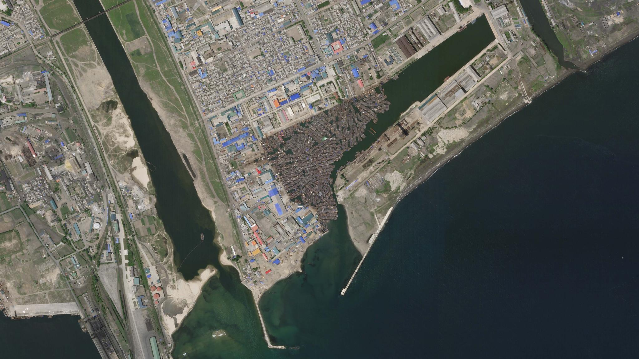
Small boats are anchored in a dockyard adjacent to the Port of Chongjin, North Korea. This Planet Skysat image was collected on June 3, 2020. © 2020, Planet Labs Inc. All Rights Reserved.
AUTHOR PROFILE Maya Midzik
Curious Planeteer working to make the Earth's changes visible, accessible and actionable.

Study Utilizes Satellite Data to Expose Illegal Fishing in North Korean Waters

Stories

A new study led by researchers at Global Fishing Watch and published in Science Advances this week shows how Planet’s Dove and SkySat imagery, in concert with other innovative technologies, was utilized to reveal widespread illegal fishing in the waters between the Koreas, Japan and Russia. The study showed the value of satellite imagery for exposing “dark fleets”—fishing vessels that don’t broadcast their locations in public monitoring systems—which can take part in illegal, unreported, and unregulated fishing practices. 

The study, Illuminating Dark Fishing Fleets in North Korea, found more than 900 vessels of Chinese origin in 2017, and 700 in 2018, likely violated United Nations (UN) sanctions by fishing in North Korean waters.

Researchers discovered that more than 900 vessels of Chinese origin in 2017, and 700 in 2018, likely violated United Nations (UN) sanctions by fishing in North Korean waters. It’s estimated that the vessels likely caught more than 160,000 metric tons of Pacific flying squid, worth over $440 million. Unidentified vessels create issues for squid stock management, according to the study, as the number of reported catches has dropped by about 80 percent since 2003. The research also revealed that approximately 3,000 North Korean vessels participated in illegal fishing in Russian waters in 2018.

Chinese pair trawlers in North Korean waters, captured by a Planetscope satellite on June 2, 2018. © 2018, Planet Labs Inc. All Rights Reserved.

“The scale of the fleet involved in this illegal fishing is about one-third the size of China’s entire distant water fishing fleet. It is the largest known case of illegal fishing perpetrated by vessels originating from one country operating in another nation’s waters,” said Jaeyoon Park, senior data scientist at Global Fishing Watch and co-lead author of the study. “By synthesizing data from multiple satellite sensors, we created an unprecedented, robust picture of fishing activity in a notoriously opaque region.”

Of course, Planet satellite imagery was only one piece of the puzzle when it came to illuminating these findings. Researchers also utilized radar images which can penetrate clouds, nighttime imaging, and the automatic identification system (AIS), which shows where some other nearby vessels are. 

A Chinese lighting vessel Planet Skysat on September 22, 2018. © 2018, Planet Labs Inc. All Rights Reserved.

“What makes this study so impactful is that all of these innovative technologies have never been used together to track activities and estimate catches of whole fleets at this scale,” says Dr. Joe Mascaro, director of Planet’s Education and Research Program. “This is the kind of research that increases transparency by providing neutral data that everyone can trust so they can make informed decisions.” 

As relevant governments investigate any breach of the UN sanctions banning fishing activity in North Korean waters by other UN Member States, satellite data can support nations who seek to increase their monitoring efforts—especially those who have limited resources for controlling illegal fishing across waters can greatly benefit countries committed to stamping out illegal fishing and enhancing monitoring efforts; and can serve to support nations with limited capacity and resources to control fishing activity in their waters.

“This study’s use of satellite technologies to detect dark fleets is unprecedented,” Mascaro says. “These results could totally change how we monitor transboundary fisheries going forward, ushering in a new stage where satellite imagery is a key tool for tracking illegal fishing activity.”