
The Nature Conservancy and Planet Collaborate to Map Blue Carbon
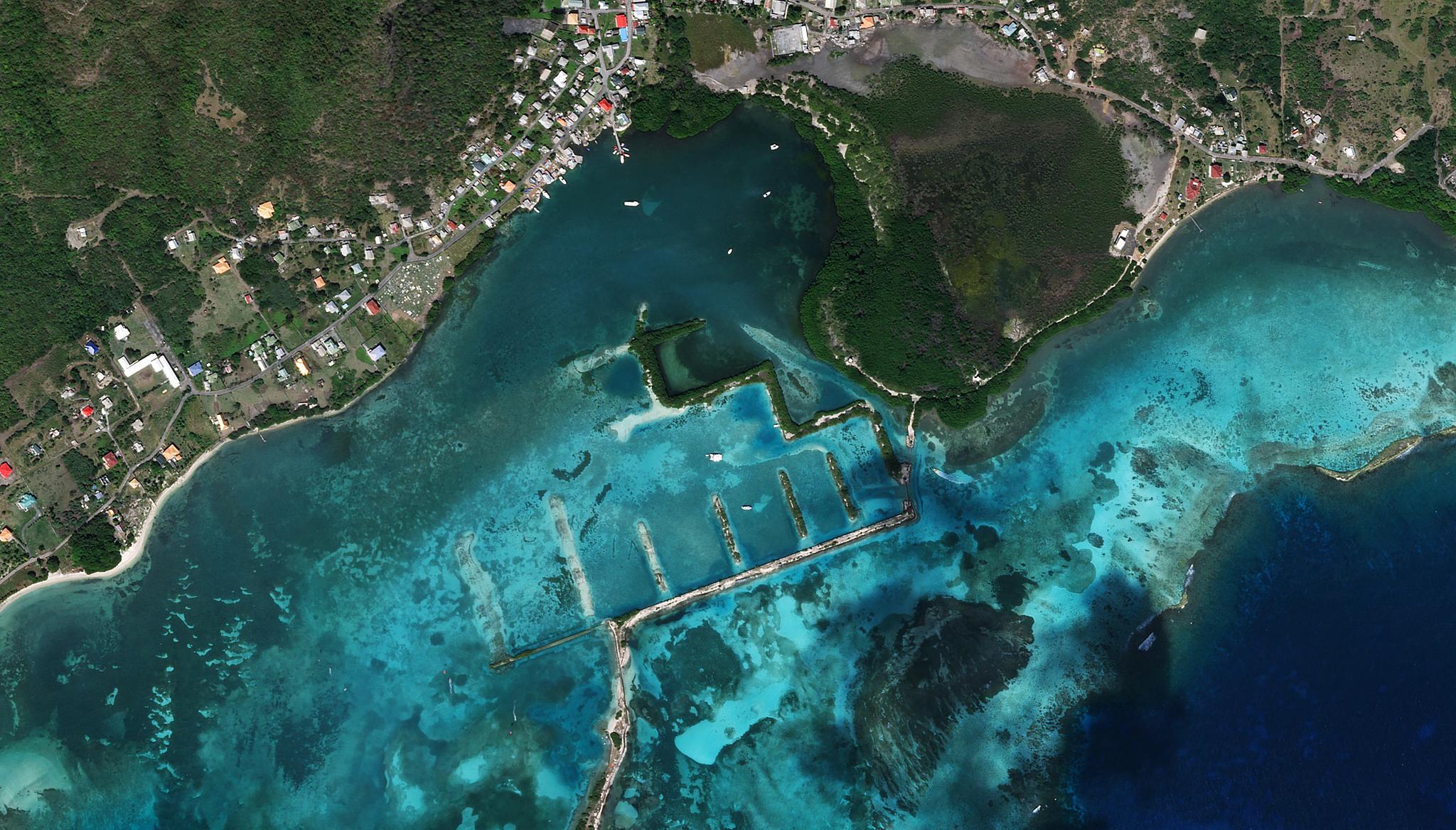
SkySat image of Ashton Bay, Union Island, Saint Vincent and the Grenadines taken January 18, 2023 showing coastal blue carbon resources including seagrasses and mangroves. © 2023, Planet Labs PBC. All Rights Reserved.
NewsMaking Waves with Blue Carbon
Trace your finger across a globe, around the edges of islands and continents, and soon enough, you’ll brush against some of the world’s most important ecosystems – the marshes, mangroves, and seagrasses that constitute the world’s “coastal blue carbon” stocks. Beyond their role in storing carbon, these ecosystems provide many important benefits to people and the planet, from supporting livelihoods and bolstering food security to providing storm protection and critical habitats for endangered marine species.
It is therefore unsurprising that, at the end of 2022, blue carbon was a major topic in global climate conversations. November’s COP27 bore witness to new standards for incorporating oceans into the Paris Agreement, and a first-of-a-kind framework to guide the development of high-quality blue carbon credits was launched. Countries around the world are working to increase protection and management of their blue carbon stocks. Today, we are proud to share how we’ve been working to further accelerate this blue carbon momentum by announcing our collaborative efforts on the Blue Carbon Explorer (BlueCarbon.TNC.org) - a tool developed by The Nature Conservancy (TNC) that aims to map mangrove and seagrass blue carbon around the world using Planet satellite data.
By now, many are familiar with how carbon is absorbed and stored by rainforests globally, but how about other diverse ecosystems? Coastal ecosystems can actually store up to 5 times as much carbon as upland forests. The world’s mangroves alone sequester more than 31 million tons of carbon in their soils and biomass each year. So, the protection and restoration of these environments is critical for supporting biodiversity, combating climate change, and helping communities to thrive, and new tools to map, monitor, and quantify these ecosystems are key to aid in their conservation. “These ecosystems really are a great ocean-climate link, and part of our strategy is to unlock this blue carbon potential for climate mitigation,” said Lindsey Smart, Climate and Ocean Scientist at TNC.
Monitoring Coastal Ecosystems From Space
The Blue Carbon Explorer is a Google Earth Engine app developed by TNC’s Caribbean Science team that provides detailed maps of mangroves and seagrasses to help governments evaluate the extent and health of these natural resources. TNC integrates field-collected data from drone and satellite imagery, including Planet’s PlanetScope and SkySat imagery, to visualize and identify key areas for restoration and protection, helping TNC and partners prioritize management and conservation activities.
A field team surveys mangroves from a drone in West Side National Park, Andros Island, The Bahamas. Credit: TNC/Steve Schill
“Thousands of PlanetScope scenes were used to derive the high-resolution mangrove and seagrass extent layers that the Blue Carbon Explorer relies on to perform analyses of temporal changes in habitat health and extract data on canopy height,” said Valerie Pietsch McNulty, Conservation Scientist for TNC’s Caribbean Division. “Planet’s data has been a game-changer for decision-making due to its high resolution because restoration sites can be very small, so having this level of granularity in the spatial data allows us to really target specific areas, within expansive mangrove patches.”
On the ground, TNC and their partners assess habitat health and carbon storage potential through a combination of underwater and drone surveys, soil coring, and collection of plot-level aboveground biomass estimates, but this process can be time and energy intensive and limited in extent. TNC is now identifying relationships between this field data and satellite-derived measurements (optical and radar) so that the field information on ecosystem health and carbon storage potential can be scaled across large expanses of coastal habitat with Planet’s satellite data.
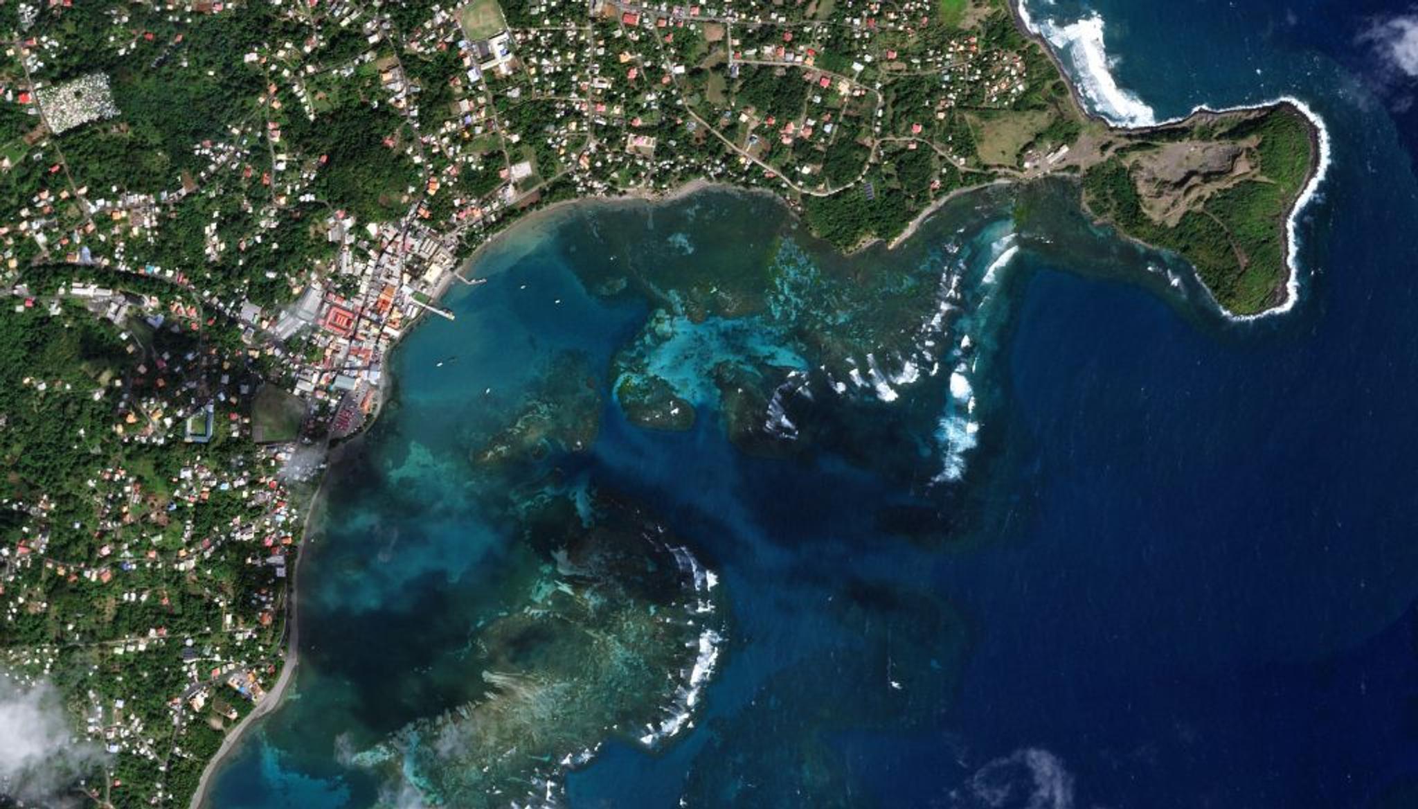
SkySat image of Grenville Bay, Saint Andrew Parish, Grenada showing increased details on seagrasses in the region taken February 21, 2023.
“Planet offers us an unprecedented ability to look through a daily archive of imagery and select the very best scenes that are suited for looking underwater. That requires certain conditions - lower tides, calm water, no cloud cover or sun glint,” explained Dr. Steve Schill, Lead Scientist for the Caribbean at TNC. “This data permits us to visualize the dynamic nature of blue carbon habitats at a level of detail that previously has not been possible; and we can do this systematically across hundreds of islands and thousands of square kilometers of mangroves and seagrass beds.”
The Blue Carbon Explorer displays a 2015-2021 Normalized Difference Vegetation Index (NDVI) change analysis for Old Harbour Bay, Jamaica, highlighting areas of mangrove loss and growth.
This work is providing novel insights on these coastal ecosystems which have never been reported on in such depth, extent, and precision. The tool has already started to reveal insights into changing coastal habitats throughout the Caribbean, Indonesia, and Papua New Guinea. And this is just the beginning. Leveraging Planet data and new techniques in AI, as well as lessons learned from the Blue Carbon Explorer, these insights can be used to better understand coastal habitats around the world.
“Mapping coastal blue carbon is a critical step in securing these vital carbon stocks – and the immense social, ecological, climatological and economic value they represent,” said Planet’s Chief Impact Officer Andrew Zolli. “By combining TNC’s expertise with Planet’s breakthrough Earth observation capabilities, the Blue Carbon Explorer makes these benefits visible and accessible to a wide variety of stakeholders. It’s a vital tool for advancing a scientifically rigorous, just, and inclusive transition to a more climate-stabilized future.”
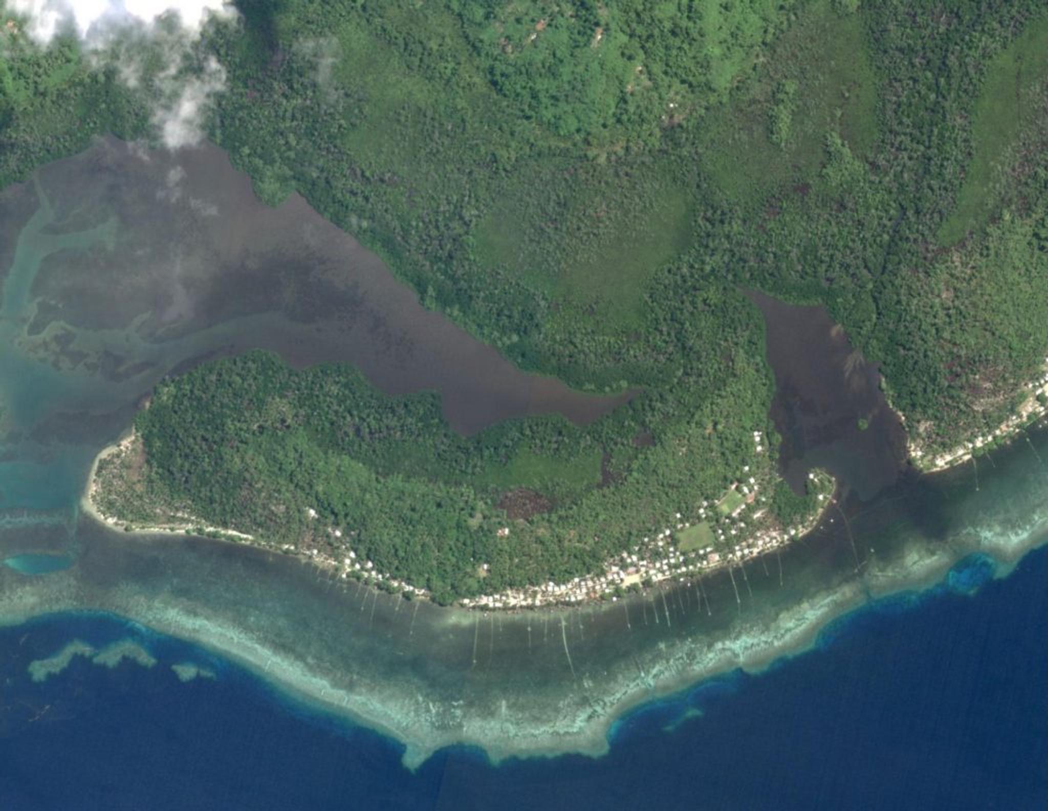
SkySat image of Sanders Island, Manus Province, Papua New Guinea showing details on mangroves in the region taken on March 12, 2022. Planet image provided by TNC.
Carbon Credit Markets
By offering such a robust amount of scientific data, these tools could help provide the means for bringing these blue carbon resources to the market. In today’s current carbon market, verifiable data enables governments to receive global incentives to protect and restore their carbon sinks. For some, this process can financially support conservation efforts and encourage sustainable economic initiatives.
“In terms of carbon accounting, we really need high resolution globally consistent datasets because these systems are pretty dynamic,” said TNC’s Smart. “It’s really important to accurately quantify the carbon sequestered and stored in these systems and the changes through time. The fact that Planet data can be leveraged to do these things is a huge value add, especially for scaling blue carbon market projects.”
For some governments, the Blue Carbon Explorer has already helped reveal previously unknown mangrove and seagrass resources, informing them about the extent of these valuable resources, growing right along their shores. With archives of Planet imagery, nations could be able to provide verifiable data to help report their progress on protection and restoration efforts and bring these resources to market.
“One of the biggest gaps we have is localized site data in order to make carbon market projects work. Having Planet data is critical for us to justify and show the carbon content, the dynamics of the system in and of itself in terms of loss rates and gains,” said Emily Landis, Climate and Ocean Strategy Lead at TNC. “This is already starting to help us as we’re trying to prioritize locations and understand where we’re going to find the biggest return on investment for carbon.”
Stakeholder Engagement
Mangroves offer a wealth of ecosystem services, not only sequestering carbon, but also protecting coastal communities from storm surge and flooding, serving as a nursery for commercial fish species, and supporting eco-tourism and outdoor recreation. Mangrove restoration provides an opportunity for governments to invest in climate mitigation and adaptation strategies simultaneously, as well as sustainable livelihoods and biodiversity. TNC deeply emphasizes the need for stakeholder knowledge alongside science to prioritize habitat areas for restoration. They have conducted extensive workshops and research with local communities and government leaders in building the tool and applying it to scale-up restoration efforts on the ground.
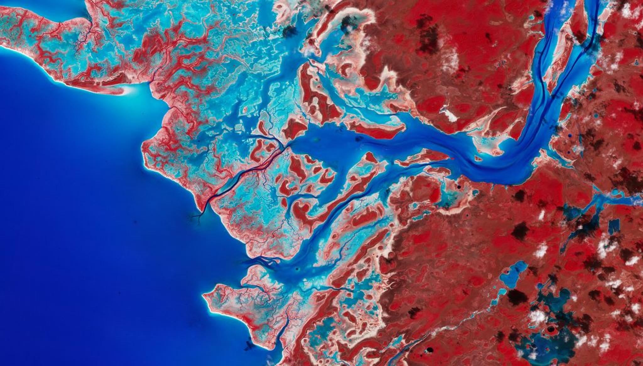
PlanetScope image & NIR false color composite of coastal vegetation in Tarpon Town, Andros Island, The Bahamas taken February 10, 2023. The red coloring in the NIR false color composite indicates vegetation.
“When prioritizing where to restore coastal habitats, it is critical to include the people component and identify areas where climate change is having the most impact. Socioeconomic indicators can be analyzed to model human vulnerability and restoration efforts of mangroves and seagrass beds can take place where they benefit the people who need them most,” explained TNC’s Schill. Using Planet’s satellite data, TNC can more accurately map both ecological and economic features that help to “zero in on the areas where the resilience of a coastal community can be improved and the benefits of coastal protection and enhanced livelihoods and human well-being are aligned.”
Their team was led by a guiding principle that this science should be given back to the countries where these habitats exist. “They really do view the science as their national sovereignty. So, we’re making sure that when we’re doing this science, it’s getting into the hands of the people who make decisions and they feel ownership,” said TNC’s Landis.
A field team conducts drone surveys over mangroves in West Side National Park, Andros Island, The Bahamas. Credit: TNC/Steve Schill
The Blue Carbon Explorer and these newly completed mangrove maps are already being put to work by The Nature Conservancy and conservation partners in The Bahamas. Many of the mangroves on Grand Bahama and Abaco were devastated during Hurricane Dorian in 2019. Based on guidance from partners on the ground, TNC is using the tool to guide expansion of restoration sites towards priority areas of mangrove that are not likely to recover naturally. Meanwhile, partners are identifying and testing mangrove restoration methods that can be scaled up, such as direct outplanting, wave dispersal, and the use of drones to drop propagules in hard-to-reach areas. Utilizing a science-driven process, this partnership aims to restore mangroves as quickly and efficiently as possible to meet conservation goals.
To learn more about TNC's Blue Carbon Explorer, hear their team speak at Planet's Explore 2023 Conference next week, April 12th-13th, in Washington, D.C. Register today!
Ready to Get Started
Connect with a member of our Sales team. We'll help you find the right products and pricing for your needs.