This mosaic of Mars is a compilation of images captured by NASA’s Viking Orbiter 1. Image courtesy of NASA, JPL-Caltech.
AUTHOR PROFILE Tanya Harrison
Curious Planeteer working to make the Earth's changes visible, accessible and actionable.

Venturing to Mars on Earth with the Help of Planet Data

Stories

Dr. Anna Grau Galofre of Arizona State University and her colleagues are using PlanetScope imagery to help learn more about life on Mars.

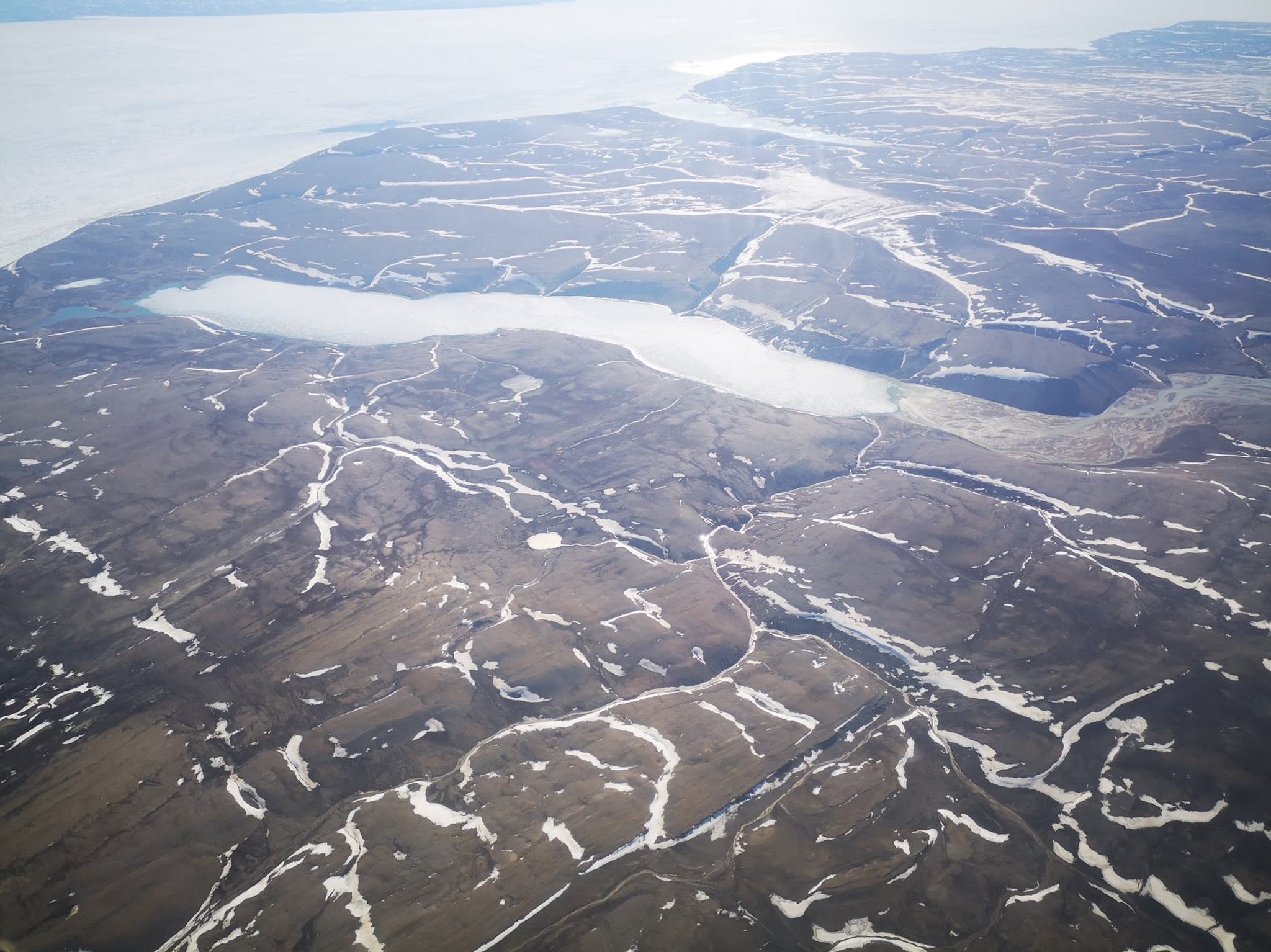
Grau Galofre and her team are analyzing the terrain of Axel Heiberg Island in the Canadian High Arctic, with the aim of observing channels carved by melting glaciers. What makes these channels particularly unique is that they bear a striking resemblance to distinct-looking channels on Mars, carved hundreds of millions of years ago.  Since there are only a handful of places on Earth that mimic Mars in terms of climate and landscape, this makes Axel Heiberg Island extremely valuable to the study of the Red Planet.

Looking at such places helps us understand what Mars was like in its ancient past! Many of the features on the surface of Mars today are relics of its former climates. Using observations from PlanetScope imagery paired with aerial imagery collected via helicopter, as well as ground-based data, scientists like Grau Galofre can piece together findings from places like Axel Heiberg to hypothesize how martian features might have formed. 
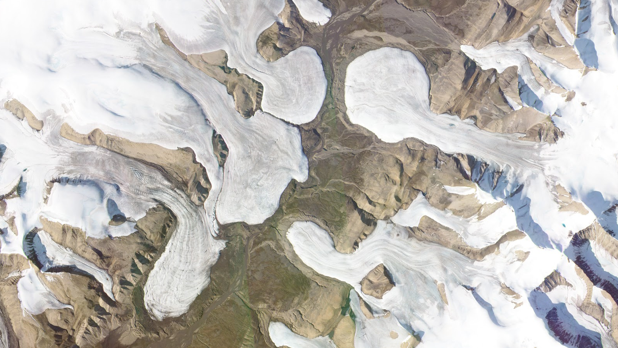
This research was made possible thanks to Arizona State University’s campus-wide Education and Research (E&R) License for Planet imagery. Enabling access to the entire PlanetScope catalogue of daily coverage of Earth, our E&R licenses open up a treasure trove of data for students, professors and other academics to delve into insights about our ever-changing world.

In the Arctic, snow on the ground can bury geologic features of interest. This is where Planet’s data is particularly useful. “Access to daily imagery around the island meant our team could quickly tell if our sites of interest were still snow-covered or not,” Grau Galofre remarked. This resulted in their visiting more targets this past summer than in previous years, increasing the scientific return of their expedition. On the uninhabited island, there are no roads, so getting around requires helicopter time costing thousands of dollars per hour. Therefore, being able to tell in advance where the channels are visible on a specific day save both time and money.

Axel Heiberg Island is home to a unique cold polar desert. It gets an average of 58 millimeters of precipitation each year. (For comparison, Phoenix, Arizona gets nearly four times that much rainfall annually.) While the word “desert” likely evokes visions of hot, vast, sandy regions—which is usually the case on Earth—a select few cold deserts exist, where the climate is dry but freezing. And this is what makes Axel Heiberg Island special.

Networks of subglacially-carved channels on Axel Heiberg Island. Image credit: Anna Grau Galofre.

The above image shows networks of subglacially-carved channels on Axel Heiberg Island. Image credit: Anna Grau Galofre.

In most places on Earth, glaciers behave in a “wet-based” manner. Axel Heiberg Island is one of the few places on our planet where glaciers are “cold-based”—rather than sliding atop a layer of meltwater like Earthly glaciers usually do, these glaciers stay solidly frozen to the underlying rock.

Planetary scientists studying Mars generally think that glaciers in the ancient martian past were cold-based, as the planet lacks much in the way of evidence for geologic features left behind by flowing glaciers.

The ice ages covered North America with wet-based glaciers that were kilometers thick. These glaciers left behind key diagnostic features such as moraines (piles of rocks and sediment pushed around the edges of glaciers) and scour marks formed by the ice as it scraped across the landscape. While some glaciers have been spotted on Mars even today, searching for typical features signalling widespread extent of glaciers and ice sheets on the Red Planet has proven more elusive.

Glaciers spill into a barren valley on Axel Heiberg Island, Canada. PlanetScope image collected on August 15, 2019. © 2019, Planet Labs Inc. All Rights Reserved.

Planet imagery shows glaciers spilling into a barren valley on Axel Heiberg Island, Canada. PlanetScope image collected on August 15, 2019. © 2019, Planet Labs Inc. All Rights Reserved.

Grau Galofre thinks this elusiveness comes from the fact that we’ve been looking for the wrong features. If glaciers on the Red Planet were cold-based, then “the same glacial landforms that formed under ice sheets on Earth would not be observed on Mars,” Grau Galofre says.

Instead, she says some of Mars’ famous valley networks—first imaged by NASA’s Viking Orbiter space probes back in the 1970s—might be the key piece of evidence that’s been overlooked for decades.

Grau Galofre’s team found that when the cold-based glaciers on Axel Heiberg Island melt, they carve dendritic (tree-like) channels beneath the glaciers themselves. As the water flows out beyond the snout of the glacier, the channels continue onward, now visible at the surface.

Parana Valles, one of Mars’ more striking valley networks, as imaged by the Viking 1 orbiter in 1976. The image spans ~250 km across. Image credit: NASA/JPL-Caltech.

This image shows Parana Valles, one of Mars’ more striking valley networks, as imaged by the Viking 1 orbiter in 1976. The image spans ~250 km across. Image credit: NASA/JPL-Caltech

To Grau Galofre, these channels look similar to some martian valley networks.

“Looking at these valleys is like doing forensic work,” she says. “We want to understand what goes on beneath the ice sheets at Axel, and what that implies for Mars.”

And those implications could be huge, according to Grau Galofre. “If some valleys on Mars turn out to have originated beneath ice sheets, this can change our understanding of the history of water on Mars.”

But studying these glaciers doesn’t just tell us about Mars. This research also has big implications for Earth.

Grau Galofre notes that looking at how glaciers are draining is important for predicting the loss of ice due to the effects of climate change. This makes continued monitoring of the region with Planet data important—for both Earth and our next-door neighbor. Grau Galofre’s team recently presented this work at the 7th International Conference on Mars Polar Science and Exploration in Ushuaia, Argentina.

If you’re interested in utilizing Planet data for your research, you can find more information about our E&R licenses by following this link.