
Data Program Continues to Use High-Resolution Satellite Imagery to Help Fight Deforestation and Combat Climate Change
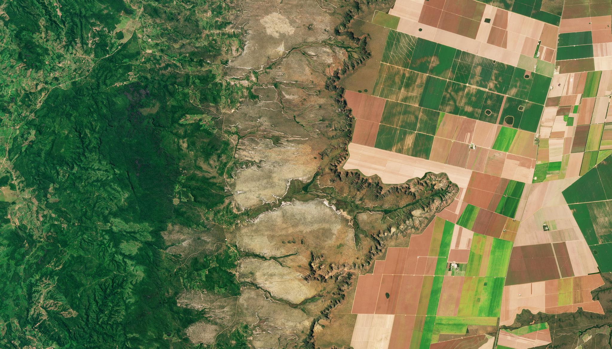
Planet image of tropical rainforest NICFI research site taken March 26, 2022. © 2022, Planet Labs PBC. All Rights Reserved.
StoriesThe NICFI Satellite Data Program continues to serve a diverse community of users that are putting high-resolution satellite imagery to work in helping fight deforestation and combat climate change.
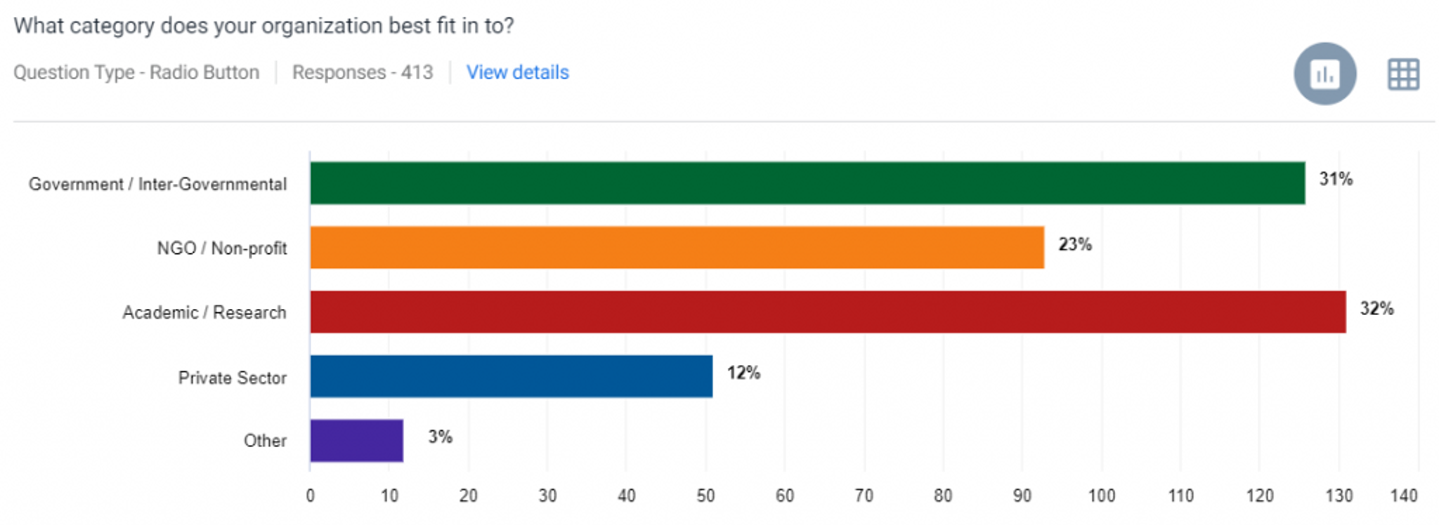
This quarter, we conducted our third user survey of Level 1 users. We received over 400 responses from users, detailing their feedback, user stories, and more! The community is growing and we are seeing a larger breadth of organizations, geographies and topics being represented (Fig 1).
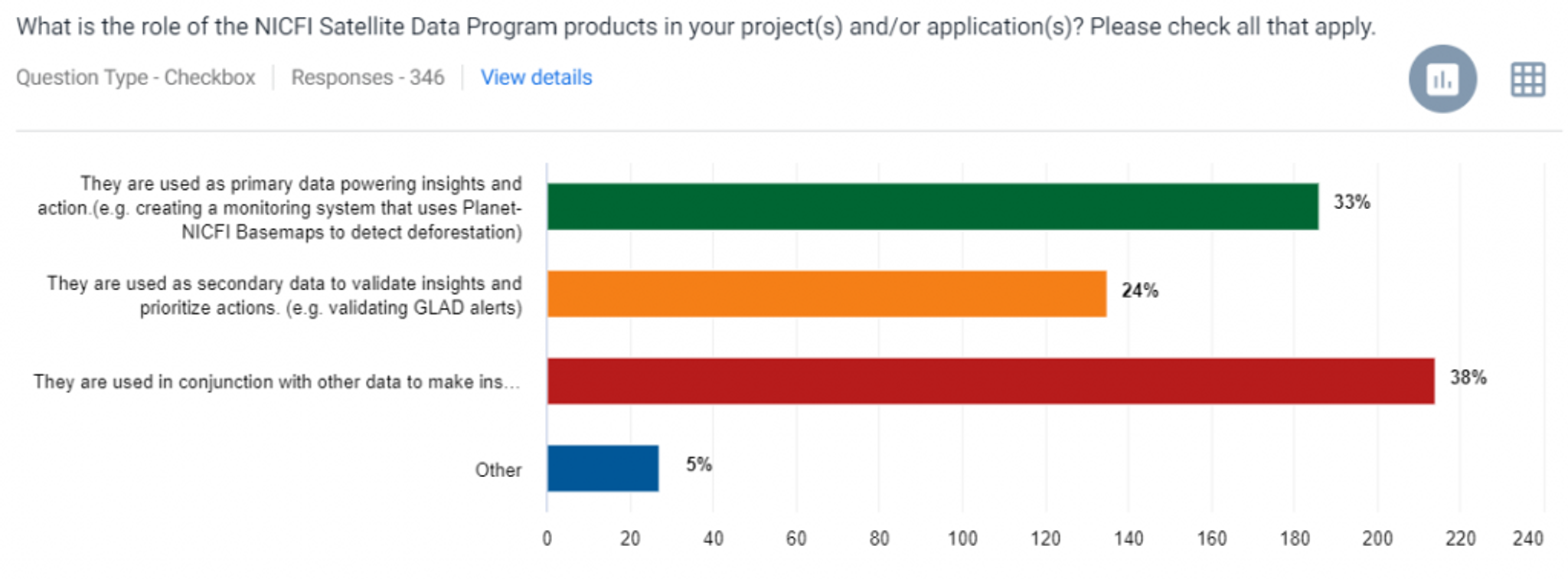
In addition to a growing number of applications and use cases, we also noticed a growth in the number of users that are using the NICFI Satellite Data Program high-resolution datasets, including PlanetScope and SPOT, in conjunction with other publicly available datasets such as Landsat, Sentinel, and MODIS (Fig 2). We think it’s great to see these datasets used interoperably for even more insights on forests & climate.
Here’s just a few of the many user stories we collected this quarter - from across the private, public, academic and nonprofit sectors:
- Private Sector:
- Nusantara Atlas used the NICFI Satellite Data Program to demonstrate that palm oil related deforestation in Indonesia has slowed throughout 2022. Their analyses help link geospatial insights on land conversion to asset- and supply- insights (e.g., which companies are responsible for conversions) from concession data.
- Satelligence is a recognized leader in deforestation monitoring. They use high resolution radar (Sentinel-1) and optical (Landsat, Sentinel-2) data which is then complemented with NICFI Satellite Data to increase awareness and trust in clients by visually showing evolution of deforestation events.
Time lapse animation revealing clearing and draining of peat swamp forest in preparation for oil palm in North Kalimantan, Indonesia. Created using NICIF Satellite Data Program Basemaps. Processed in Nusantara Atlas. Nusantara Atlas then cross-checks this geospatial data with concession data to link insights to specific supply chains. Source: Palm Oil Related Deforestation Keeps Slowing in Indonesia in 2022.
- Media:
- The New York Times, in partnership with The Pulitzer Center on Crisis Reporting and The Intercept, used the NICFI Satellite Data Program’s Level 2 access to detect, verify, and show airstrips linked to illegal mining activities in the Brazilian Amazon rainforest. The journalists leveraged both PlanetScope’s daily monitoring and Airbus’ SPOT archive in their investigative and transparency work. Level 2 users are strategic partners defined by Norwegian Ministry of Climate and Environment.
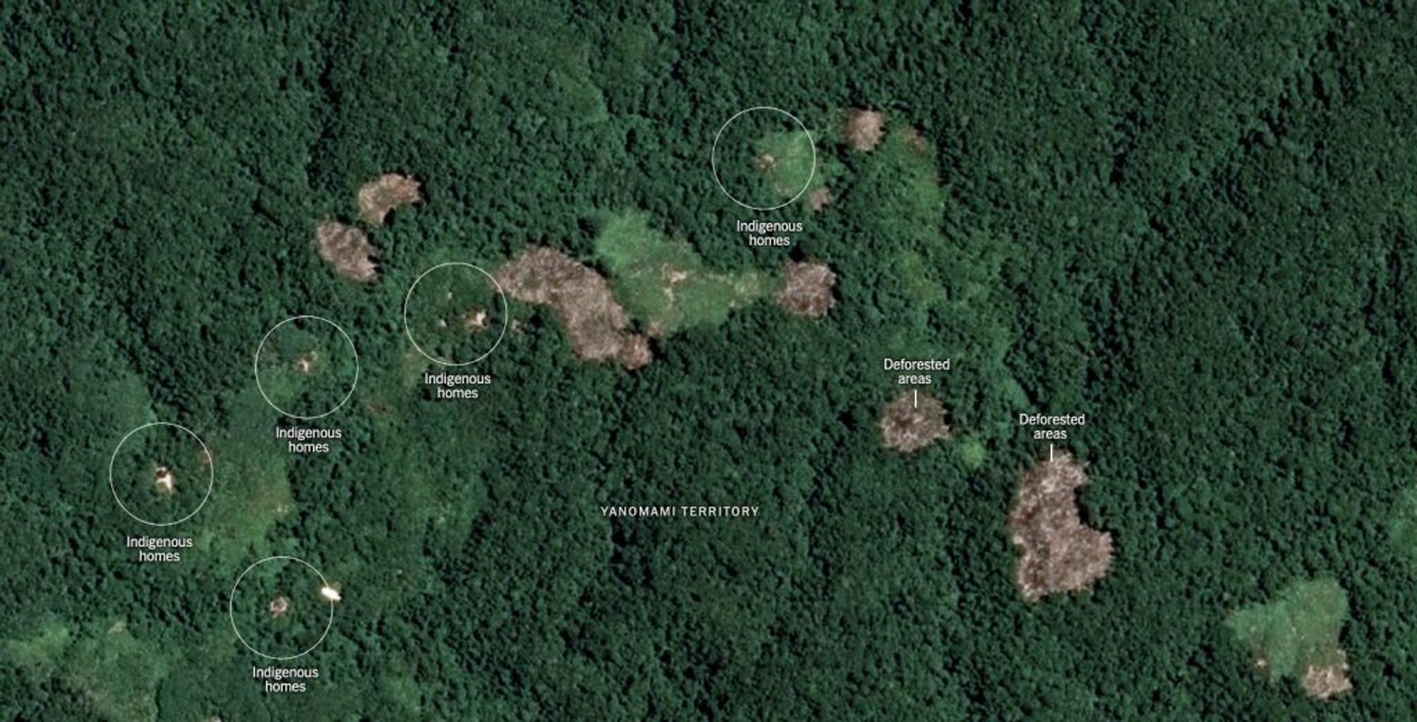
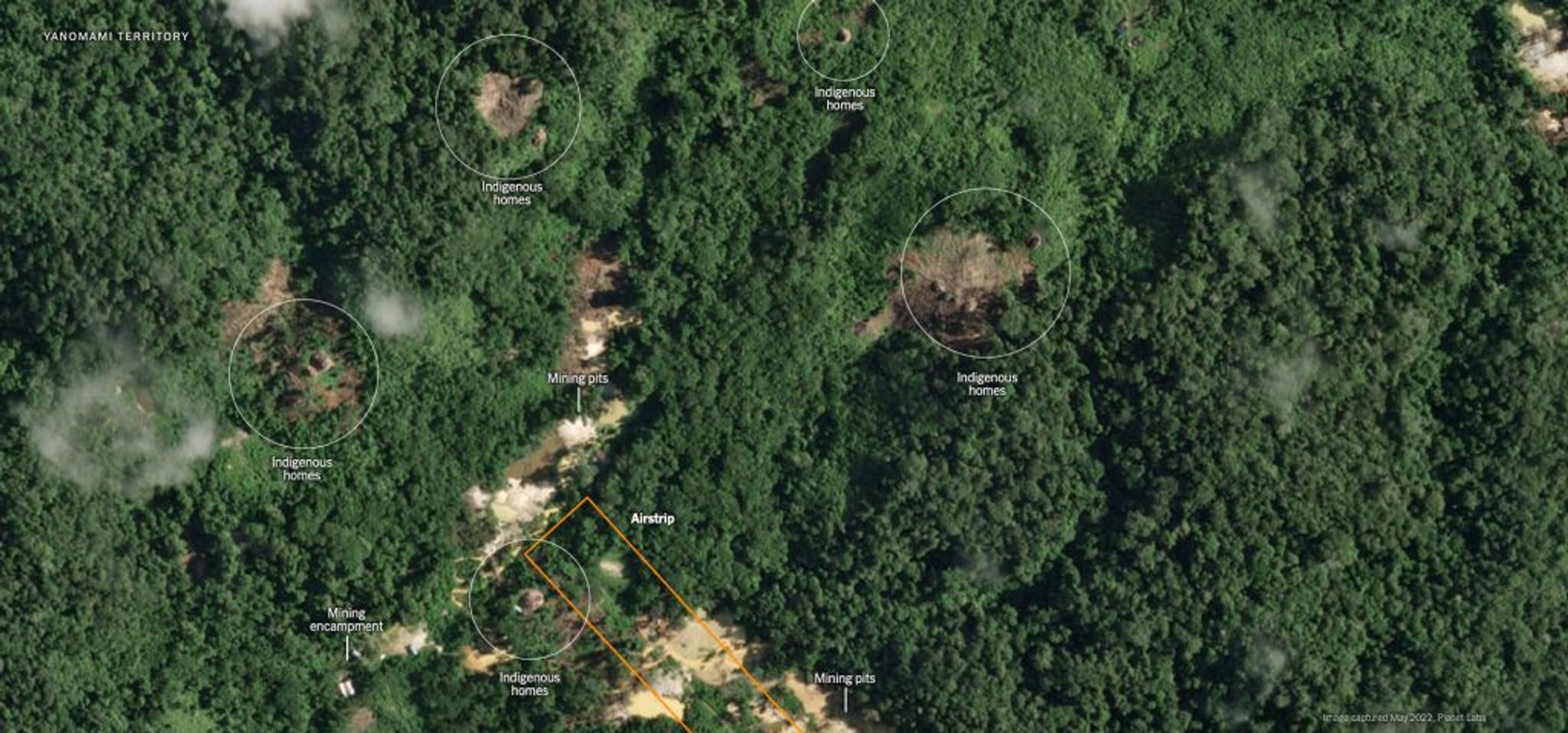
Airbus SPOT archive data from 2019 (top) and PlanetScope monitoring data from May 2022 (bottom) show clear growth of airstrips and mining pits in indigenous territories of the Brazilian Amazon. Source: NICFI Satellite Data Program and New York Times. SPOT 6/7© Airbus DS 2019
- Government:
- The Government of South Sudan, in partnership with UN-FAO, is putting the Level 1 and Level 2 data to work to improve land cover, land use, and forestry mapping.
- Programa Vision Amazonia, working across Brazil and Colombia, is using the NICFI Satellite Data program to assist in the digital processing of remote sensing images for the detection of deforestation and fires in the Amazon region.
- The Environmental Secretary of the State of Rondonia (SEDAM-RO) in Brazil is putting the NICFI data to work to monitor forest area and change estimations, particularly for deforestation related to the development of dams in the region.
- Science:
- The Amazon Institute for Scientific Research (SINCHI) is leveraging the NICFI Satellite Data Program to generate maps that identify deforestation and wildfire risk ‘hot spots’ across the Amazon basin. They note, “The frequency and quality of the images has allowed us to more effectively generate early warnings to identify hot spots and areas in the process of deforestation.”
- The University of California at Los Angeles researched, developed, and published new capabilities for automated detection and mapping of forest degradation leveraging the wall-to-wall, <5m/px resolution of the pantropical Planet-NICFI mosaics (Level 1 data).
We look forward to continuing to learn from and support this user community in their critical work to support the Purpose of Norway’s International Climate & Forests Initiative!
Ready to Get Started
Connect with a member of our Sales team. We'll help you find the right products and pricing for your needs.