
Global Heritage Fund Leveraging Planet SkySat to Protect the Cultural Fabric of Ukraine
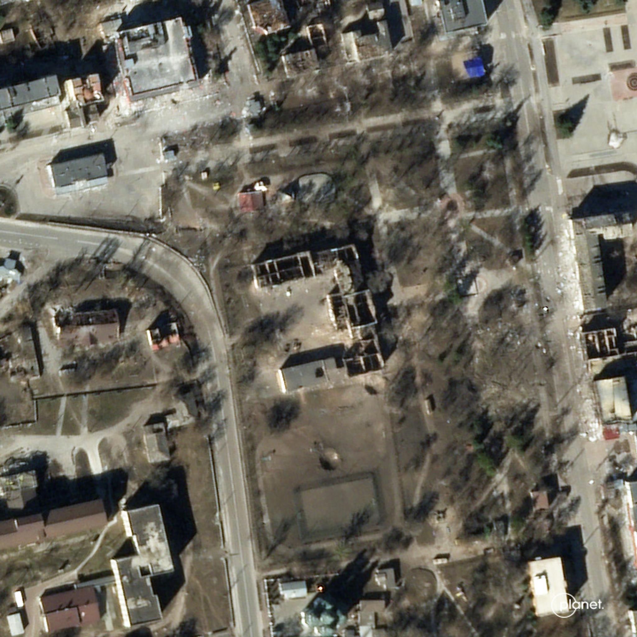
Planet SkySat data of a Realne Uchilishe a college building from 1882 captured on March 22, 2022. © 2022, Planet Labs PBC. All Rights Reserved.
StoriesUNESCO reported in July 2022 that over 165 Ukrainian heritage sites have been damaged since the onset of the Russo-Ukrainian war, and warned that further destruction lies ahead. With Ukraine’s cultural landscape under continued threat, the need to safeguard the country’s heritage is felt, not only within Ukrainian borders, but also globally with international organizations on the ground working to keep Ukraine’s national identity intact. One such organization, Global Heritage Fund, a California based non-profit that transforms local communities by investing in cultural heritage to advance economic development, is teaming up with University College London (UCL) to map cultural heritage site destruction using Planet imagery.
This project aims to perform a quantitative assessment of urban areas severely affected by the conflict. The data is the base for future reconstruction plans. By focusing on change detection, Global Heritage Fund and UCL will use this imagery, alongside local knowledge from informants onsite, to perform supervised classification of urban texture, highlight areas destroyed, and quantify the damage inflicted upon Ukrainian cultural heritage sites.
“For Global Heritage Fund, preserving the cultural fabric of a place encompasses protecting historical buildings as well as conserving locations that stimulate the arts, foster social innovation, and advance economic development,” explained Nada Hosking, Executive Director of Global Heritage Fund.
Global Heritage Fund and UCL teams are using Planet satellite imagery to document sites of Ukrainian heritage value. Using our SkySat tasking capabilities, they are collecting high-resolution images of attacked regions, and where possible supplementing the data with ground validation via local specialists. This project, titled “Under Fire Heritage of Ukraine,” creates a baseline database of Ukrainian cultural heritage – a digital geospatial inventory of sites that are under threat of looting, forceful appropriation, or deliberate erasure during the war.
“We are working quickly to capture and categorize before and after images. This view of change over time is crucial for rapid and cost-effective reconstruction of heritage sites,” said Dr. Gai Jorayev, a research fellow at UCL Institute of Archaeology. “The aim is to make this database accessible to Ukrainian colleagues so it can contribute to, or become core of, the national geospatial monument inventory system.”
The project, funded in part through a grant from the International Alliance for the Protection of Heritage in Conflict Areas (ALIPH), will create a centralized inventory for Ukraine through the systemic digitization of satellite images, maps, and aerial photography of significant architecture, pulling from historic archives and modern SkySat satellite images. A top priority of the project is to provide swift recommendations for how to protect and stabilize artifacts, buildings, and monuments as the situation evolves. Both the database and recommendations are intended to provide long-term value to the Ukrainian Ministry of Culture.
The project tasks SkySat satellites following damage tips from specialized informers on the ground and media reports of destroyed or attacked locations. The images are used to validate damage to particular locations, especially when photos cannot be obtained without putting people in harm’s way.
Hosking noted that documenting locations in conflict areas can be challenging as local authorities often discourage citizens from taking pictures of significant sites, whether damaged or not. Historical landmarks may be deliberately attacked in strategic warfare and authorities try to avoid adding data to systems, which could be hacked to target locations.
Planet SkySat data of a Realne Uchilishe (UKR - Реальне училище, Ger – Realschule), a college building from 1882, captured on March 12, 2022. It is registered as the monument of history and archaeology of local significance. Credit: Planet Labs PBC
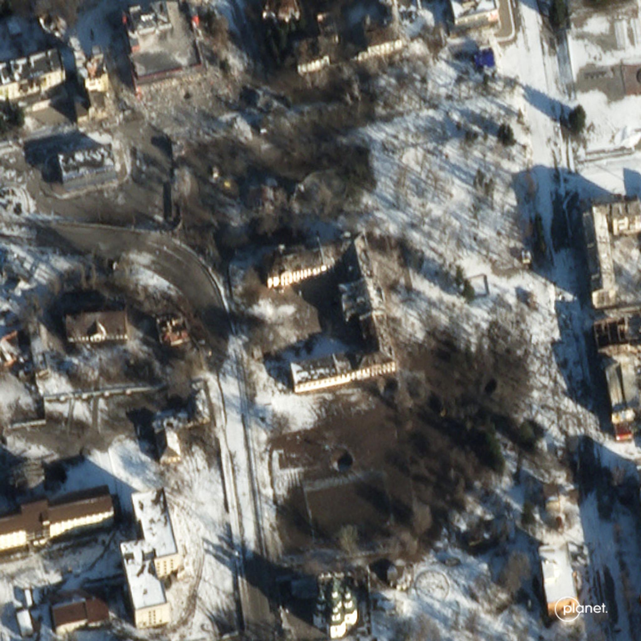
Planet SkySat data of a Realne Uchilishe (UKR - Реальне училище, Ger – Realschule), a college building from 1882, captured on March 22, 2022. It is registered as the monument of history and archaeology of local significance. Credit: Planet Labs PBC
Why geographic intelligence matters
Since 2010, Global Heritage Fund has worked with Esri to build a global heritage network - a database of endangered heritage sites that relies on the general public rather than trained experts for data input. With smartphone adoption growing exponentially in the last decade, the organization took a mobile first approach and developed the AMAL in Heritage app to enable people to document and geotag sites and objects during conflict, erosion, or severe storms like hurricanes. The app works offline on any smartphone, allowing people to take pictures and annotate them in the field in real time.
“We work with communities and their vernacular architecture, as well as public monuments,” Hosking explained. “But as an organization we prefer to focus on cultural landscapes, places where the architecture is informed by the geography and where a symbiotic relationship between human activity and the environment exists. The organization helps to create value in these cultural places, helping communities to manage their resources with partners and supporting capacity building of local people.”
Global Heritage Fund has completed a broad range of heritage projects - fromprotecting archeological wonders of Indigenous communities in Colombia torebuilding sacred granaries and economic well-being for rural communities in Morocco. In Pingyao, China, homes were restored and talented elderly members of the society were employed to revive endangered traditional arts and preserve craftsmanship. In Beirut, Lebanon, Global Heritage Fund used AMAL in Heritage to respond to the August 2020 explosion that damaged 8,000 historic buildings. They documented 200 buildings in three days, providing data to the Lebanese Ministry of Culture and Directorate General of Antiquities that is crucial to the restoration efforts.
“In Beirut, AMAL synthesized data about the location and extent of damages sustained to enable rebuilding. In Ukraine, we are collecting as much data as possible,” explained Hosking. “These images will be used for post-war reconstruction. It is important to be proactive and safeguard this heritage where possible. The cultural identity of the Ukrainian people is on the line.”
Planet and humanitarian support in Ukraine
“This war will have lasting effects on Ukraine and the world, but we are proud to know that our imagery can provide a digital cultural baseline for reconstruction. These historical buildings, and places of cultural significance are so crucial for maintaining the vital and strong culture of Ukraine,” said Andrew Zolli, Planet’s Chief Impact Officer.
Global Heritage Fund is one of 30 NGOs and intergovernmental bodies Planet is working with and supplying data to that are supporting a number of humanitarian operations in Ukraine, including: civilian evacuation; planned demining operations; conducting building damage assessments; tracking alleged human rights abuses; and trying to mitigate andmeasure impacts to food supplies.
Ready to Get Started
Connect with a member of our Sales team. We'll help you find the right products and pricing for your needs.