© 2016, Planet Labs Inc. All Rights Reserved.
AUTHOR PROFILE Shelby Parks
Curious Planeteer working to make the Earth's changes visible, accessible and actionable.

How Amazon Conservation is Cracking Down on Illegal Mining with Planet Data

News

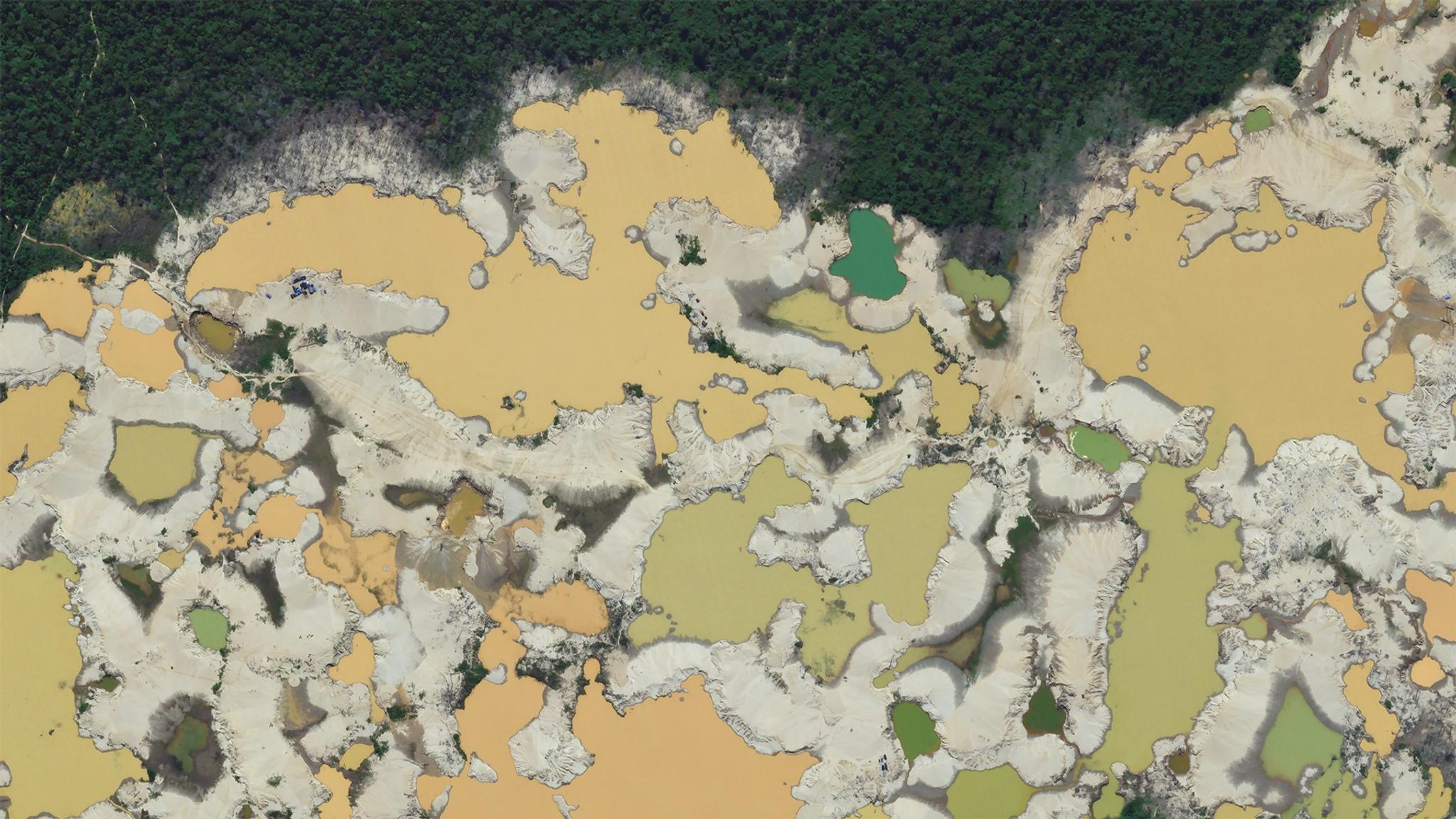
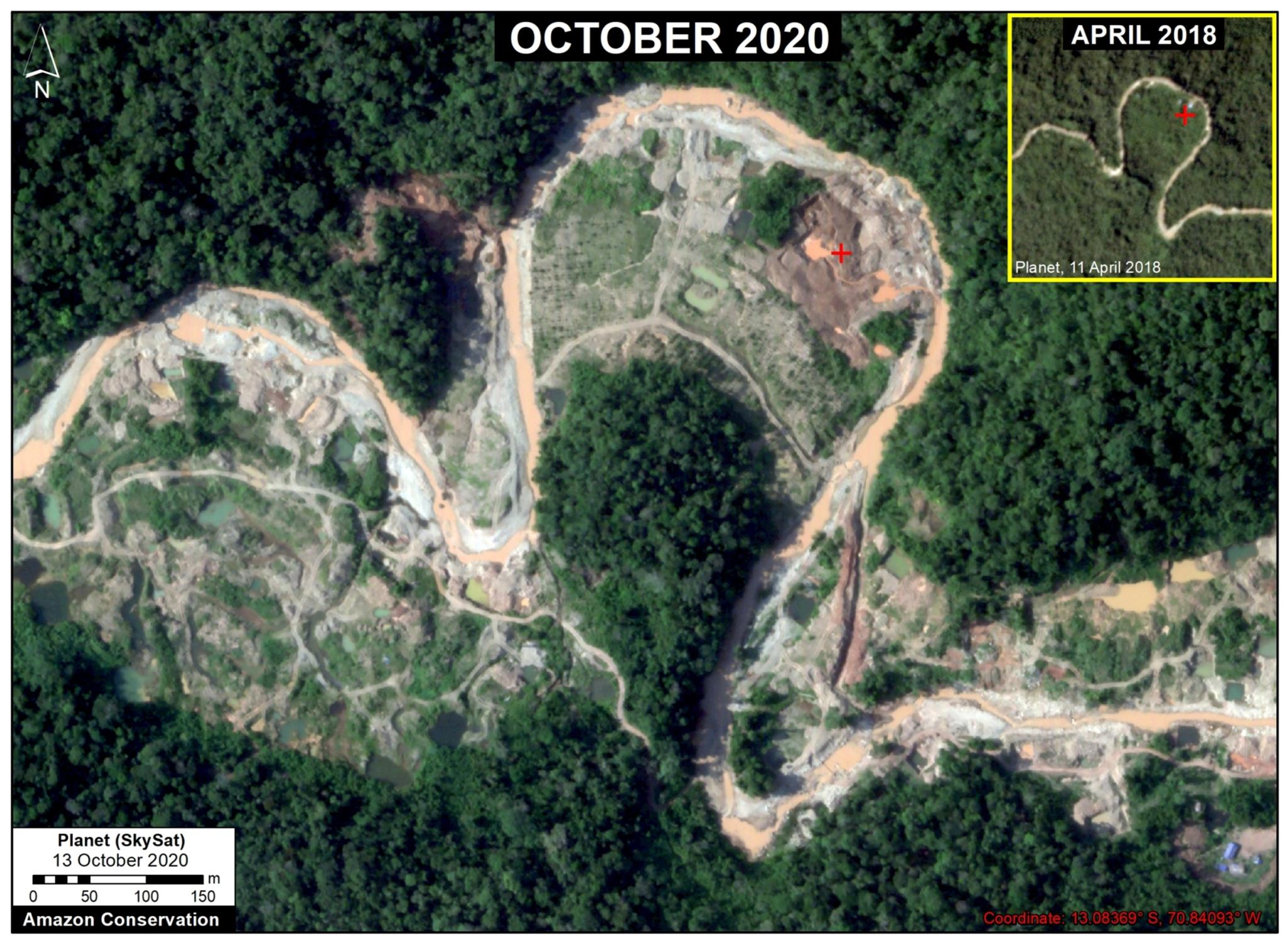
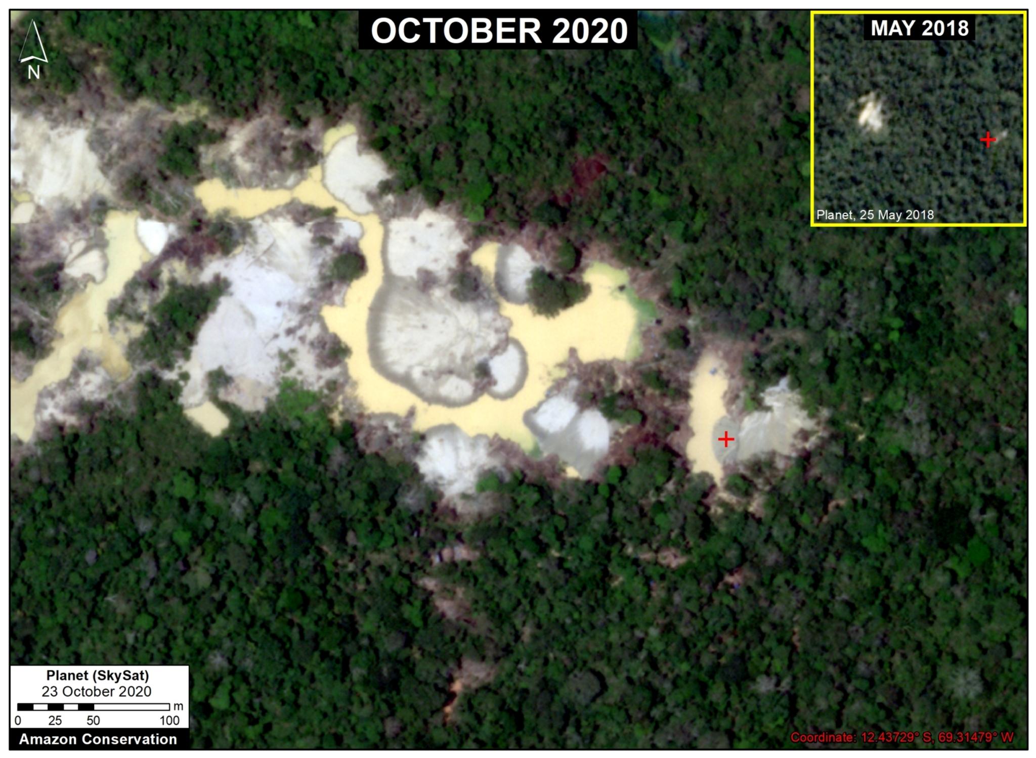
For the past two decades, Amazon Conservation has protected over 8.15 million acres of rainforest in Peru and Bolivia. The Amazon Conservation develops innovative research and solutions through science and technology at their living laboratories that have provided tools to government and forest users to protect their lands while empowering hundreds of indigenous communities. One initiative that was born out of the DC-based Amazon Conservation is MAAP (Monitoring of the Andean Amazon Project). This initiative, which launched in 2015, is dedicated to presenting original analysis related to the field of real-time deforestation monitoring. 

“The vastness of the Amazon can be a major challenge to its conservation, but technology, especially satellites, have emerged as an extremely powerful tool,” said Dr. Matt Finer, Senior Research Specialist at Amazon Conservation and Director of their Monitoring of the Andean Amazon Project (MAAP). “With the latest generation of satellites and related algorithms, we have been able to go from annual to more real-time monitoring. And it is this real-timeness that makes all the difference in linking this technology with effective policy action on the ground to reduce and avoid deforestation.”

As a young and dynamic field, real-time deforestation monitoring requires the MAAP methodology to monitor change over time. 

“Planet has been at the core of our methodology since 2016,” said Finer. “At MAAP, we are not married to any particular technology, we are always just seeking out the best available tools. And Planet has been the best imagery source for real-time monitoring since 2016.”

MAAP aims to document the most urgent deforestation cases in near real-time and identify the direct causes of deforestation in the Andean Amazon. In doing so, MAAP is able to better understand larger-scale deforestation patterns, hotspots, and drivers. With this information, MAAP is able to improve policy and conservation action based on this cutting-edge technical information. 

“Our primary audience is decision-makers and government officials who have the ability to incorporate this information in official policy. An additional important audience is civil society, journalists, researchers, and the public, who get together to help create pressure to drive policy. We hope the end result is reduced deforestation,” said Finer. 

Recent expansion of gold mining deforestation in the buffer zone of Amarakaeri Communal Reserve (Cusco region). © 2020, Planet Labs Inc. All Rights Reserved.

Recent expansion of gold mining deforestation in the buffer zone of Amarakaeri Communal Reserve (Cusco region). © 2020, Planet Labs Inc. All Rights Reserved.

Enter: Operation Mercury

Using Planet imagery, MAAP partners with Peruvian government officials and police to train them on the use of satellite imagery as a legal tool to prosecute offenders. By collaborating, several incidents of illegal gold mining and logging, including in protected indigenous areas, have been stopped.  

“Illegal gold mining has long plagued the southern Peruvian Amazon, but in 2016 it invaded a pristine area known as La Pampa,” said Finer. “It was like a big monster eating the primary forest and it kept expanding and expanding.”

MAAP was at the forefront of raising the alarm of this crisis. 

“Planet’s imagery is what brought it to the next level in terms of being able to visualize it, analyze it, and track it,” said Finer. “In fact, we were able to get this imagery on the front page of Peruvian newspapers, I think that made a big difference.”

Expansion of new gold mining areas into the primary rainforests near the Pariamanu River (Madre de Dios region). © 2020, Planet Labs Inc. All Rights Reserved.

Expansion of new gold mining areas into the primary rainforests near the Pariamanu River (Madre de Dios region). © 2020, Planet Labs Inc. All Rights Reserved.

In early 2019, the Peruvian government launched Operation Mercury, an unprecedented crackdown on the rampant illegal gold mining in the region. The Operation initially targeted an area known as La Pampa, the epicenter of illegal mining. In 2020, it expanded to surrounding critical areas. Amazon Conservation used both PlanetScope and SkySat imagery to compare rates of gold mining deforestation before and after Operation Mercury at six key sites throughout the Peruvian Amazon. They found that while illegal mining persists, gold mining deforestation decreased 78 percent across all six sites following Operation Mercury and decreased 90 percent in La Pampa, the most critical mining area. 

“The alerts helped us identify where the areas were, but it was really Planet’s imagery that allowed us to actually analyze and zero in on the locations and identify precisely where the illegal gold mining was happening,” said Finer. 

Since Operation Mercury, MAAP has emerged as a leader in analyzing the impact of gold mining deforestation. Through their work, MAAP was able to identify all of the beacon points of the other mining hotspots that emerged once the miners were displaced from La Pampa. 

“We discovered that gold mining deforestation increased in three key areas – Apaylon, Pariamanu, and Chaspa – indicating that some miners expelled from La Pampa moved to surrounding areas. With this information we have been able to create a policy loop with the Peruvian government where they have recently carried out major interventions in all three of these areas,” said Finer. 

The goal is now to reach zero illegal gold mining deforestation. 

“We’re down to sub-meter invasions that we are able to pick up, so we are able to talk about one or two hectares of illegal mining deforestation rather than hundreds or thousands of hectares. It is progressively getting better, but it is not yet eliminated. Planet’s SkySat tasking has allowed us to uplevel our work,” said Finer. 

Looking Forward

While MAAP’s central focus is deforestation, they have begun putting more effort into fires and the protection of indigenous territories. 

The model that we’ve created from gold mining is what we are now trying to apply to everything. We have ideas of how we want to use Planet to do systematic monitoring of all protected areas and indigenous territories where you can do real-time monitoring. We’ve also developed an alert system where Planet data is used to visualize and confirm fires,” said Finer. 

With the advancement of technology, MAAP will continue its efforts in deforestation monitoring amongst other conservation efforts. 

“PlanetScope is still our main analysis tool and SkySat is used for our visual impact, but looking forward, the role in the future of SkySat will be used as an analytical tool. Our goal is to help advance the field of real-time monitoring and I believe Planet will help us get there. I call all of this a dynamic new field of conservation science. The beauty of it is that it’s constantly evolving and improving. We are just starting to scratch fire monitoring and starting to scratch illegal logging monitoring,” said Finer.