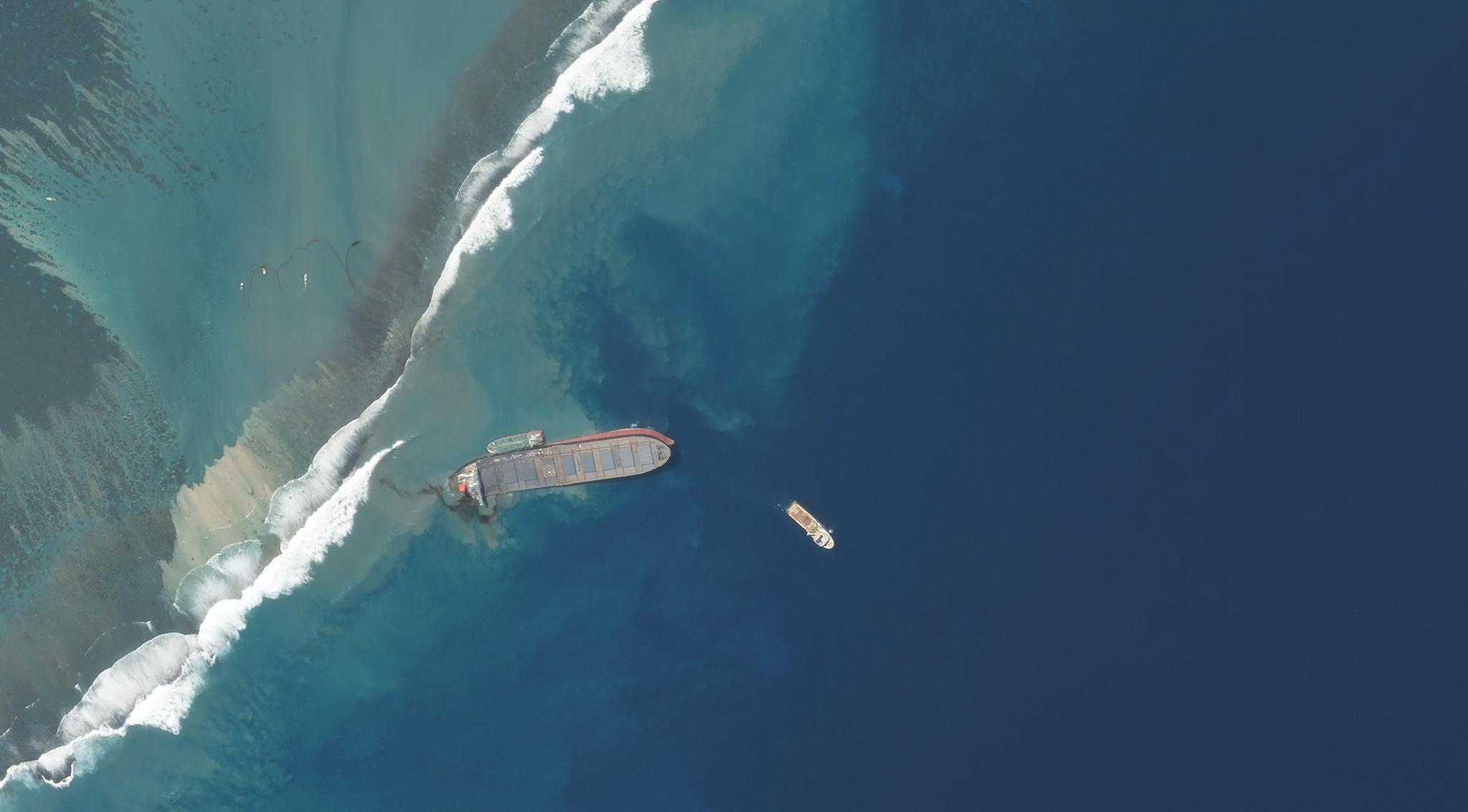
The MV Wakashio, a Japanese-owned ship, ran aground off the coast of Pointe d'Esny, Mauritius, and began leaking oil © 2020, Planet Labs Inc. All Rights Reserved.
AUTHOR PROFILE Andrew Zolli
Andrew Zolli is Chief Impact Officer at Planet.

Using Space to Help with the Mauritius Oil Spill

News

On July 25, 2020, the Japanese-owned bulk carrier MV Wakashio ran aground on a coral reef off the coast of Mauritius, spilling at least 1,000 tons of oil and endangering some of the world’s most pristine coral reefs and lagoons. Twenty-three days later, the spill continues to threaten the reefs, human well-being and livelihoods, and many rare species along the coast, engulfing UNESCO-designated marine parks and protected mangrove forests alike.

To aid in the ongoing response efforts, several organizations, including Planet, Vulcan Inc., (on behalf of the Allen Coral Atlas), Ursa Space Systems and ICEYE have come together to make significant amounts of geospatial data available, on an emergency basis, to relevant actors involved in ongoing clean-up efforts.

We believe this is the most comprehensive set of geospatial resources related to the spill available. These resources include:

  • Very-high-resolution (50cm/px) SkySat optical satellite imagery, courtesy of Planet, of the reefs around the southeastern coast of Mauritius, where the spill occurred, collected August 10-17, 2020.
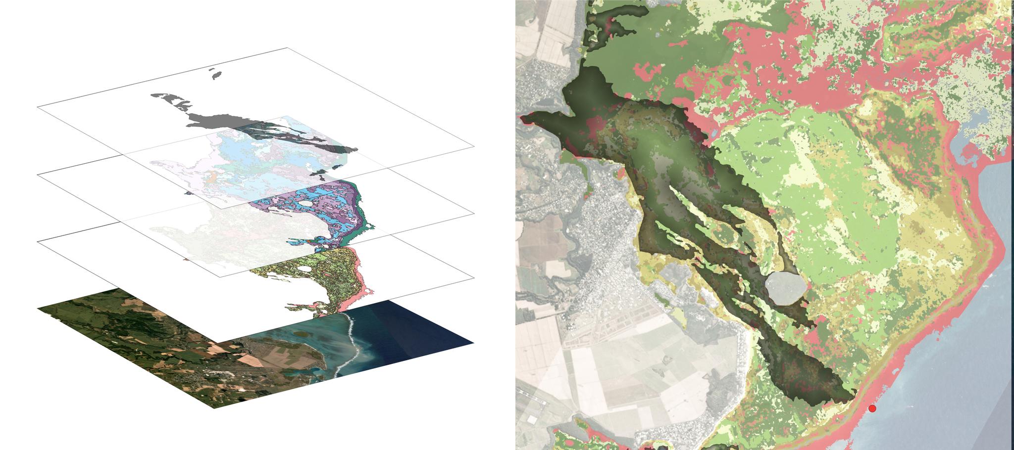
  • Benthic and geomorphic maps that characterize the shallow reefs in the same area in extensive detail. These were produced as part of the West Indian Ocean Region for the Allen Coral Atlas. Regional maps created are based on a mosaic of Planet’s PlanetScope sensor imagery (approximately 5m/pixel,) acquired over 2018-2020 and regional field observation collected in 2010-2020. More about the advantages and limitations of the Allen Coral Atlas dataset, and its benthic and geomorphic class descriptions, is available here and here.
  • Synthetic aperture radar (SAR) imagery, provided by ICEYE with analysis by Ursa Space Systems, which indicates the extent of the oil spill. This imagery is roughly 3m/pixel, and was collected from August 11-16, 2020.
Example data being made available in this release. On the left, separate data layers (from bottom) include Planet SkySat 50 cm optical satellite imagery; benthic and geomorphic imagery from the Allen Coral Atlas; and Synthetic Aperture Radar (SAR) imagery provided by ICEYE with analysis by Ursa Space Systems. On the right, a combined view. The red dot on the right is the original location of the MV Wakashio. SAR and Planet imagery used in this illustration are dated August 16, 2020.

Example data being made available in this release. On the left, separate data layers (from bottom) include Planet SkySat 50 cm optical satellite imagery; benthic and geomorphic imagery from the Allen Coral Atlas; and Synthetic Aperture Radar (SAR) imagery provided by ICEYE with analysis by Ursa Space Systems. On the right, a combined view. The red dot on the right is the original location of the MV Wakashio. SAR and Planet imagery used in this illustration are dated August 16, 2020.

How to Access:

To request access to this data repository, or for related matters, please contact mauritiusresponse@planet.com. In your email, please describe the organization requesting the data and the intended use.

Data Licensing:

Allen Coral Atlas maps, bathymetry and map statistics are © 2020 Allen Coral Atlas Partnership and Vulcan, Inc. and are licensed under the Creative Commons CC BY 4.0 license. This license allows for both the commercial and non-commercial use and sharing of this content, including the production of derivative works, as long as you give appropriate credit to its source, provide a link to the license and indicate if changes were made.

Planet Labs SkySat imagery is © 2020 Planet Inc. and is licensed under the Creative Commons CC BY NC 4.0 license. This license allows for the non-commercial use and sharing of this content, including the production of derivative works, as long as you give appropriate credit to its source, provide a link to the license and indicate if changes were made.


Map showing the location of Mauritius © 2020, Planet Labs Inc. All Rights Reserved.

Map showing the location of Mauritius © 2020, Planet Labs Inc. All Rights Reserved.

For additional information about the Allen Coral Atlas, please visit allencoralatlas.org. To learn more about Ursa Space Systems, please visit ursaspace.com or send an email to info@ursaspace.com. To learn more about Planet’s imagery solutions, please visit planet.com or if you’re a member of the press, press@planet.com. To learn more about ICEYE, please visit iceye.com or contact ICEYE online

We hope these resources will prove useful in response to the clean-up effort, and express our solidarity with the people of Mauritius.