
Here’s What Happened at COP26 and How Satellite Data Can Help
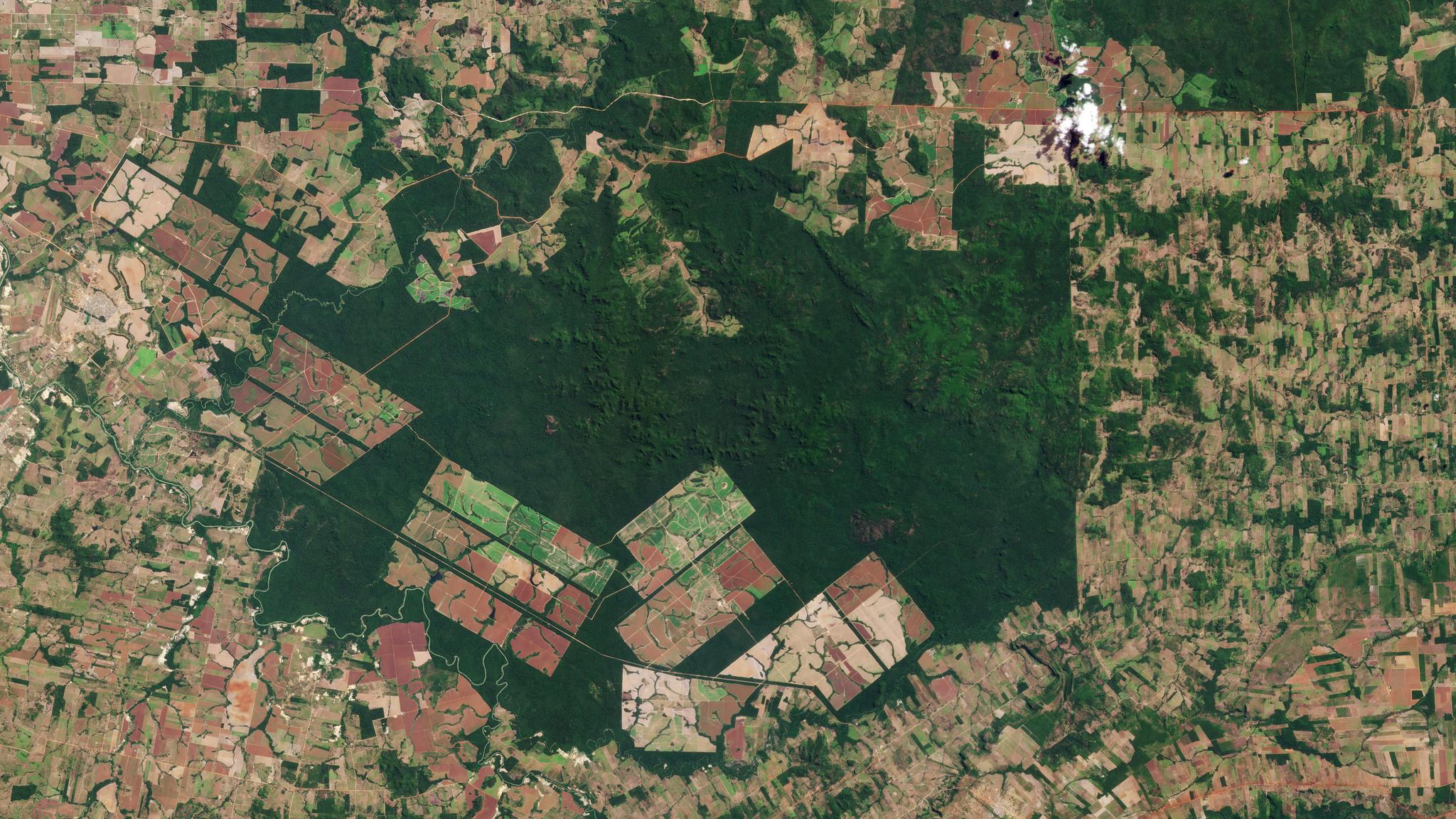
Daily PlanetScope data shows vast deforestation in Brazil. © 2021, Planet Labs Inc. All Rights Reserved.
StoriesCOP26 kicked off last week and already we’ve seen major pledges and initiatives announced that are designed to save our planet from the worst effects of the climate emergency. These critical plans for curbing emissions, ending deforestation, and protecting our oceans show promise, but in order to make meaningful progress there must be a measurement system in place - a way to track and report on targets and hold national governments and individual actors accountable. That’s where data and images from satellites can help. Planet’s satellite data captures a daily snapshot of every terrestrial and coastal location on Earth, and can provide an in-depth look into what’s happened in the past, our planet’s present state, and how we can improve our actions and reporting to guide decisions in the future. We stand ready and committed to helping nations and companies execute on these goals to protect our Planet and its ecosystems. Here’s a look at three major initiatives announced, and how Planet, alongside our many partners, can help. The Methane Pledge - Nearly 90 countries joined a U.S.- and EU-led effort to cut methane emissions 30% by 2030 from 2020 levels. Methane emissions are one of the leading causes of climate change, but we’ve historically lacked the data needed to identify the fastest and most effective ways to reduce them. Planet and its partners in Carbon Mapper are developing the technology to help the world meet this pledge. Soon, we will deploy a fleet of hyperspectral satellites - built by Planet and NASA JPL - to pinpoint, quantify, and track point-source methane and CO2 emissions. This data will greatly improve our understanding of and accelerate reductions in global methane (CH4) and carbon dioxide (CO2) emissions. Planet also provides data to Climate TRACE, a global coalition of scientific and technical organizations and NGOs, to track human-caused greenhouse gas emissions in real-time. Achieving the transition laid out in the Methane Pledge, will require independent, timely assessment of climate emissions to guide policy and ensure industries, governments, and organizations are held accountable for their progress, and Carbon Mapper and Climate TRACE are two key projects that can deliver the necessary data. The Forest Deal - More than 100 world leaders, representing more than 85% of the world’s forests, pledged to end and reverse deforestation by 2030. Deforestation is the second-largest source of greenhouse gas emissions and is largely driven by one common cause globally: economic development. Historically, we’ve had no practical way of accounting for forest value in economic decisions or transactions. This has incentivized developing countries to clear forests and convert the land to popular commodities like palm oil, soy, and cattle grazing for beef. This pledge sends an important signal to the commodities and finance sectors - we must put an end to the global economic incentives that say forests are not a valuable use of land. Daily, global satellite data can serve as a key tool in helping governments and corporations measure and manage their land-use risks in order to meet this ambitious goal. Norway is leading the charge in this area with the NICFI Satellite Data Program. This program provides free access to Planet’s high-resolution satellite data over the global tropics to support efforts to stop deforestation, promote sustainable land use, and reduce pressure on forests from global markets. The program is one year in and already we’ve seen over 9,000 users register for the data to help reduce and reverse tropical forest loss and combat climate change. The Oceans Pledge - More than a dozen countries pledged at COP26 to increase protection of their national waters in an effort to better regulate Earth’s climate. Scientists and activists have long argued that there is an inherent link between our waters and climate change, and this pledge commits these nations to fund greater investment in ocean-based renewable energy, decarbonization of industries, and further research initiatives. Our world’s oceans are home to the most important and diverse ecosystems on the planet, some of which are coral reefs and their linked coastal ecosystems, including carbon-rich seagrass meadows and mangroves. Through a pioneering partnership with Paul G. Allen Philanthropies and a consortium of renowned coral conservation and remote-sensing scientists, we recently launched the Allen Coral Atlas, the first-ever, high-resolution spatial and thematic detailed mapping of all the world’s tropical, shallow coral reefs. This dataset will allow conservationists, governments and local communities to plan more precisely, and effectively target conservation and restoration interventions for coral resilience and blue carbon initiatives related to coastal habitats. We’ve entered the most critical decade for climate action and the ambitious, and absolutely necessary, pledges being laid out at COP26 are a critical step towards aligning our world to take action. Planet’s core mission is to use space to help life on Earth and we stand ready with our data, platforms, and services to address the climate crisis.
Ready to Get Started
Connect with a member of our Sales team. We'll help you find the right products and pricing for your needs.