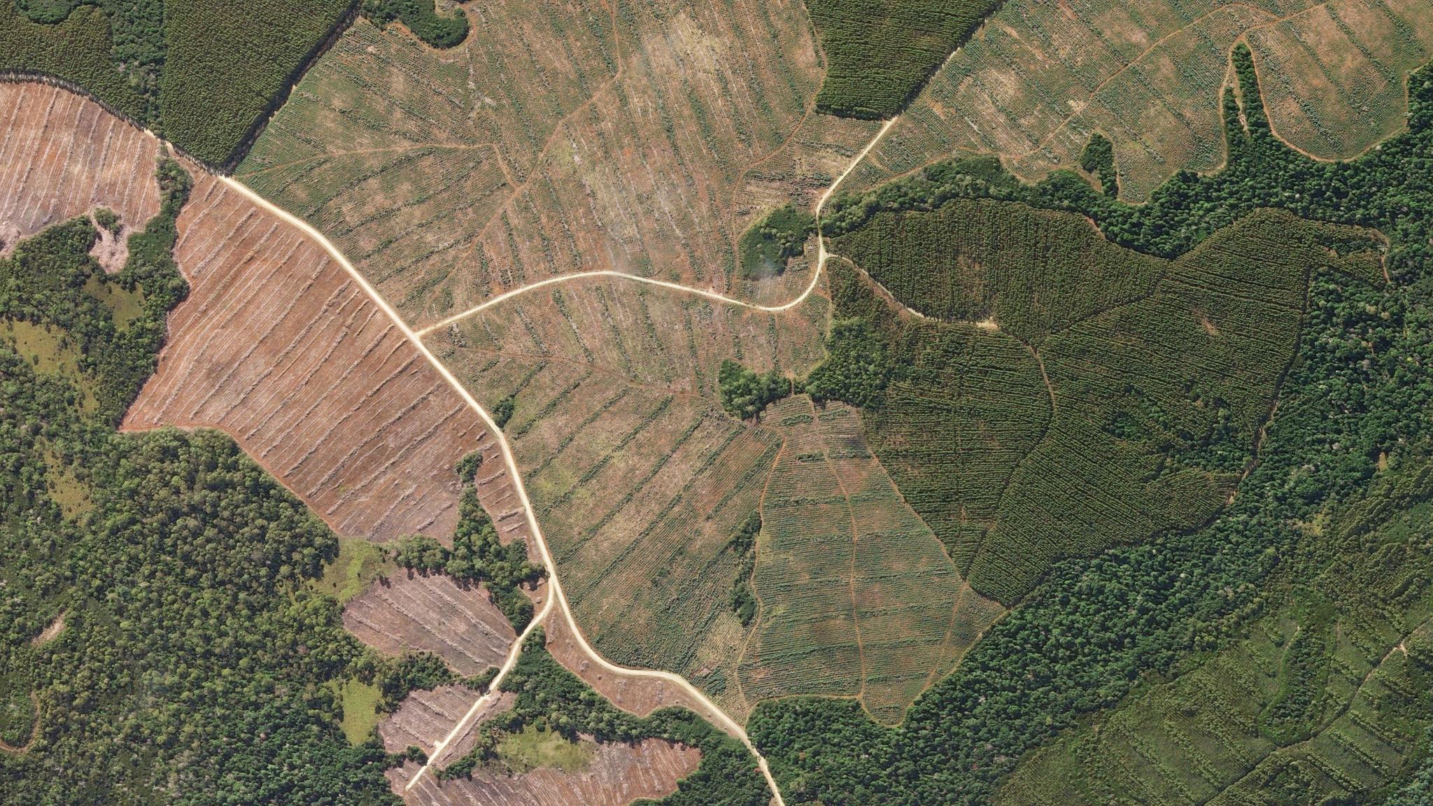
A SkySat captured this high-resolution view of timber stands at various stages of growth in the interior of Tasmania, Austrailia. © 2019, Planet Labs Inc. All Rights Reserved.
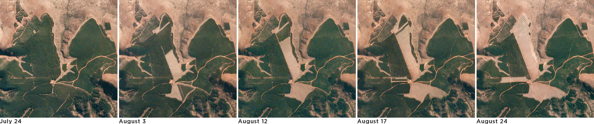
AUTHOR PROFILE Jenna Mukuno Senior Director of Product and Industry Marketing
Jenna oversees the teams responsible for helping our customers understand how Planet can help solve their challenges with daily Earth data and insights.

How Swift Geospatial is Creating Positive Change in Forest Management

Tech

Today is the International Day of Forests, created by the United Nations to help raise awareness about how forests can help humans generate environmental sustainability, create food security and produce thriving economies. Forests are also known for their carbon-capturing abilities and are one of our best defenses against the threat of climate change. Despite forests’ vital contributions to Earth, however, the world loses 18.7 million acres of forests every year, equivalent to 27 soccer fields every minute, due to varying causes, according to the World Wildlife Fund.

With that in mind, Planet partners with organizations like Swift Geospatial, a company based in South Africa that utilizes technology to optimize forest management and help reduce the unnecessary cutting of trees.

“Not many people realize how often trees are accidentally cut down that don’t need to be. It happens because forest managers need a better way to monitor cutting and stop mistakes before they happen,” says Michael Breetzke, co-founder and director of business development at Swift Geospatial. “Our technology and analyses paired with Planet’s data help forest managers make better decisions about smart, sustainable harvesting.”

When a forest manager hires a contractor to cut down a compartment or section of a forest, Breetzke explains, sometimes the contractor will cut down the wrong one, getting rid of much younger trees not ready for harvest, or the wrong species, leading to the unnecessary loss of trees and revenue.

Geospatial provides customers with weekly image comparisons to reflect forest changes. © 2019, Planet Labs Inc. All Rights Reserved.

Utilizing Planet’s frequent imagery, Swift Geospatial provides customers with weekly image comparisons to reflect forest changes. © 2019, Planet Labs Inc. All Rights Reserved.

Swift Geospatial uses Planet data in concert with other geospatial data and analytics software to create products for their clients that provide solutions to such problems. With Swift Geospatial’s platform, customers can see when a compartment was harvested, if a compartment was harvested on accident, or if certain species of trees within a compartment were harvested incorrectly. With the help of Planet’s daily imagery, forest managers can even catch accidental harvesting as it’s beginning and let a contractor know to stop cutting compartments before they’re ready to be harvested, reducing overall losses. They also tailor their platform to every client’s needs, so whether they are a geospatial expert or novice, they’re able to get the information they need.

“None of this would be possible without the partnership we have with Planet, which has been a reliable, repeatable data source for us,” says Jay Clark, head of sales at Swift Geospatial. “Planet has actionable information at a resolution and frequency we can use.”

Also, when proper harvesting is complete, Swift Geospatial’s platform can inform forest managers about when to task contractors to prepare a compartment for planting, getting trees back in the ground sooner. In addition, Swift Geospatial’s platform can inform managers immediately when a successful harvest is complete, so they can immediately pay the forester.

In addition to harvest monitoring, Swift Geospatial can monitor compartment/stand tree health as well as fire breaks within a compartment. They can help determine how many hectares have been affected by a fire, where the fire started and what compartments it moved into.

Near-infrared, red, green false-color composite of timber stands near Mtubatuba, South Africa. June 4, 2019. © 2019, Planet Labs Inc. All Rights Reserved.

Near-infrared, red, green false-color composite of timber stands near Mtubatuba, South Africa. June 4, 2019. © 2019, Planet Labs Inc. All Rights Reserved.

Going into the fire season, this can be especially helpful when determining whether fire breaks have been burned successfully. The analytics Swift Geospatial provides can give customers insights to help prevent disease or loss of timber.

“The system has been designed in a way that allows Swift Geospatial’s team to conduct post-fire analysis. This will assist end-user clients in knowing the total hectare loss. It also allows them to determine the origin of the fire for potential insurance claims,” says Breetzke.

Based in Pretoria, South Africa, Swift Geospatial currently provides support to forest managers in South Africa, eSwatini, Australia, New Zealand and Indonesia. They hope to expand further into Africa, Europe and North America in the coming months.

To learn more about how Swift Geospatial and Planet’s partnership can help create positive change in forestry, check out our webinar.