
Measuring global streamflow with Planet’s satellite imagery
Victoria Falls located on Zambezi River on the border of Zimbabwe and Zambia. © 2017, Planet Labs PBC. All Rights Reserved.
StoriesBlog article written by Stefanie Meier and Paula Fernández del Valle
Measuring streamflow in the world's rivers and streams is vital to managing water for people, nature, and commerce. This is particularly critical in times of major floods and droughts, when impacts on people, infrastructure, and the economy can be enormous. As climate change brings greater uncertainty and more frequent extreme events for hydro-climatic systems, the need for accurate and timely observations is of utmost importance.
Nick Everard, Senior Hydrometric Scientist at the UK Centre for Ecology & Hydrology (UKCEH) talked with Planet about how the measurement of river streamflow has been improved thanks to Planet’s satellite data and why the ESA Earthnet Programme plays an important role in this project.
Nick, thanks for your time and the interview. Before we dig deeper into the project, can you tell us a bit more about the UK Centre for Ecology & Hydrology (UKCEH)?
Nick: For sure! UKCEH has a long history of investigating, monitoring, and modeling environmental change. We are an independent, non-profit research institute with over 500 scientists, who manage environmental science across water, land, and air - not only in the UK and Europe, but across the world. For us, it is important that people and nature can prosper together. That’s why we seek to understand the environment, how it sustains life and the human impact on it. Our focus is on mitigating and building resilience to climate change. My colleagues and I provide the data and insights that researchers, businesses and governments need to create a productive, resilient and healthy environment. Here, our science makes a difference by informing policy-making, commercial innovation and conservation action all around the world.
A drone image taken of the Falls of Lora, Connel, in Scotland on a SkySat validation mission. Photo courtesy of UKCEH.
Wow, that sounds like you make a great difference for the environment with your daily work. How, specifically does this project make a difference?
Nick: Well, traditionally streamflow has been measured using instruments and infrastructure that are located in or on the water. Whilst generally effective, these methods rely on the presence of people, equipment and expertise at the time and place required for the observation. This is often difficult in nations with established monitoring networks and can be virtually impossible in regions with less well-developed river monitoring programs.
The cutting-edge research described here is supported by the ESA Earthnet Programme and complements the UKCEH-led FluViSat project funded by ESA’s EO4Society Programme. Whereas the FluViSat project uses Planet SkySat video imagery to measure river flow speed (and with great success, I might add!), the Earthnet project explores whether the same can be achieved using rapidly shot still imagery from the same satellites, but captured like a burst of pictures on a mobile phone.
Both projects are enabled by recent advances in non-contact river discharge monitoring methods that use high resolution digital imagery captured with aerial drones to determine the speed of movement of the water’s surface. As long as the movement of features advecting with the flow can be observed, and the cross-section of the flowing waterbody can be determined, the vital parameter of total discharge can be measured with a high degree of accuracy, with minimal infrastructure and a high degree of resilience. The method also has great potential in solving the longstanding problem of quantifying potentially damaging and hard-to-measure out of bank floodplain flows.
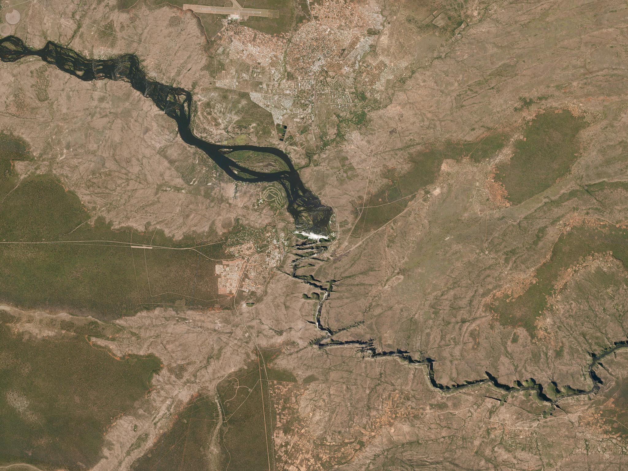
The Zambezi River, Batoka Gorge, Victoria Falls, located along the Zambia and Zimbabwe border with UKCEH’s processed water speed data. Photo courtesy of UKCEH.
The big advance for this project is that, by using Planet’s very high-resolution SkySat imagery, shot at a very high framerate, we can potentially determine the flow rates in medium and large rivers anywhere in the world. Besides measuring streamflow, the data also has the potential to highlight a range of drought impacts on the landscape. All this, without any people or equipment on site!
Here, UKCEH’s cutting edge science enables governments, businesses, and communities to better plan and be positioned for the future. It helps to improve the forecast of extreme weather events like floods and droughts but also the resilience.
So, this is the part where Planet’s satellite data comes into play?
Nick: Right! Our research will bring significant improvements in global capability to measure streamflow - how much water is flowing in the world’s rivers. Especially during times of flooding, accurate flow measurements are critically important, but can be difficult and potentially extremely dangerous to obtain. We live in a time where the importance of water and also the risks associated with it have never been greater. Nevertheless, many monitoring networks are inadequate, have deteriorated or have even fallen into disrepair. So, the question our team wanted to answer was, if we can measure flow with drones hovering over the water, what can we do from the high advantage point of the satellite?
We wanted to find out whether high-resolution SkySat data can enable a satellite-based monitoring surface velocimetry on a global scale in even the most remote of locations. We found out that you collaborate with ESA on the ESA Earthnet Programme, where Planet’s imagery is available to the Earth Observation community for non-commercial use.
How has that benefited you in your day-to-day work?
Nick: For me, it was already impressive to see that we could measure the water speed just by observing the river’s surface, but we also see the potential of Planet’s SkySat all frames data that enables us to map water velocity. The most incredible example of success we have had is in the Zambezi River. We managed to produce a map of water speed for 1 km of the river, which was previously pretty much impossible, given the inaccessibility of the river in a deep gorge, and very fast flowing rapids. It would have required intensive field work with multiple deployments of the drone. The very high resolution and rapid frame rate of the SkySat constellation is what enables us to track the river's flow, and to our knowledge, we are the only team that has achieved something like this!
There are many areas of the world where even major rivers are barely monitored, so it is very exciting to bring remote sensing to locations such as the Nile and Congo rivers in Africa, for example. But we have also demonstrated the technique much closer to home, with a test site at the Falls of Lora in the Highlands of Scotland, where we have successfully measured the strong tidal currents that flow in and out of Loch Etive twice a day.
With Planet’s SkySat constellation, we get the capability of multiple daily revisits, providing multiple observations. To measure river flow from space. I never imagined that this would be possible even five years ago!
The Falls of Lora, Connel, in Scotland with UKCEH’s processed water speed data. Photo courtesy of UKCEH.
Anything you would like to add?
Nick: In my career as a scientist, I have previously used publicly available satellite data, but with the Earthnet Programme providing access to the high-resolution data of a commercial provider, like Planet, this has really made an impact on my research. I am looking forward to bringing the whole project forward and seeing the results it will bring, not only for flooding and droughts, but also for global water management. In the future, an absolute killer feature would be to quickly get the river depths from space without any further support. Again, we are really happy and excited with what we achieved, but we are even more excited with what the next generation of satellites may enable us to achieve in the future!
For more on the FluViSat work, explore these resources:
FluViSat on ESA's projects page
FluViSat page on UKCEH
FluViSat video on UKCEH
FluViSat blog on UKCEH
Ready to Get Started
Connect with a member of our Sales team. We'll help you find the right products and pricing for your needs.