
Early Warning Systems: Monitoring the Oder River with EOMAP
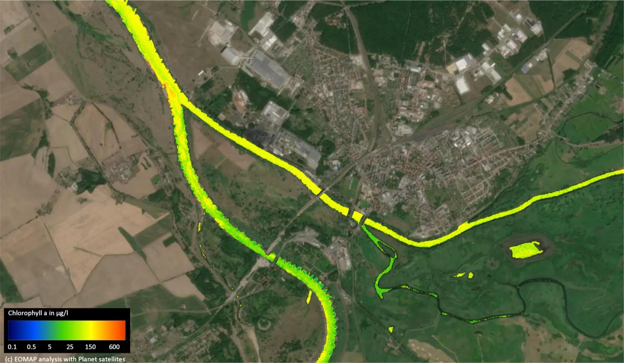
"The image shows the inflow of the Warthe (right) at August 3 2022, carrying markedly higher algae concentrations increasing the algal level in the Oder below significantly." EOMAP analysis over Planet satellite data. Image credit: EOMAP
StoriesIn August 2022, news around the world reported on a mysterious environmental catastrophe which impacted the Oder River in Germany and Poland. Thousands of dead fish were found washed up along the river’s banks. Puzzling scientists and government officials across Europe, this disaster caused analysts to launch robust investigations. Using Planet satellite data, EOMAP, a water quality monitoring organization, took a deep dive into the ecological events that led to to die-off in August. Their analysis revealed which compounded environmental factors led to the creation of a toxic algal bloom, lethal to fish and other aquatic organisms.
The mystery was solved.
But as we approach this summer, a question remains. What if all of this was to happen again?
Planet satellite data can be leveraged by governments and analysts around the world to create early warning systems for these types of events. Due to climate change and the severe weather conditions bringing drought and intense heat, extreme situations such as low water levels and high water temperatures are occurring more and more frequently in rivers. With our data, EOMAP has continued to monitor the Oder River over this last year.
What are they seeing?
Conditions favoring the algae bloom last summer are looking similar this summer: Temperatures are high; solar radiation has increased; water levels and discharge are similar to last year; and significant levels of chlorophyll have been spotted. This preliminary data could be critical. Insights gleaned from satellite data can provide an early cue for governments and organizations who could help prevent the disaster from repeating itself.
To learn about EOMAP’s analysis and findings in full, read their article, cross-posted below (translated from German):
Déjà-vu on the Oder – ensuring water quality on rivers
Are there more environmental disasters like the one on the Oder in 2022? And how can they be foreseen or avoided in the future? To do this, EOMAP continuously analyzes the course of the river using satellite data. Critical developments in rivers can be identified at an early stage and discharges can be adjusted at the click of a mouse. But only a few authorities use the online solution.
Since the fish die-off in the Oder in August 2022, EOMAP has been continuously analyzing the water quality, from Poland to the estuary in Germany. Because satellite data can be used to show early on whether such a harmful algal bloom will develop again. To do this, the data analysts compare the following drivers for algae growth from last summer with this summer over the course of the river: water level and discharge, solar radiation and surface temperature, as well as the algae pigment chlorophyll-a.
"All in all, we see that in 2023 a similar development is emerging at certain points on the Oder," reports Dr. Thomas Heege, Managing Director of EOMAP.
In May 2023, the chlorophyll values on the Oder near Gliwice reached peaks similar to those in summer 2022 (when the fish were dying).
In April and May 2023, for example, the Gliwice Canal already had chlorophyll values in the highest range of the previous year, and the Czernica reservoir northwest of Ratovice showed a clearly visible algae bloom (over 100 µg/l) at the end of May. This was preceded by days of increased solar radiation. At the beginning of June, the water level in the central Oder area (river km 300 - 400) was higher than in July 2022. However, very low discharge values were measured at the same time in the south (river km 220) and on the German side in the north. Comparable to the course in summer 2022, the discharge on the German side and south of Wroclaw also decreased. On the Polish side, from the beginning of May until mid-June, the water flow was comparable to that in 2022. The rise in temperature of the water surface in the Gliwice Canal was also clearly visible in the course of May 2023.
"Now things have calmed down a bit. But with the current increase in solar radiation and rising temperatures, this mix could again lead to strong algae growth and toxic conditions," says Heege.
With EOMAP, all hydrological and water-biological data flow into an online solution for a reliable overview with just a few mouse clicks. If you set threshold values for critical parameters on this "eoApp", the data mix becomes an early warning system. This means that unfavorable conditions, for example for strong algae growth, can be identified at an early stage. Authorities could, for example, pinpoint where and when saline industrial waste water should be avoided in order to prevent the growth of toxic golden algae. Environment Minister Lemke called for the latter at the Oder Conference on June 6th. The "eoApp" is not only suitable for rivers, but also for lakes.
"Many international, but only a few German authorities have recognized the potential and are using satellite data to keep an eye on bodies of water. But we think that there will soon be more," hopes Karin Schenk, Head of Water Quality at EOMAP.
For its comparisons, the Bavarian medium-sized company, which emerged from DLR in 2006, uses European Sentinel data from ESA and mostly high-resolution PlanetScope data, which are supplied by Planet's Dove satellites. For the investigations on the Oder, EOMAP also works closely with the "Water Resources and Environment" department at the Helmholtz Center for Environmental Research (UFZ).
In contrast to on-site water samples, satellite data allow a synoptic view of the entire course of the river. They also trace critical developments long after the water has drained away. Thanks to the high spatial and temporal resolution - like that of Planet's satellite data - smaller tributaries and reservoirs can also be analyzed.
Ready to Get Started
Connect with a member of our Sales team. We'll help you find the right products and pricing for your needs.