
From banks to bunds: how Africans are harnessing satellite data to financially derisk pastoral livelihoods
By: Njeri Maina and Megan Zaroda
Although Africa as a whole has contributed the least to greenhouse gas emissions, no continent has been more affected by climate change-induced natural disasters like flooding and droughts. And since Africa is home to a third of the world’s natural resources and 70% of its population is dependent on agriculture for their livelihoods, this underscores the importance of water management in times of scarcity, sustainable land use planning as the region develops, and the need to economically shore up pastoralists in lean seasons.
And a handful of local groups are doing just that. Academics, farmers and bankers alike are applying local ingenuity to geospatial data to not just explore solutions – but deliver results.
Drought Insurance for Farmers
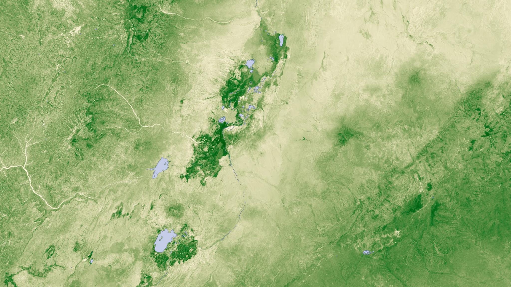
Especially for sub-Saharan African grasslands, drought is a persistent threat to economies and livelihoods. Regional reinsurance company, ZEP-RE, is implementing a drought risk protection program known as DRIVE. This is a World Bank-funded project in partnership with the Governments of Djibouti, Ethiopia, Kenya and Somalia to support the financial derisking of pastoral livelihoods and include them in livestock value chains in the Horn of Africa (HOA). ZEP-RE is using satellite data insights to expand its insurance program to support over 250,000 pastoralists.
How does that work? To assist, Planet is delivering analysis-ready Basemaps with Normalized Difference Vegetation Index (NDVI) time series data to help ZEP-RE measure vegetation health for an area of more than 600,000 km2 of Eastern Africa. The reinsurance company will also utilize Planet data as their independent calculation agent to quantify conditions and provide metrics to measure drought. ZEP-RE is then looking to generate a drought index that can be customized to locations to determine payout amounts, generate premium rates, and enable faster claims. These insights are key to helping them scale their risk calculation capabilities.
Similarly, ACRE Africa, which is one of the largest micro-insurance providers in Africa, is working with multiple partners to support the Kenyan Ministry of Agriculture, Livestock and Fisheries (MoALF) to implement new tools for climate risk insurance. For example, they are using Planetary Variables solutions like soil moisture index and a picture-based loss verification tool to (1) minimize the cost of verifying the loss itself, (2) make crop insurance more attractive and accessible to smallholder farmers and (3) help smallholder farmers reduce future losses due to drought by offering advisory services to farmers, including both climate smart agriculture practices and weather-related decision support.
And while these two commercial projects demonstrate the scalability of satellite-based agricultural programs as they expand from Kenya through East Africa, scientists, too, are exploring new methods to use near-daily monitoring of fields through our Education and Research Program. Researchers are using PlanetScope to identify livestock enclosures in Kenyato support research in soil health and greenhouse gas emissions and others are using Basemaps to remotely evaluate the differences between drought- and locust-caused vegetation damage in Ethiopia.
Climate mitigation and adaptation
Given how often drought strikes, Dutch land restoration nonprofit Justdiggit turned to nature-based solutions rooted in ancient practices. In Kenya and Tanzania, they’re working with local farmers to dig bunds — semi-circular shaped pits that help the soil capture rainwater – in order to hydrate and regreen parched land.
You may not be able to see every drop from space, but cumulatively, that captured water added up. Based on two of Justdiggit’s bund sites, the total extra retention of water as measured by the Soil Water Content data can be estimated to equal approximately 790,000 liters over less than 4 years. Assuming a person drinks 3 liters of water per day, the average additional daily retention would be sufficient to supply 191 people with water to drink.
How were they able to make those calculations? Justdiggt is using a full suite of Planet’s satellite products to quantify, evaluate, and scale the regenerative practice over time:
- PlanetScope’s imagery scan helps them to evaluate discrete change over time in the bunds.
- The Planetary Variables metrics quantified soil water content and land surface temperature, enabling Justdiggit to evaluate how many liters of water were retained by the soil, how many degrees the surface cooled down, and how much vegetation increased since the bunds were dug.
- Lastly, the team tasked SkySat satellites to view the overall scale of their regreening efforts overtime.
Marrying modern technology with nature know-how is also an important element of work for projects that will be focused on early warning systems and climate adaptation – the process of adjusting to current or expected effects of climate change – spinning out of Microsoft’s first global expansion of the AI for Good Lab, in Nairobi, Kenya and Cairo, Egypt. Leveraging Planet’s satellite data, Microsoft’s AI, and a coalition of African partners that Microsoft is establishing, the goal is to facilitate ways to generate additional climate data and drive continued research.
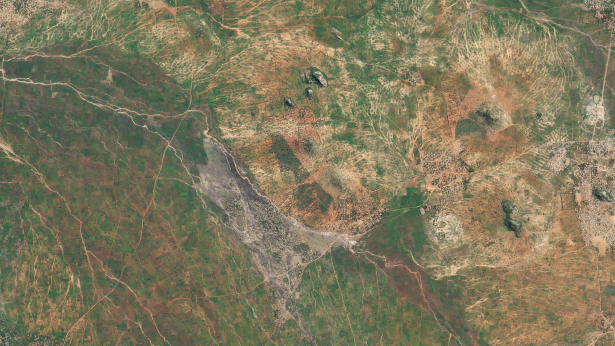
PlanetScope image of Justdiggit restoration site in Pembamoto, Tanzania captured May 11, 2022. © 2022, Planet Labs PBC. All Rights Reserved.
Natural resources and energy sources
Just like with the bund project, the ability to view change over time is a critical aspect to managing natural resources – from the water we need to the water we don’t; to the land we use and the land we abuse.
For example, as areas of the Congo rapidly embrace development, the Central African Forest Initiative is bringing together the six Congo Basin countries and multilateral donors to conduct regular technical training to increase adoption of high-res monitoring to watch and predict the impact to the area’s forests. Similarly, the National Sustainable Development Fund of Mozambique is using Planet Scenes data to validate deforestation events and improve forest area change estimation and mapping.
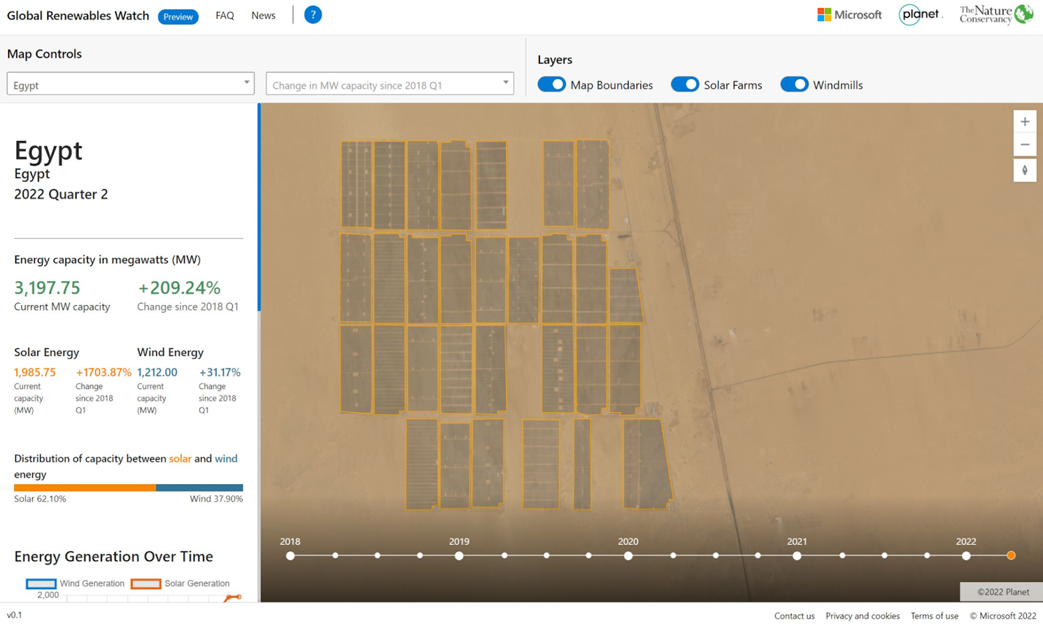
Gaining a greater understanding of land use is a key question the Global Renewables Watch is seeking to answer. Starting by mapping Kenya and Egypt, the Microsoft x The Nature Conservancy x Planet mashup is a first-of-its-kind living atlas intended to map and measure all utility-scale solar and wind installations on Earth using AI and satellite imagery, allowing users to evaluate clean energy transition progress and track trends over time. The noble ambitions of adding clean energy to the grid can sometimes come at a cost as solar or wind farms are built on top of arable farmland or wildlife ecosystems. So GRW reports out on two factors: energy capacity and output, but also how the land itself has changed, so that those using the tool can potentially pivot their siting strategies to be more complementary to both energy generation and ecosystem sustainability.
Here’s What It Takes
The common thread through all of these examples is collaboration. “Public-private partnerships are an essential tool for the success of climate change projects in Africa,” said Njeri Maina, Planet’s Market Development Director, Africa. “Opportunity lies at the confluence of bringing together (1) applying proven use cases that can be (2) augmented and scaled with local ingenuity and understanding of challenges that are (3) catalyzed by public-private partnerships and collaborations.”
Forward-looking Statements
Except for the historical information contained herein, the matters set forth in this blog are forward-looking statements within the meaning of the "safe harbor" provisions of the Private Securities Litigation Reform Act of 1995, including, but not limited to, the Company’s ability to capture market opportunity and realize any of the potential benefits from current or future product enhancements, new products, or strategic partnerships and customer collaborations. Forward-looking statements are based on the Company’s management’s beliefs, as well as assumptions made by, and information currently available to them. Because such statements are based on expectations as to future events and results and are not statements of fact, actual results may differ materially from those projected. Factors which may cause actual results to differ materially from current expectations include, but are not limited to the risk factors and other disclosures about the Company and its business included in the Company's periodic reports, proxy statements, and other disclosure materials filed from time to time with the Securities and Exchange Commission (SEC) which are available online at www.sec.gov, and on the Company's website at www.planet.com. All forward-looking statements reflect the Company’s beliefs and assumptions only as of the date such statements are made. The Company undertakes no obligation to update forward-looking statements to reflect future events or circumstances.
Ready to Get Started
Connect with a member of our Sales team. We'll help you find the right products and pricing for your needs.