
Seeing African Restoration from Space: Planet and Justdiggit Enable Nature-based Solutions to Regreen the Land
PlanetScope image of Justdiggit restoration site in Pembamoto, Tanzania captured May 11, 2022. © 2022, Planet Labs PBC. All Rights Reserved.
StoriesPlanet Images and Graphics by: Max Borrmann and Rob Simmon with support from Owen Troy, Steve Levay, and Mendy Van Der Vliet.
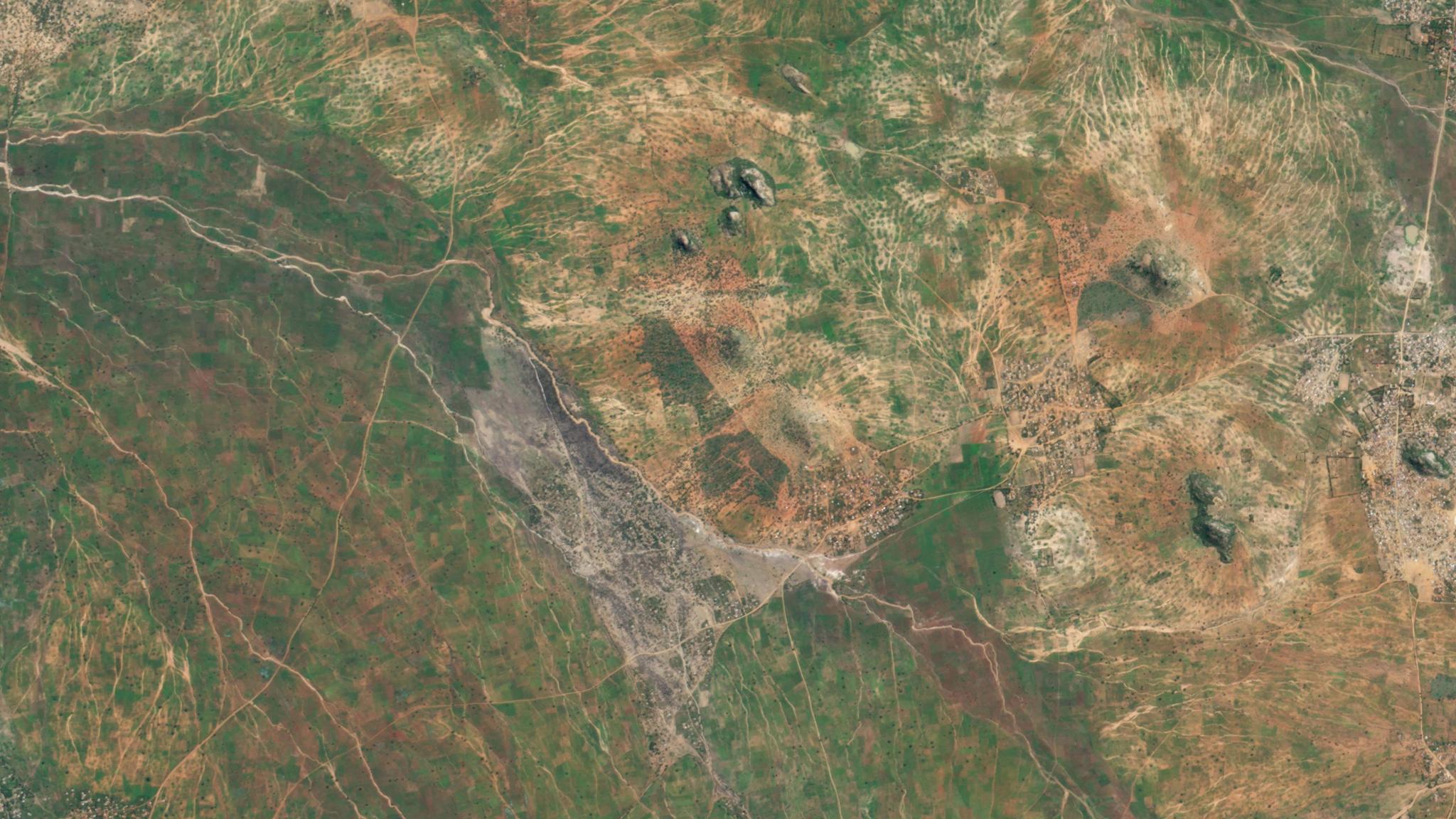
As our satellites pass over regions of Kenya and Tanzania, they are capturing a tremendous transformation happening on the ground. Land that has been dry and parched for years is now sprouting green grasses and young trees. Rainwater is reviving the land and supporting restored and thriving African native ecosystems. This metamorphosis is the impact of collaborative efforts between local pastoral communities and Justdiggit, a nonprofit dedicated to supporting land restoration through nature-based solutions. And using our satellite data, including SkySat, PlanetScope, and Planetary Variables, Justdiggit quantifies, evaluates, and scales these transformative projects with tangible metrics.
Aptly named, Justdiggit supports local farmers and pastoralists in Tanzania and Kenya to use accessible tools, like shovels, to dig bunds—semi-circular shaped pits that help the soil capture rainwater. In regions impacted by drought and loss of natural vegetation, the top layer of soil can harden and act as a seal, but by digging through the dry layer, rain water can trickle down and hydrate the parched land. This ancient regenerative practice cools down the temperature of the region by allowing native grasses and trees to grow back, and this landscape change can be captured by Planet’s satellite imagery. Justdiggit uses mobile technology, data, and communication to scale up their impact on the African continent and to create awareness around nature-based solutions world-wide.
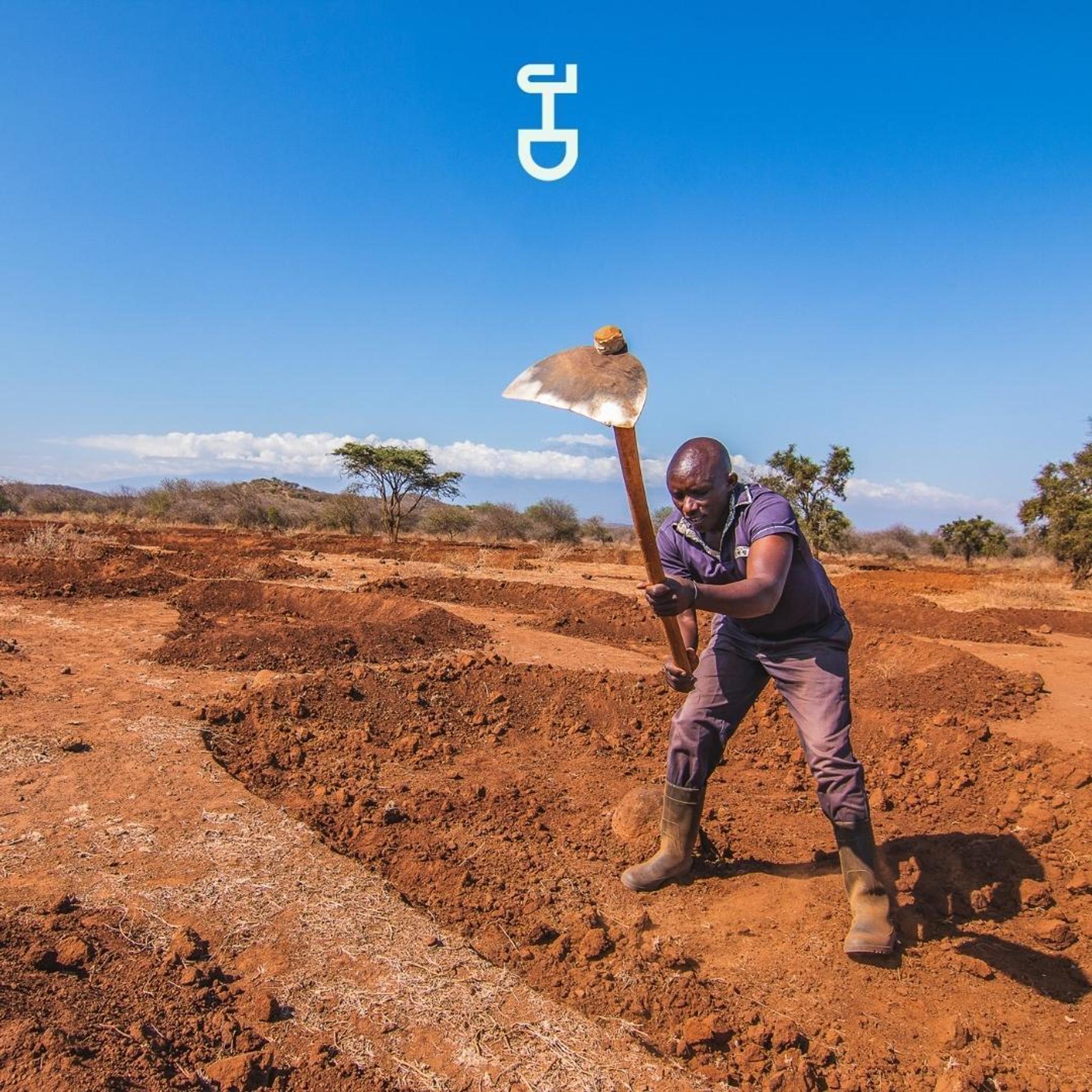
A Kenyan community member works in collaboration with Justdiggit to create bunds in the earth that can capture rainwater and restore the land. Image courtesy of Justdiggit.
“Building the futures we want will require us to live not only sustainably, but restoratively,” said Andrew Zolli, Chief Impact Officer at Planet. “The surest path to doing so is to support culturally relevant and ecologically proven practices with new tools, and that’s exactly what’s happening here. We couldn’t be prouder to see our data, products and services used in this way.”
With 300,000 hectares under regreening, Justdiggit and their partners have already brought back over 10 million trees in sub-Saharan Africa. Over the last year, Planet, the European Space Agency (ESA), the University of Leicester, and Justdiggit launched the Restore-IT project, focused on evaluating and quantifying the success of their regreening initiatives. In this project, Justdiggit leveraged our PlanetScope and Planetary Variables products to measure the impact of their restoration projects in Tanzania and Kenya.
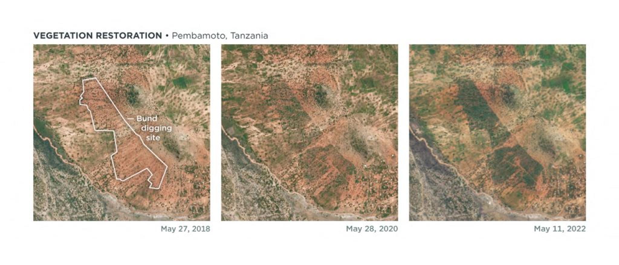
PlanetScope imagery from May 27, 2018 through May 11, 2022 captured Justdiggit’s vegetation restoration in Pembamato, Tanzania. The site of the bunds can be seen outlined in white in 2018. This region shows a dramatic change in vegetation growth in the following years thanks to the creation of the bunds. © 2022, Planet Labs PBC. All Rights Reserved.
Through PlanetScope’s imagery scan, captured at 3 meter resolution, Justdiggit received high temporal resolution data of their sites, helping to evaluate discrete change over time. The Planetary Variables metrics quantified soil water content and land surface temperature, enabling Justdiggit to evaluate how many liters of water were retained by the soil, how many degrees the surface cooled down, and how much vegetation increased since the bunds were dug. Beyond this project, Justdiggit is also tasking our high-resolution SkySat satellites which allow them to view the scale of their regreening efforts overtime, visualizing the landscape change at 50 cm resolution.
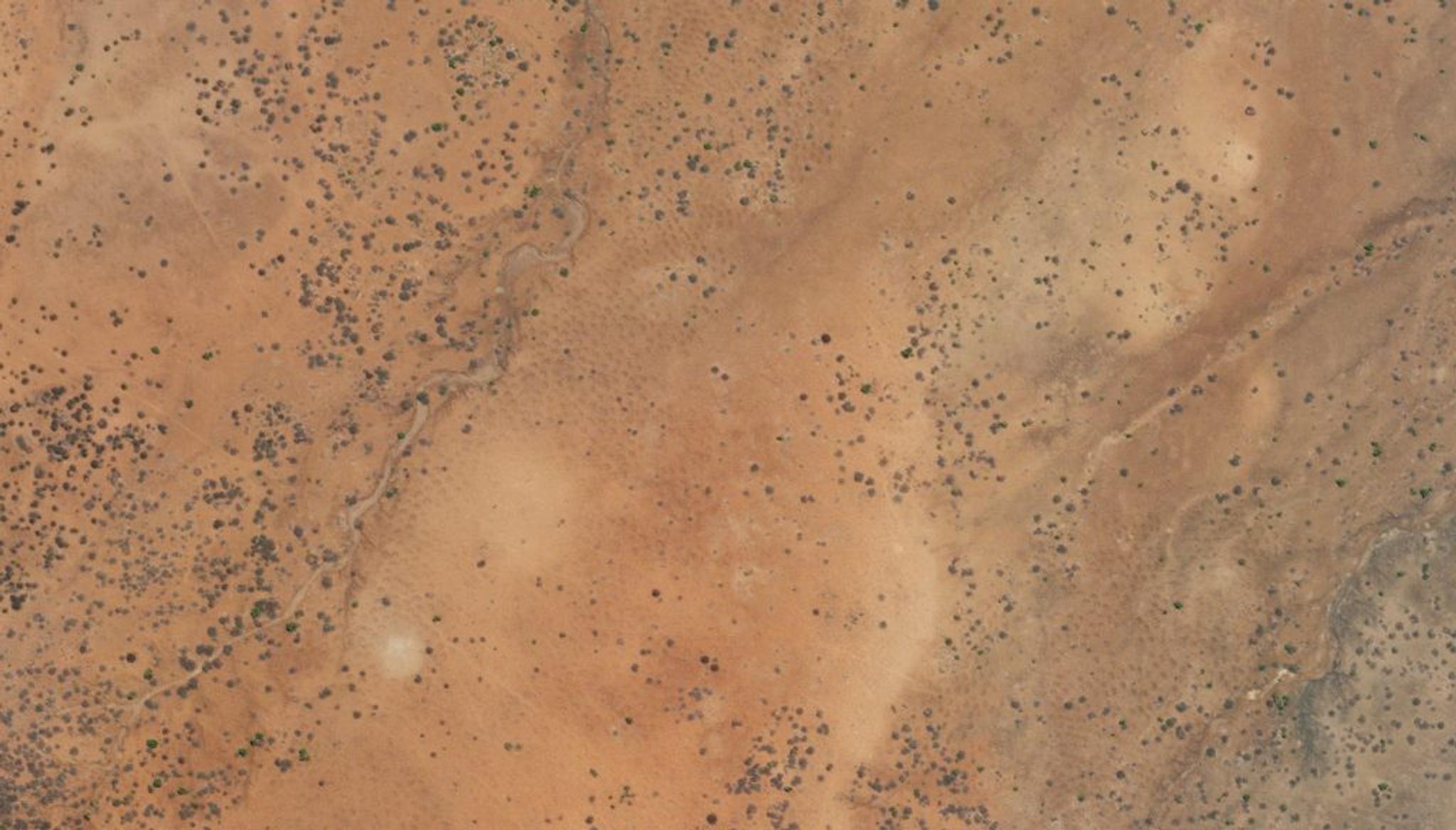
Planet SkySat image of Justdiggit’s Kenyan restoration site taken September 19, 2022. Small bunds can be seen dug into the soil near the center of the image. © 2022, Planet Labs PBC. All Rights Reserved.
Tanzanian community members dig large bunds in Pembamoto, Tanzania with the support of Justdiggit. Video courtesy of Justdiggit.
“The key is in showing the impact long term and at the landscape level,” said Sander de Haas, Chief Technical Officer and Regreening Expert at Justdiggit, explaining that Planet data was used throughout the restoration process — from planning to evaluation — and provided valuable data for reporting comprehensive metrics to donors and partners.
“I focus on site selection, trying to identify from a remote sensing analysis which sites are suitable for our types of interventions. By having access to SkySat data, we are able to task imagery of the site. If indeed, this is an interesting site, we then send out a team to check on the situation on the ground, take samples, and talk to the community,” continued de Haas. After building long-term relationships and partnerships in the region, Justdiggit spearheads landscape restoration efforts and community education.
On the ground, pastoralists live with their livestock while wildlife, like zebras and gazelles, graze on the newly sprouting grasses from the bunds. Our SkySat imagery captures the scale of the landscape regreening over months, while our Planetary Variables datasets help evaluate where regions are having success—lending scientific insights for the improvement of future projects.
“While the impact of our projects is obvious if you walk through the tall grasses in an area which was barren before, it is hard to capture that impact into quantifiable impact metrics that people can relate to,” said de Haas. “Using Planetary Variables, we are able to do exactly that: show the impact of our projects in tangible numbers such as ‘liters of water retained’, ‘degrees cooling’ and changes in biomass. This adds another dimension to our impact monitoring.”
Using the Planetary Variables datasets, Justdiggit and Planet have been able to observe clear indications of restoration effects in land surface temperature and soil water content when comparing their Pembamoto West bunds site in Tanzania to the average of their “control” sites where no interventions took place:
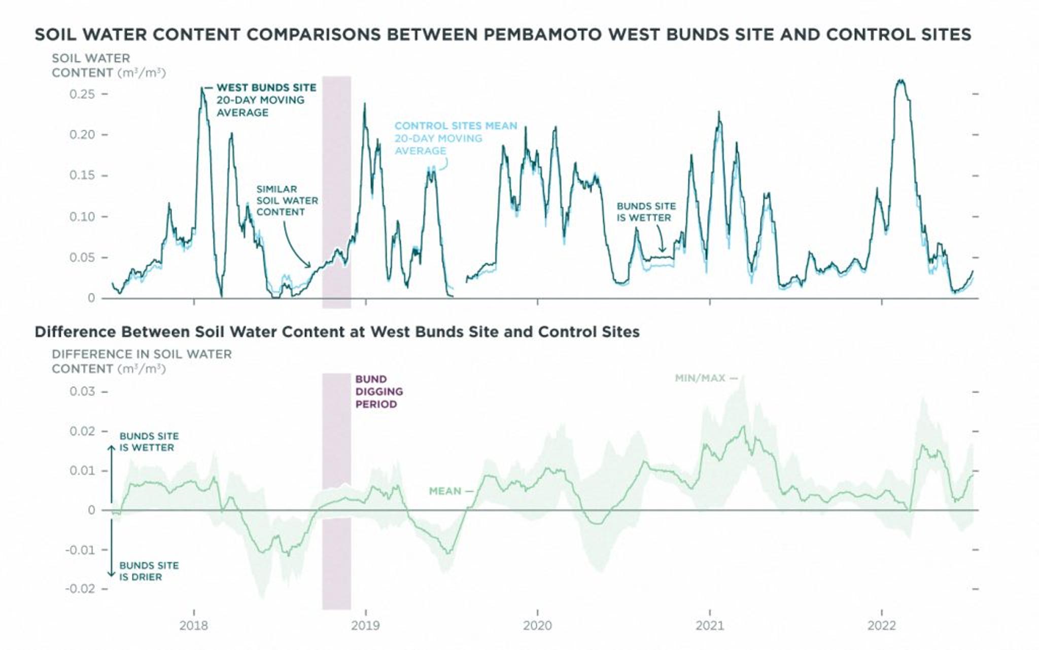
The top graph visualizes the average soil water content of the Pembamoto West Bunds site (dark green) and the mean of the nearby control sites (light blue) over time, indicating that the bunds helped retain more water in the soil over the years. The bottom graph shows the difference in soil water content over the years, showing that the bunds area is almost always wetter after the digging of the semi-circles, indicating an increased retention of water by the soil in time.
Based on two of Justdiggit’s bund sites, the total extra retention of water as measured by the Soil Water Content data can be estimated to equal approximately 790,000 liters over less than 4 years. This satellite-based analysis captures data from the top 10 centimeters of the soil, therefore the number is a conservative estimate as the increased retention is expected over a deeper soil layer (i.e. over the total grass root depth). Assuming a person drinks 3 liters of water per day, the average additional daily retention would be sufficient to supply 191 people with water to drink.
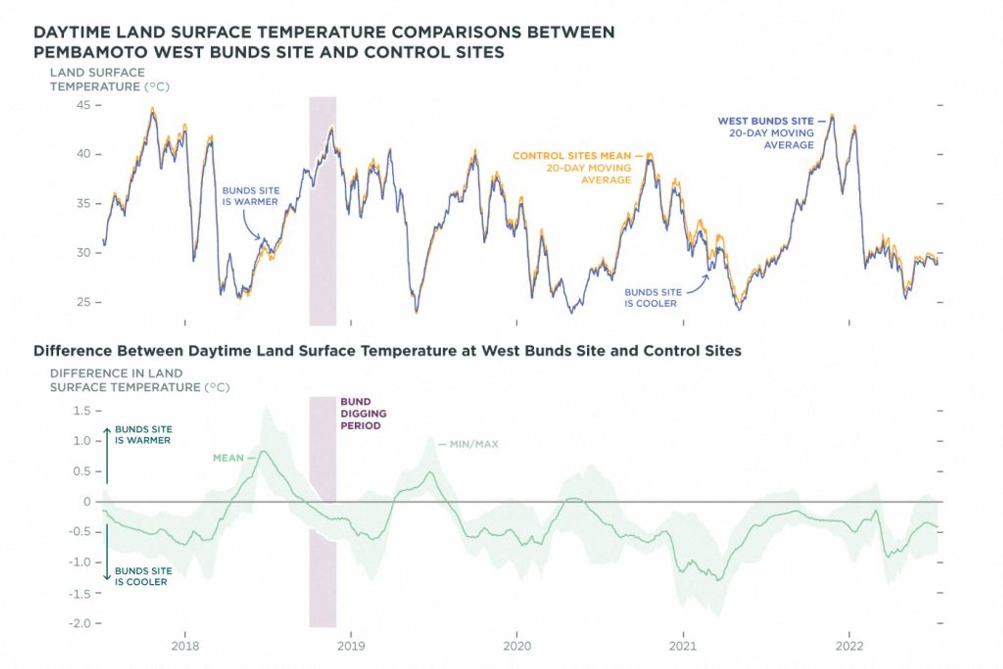
The top graph visualizes the daytime land surface temperature of the Pembamoto West Bunds site (blue) and the mean of the control sites (orange) over time, highlighting how the West Bunds site’s average temperature mainly remains below the control average temperature following the creation of the bunds. The bottom graph indicates that the bunds have cooled down the top soil up to 0.75 degrees Celsius, depending on seasonal vegetation patterns.
"This proves that landscape restoration can have a significant contribution in mitigating the effects of climate change," said de Haas. With information highlighting these effects, Justdiggit is able to further scale their grassroots restoration work. By capturing tangible numbers, they can show key stakeholders like funders their progress. Likewise, as one local farming community is able to understand the impact of their work, they then become leaders and teachers for the next community, spreading educational roots through the region and growing new programs. “Thanks to the generated income through regreening, I can now bring my kids to school,” said Mpachacha Isayta, a pastoralist living in Kuku, Kenya working with Justdiggit.
These datasets and our satellite images show the tangible progress that these initiatives are having on the landscape of Kenya and Tanzania, and this is just the beginning. As Justdiggit aims to scale their program to millions of farmers, they and their partners are making significant strides to regreen Africa, support sustainable livelihoods, and combat the climate crisis. Working together, we both aim to show that solutions do exist, and you can even see them changing the world from space.
Want to hear more about our work with Justdiggit? Read their peer-reviewed scientific paper, and listen to our interview with Sander De Haas below:
Ready to Get Started
Connect with a member of our Sales team. We'll help you find the right products and pricing for your needs.