
Getting to Ground-Truth in Asia - Part Four: What’s ahead for the Earth Observation industry in Asia
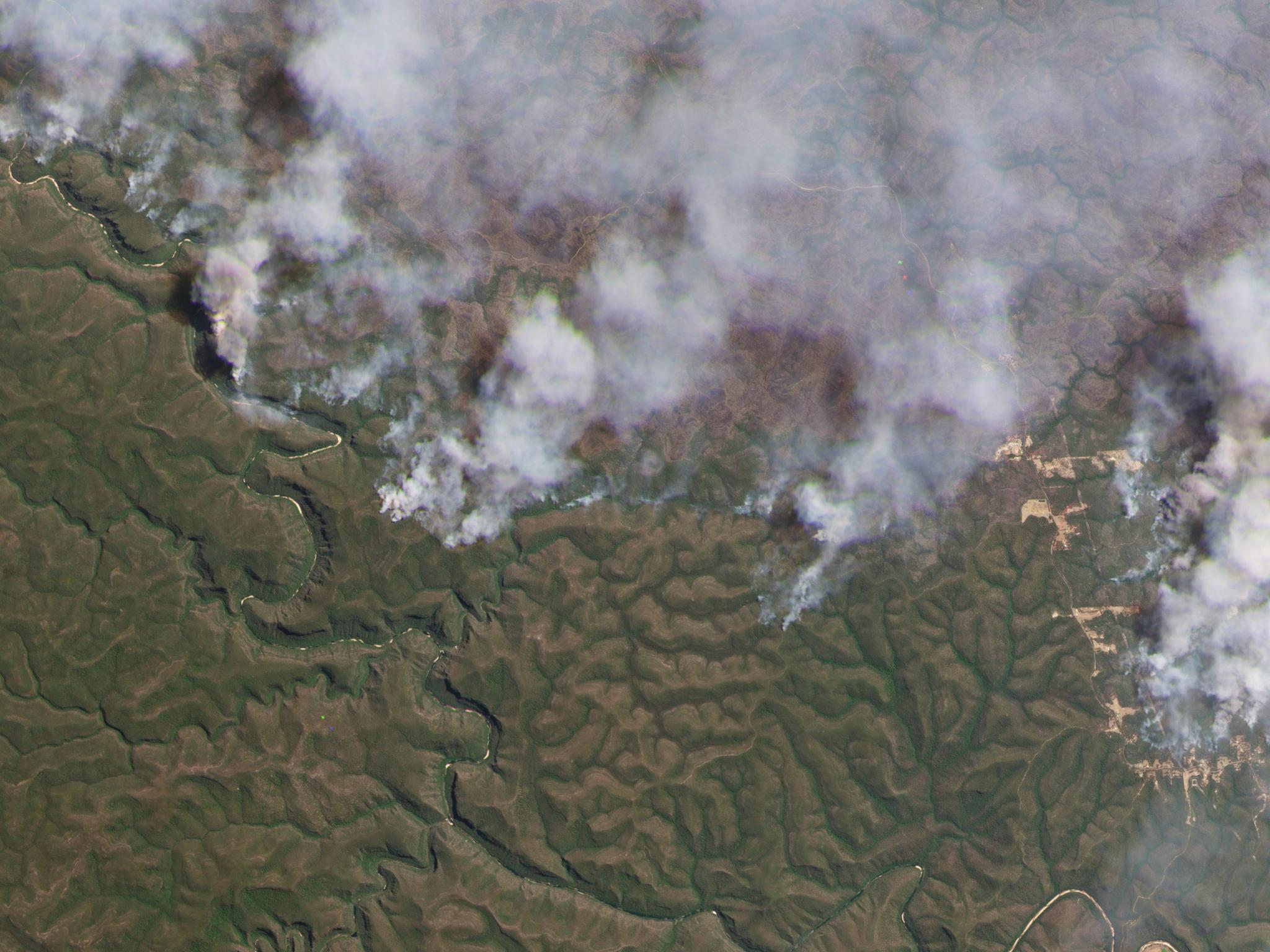
PlanetScope image of wildfires in the Blue Mountains, Australia taken November 18, 2019. © 2019, Planet Labs PBC. All Rights Reserved.
StoriesA conversation with Ben Allard
While we’ve explored a number of industries in which satellite data can be used to monitor and verify what we see on the ground based on what we can see from space in this “Getting to Ground-Truth in Asia” series, we now turn to what we believe we may see for the Earth observation industry in the future.
So we chatted with Ben Allard, Planet’s VP of Sales - Asia, to get his take on the regional market dynamics and his perspective on where the Earth observation (EO) industry is – and where it’s headed.
Ben, so far in this series we’ve spoken a lot about ground truth and using satellite imagery as a verification tool. In your own experience, what is one of those sectors where you’ve personally seen that prove useful?
Disaster and emergency management – and we covered this a bit in the third installment of the series. Living in Australia, bushfires and floods have been a constant threat to our communities. I love being able to help customers use EO solutions for readiness, response and recovery.
Earth observation really came to the global forefront this past year - whether because of the war in Ukraine, disaster response, new sustainability regulations, etc. If/how is that changing conversations you’re having about the value and utility of satellite data in Asia and Australia?
Sustainability and the increasing tension in the Indo-Pacific region are certainly drivers of attention. Governments and commercial entities are now seeing the role that EO data can play to help provide transparency and ensure free trade in the region. This was a big topic of discussion at this year’s Shangri-La Dialogue, for example.
I think the Asia-Pacific region is still evolving and looking for help when it comes to educating and building broader awareness about the value and utility of EO data and solutions. There is an opportunity to help build a community that helps educate the market beyond those familiar with GIS data to those responsible for delivering business outcomes for their organizations, communities and customers. That’s one of the reasons Planet’s hosting a user event for select customers and partners this September for our customers, partners and users in the Asia and Australia regions – to share and learn from each other about putting this data into action and the results we’re seeing from it.
What are the new and rising demands for geospatial data and its applications?
The appetite is boundless, and we see a lot of interest and requests around how satellite data and analysis can be integrated into their sustainability practices like helping companies track ESG goals and governments to ensure compliance – especially on the heels of the recent EU Deforestation Regulation parameters that went into effect recently and what that means for Asia-based suppliers.
We’re also seeing demand around applications for pressing agriculture issues like crop monitoring and insurance (like we read in the first part of the series); defense and intelligence awareness; in forestry to monitor illegal tree felling; infrastructure asset and urban development monitoring; and disaster monitoring and response to track damage and aid in relief and rehabilitation (like we saw in the second installment).
Are there any trends unique or specific to the Asia Pacific region you see driving these applications?
Of the countries with space launch-ready capabilities, a number of those are in the eastern hemisphere – like China, Japan, India and Australia. And we see interest from these governments and their commercial entities to both develop their own capabilities but also leverage existing tech in the market. For example, the Australian government recently announced they are canceling space funding to build their sovereign capabilities, and instead, going to rely on partnerships with international company providers.
I see a couple of factors driving this –
- National security – if a nation wants to control a large swath of territory like the South China Sea, one of the most practical ways to see what’s going on is to deploy satellite monitoring paired to automated change detection that alerts you when something changes
- Natural resource management - we’re seeing a shift in many regional governments to a longer-term focus and planning for sustainability and natural resource management, so again, using satellite monitoring can be a scaled and cost-effective way to determine a baseline and measure over time, much like what we dove into in second blog of this series
What sort of locally-grown and innovative technology or application do you foresee coming out of the region in the next 2-3 years?
There is an explosion of EO innovation in Asia, mainly focused on the sustainability agenda. For example, Planet has a partner with some great early stage success in Thailand. Their solution provides farmers with a digital solution to monitor, report, and verify their change in land use and reward them for their efforts almost immediately. I see more tech startups emerging in the region solving similar sustainability challenges.
With all of the various governments and cultural systems across Asia Pacific, what do you think can be done to better incorporate satellite data at the policy level?
It starts with working with institutions in-country that are focused on building their space industry, investing in the required skills, establishing proof points with education and research efforts and in doing so educating policy makers on the endless opportunities of what is possible with EO data.
For example, we recently started working with the Philippine Space Agency on a variety of use cases including disaster impact assessment, environmental monitoring, and scientific research. The Agency itself has taken on the task to coordinate and orchestrate efficient and novel uses for satellite imagery products to augment efforts to support stakeholder groups and other government agencies in utilizing space technology for their respective operations. That type of eagerness to train and mobilize is a critical part of scaling EO utilization.
What tech advancements are needed in order to take satellite data to the next level?
We are already seeing it in pockets but the use of artificial intelligence and machine learning algorithms that can leverage EO data, identify trends, proactively alert end users and integrate into process workflows that easily enable end users to take action and track impact of their decisions. We do some of this analysis like road and building detection in-house, but we also work with local partners who are providing analytic insights to regional defense and intelligence agencies. For example, like using our data to develop a North Korea Dynamic BMOA (Ballistic Missile Operation Area) Search Project with a goal to enhance global risk management and mitigate tensions in Asia and beyond.
As you look out the next 1-2 years, what are you most excited about EO in Asia Pacific?
The opportunities are endless! What excites me most is working with industry leaders and partners to educate the market on the tangible business outcomes that are possible with EO. To radically transform how businesses and government agencies use EO to accelerate progress against their sustainability goals. And sometimes that inspiration starts inside of research institutions - which is why we’re excited to hear from academics about how they’re using satellite imagery for community-based monitoring, citizen science, and environmental education.
We’ve talked about the current state and the future of EO in Asia, so let’s rewind a bit. What brought you to Planet in the first place and what drives you?
I spent the last 20+ years working across the globe with Fortune 1000 companies in multiple industries and functions in software companies. I love solving complex business problems and helping bring repeatable solutions to the market with quantifiable value. And I wanted to bring that to a mission-driven company that has a direct tie to solving the world's critical business problems like climate change, food security, and geopolitical security. That’s what I get to do at Planet.
Planet in the Asia-Pacific region
Planet designs, builds and operates the world’s largest fleet of earth observation satellites with a mission to use space to help life on earth – as evidenced through projects like those above working in areas of food security, ecosystem rehabilitation and disaster response. We formally established our presence across Asia and Australia since 2017, with around 38 employees, serving over 130 customers and working with ~40 partners across the continent.
Ready to Get Started
Connect with a member of our Sales team. We'll help you find the right products and pricing for your needs.