Search
FREE 30-DAY PLANET INSIGHTS PLATFORM TRIAL
Get access to EO data, analytics, and tools to streamline your workflows and get to insights faster.
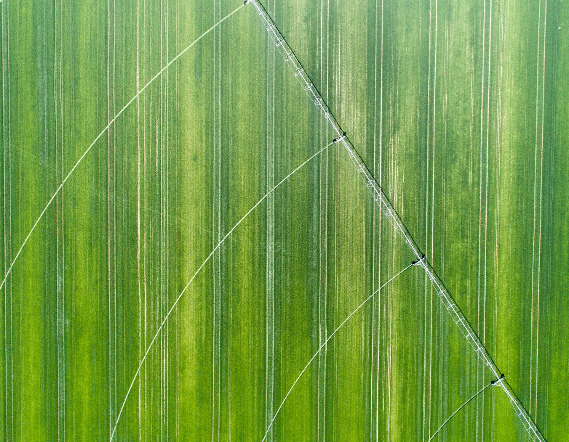
Maximize Yield, Minimize Risk with Earth Intelligence
Planet’s high-resolution, high-frequency satellite solutions provide critical insights for productive, profitable, and sustainable farming.
Precision agriculture powered by Planet.


Planet for agriculture
Maximize Yields and Ensure Crop Health with Reliable, High Frequency Satellite Imaging
Planet provides the most current and complete agricultural insights across every region and season. With Planet, you can help growers understand crop health from preseason to harvest, to farm more efficiently, profitably, and sustainably.
High Frequency
Near-daily in-season revisit rates powered by hundreds of satellites in space
Global Coverage
Broad area monitoring of agricultural regions worldwide
Field-Level Detail
0.5 and 3-5 meter resolution satellite images
Accessible API Platform
Simple APIs for seamless integration into your existing workflow
Deep Historical Archive
Over 1,300 images for every acre on earth
Planet’s daily stream of high-resolution satellite imagery enables precision agriculture at scale, even in regions with frequent cloud cover. Providing a combination of broad area coverage, field-level detail, frequent in-season revisit rates, and rapid access, Planet provides valuable input at each stage of crop management. With simple cloud-based APIs, Planet data can be integrated into your software pipeline with ease.
![[object Object]](https://cdn.sanity.io/images/hvd5n54p/production/dda847b2f4256f475fc7af7db0b83e77918bb3dd-2500x2500.png&w=1200?auto=format)
PlanetScope (RGB)
0
1
![[object Object]](https://cdn.sanity.io/images/hvd5n54p/production/bbbf105c40088fcd90b57792740d4c8cd894a027-2500x2500.png&w=1200?auto=format)
PlanetScope (NDVI)
0
1
![[object Object]](https://cdn.sanity.io/images/hvd5n54p/production/e2b4d3ac07b0a21ada40e01f9f8dd07b582040f0-2500x2500.png&w=1200?auto=format)
Soil Water Content (m3/m3)
0.1
0.3
![[object Object]](https://cdn.sanity.io/images/hvd5n54p/production/e12792b0bbb7bc3c78e913f743f1fc7e256fe510-2500x2500.png&w=1200?auto=format)
Land Surface Temperature (°K)
300
330
![[object Object]](https://cdn.sanity.io/images/hvd5n54p/production/dab1565eade9736219803549c3825de3aaa0d167-2500x2500.png&w=1200?auto=format)
Crop Biomass
0
1
True Color
Vegetation Index
Soil Water Content
Land Surface Temperature
Crop Biomass
Optimize Every Stage of the Season
Drive precise, profitable decisions from preseason to harvest
Planet 3.7 meter resolution satellite imagery enables precision digital agriculture and pest detection at scale. Access to this daily data supports informed crop management decisions, allowing farmers and agronomists to monitor and maximize their crop health each season.
Define Management Zones
Analyze years of archival data to map soil variability and define precise management zones for seeding and fertility before the season starts.
Direct Field Scouting
Detect early signs of stress — like pests or disease — and guide scouts exactly where they are needed, reducing labor costs and response time.
Optimize Inputs and Irrigation
Monitor crop biomass and soil moisture to tailor irrigation and chemical applications, lowering input costs while protecting yield potential.
Automate Analysis
Streamline operations by integrating analysis-ready data directly into your platform to automate vegetation indices like NDVI at scale.
Harvest Stratification provides the ability to make the appropriate agronomic decisions for different parts of the field, optimizing overall field stability.
Case Study: Optimizing Product Supply at a Global Scale to Build More Efficient and Resilient Food Systems
Bayer leverages Planet's imagery and analysis-ready data products to optimize product supply at a global scale, looking at daily data feeds spreading across four continents, thousands of fields, and hundreds of thousands of hectares of cropland.
Learn more about how this partnership enables groups from Breeding to Product Supply to make data driven decisions that optimize farming practices, increasing predictability in seed production and building more efficient and resilient food systems.
Read MoreEnable and Monitor Best Practices for Sustainable Agriculture
Optimize inputs and verify sustainability commitments with Planet broad area monitoring and granular resolution
Sustainable practices in agriculture can help regenerate soil health, store carbon, and decrease environmental impacts. Planet’s science-grade data can help verify adoption of decarbonization efforts, make it easier for growers to optimize their inputs and make more efficient and ecologically sustainable decisions.
Optimize Input Usage
Leverage field level data to avoid over-fertilization
Improve Irrigation Efficiency
Provide irrigation recommendations to conserve water
Drive Best Practices
Assess the implementation of conservation tilling and cover cropping

Field-level soil moisture data for a farm in Nebraska, USA on July 13, 2025.
Case Study: Manna Irrigation is Leveraging Planet Satellite Imagery to Improve Irrigation Intelligence
As water becomes an increasingly precious commodity, we must change the way we use it — particularly within agriculture. Using Planet imagery, Manna Irrigation provides growers with irrigation recommendations, crop monitoring maps, and irrigation planning tools.
Build On Planet Insights Platform
Infrastructure for Digital Agriculture
Don’t just access data — integrate intelligence. Planet provides the scalable infrastructure, deep archives, and robust APIs you need to power your applications. From training machine learning models to deploying customer-facing dashboards, leverage our cloud-native processing and analysis-ready data to accelerate development and deliver value faster.

Planet Monitoring
High frequency,
global coverage
Planet Tasking
On-demand, high-
resolution images
Crop Biomass
Cloud-free daily biomass estimations
Soil Water Content
High-frequency soil moisture estimations
Case Study: Disagro Transforms Tropical Agriculture with Planet’s Crop Biomass
Farming in tropical regions like Central America often means dealing with persistent cloud cover that blinds traditional optical satellites. To solve this, leading agricultural company Disagro® integrated Planet’s data into their AgritecGEO® platform.
By leveraging Planet high-frequency imagery and Crop Biomass data, Disagro® can "see through" the clouds. This allows farmers to monitor crop health daily, visually detect changes in vegetation, and make critical decisions about irrigation and fertilization — even when the sky is gray — ensuring efficient and sustainable production.

A view of Disagro’s AgritecGEO® platform displaying Planet data, allowing for continuous crop monitoring even during cloudy conditions.
Scale Your Solutions with Global Crop Intelligence
Whether you are building a digital platform or managing global supply chains, Planet provides the reliable, daily data infrastructure you need to innovate and grow. Ready to talk? Reach out to learn how Planet is working with leading agriculture businesses to turn data into competitive advantage.
© 2026 Planet Labs PBC. All rights reserved.
| Privacy Policy | California Privacy Notice |California Do Not Sell
Your Privacy Choices | Cookie Notice | Terms of Use | Sitemap
