Search
PLANET AREA MONITORING SERVICE
Minimize Inconclusive Parcels and Simplify CAP Compliance
Planet AMS gives paying agencies reliable, field-level visibility throughout the growing season
THE CHALLENGE
The Burden of Inconclusive Results
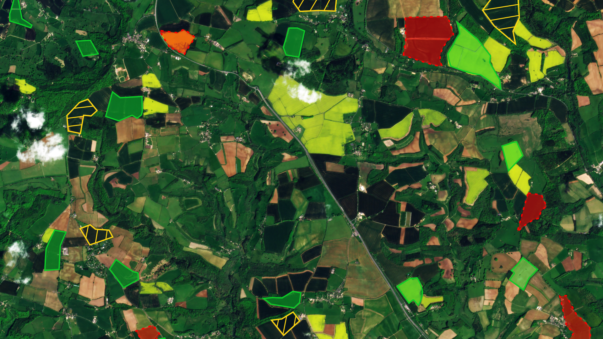
For National Paying Agencies, every inconclusive result requires a human-in-the-loop. Too many inconclusive parcels drain budgets on Controls with Remote Sensing (CwRS) and On-the-Spot-Checks (OTSCs).
Fragmented data and restricted visibility into small or narrow fields force teams to manually piece together evidence, leading to backlogs and missed payment deadlines. Relying solely on public satellite data can miss time-sensitive events, leading to disputes and reduced public confidence.
OUR SOLUTION
One Provider for Data and Decisions
Planet AMS minimizes inconclusive parcels by blending public Earth observation data with high-resolution Planet imagery where needed, reducing the blind spots caused by cloud cover or small fields.
Powered by the Planet Insights Platform, the solution reduces the technical burden on paying agencies to process satellite data and manage complex AI-driven workflows.
Planet AMS speeds up decision-making by generating field-level indicators, such as mowing, bare soil, and crop type, and converting them into clear compliance outcomes.
Key Benefits for Paying Agencies

Faster, More Detailed Decisions
Gain insights throughout the growing season to improve visibility into small farms or cloud-affected areas and reduce data-processing bottlenecks.

One Unified Service
Access analysis-ready inputs and decision tools through a single provider. We combine public EO data and high-resolution Planet imagery to provide the most comprehensive, gap-free insights.

Reduce Operational Costs
Reliable monitoring minimizes the need for costly OTSCs, while Planet Insights Platform handles the complexity of EO data analysis, allowing you to focus on making decisions, not managing data.

Support Greater Public Confidence
Ensure fair and consistent payments with near-daily insights. Objective, field-level evidence strengthens transparency and helps you communicate clearly with beneficiaries.
WHAT OUR CUSTOMERS SAY
Trusted by Leading Paying Agencies
National Paying Agencies across Europe are already leveraging Planet AMS to accurately track and verify agricultural activity at scale.

Slovenian National Paying Agency (ARSKTRP)
The Slovenian government partnered with Planet to develop a comprehensive AMS for nationwide CAP compliance.
Slovenia’s landscape is dominated by small and narrow fields, which public satellite data alone cannot monitor reliably. To address these gaps, the agency included high-resolution Planet data alongside Planet AMS.
The approach reduced inconclusive parcels by 73% and saved more than €1 million annually in manual checks.

England’s Rural Payments Agency (RPA)
RPA used Planet data to transform its ability to verify compliance with sustainable farming practices on a national scale.
With Planet, the agency reduced the time needed to preprocess satellite imagery from nine months to just two weeks and allowed compliance checks to cover 100% of agricultural areas, compared to just 2% previously.
OUR TECHNOLOGY
How Planet Area Monitoring Works
1
Nationwide coverage with analysis-ready data
Pre-processed, analysis-ready satellite data delivers reliable visibility across declared parcels.
2
Configurable decision-support
Reliable signals and markers feed into a configurable decision tree that reflects each agency’s rules and programme requirements.
3
Farmer mobile app for evidence submission
Farmers can upload supporting information directly from the field, with evidence automatically linked to the correct parcel.
See it in Action
LEARN MORE
Connect With Our Experts Today
© 2026 Planet Labs PBC. All rights reserved.
| Privacy Policy | California Privacy Notice |California Do Not Sell
Your Privacy Choices | Cookie Notice | Terms of Use | Sitemap
