Search

Credit: Virunga National Park
Project Centinela: Enabling Conservation and Economic Development in Virunga National Park
How National Park staff and Microsoft AI for Good Lab use Planet imagery to monitor deforestation and support smallholder farmers
Scroll to Learn More
Credit: Virunga National Park
Virunga National Park, a UNESCO World Heritage Site, is located in the eastern region of the Democratic Republic of the Congo, bordering Uganda and Rwanda. It spans 3,000 square miles (7,800 square kilometers), and is home to more than 3,000 species, including elephants, hippopotami, eastern lowland gorillas, and about a third of the world’s remaining population of endangered mountain gorillas.

Eastern lowland gorilla in Virunga National Park. Credit: Virunga National Park
Despite being in a region impacted by conflict, the park is protected by a dedicated team of more than 760 rangers. In addition to preserving its rich ecosystem, the Park aims to responsibly harness its natural resources to drive economic transformation in the region through job creation and poverty reduction.
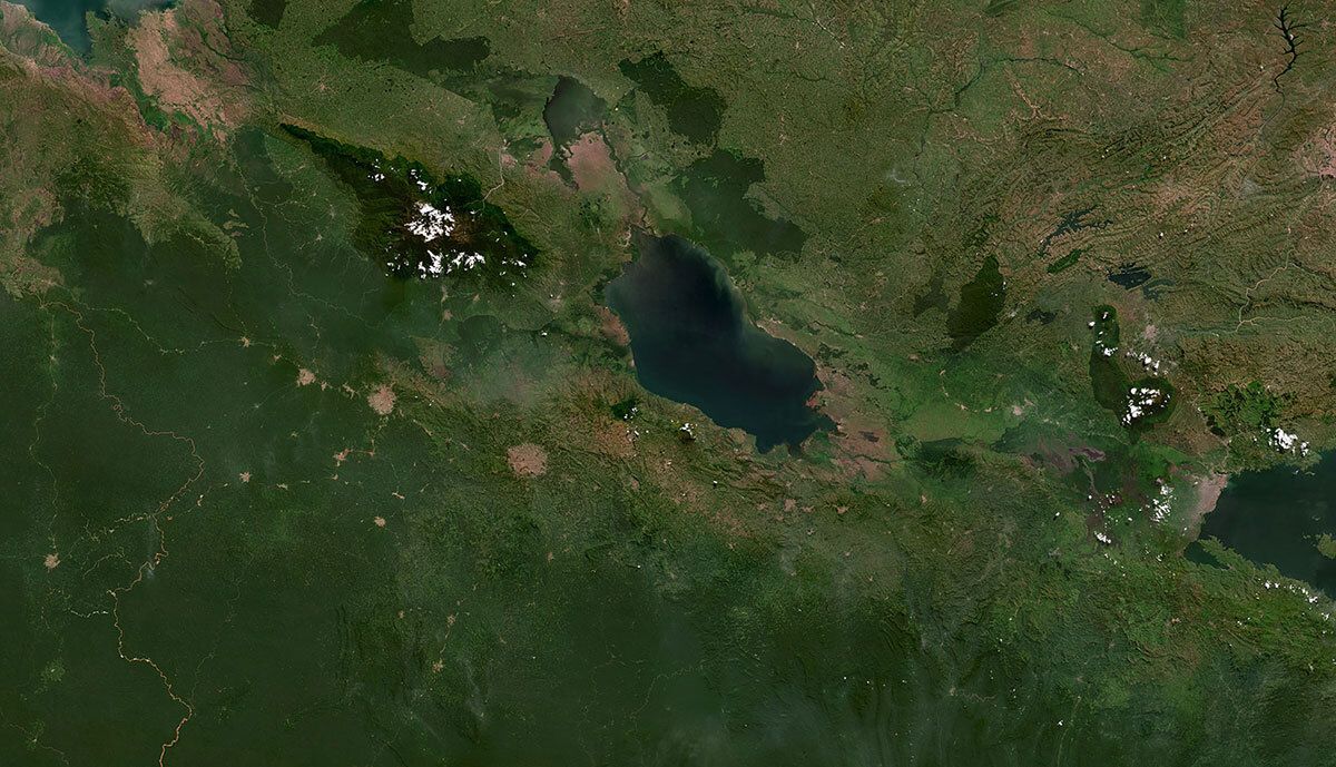
Virunga National Park, DRC. PlanetScope Mosaic Q1 2023, oriented with East at the top.
The Park's survival depends on its ability to act as an asset to the community. Therefore, Microsoft AI for Good Lab and Virunga National Park are working toward goals that conserve the park's resources, reduce poverty, and promote peace.
Project Centinela strengthens our ability to monitor and protect Virunga National Park. With the visual and analytic satellite data provided by Planet, we can track changes in forest cover, quickly detect any signs of deforestation, and demonstrate that our community projects do not contribute to forest loss.
This information helps us ensure that all our raw materials come exclusively from non-deforested areas, while providing solid evidence of compliance with EUDR certification requirements and other international environmental standards.
Cibalonza Bahati Esther
Traceability System Supervisor, Virunga National Park
Credit: Virunga National Park
The broad spatial coverage of PlanetScope near-daily scenes and mosaics enhances the team’s ability to quickly spot habitat destruction and survey the park’s boundaries for deforestation.
Deforestation Evaluation and EU Compliance for Agro-Farms (DECAF)In line with its mission to reduce poverty in the region, Virunga National Park works with 6000 smallholder farms to produce agro-products for sale. To maintain their ability to partake in international markets, these smallholder farms need to demonstrate that they have been farming without deforesting the land since 2020, in accordance with the European Union Deforestation Regulation (EUDR).
The project team is supporting smallholder farmers to verify deforestation-free practices. Using PlanetScope Mosaics, Microsoft AI for Good Lab developed a machine learning method to assess forest change at high resolution against a 2020 baseline. The method, called DECAF, has been key to monitoring deforestation and confirming smallholder claims.
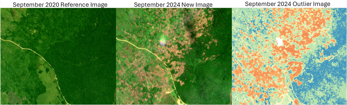
PlanetScope Mosaics from September 2020 and September 2024 near Virunga National Park, which the DECAF method uses to compare forest change. Credit: Microsoft AI for Good Lab
With Planet data and Microsoft AI for Good Lab’s AI-driven analyses, Virunga National Park staff can monitor the park more effectively to mitigate deforestation and conflict, while uplifting communities and promoting sustainable livelihoods.
Looking ForwardVirunga National Park staff anticipate continuing to use mosaics to track deforestation around the park’s boundaries and support smallholder farmers. Going forward, the project team will use high-resolution SkySat tasking to inspect individual farms and improve access to markets.
LOCATION
Virunga National Park, DRC
USE CASE
Monitor deforestation
TOOLS USED
PlanetScope
Mosaics
SkySat
IMPACT
1 Protected and conserved area
1 Key Biodiversity Area
21 Threatened and endangered species
© 2026 Planet Labs PBC. All rights reserved.
| Privacy Policy | California Privacy Notice |California Do Not Sell
Your Privacy Choices | Cookie Notice | Terms of Use | Sitemap
