Search

Credit: National Trust for Nature Conservation (NTNC)
Project Centinela: Mapping Water and Grassland Dynamics for Tiger Conservation
How Save the Tiger is using Planetary Variables to understand grassland habitat conditions and support positive outcomes for wildlife and local people.
Scroll to Learn More
Credit: National Trust for Nature Conservation (NTNC)
The Terai Arc Landscape, at the foot of the Himalayas in Nepal and India, is critically important habitat for endangered greater one-horned rhinoceros, Asian elephants, and Bengal tigers. These species are confined to “conservation islands” in protected parks within a human-dominated landscape, dependent on grassland floodplains and forests in dynamic river systems. Although around 100,000 tigers roamed the Earth at the beginning of the 20th century, fewer than 4,000 remain today.
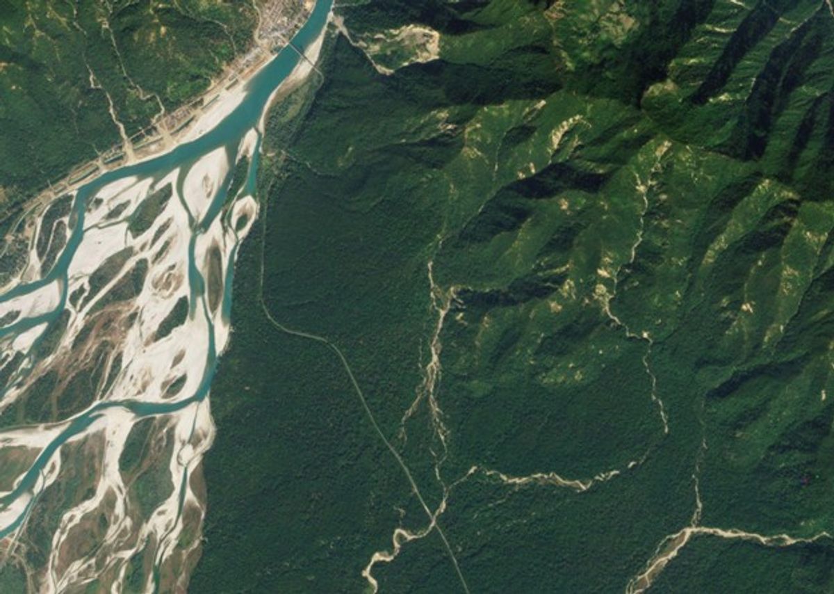
PlanetScope image of Bardia National Park, Nepal. Captured December 1, 2023.
In recent years, Nepal has seen restoration success in this landscape through conservation and management interventions led by the government and nonprofit partners like the National Trust for Nature Conservation. The Bengal tiger population in Nepal has increased threefold over the past decade, more than fulfilling contributions to the global goal of doubling tiger numbers by 2022. However, experiences of human-wildlife conflict have also risen, with extreme consequences for local communities.
This is extraordinary! Remote sensing lets us travel back in time and to inaccessible locations to provide insight into the required amounts of water in the river for a sustainable situation for people and wildlife on land.
Jitse Bijlmakers
Researcher for Save the Tiger Project and PhD candidate, Utrecht University
Credit: Rabin K.C. (NTNC)
In the Terai Arc Landscape, human-wildlife conflict is being driven by diminishing habitat and prey for tigers within protected areas. Compounding these issues, the Karnali River shifted its main course away from Bardia National Park in 2009, changing hydrological conditions and leaving the park with limited freshwater during dry periods. Future hydropower projects upstream may further disrupt the natural flow regime – threatening Bengal tiger populations and potentially driving them into vulnerable communities in the region.
Without regular monitoring and understanding of hydrology-driven species dynamics, communities and decision makers are left with more questions than answers. In this data-scarce environment, data-driven park and water management can support conservation of flagship species by improving understanding of the natural processes that sustain healthy habitats, thereby reducing conflict and helping communities prepare for changing conditions.
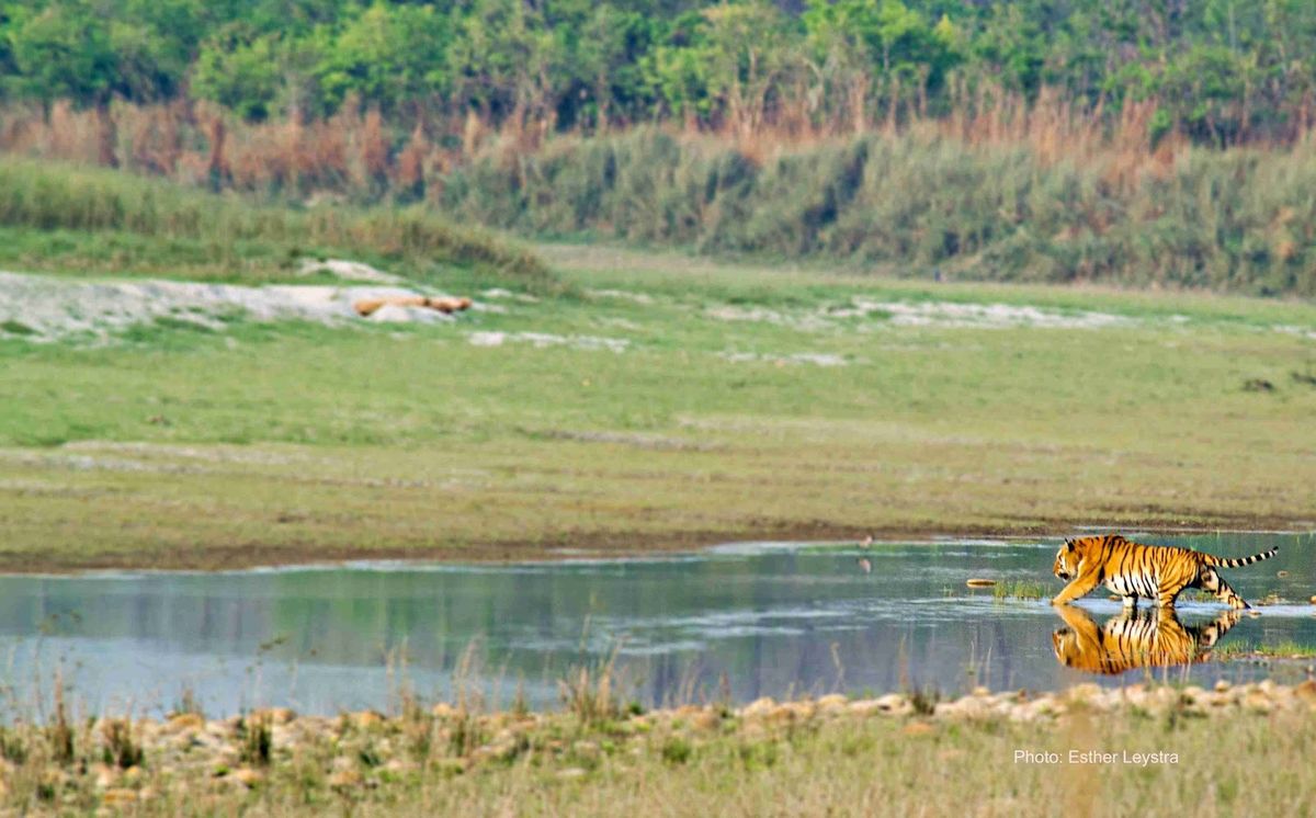
Endangered Bengal tiger in the Terai Arc Landscape in Nepal. Credit: Ester Leystra 2019
Planet imagery and analytics play a pivotal role in enhancing understanding of freshwater and wildlife dynamics to inform data-driven management. Planet datasets offer regular, detailed information on remote and hard-to-reach areas in the Terai Arc Landscape, helping track environmental changes over time and guiding adaptive management practices for both people and wildlife. Two use cases in Bardia National Park illustrate Save the Tiger’s work as part of Project Centinela.
Monitoring Grassland Habitat QualityChanging hydrological conditions are affecting the growth and health of Bardia National Park’s grasslands, including managed short grazing lawns and tall grasslands (>3m) that serve as prime habitat for the Bengal tiger and an important food source for the greater one-horned rhinoceros. Observers suspect that decreasing water flow in the park has deteriorated riverine grasslands, driving rhinoceros across the border to India and leading to a 25% drop in Bardia’s population.
Save the Tiger Project is evaluating soil moisture conditions in the national park before and after the river channel shifted in 2009, and in different grassland types along the river. In time-series analysis, researchers are comparing Planetary Variables Soil Water Content and Crop Biomass with field data on grassland quality indicators, such as nutrient content. The results inform management decisions about whether and how much to restore the Karnali River’s flow to Bardia National Park.
Advanced GIS and satellite data help bridge NTNC’s on-ground expertise with large-scale landscape analysis, enabling a deeper understanding of wildlife and ecosystem dynamics across time and terrain to support better conservation decisions.
Bishnu Singh Thakuri
Senior Conservation Officer and GIS Focal Point, National Trust for Nature Conservation (NTNC)
PlanetScope
To address decreasing water availability since the change in the Karnali River channel, the government of Nepal has established around 200 artificial ponds in Bardia National Park to secure drinking water for wildlife. Although some of these small watering holes are powered by ground water pumps, many dry up during the dry season, at a time when water availability is crucial to sustain animal populations.
Save the Tiger Project used PlanetScope to detect these ponds and assess water availability for wildlife during the dry season. By actively monitoring these ponds, the team is identifying where water availability is below critical thresholds and helping Park staff prioritize ponds for maintenance, including repairing ground water pumps and removing clogging vegetation.
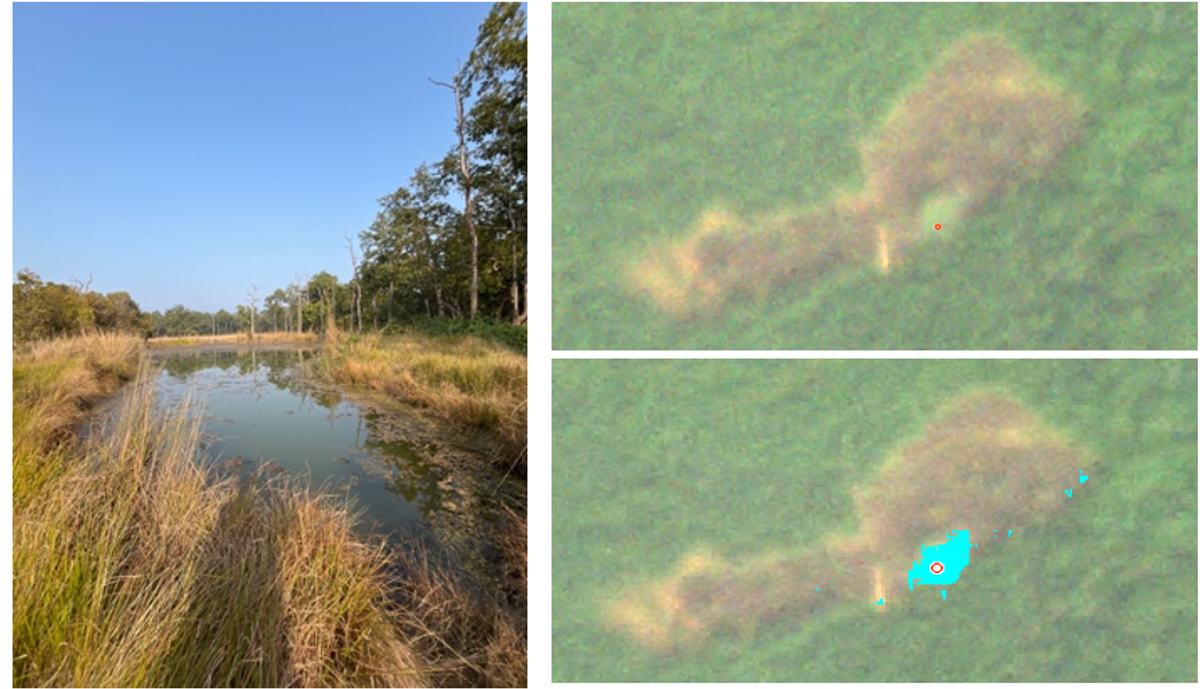
Artificial water ponds as seen locally in Bardia National Park and with PlanetScope imagery. Credit: Gijs Vellekoop
Planet data has been instrumental in evaluating watershed and grassland dynamics, and helping determine habitat integrity for endangered tiger, rhinoceros and elephants in this remarkable landscape. These insights translate into management recommendations for restoring wildlife populations and reducing human-wildlife conflict, supporting more sustainable outcomes for the Terai Arc Landscape in Nepal.
Looking ForwardMentoring and knowledge exchange are key components of Save the Tiger’s approach in this site. The core team has academic experts and Nepalese practitioners, who are testing remote sensing methods for park management to replicate and scale across the landscape. Over the course of the project, the team plans to offer stakeholder workshops and educational outreach on the findings of grassland and water dynamics research. These activities will engage park managers, local communities, nature organizations, universities, and policymakers. In addition, the team holds workshops for Nepalese conservation organizations to exchange knowledge and build capacity on remote sensing technologies for park management.
Bengal tiger in Bardia National Park. Credit: Matteo Sciumbata, Save the Tiger Project
LOCATION
Terai Arc Landscape, Nepal
USE CASE
Assess habitat quality for key species
TOOLS USED
PlanetScope
Crop Biomass
Land Surface Temperature
Soil Water Content
COLLABORATORS
Save the Tiger! Save the Grasslands! Save the Water!
National Trust for Nature Conservation (NTNC), Nepal
Nepal Department of National Parks and Wildlife Conservation
IMPACT
3 Protected and conserved areas
10 Key Biodiversity Areas
>50 Threatened and endangered species
© 2026 Planet Labs PBC. All rights reserved.
| Privacy Policy | California Privacy Notice |California Do Not Sell
Your Privacy Choices | Cookie Notice | Terms of Use | Sitemap
